Introduction
This is public parkland comprising a lake spanned by a five-arched bridge, tree belts and individual trees. The house was demolished in the 1960s, but the remaining parkland was purchased by the local authority and reunited with that of adjacent Foots Cray Place to become Foots Cray Meadows, Bexley’s largest public open space.
North Cray Place is one of five sites in Kent where there is both documentary and physical evidence that Lancelot ‘Capability' Brown carried out alterations to the landscape in the C18. Substantial payments from Thomas Coventry, the owner of North Cray Place, are recorded in Brown's account book and a number of features including a ribbon lake, bridge and mature trees survive within the parkland landscape.
The site has an extended history of occupation, first as a manor recorded in the Domesday Book.
The site reflects the way fashion shaped the landscape and the houses of estates in the C18 and C19, the English landscape style of Brown's work accommodating both aesthetic pleasure and the application of new farming technologies.
The site also reflects the way that Brown acquired clients, as Thomas Coventry was the nephew of the 5th Earl of Coventry whose son (the 6th Earl) commissioned Brown at Croome.
North Cray Place, along with the adjacent Foots Cray's parkland, now forms Foots Cray Meadows which has provided a public amenity since coming into local authority ownership in mid C20, and is now (2015) the largest open space in the London Borough of Bexley. This acquisition, along with that of nearby Danson Park (designed by Nathaniel Richmond, a pupil and follower of Brown), reflects the local authority's pro-activity in providing open space during this period.
Ecological significance lies in the several uncommon plants occurring in the marsh meadows of Foots Cray Meadows which supports diverse wildlife. The river is possibly London's best tributary in terms of water quality.
SITE DESCRIPTION
LOCATION, AREA, BOUNDARIES, LANDFORM, SETTING
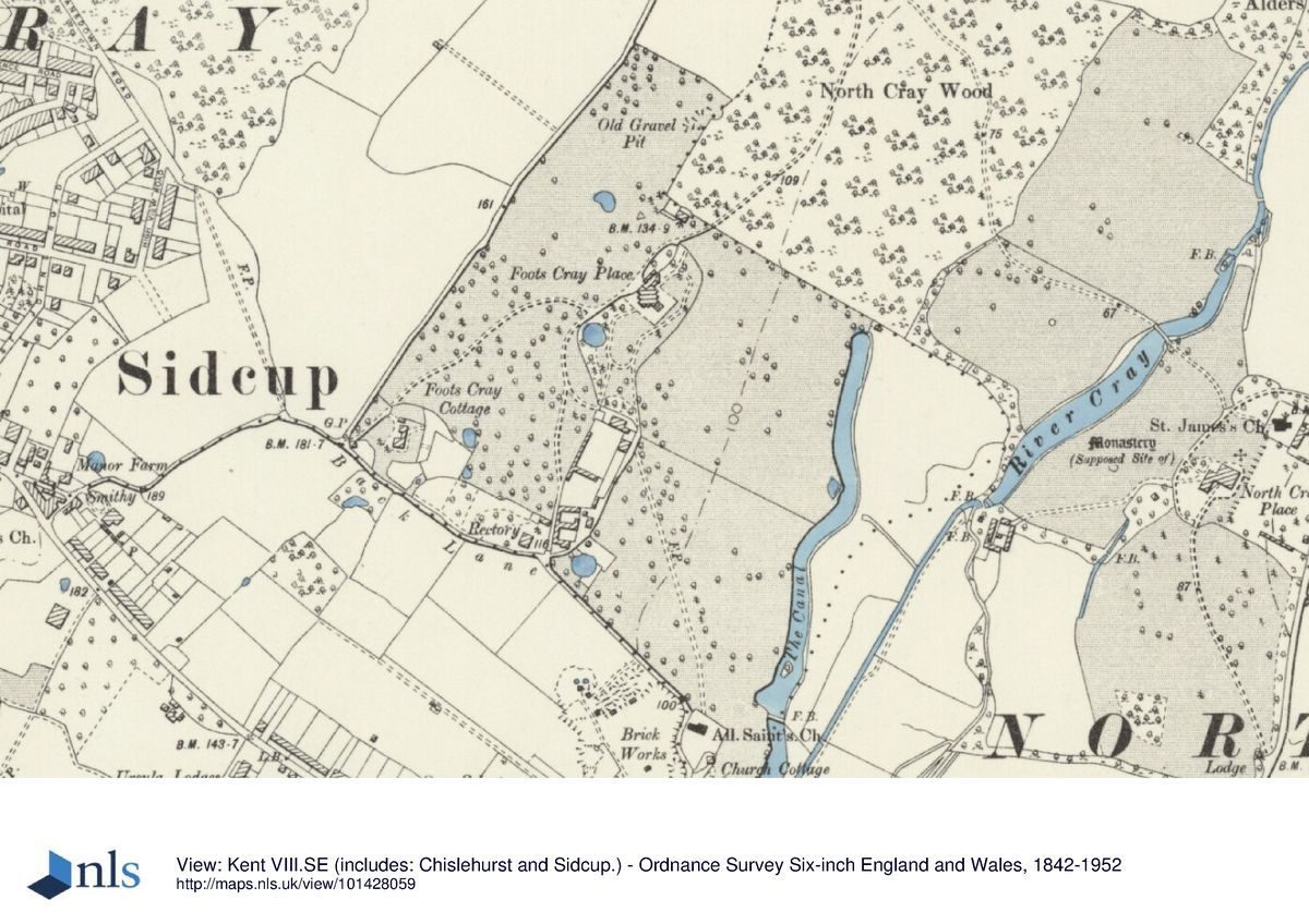
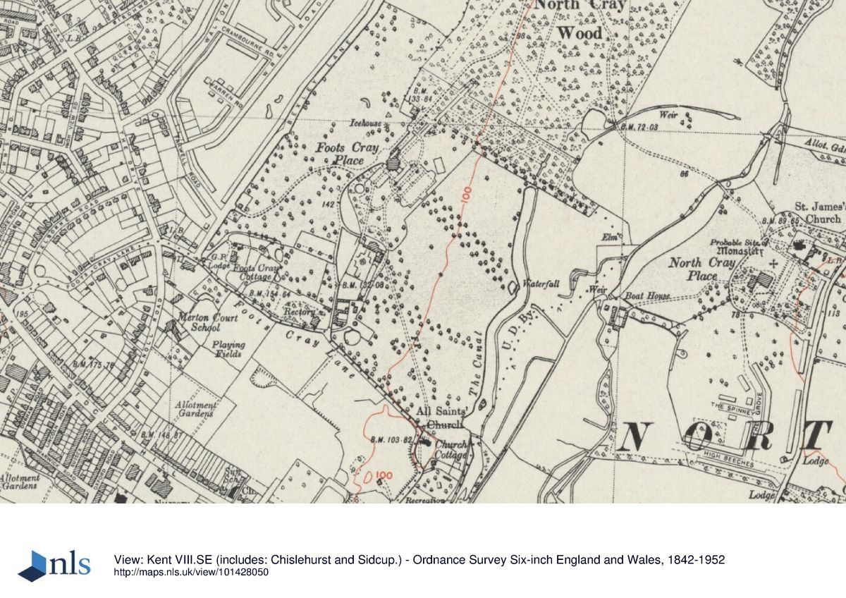
The North Cray Place estate (included within the area of the grade II registered site of Foots Cray Meadows) lies 2.5km south-west of the village of Old Bexley and 1.0km north-east of the village of Foots Cray. The town of Bexleyheath lies 4.0km to the north. The site lies on the west side of the A223 North Cray Road but is partly separated from the road by mid C20 housing. The estate, together with the former Foots Cray estate to its immediate west, now forms the eastern part of Foots Cray Meadows, an area of 97ha and the largest open space in the Borough.
The approximately 25ha site of North Cray is bordered on its west side by the former Foots Cray estate, a culverted water course running northwards to the river Cray forming the southern 300m of this boundary. A tree belt running north-west for 250m and North Cray Woods form the remainder of the western boundary. Early and mid C20 housing forms the southern, and the southern half of the eastern boundaries. The A223 North Cray Road abuts the northern half of the eastern boundary, north of St James church; this section is unfenced.
Royal Park School, mid C20 housing, and Stable Meadows sports ground encircle the northern end of the estate which narrows to approximately 200m wide and extends 300m northwards.
The meandering River Cray bisects the site from south to north narrowing from a ribbon-like lake towards the north. The land either side is fairly level though on the western side it slopes gently down towards the river. The River Cray is possibly London's best tributary in terms of its water quality and its relatively naturally graded profile. Foots Cray Meadows contain much ancillary parkland of low wildlife interest, but the marsh meadows adjacent to the river on the west side are of high species diversity with several uncommon plants. The area also supports a diverse range of wildlife.
ENTRANCES AND APPROACHES
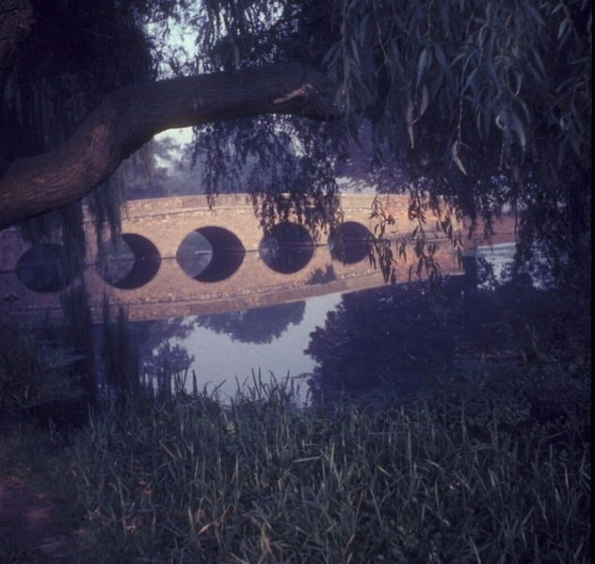
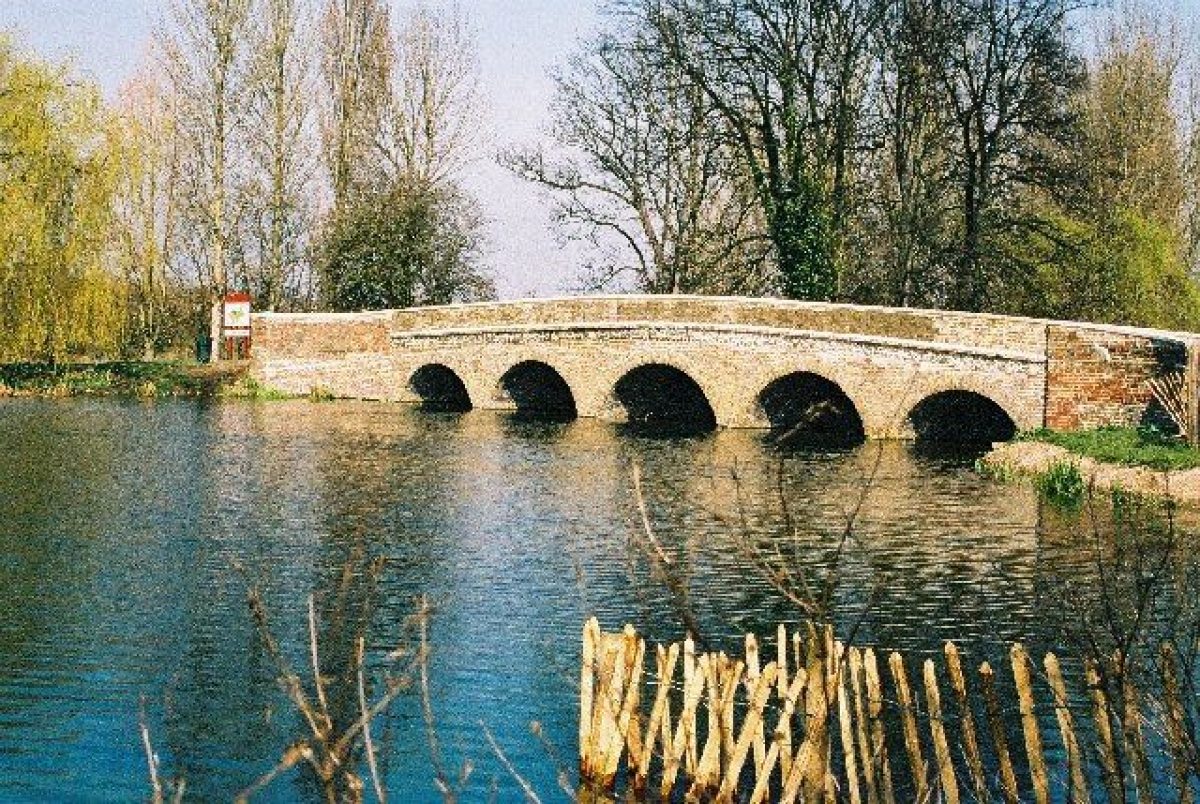
As North Cray estate is now combined with the former Foots Cray estate to the west, the majority of its western boundary is unfenced, providing unimpeded pedestrian access. Three bridges over the River Cray provide east/west access across the estate. At the southern end a riverside footpath from Pennyfarthing footbridge (some 200m to the south and outside the former North Cray estate) provides access from the south-west and All Saints Church while Five Arch Bridge (listed grade II) at the north end of the lake provides the main crossing point. This bridge is described in the 1833 sale particulars as providing a route "to the Eltham lanes, thereby avoiding the Turnpike Road through Foot's Cray". This bridge, now (2015) much rebuilt, formerly led to a lodged entrance to the estate, approximately 0.5km to the north-west, on the northern boundary of North Cray Woods. A bridge also formerly spanned the southern end of the lake, some 350m upstream of the Five Arch Bridge; shown on North Cray Place sale map of 1833 and on all OS editions until 1940, it was presumably then demolished. This bridge, coupled with the Five Arch Bridge, created a circular walk from North Cray Place to North Cray Woods. At the north end of the estate a C20 steel footbridge provides access over the river from the north-west corner of the estate to the east side of the river, onto land which is outside the former North Cray estate. Footbridges are also shown downstream of the Five Arch Bridge on various OS maps but none survive, although a ford c250m downstream from it has survived. This ford marks a crossing of the river found on most of the maps, one of which dated about 1910 denotes the crossing as One Arch Bridge (Bexley Local Studies and Archive Centre PEVAN4/144).
The main approach to the estate from the late C18 was from the south-east through a lodged entrance in the south-east corner, off the North Cray Road which provided the eastern estate boundary. The lodge has survived but is now surrounded by mid C20 housing. It bears the date 1891 and the initials RAV, standing for Robert Arnold Vansittart, who lived at North Cray Place in the late C19. The lodge is first shown on the 1833 sale map as a pair of buildings which flanked the main entrance; the lodge was reduced between 1873 and 1893-1897 (1st and 2nd edition maps, although the date mark of 1891 suggests that year) to a single building on the west. It is now (2015) known as 68 St James' Way and has been extended on its western side.
A pedestrian entrance on Water Lane, on the northern boundary, gives access to the bridle paths which circulate around the estate. There are further entrances on the unfenced eastern boundary from North Cray Road, north of St James's Church and from the churchyard itself through a gateway in its west wall. The gateway supports imposing C18 wrought iron gates which originally included the initials HH recording the Hetherington family, these now replaced by a cross. A wide entrance off the road provides vehicular access to the church and churchyard and, 25m further north, a pedestrian path marks the site of the former entrance to the coach house and stables of North Cray Place, demolished c1960. The roads which provide access to the early and mid C20 housing forming the south-east site boundary also create an unfenced approach to the estate from the south-east.
PARKLAND
The River Cray meanders northwards through the centre of the site which is laid out as parkland. The land on both sides of the river slopes gently upwards from the river to the site boundary. The riverside parkland is fragmented by C20 scrub, shrubbery and tree belts into several smaller open grassy spaces. Late C20 scrub growing along the river bank limits views of the river from these spaces and also of views across the lake from its eastern side westwards to the areas of the Meadows beyond on the former Foots Cray estate land. Allotments covering one hectare occupy the north-east corner of the former parkland.
Where the river enters the site at the southern boundary it widens into a narrow lake 40m wide by 280m long. The lake contains a series of islands which are mid-late C20 as they are not recorded on the 1st to 4th edition OS maps. Alterations to the river are first apparent on the 1799 OS surveyor's drawing. It has been widened into its current narrow form to create a lake held back by a weir some 25m wide which supports a bridge, known as the Five Arch Bridge, probably built as part of Brown's landscape works to provide a crossing for the path from the church to North Cray Woods. A crossing is recorded on earlier maps (Andrews and Faden) but no details are shown. At some time a "Teissert" turbine was installed within the weir to drive a 6kw turbine to provide electricity for the house (Bexley Local Studies and Archive Centre P728.8NOR). Downstream of the bridge the surveyor's drawing shows a lower lake 150m long reducing from 25m to 5m wide, the narrowing controlled by a sluice, the brickwork remains of which survive; northwards beyond the former sluice the river meanders for a further 700m to the site boundary through a mixture of C20 tree belts and scrub which from about 1905 to 1940 is denoted on OS maps (2nd to 4th editions) as "The Alders" suggesting a managed crop during this period.
Two islands (referred to as "eyotts" on the 1833 Sale Particulars) downstream of the bridge are shown on the 1799 drawing. By 1893-97 (2nd edition OS map) the lower lake has been narrowed and one island removed. By 1905 -1910 (3rd edition OS map) the land had encroached from the west to incorporate the second island so that now (2015) the lower lake has not survived reverting to a widened river. The 3rd and 4th edition OS maps also show a small lake on the edge of North Cray woods draining along a ditch towards the river which has not survived. The 1799 drawing indicates more buildings adjacent to the river downstream of the Five Arch Bridge but its poor quality does not allow any other features to be identified.
The OS drawing is the first to record the estate land laid out as parkland, although the estate map produced for the sale in 1833 and the Tithe map of 1838 give the clearest record of the changes that have taken place since 1769 (Andrews map). An oval pond surrounded by trees 50m north of the house is one change which may have been created by Brown, though this feature has gone on all later maps. The Tithe Apportionment records the land on the west side of the river as parkland except for the most northerly field, which is recorded as pasture and a narrow wooded strip forming the southern boundary on west side of the river denoted as "Pleasure Ground and Shrubbery". This narrow wooded strip extends eastwards from the river towards the house and is described as "Plantation and Walks" in the Apportionment and would thus have obscured the farm buildings (gone by the mid C20) lying adjacent to the river at that point. These two features either side of the river may have been part of Brown's landscaping works.
The park has been extended to the south, on the east side of the river, by the inclusion of 9ha (21 acres) of meadow and the main drive and lodged entrance to North Cray Place. Perimeter tree belts screen the estate from the North Cray road and adjacent properties and tree clumps have been carefully placed to frame views along the route of the drive to the house, both typical of Brown's work. All these features are shown as surviving through the C19 (OS editions from 1858) but gradually are lost through decay and housing development during the C20. The narrow wooded strips either side of the river, forming part of the C19 walks, have survived but consist of mainly C20 deciduous trees. The rest of the estate land is scattered now (2015) with mixture of deciduous and coniferous trees, the size and age of some suggesting they may date from late C18 at the time of Brown's involvement.
The site of the former North Cray Place and its gardens lies to the east of, and outside the boundary of, the designated site and is now occupied by C20 housing on The Grove and St James Way. Some isolated mature cedar trees within the gardens of the housing along St James Way are of a size to suggest they also may be of C18 origin.
KITCHEN GARDEN
The former walled kitchen garden (c75m x60m) lies immediately to the east of the St James's church and north of the former gardens of North Cray Place and is now occupied by early and late C20 housing. Built in the early 19C most of its original perimeter brick walls survive apart from the east wall which was realigned during the building of the dual carriageway North Cray Road in 1960s. The west wall incorporates a bothy (now used for church meetings) with a door into the churchyard. The Vicarage was the first C20 dwelling to be constructed within the kitchen garden, being shown on the 4th OS edition 1936-40 and marked as such on an OS map 1963. Earlier editions of OS maps show the kitchen garden subdivided by paths to form a perimeter bed and four internal plots approximately 25x20m. A variety of glasshouses are shown against the boundary walls. The 1833 sales particulars of North Cray estate show the kitchen garden together with a gardener's cottage which was built into the east wall adjacent to the North Cray Road, lost during realignment of the North Cray Road.
Detailed description contributed by Kent Gardens Trust 11/05/2016
REFERENCES
Books and articles
Lancelot Brown's personal account book from 1764 onwards (in the care of RHS Lindley Library)
E Hasted, The History and Topographical Survey of the county of Kent Volume 2 (1797) pp141-162
Oliver Wooller, The Great Estates (2000) Bexley Local Studies and Archives Centre
Catherine Gordon, The Coventrys Of Croome (2000) Trustees of the Croome Estate
Jean Gammon, A History of North Cray (2012)
Maps
J Andrews, A Dury and W Herbert, A Topographical Map of the County of Kent in Twenty Five Sheets 1769 (Kent History and Library Centre)
William Faden, Map of North West Kent 1789 (Kent History and Library Centre)
Ordnance Survey Drawing 1799 (British Library OSD 129)
William Mudge, An Entirely New and Accurate Survey of the County of Kent 1801 (Kent History and Library Centre)
Tithe Map of North Cray 1838 (Kent History and Library Centre)
Ordnance Survey 6" to 1mile: 1st edition (1862-1875)
Ordnance Survey 6" to 1mile: 2nd edition (1898)
Ordnance Survey 6" to 1mile: 3rd edition (1910)
Ordnance Survey 6" to 1mile: Revised (1939-1940)
Ordnance Survey 1:2500 1963
Illustrations
Illustration of North Cray Place by J Bayly c1779, (Bexley Local Studies and Archive Centre)
Illustration of North Cray Place, the seat of Henry Meux Esq by John Hassell 1818. (Kent History and Library Centre ref NOC11xx)
Modern photographs courtesy of Lee Ricketts taken from https://www.youtube.com/watch?v=rGMJd3ml37Y&feature=youtu.be
Archival Items
Times Digital
History of parliament on line.
Diversion of Footpath 1781/2. Kent History and Library Centre Q/RH/2/12
Correspondance by John Coventry c1820. Worcester Archives 350/7/12/1/8
Marriage Settlement of Thomas William Coventry 1823. Kent History and Library Centre Q/RH/2/12
North Cray Place Estate Sale Particulars with estate map 1833. Bexley Local Studies and Archive Centre ref PEVAN/4/9
Kent Estates Map 1854 A Vansittart Esq. Bexley Local Studies and Archive Centre ref PEVAN/5/2
North Cray Golf Club 1906-09. Bexley Local Studies and Archive Centre ref PEVAN/4/26
North Cray Place Estate Sale Particulars with estate maps 1910 and1912. Bexley Local Studies and Archive Centre ref PEVAN/4/181 and 144
North Cray Place Estate Sale Particulars with estate map 1922. Bexley Local Studies and Archive Centre ref PEVAN/5/4
North Cray Place Estate Sale Particulars with estate map 1931. Bexley Local Studies and Archive Centre ref P728.8NOR
Parks and Gardens UK entry
Research by Geraldine Moon and Mike O'Brien
Description written by Mike O'Brien
Virginia Hinze (editor)
- Visitor Access, Directions & Contacts
Access contact details
Opening is unrestricted.
Directions
Rail: Albany Park, Sidcup. Bus: 492, B14.
Owners
London Borough of Bexley
- History
SUMMARY OF HISTORIC INTEREST
Public parkland comprising a lake spanned by a five-arched bridge, tree belts and individual trees which was laid out in the late C18 as a picturesque landscape for Thomas Coventry, a cousin of the 6th Earl of Coventry of Croome and which evidence suggests was the work of Lancelot ‘Capability' Brown. Of C17 origin, the house was rebuilt in the early C19 but demolished in the 1960s and its site, along with the eastern part of the park, built over in the mid C20; the remaining parkland was purchased by the local authority and reunited with that of adjacent Foots Cray Place to become Foots Cray Meadows, Bexley's largest public open space.
CHRONOLOGY OF THE HISTORIC DEVELOPMENT
From as far back as Neolithic times settled communities have left their mark in the area now (2015) known as Foots Cray Meadows; later around the C1 and C2 Roman colonisation is evidenced by the remains of a small ‘Romanised' villa or farmhouse on the site.
North Cray manor, located partly within the site of Foots Cray Meadows, was given by William the Conqueror to his half-brother Odo, bishop of Baieux, along with the manor of Ruxley which lay immediately to the south. Both manors are recorded in the Domesday Book whose survey was undertaken in c1086.
By c1190 the Rokesle family owned both manors; subsequently inherited by the Poynings and Percys, in 1538 all lands owned by the Percys were passed to Henry VIII. The King granted the manor, rectory and church of North Cray to Sir Roger Cholmley who sold it two years later to Sir Martin Bowes. In 1557 the two parishes of North Cray and Ruxley (Rokesley) were combined. The manor of North Cray was inherited by various members of the Bowes family and their descendants until about 1710 when John Buggin sold the manor, Manor house, rectory and church to Thomas D'Aeth.
In c1738 Jeffery Hetherington purchased the manor of North Cray. He died in 1767, unmarried, and left his estate to his brother, Rev. William Hetherington, both brothers being local benefactors. Jeffery and William are buried in a vault in the south-east part of the churchyard of St James which formed part of the manor. William died unmarried in 1778 and in his will his estate passed to his cousin Thomas Coventry of Serjeants Inn, Fleet Street, together with the manor of Ruxley.
When the 4th Earl of Coventry died in 1719 without an heir the Earldom reverted to the descendants of Walter Coventry, the brother of Thomas Coventry, 1st Baron Coventry (1578-1640). William Coventry (1678-1751) became the 5th Earl and his younger brother Thomas, a Russian merchant, married Mary Green and they had five children. It was their second son, Thomas Coventry (born c1713 and cousin of William Hetherington), who inherited North Cray Place in 1778. Thomas became a successful lawyer and c1743 married Margaret Savage, a daughter of Thomas Savage and Elizabeth Grimes of Elmley Castle Worcester, their estate lying adjacent to the Croome estate of the Earls of Coventry. Thomas and Margaret were already distantly related by marriage as Elizabeth Grimes had previously been married to the 5th Baron (and 1st Earl of Coventry) and on his death in 1699 had inherited his huge personal estate (The Coventrys of Croome). Thomas Savage outlived his wife and died in 1742 leaving his estate to his daughters Margaret and Elizabeth. The will was contested, with the whole estate eventually going to Elizabeth's son Thomas Byrche who changed his name to Savage. Later, the 6th Earl of Croome (1722-1809) who inherited in 1751, engaged Lancelot Brown to design and build a new house and to lay out the park.
At North Cray, Thomas Coventry also inherited other considerable property from his mother but was only left "one shilling and no more" by his father (historyofparliamentonline.org). He was elected MP for Bridport from 1754 to 1780 following other members of the Coventry family who had held that seat since 1708, with the exception of the 1747 election. Thomas was also a director of the South Sea Company from 1751 to 1768, deputy governor 1768 to 1771 and sub governor 1771 to 1794. He purchased Government stock to the value of £400k between 1754 and 1780 and died in 1797 in possession of stock to the value of £185k (historyofparliamentonline.org).
The earliest record of any formal layout of gardens and pleasure grounds around North Cray Place dates from 1769 (Andrews, Dury and Herbert map). Pleasure grounds laid out with paths and water features appear to extend north-west from the house across the River Cray as far as North Cray Woods which formed part of the western boundary of the estate. Various buildings are shown scattered around the pleasure grounds, some concentrated at the river's edge at the point where a road or path from St James church crosses the river to North Cray Woods at the site of the later five arch bridge. A near-contemporary drawing by J Bayly c1779 (a year before Brown was engaged) shows gardens to the south-east of the house divided into rectangular areas by rows of planting. Avenues of trees lead north-west to the river. Ten years later, William Faden's map of 1789 shows little change to the layout.
Thomas Coventry instructed Lancelot Brown in c1780 to carry out alterations to the estate at North Cray Place. Brown's account book records that he received £1300 in 1781/2 for the work. Payment of £1300 equates to at least £150,000 today, a substantial sum which would be sufficient for the building of a lake with a substantial bridge and altering water courses of the magnitude of those at North Cray Place, suggesting that Brown was responsible for its late C18 landscape. Evidence of Thomas having arranged in 1781/2 for a footpath crossing the estate in front of the house to be diverted along the road behind it suggests that works to the landscape were underway (Kent History and Library Centre ref Q/RH/2/12).
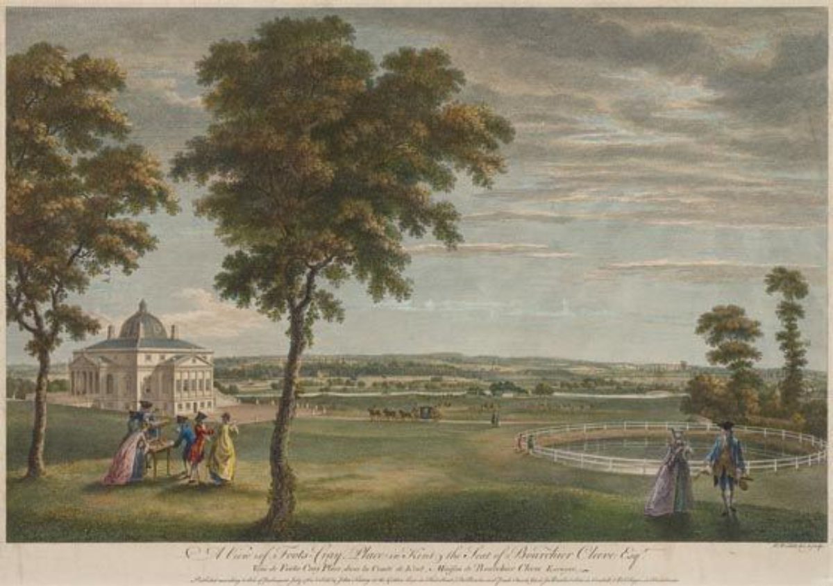
On his death in 1797, Thomas Coventry willed everything to his godson the Hon. Thomas William Coventry (1778-1816), the youngest son of 6th Earl of Coventry whose estate at Croome had been Lancelot Brown's first complete landscape design, carried out over several years from c1757. The Times recorded that ‘the effects of Thomas Coventry at North Cray Place were sold in 1797'. The Hon Thomas William married a Miss Clarke, an obscure woman from Evesham in 1801, but she died in 1806 and he died in obscurity and poverty in 1816 as his father, the 6th Earl of Coventry, did not leave him any inheritance following his marriage. (The Coventrys of Croome). The effects of the Hon. Thomas William Coventry at North Cray Place were sold in 1804 according to The Times. The estate passed to Thomas William Coventry (1800-1882), the son of the Hon Thomas William, who was only sixteen. John Coventry (1789-1852), the second son of the 7th Earl, mentions in a letter c1820 that general expenditure on the North Cray Estate during minority would be better kept in the hands of the future 8th Earl (Worcester Archives 350/7/12/1/8). During this period North Cray Place was leased to John Scott, a merchant of Tower Street London and Henry Meux of the Meux Brewery. In 1818 the artist John Hassell (1767-1827) produced an engraving of North Cray Place with a view of the five arched bridge entitled "North Cray Place, the seat of Henry Meux Esq."(Kent History and Library Centre ref NOC11XX and Bexley Local Studies and Archive Centre ANBNN/C/2)
In August 1821 the Times advertised that the contents of North Cray Place were to be sold for Thomas William Coventry as the house was to be taken down and rebuilt. Henry Walker designed a new mansion in the "Adam" style, of Portland stone and black marble. During demolition of this latter house in 1962 a beam was discovered which recorded that the house "was built in the year 1822-23 for Thomas William Coventry". It is likely that the farm buildings at the southern end of the lake, the coach house, stabling and clock tower just north of the path to the church (on the western side of North Cray Road) were built at the same time as sale particulars for North Cray Place in 1833 include these buildings (Bexley Local Studies and Archive Centre PEVAN/4/9). By the early C19 (tithe map and apportionment) the formal gardens and pleasure grounds are shown confined to an area east of the house, extending eastwards for 120m to North Cray Road and enclosed by a brick boundary wall, sections of which survive (2015). A long, tree-lined walk runs west from the house to a small bridge over the river at the southern end of the lake and then north-west to North Cray Woods (approximately 500m from the house) The walk appears to stop at the river by 1905-10 (3rd edition OS map) and is now replaced by mid C20 tree lined walks. The garden layout (first shown on the sale particulars of 1833) consisted of a series of straight paths with, by 1875-9 (1st edition map), additional meandering paths and plantings of mixed deciduous and coniferous trees.
In 1823 Thomas William Coventry married his cousin Anne Coventry, the youngest daughter of his uncle John Coventry (the 6th Earl's youngest son). The marriage settlement dated 17 August 1823 included various documents, one dated 16 August 1823 placed North Cray Place in a trust, the trustees being named as Thomas William, 7th Earl, Lord Viscount Deerhurst (heir apparent), Sir Roger Gresley (the Earl's son-in-law) and George Poulett. (Kent History and Library Centre U619/T6)
Thomas and Anne had seven children but separated in 1834 (The Coventrys of Croome p100). The Times announced in October 1834 an auction of the contents of the North Cray Place "recently bought to fit up that beautifully erected mansion". The trustees of the marriage settlement of the Hon. Thomas William Coventry, who had died in 1816, sold North Cray Place to Lord Bexley who already owned Foots Cray Place immediately to the west, thus uniting the two estates.
Lord Bexley had bought the Foots Cray Place estate from Benjamin Harenc Junior in 1821. As Sir Nicholas Vansittart he had entered Parliament in 1796 and by 1812 had become Chancellor of the Exchequer, rising to the peerage in 1823 and taking the title of Lord Bexley. He employed the landscape designer William Sawrey Gilpin from 1822 - 1832 to make improvements to his estate (UK Parks and Gardens). At the time of the North Cray sale its house, together with its pleasure grounds and parkland of 60ha (143 acres), was leased to Thomas Starling Benson and his family at a rent of £500/annum with the lease due to expire in 1834. Benson's third wife was Elizabeth Meux the daughter of Henry Meux who had previously occupied North Cray Place. Benson, a wealthy merchant involved in several businesses including copper smelting, moved to Swansea in 1833. A copy of the sale particulars for 1833 includes a hand written statement that James Chapman had a contract to purchase part of the estate for £49,500 (Bexley Local Studies and Archive Centre PEVAN/4/9). The 1838 tithe map and apportionment records that Samuel Nettleship Esq. had a lease on North Cray Place while James Chapman owned approximately 160ha (400 acres and mainly of farmland) to the south of North Cray Place, which was originally owned by Thomas Coventry.
Lord Bexley lived at Foots Cray Place until his death c1850; his wife Catherine Isabella Eden predeceased him in 1810. The two estates passed to Coleraine Robert Vansittart and on his death in 1886 to Captain Robert Arnold Vansittart (1851-1928). An estate map dated 1854 shows that North Cray Place and its surrounding parkland had altered little since it had been purchased by Lord Bexley twenty years earlier (Bexley Local Studies and Archive Centre PEVAN5/2). North Cray Place was leased to various tenants including Western Wood who in 1860 gifted money for the building of a National School in the village. Robert Gilbert Vansittart (1881-1957), the eldest of three sons of Captain Robert Arnold Vansittart, was living at North Cray Place in 1906 when he was made Land Tax Commissioner. In 1908 North Cray estate was let to the North Kent Golf Club Ltd and laid out for "golf, croquet, archery, lawn tennis, bowls, fishing and boating. In the near future polo and clay-pigeon shooting...." (‘The Times'). When the golf club went into liquidation in c1909 the estate was offered for sale and Francis Richard Pease became the occupant. The 1911 census records that he was a retired banker living at North Cray Place with his wife and two teenage daughters together with fourteen staff at the house and more staff at the Home Farm, stables, gardeners cottage and lodge.
Following Francis Pease's death in 1911 a sales brochure for 1912 advertises the estate as possible building plots for large country houses along the North Cray Road, the first time the division of the estate is proposed (Bexley Local Studies and Archive Centre PEVAN/4/144). Francis Pease's wife continued to live at North Cray Place and used it a school for Belgian refugees during WW1. During this period Robert Arnold Vansittart's affairs were in financial crisis as he was a guarantor of the British Artificial Fibres Company which was in financial difficulties, resulted in him offering both North Cray and Foots Cray estates for sale (Bexley Local Studies and Archive Centre PEVAN/4/144 &145). The 1922 sales brochure for North Cray estate consisted of 35ha (88acres) of land lying only on the east side of the river (The ‘Times' and Bexley Local Studies and Archive Centre PEVAN/5/4). The ‘Times' confirmed in March 1927 that it had been sold, possibly to Arthur W Kanis who offered it for sale again some four years later.
In 1931 Knight Frank & Rutley advertised the sale of 36ha (90acres) and house with land divided into various "valuable building land" lots (Bexley Local Studies and Archive Centre P728.8NOR). Capital and Counties Construction Co Ltd purchased and developed the south-east corner of the estate, commissioning the architects Harvey and Wicks to design houses and bungalows (Harvey and Wicks were famous for designing the Cadbury's Bourneville village near Birmingham utilising the "Arts and Crafts" style). This area is now known as High Beeches Conservation Area reflecting the "art moderne" design of this period. In 1934 North Cray Place was advertised in the ‘Times' for "disposal" and by 1936 had been converted into a social club. Sidcup and Chislehurst UDC commenced negotiations in 1939 for the purchase of land to the north of the house for use as allotments, sports pitches and open space which were not finalized until 1949. Vickers-Armstrong took over the building during WW2 but it was badly damaged by a doodle-bug bomb in 1944 and had to be partly demolished and reduced to a single storey structure. The house and 11ha (27acres) of its grounds were acquired by Sidcup and Chislehurst UDC in the 1953. The coach house and stables were demolished in 1959 and the house in 1962. From 1965 housing was built over the eastern part of the site south of St James church, while the surviving parkland was reunited with that of Foots Cray Place and became known as Foots Cray Meadows, Bexley's largest public open space.
Detailed history contributed by Kent Gardens Trust 11/05/2016
Period
- 18th Century (1701 to 1800)
- Late 18th Century (1767 to 1800)
- Associated People
- Features & Designations
Features
- House (featured building)
- Now Demolished
- Description: Of 17th-century origin, the house was rebuilt in the early-19th century but was demolished in the 1960s.
- River
- Description: The meandering River Cray bisects the site from south to north.
- Ornamental Bridge
- Description: Five Arch Bridge at the north end of the lake provides the main crossing point.
- Gate Lodge
- Description: The main approach to the estate from the late C18 was from the south-east through a lodged entrance in the south-east corner, off the North Cray Road which provided the eastern estate boundary. The lodge has survived but is now surrounded by mid C20 housing.
- Lake
- Description: Where the river enters the site at the southern boundary it widens into a narrow lake 40m wide by 280m long. The lake contains a series of islands which are mid-late C20 as they are not recorded on the 1st to 4th edition OS maps.
- Kitchen Garden
- Description: The former walled kitchen garden (c75m x60m) lies immediately to the east of the St James’s church and north of the former gardens of North Cray Place and is now occupied by early and late C20 housing.
- Key Information
Type
Park
Purpose
Recreational/sport
Principal Building
Parks, Gardens And Urban Spaces
Period
18th Century (1701 to 1800)
Survival
Part: standing remains
Hectares
25
Open to the public
Yes
- References
References
- Hasted E {The History and Topographical Survey of the County of Kent, Vol. 2} (1782) The History and Topographical Survey of the County of Kent, Vol. 2
- Kent Gardens Trust {Capability Brown in Kent} (Kent Gardens Trust, 2016) Capability Brown in Kent
Contributors
Kent Gardens Trust
Geraldine Moon and Mike O’Brien