Introduction
The outstanding designed landscape at Drumlanrig Castle has been worked on by many designers. The current layout of massive terraces and banks dates from the mid-18th century and the policies were laid out in the 19th century. The oldest surviving layout is a late-17th-century wilderness. There is an arboretum with some planting dating from the mid-18th century, a grand early-18th-century avenue through parkland and a great number of specimen trees. Several of the parterres have been restored to 18th- or 19th-century plans since being grassed over in World War 2.
http://portal.historic-scotland.gov.uk/hes/web/f?p=PORTAL:DESIGNATIONS:0
Type of Site
No information available.
Location and Setting
Drumlanrig Castle is situated off the A76(T), some 3 miles (5km) north of Thornhill and about 17 miles north of Dumfries. It lies in the Southern Uplands in the upper reaches of Nithsdale overlooking the River Nith. The policies are mainly enclosed by woodlands but in some areas the surrounding hills form the boundaries of the designed landscape. The soils range from neutral to slightly acid and the annual rainfall is about 75" (1,905mm). The long cold winters reduce the growing season but the gardens are protected from freezing winds by woodland. The Castle is surrounded by a mixture of agricultural land, mainly pasture, woodland and, on the higher hills, open moorland. From the Castle there are 180 panoramic views over the Lowther Hills to the east and long views south towards Criffel Hill 1,868' (570m) on the Solway Firth. There is a shorter view north-west to Cairnkinna Hill 1,817' (553m). The contrast between dense woodland and open parkland provides variety to the surrounding upland scenery from the A76(T) and A702.
Drumlanrig Castle sits at the southern end of a ridge between the River Nith and its small tributary, the Marr Burn, which runs just below the Castle to the south. In the 17th century the large formal landscape extended across the Marr Burn. The present size of the designed landscape is 5,004 acres (2,025ha) but this does not include the whole of the valley which forms its setting.
The policies stretch northwards up the valley and run southwards along the escarpment of the Nith Valley. To the south of the Castle, the gardens fall steeply in a series of terraces and banks. The kitchen garden lies about half a mile (1 km) away to the south east. Drumlanrig Wood extends around the Gardens to the north, west and south.
The 17th century garden can be seen on an engraved plan by John Roque published before 1739. Apparently there are some earlier plans in the Buccleuch papers but these have not been examined for this report. In 1818 William Crawford drew up a plan of the 'Gardens and Lawns' and there are various sketches for the gardens, particularly of the parterres dating from about 1840. The 1st edition OS was published in 1864 and the final extent of the gardens can be seen on the 2nd edition, dated 1900.
Landscape Components
Architectural Features
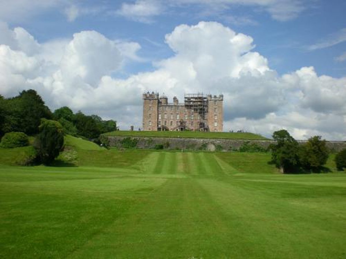
Drumlanrig Castle and its Outbuildings, Pavilion blocks, Balustrades, Quadrant Walls and Gardens Urns are all listed category A. The Castle was remodelled between 1679 and 1689 around a mid-16th century building which had been altered intermittently in the early 17th century. One of those alterations is reputed to be by Sir William Bruce. Robert Mylne probably provided the designs for the remodelling which was supervised by James Smith and built by William Lukup, the master-mason. The Castle, built around a square courtyard, has a turret at each corner. There were further alterations in 1813 by William Elliot. Other architects including Edward Blore, John Smallwood, Charles Barry, J. Laird and Sir Gilbert G. Scott were also involved. The Sundial by Thomas Wynne stands in the forecourt and the Coach House and Stables designed mostly by William Burn and William Atkinson between 1812 and 1830, are also included in this listing.
Drumlanrig Laundry, listed category B, was built in the early to mid-19th century, remodelled in about 1871 by Charles Howitt and converted into two cottages in 1924 by J. Laird of Glasgow. The Mains and Offices, listed category B, were built in the style of William Burn in the early 19th century and altered by J. Laird in 1924. The Mains Cottages, listed category C(S), were also built early in the 19th century.
Drumlanrig Bridge, listed category B, was probably late medieval, repaired by William Lukup in 1710, and widened in 1860 by Charles Howitt. Adjacent to it is the Bridge Cottage, listed category B, probably designed by William Burn in about 1840. Drumlanrig Creel Bridge, listed category B, was built early to mid-19th century out of slender cast-iron columns with iron stays and a timber walkway which has been renewed. This delicate structure, hanging over the ravine of the River Nith, is probably part of the 'picturesque' layout of W.S. Gilpin.
The Gardener's Cottage in the garden is listed category C(S) and was built in the mid- 19th century. Charles Howitt designed the Glasshouse near the cottage in about 1877 and it is listed category B. St Geoffrey's Bridge, listed category C(S), was built over the Marr Burn in the mid 19th century. The mid-19th century Summerhouse listed category B, is situated north of the Duchess Well and known as the Heather House. The rustic design is constructed out of split logs and twisted roots on an octagonal plan and decorated with hearts and crowns made out of shells and heather twisted into rope-like coils. There is a similar rustic Summerhouse lying to the south west of the Castle also listed category B. Another two of a similar date are situated in the woodlands across the Marr Burn. Plans for the Garden Cottage to the west of the kitchen garden were prepared by William Burn in 1831. The Kitchen Garden complex was built in the 19th century and contained several large ranges of glasshouses and other ancillary buildings, all of which have gone. The ruins of Tibbers Castle lie just to the east of the walled garden on the river bank. An Icehouse with an arched roof is completely buried on the east side of Bridgeknowe Loch.
Parkland
The park was laid out between 1810 and 1840 by the 4th and the 5th Dukes of Buccleuch. They were influenced by the ideas of Sir Walter Scott, who was a great friend of the 4th Duke. In 1833, in the Gardeners' Magazine, John C. Loudon wrote about 'the extensive improvements now carrying on in the grounds' and Alan Tait considers that these were probably after a scheme drawn up by William S. Gilpin whose plans for the flower garden were carried out.
The park lies to the east of the Castle and extends along the Nith valley, running northwards to Carse Wood, and south to Tibbers Castle. It crosses the river at Drumlanrig Bridge and runs up to Alison's Bank just below Holestane. Informal clumps and small copses were planted with mainly hardwood trees such as oak, beech, ash, and some lime. There are one or two majestic remnants of the 18th century planting, including a 300 year old sycamore which is the largest in Britain. These trees were saved from the mass felling ordered by the 4th Duke of Queensberry by concerned neighbours who bought the timber and left it growing. The magnificent avenue of limes lining a short part of the entrance drive was also saved. As many of these lime trees are now overmature, a programme of replanting the avenue was completed in 1978. Trees were planted inside the existing avenue but extending five times as far. Most of the remaining parkland trees are in their prime and, as the pastures are still grazed, they provide a perfect example of an early 19th century landscape park.
In the late 19th century, over 80 miles of driveways were recorded running through the park, policies and woodlands. These scenic drives were carefully laid out to view the picturesque qualities of the landscape and they can be seen on the 1st edition OS plan. One of these led to Duncan's Linn, which is a deep rocky gorge carved out by the River Nith. The Creel bridge spans the narrowest point overlooking the ravine and from it, there are dramatic views up and down the river. Narrow paths are cut out of the rock and run along either side of the gorge emphasising the awesome character of this natural ravine.
Woodland
Drumlanrig Wood lies along the steeper ground to the west of the Castle sheltering most of the park from the prevailing winds. The southern section was planted in the mid-17th century by the 1st Duke of Queensberry and added to when the formal gardens were laid out by the 3rd Duke. Most of the mature timber was felled by the 4th Duke in about 1810. Replanting began under the 3rd Duke of Buccleuch; Sir Walter Scott wrote in 1819 that Charles, the 4th Duke of Buccleuch, 'had already doubled the quantity of wood and the young plantations already begin to look beautiful'. Planting continued throughout the 19th century. Grass rides meandering through the plantations were commented on in gardening articles. Some of these lead to the rustic summerhouses which were illustrated in Charles McIntosh's influential book 'The Garden' published in 1853.
Walter, the 8th Duke, was recognised as an expert forester and undertook extensive replanting in the woods after World War II. Near the Castle, several fine hardwood specimens had been left as the plantations were cleared. In amongst these trees, conifers were planted and the Duke experimented by planting a wider range of varieties than were normally used in commercial forestry.
The Gardens
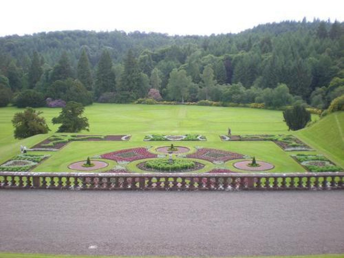
The gardens lie to the south of the Castle and the great terraces were cut out of the steep slope running down towards Marr Burn. The present framework of terraces connected by flights of steps and steep grass banks was laid out in 1738 by David Low, who was the gardener to the 3rd Duke of Queensberry. He overlaid his design on the terraces which could have been constructed by the 1st Earl in the mid-17th century. In 1720, Daniel Defoe described the gardens and wrote 'At the extent of the gardens there are pavillions and banqueting- houses,.... and the greens trimm'd, spalier and hedges are in perfection'. There is a 19th century copy of a plan showing David Low's garden with a detailed explanation of the layout. This is confirmed by an engraving of 'the Garden and Plantations' by John Roque published after 1739. This plan also shows the cascade tumbling down the hill opposite a fountain called Jock an' the Horn. The water fell into a canal at right angles to it, made from the Marr Burn. Both fell into disuse in the late 18th century but traces of the stone work can still be found on the ground.
The terraces on the east and west side of the Castle were restored by 1817 and the layout can be seen in an undated sketch plan. By about 1830, the full extent of the 19th century garden is shown on another unsigned plan, attributed by Tait to W.S. Gilpin. In 1840, Sir Charles Barry produced a fantastic plan for remodelling both the Castle and Gardens but it was not executed. Throughout the 19th century, these terraces were considered to be one of the 'foremost' gardens in the country. Articles extolling their layout and praising the complexity of the planting appeared regularly in gardening magazines and, in 1902, in Country Life. Some of the bedding out continued until just after World War II, when most of the terraces were grassed over. Recently two have been replanted.
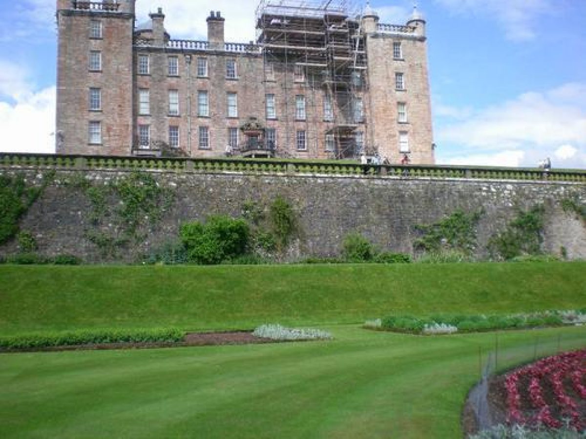
The entrance courtyard is enclosed by a stone wall and on either side of it are the Stables and other offices. The drive follows the oval lawn and the Castle entrance is reached by a double flight of curving steps, sweeping up to the first floor. On the south side, the Castle stands on a flat terrace supported by steep banks. Two narrow paths are cut into the front bank leading down to the second level. A wide path, which extends the entire width of the gardens, connects the large terraces on the east and west sides of the second level. The east parterre was known as the American Garden and was planted with heaths and heathers. It has recently been replanted to the 18th century design with lavender, box, and low conifers. The pattern of the west parterre's famous white sand garden can still be seen in the lawn. To the north and at a higher level lies the Duchess' Garden. It was a rose garden and is now planted with herbaceous borders and a herb garden. At its western end a tennis court and staff vegetable gardens have been added.
Beneath the high retaining wall, rebuilt in about 1830, three more terraces descend to the meadow running down to Marr Burn. The western one, called the Bowling Green, contains several very large yews, probably planted in the 18th century. It has two more diagonal grass paths cut into its eastern bank which lead down to the middle terrace. Known as the Shawl parterre, it has recently been replanted with a colour scheme of pink, grey, blue and white flowers and foliage. One of the first Maidenhair trees (Gingko biloba) to be planted in this country is trained against the high wall.
A broad ramp leads to Marr meadow where there used to be another huge parterre, shaped like the rays of the sun. Recently the pattern has been restored by mowing the grass to different heights. To the west lies the shrubbery planted with ornamental trees, including a large weeping beech, a large Abies albaand one of the Douglas firs which was raised from original seed sent by David Douglas, the explorer, to his brother, who was Master of Works at Drumlanrig. More recent planting includes a scarlet oak, making very rapid growth, planted by Neil Armstrong, the first man on the moon, and a Metasequoia, planted by the head of Forestry in China.
Criss-cross paths run down towards the Marr meadow and, in the 19th century, the steep bank was covered with clipped laurel, about 1.5m high. On the east side, the Pleasure Ground was almost certainly laid out by Gilpin. In the 19th century, his cloud shaped beds were interspersed with 'Rose Baskets' and some of the ironwork still remains today. The paths wind through the beech and oak woodland and lead to an adventure playground designed in 1977 by Lord Dalkeith. The glasshouse against the wall and next to the Gardener's cottage was built in 1877 and was restored 100 years later. It is still used to raise plants for the gardens.
Walled Garden
The walled kitchen garden was built in about 1830, probably at the same time as William Burn designed the Garden Cottage. Its flowers and produce were described in great detail in garden articles and the pine houses and grapes were particularly noted. In 1845 the kitchen garden contained over four acres growing vegetables, 200' of glass for vines and peaches, 100' of 'pine' stove, 100' of 'Dutch peach pits', 50' of succession peach houses, 100' of forcing frames and 50' of 'exotic' stoves. The extent of the glasshouses increased towards the end of the century and was considered in 1883 'to have few equals in this country'. All the glasshouses and ancillary buildings disintegrated between the World Wars, and the garden is now covered with grass. A corrugated iron shelter has been erected around the walls to protect cattle and sheep which over-winter in it.
- Visitor Access, Directions & Contacts
Telephone
01848 331555Access contact details
The gardens are open between April and September. Please see: http://www.drumlanrigcastle.co.uk/plan-a-visit/opening-times/
Directions
Drumlanrig can be reached by bus from Glasgow or Dumfries. For details see: http://www.drumlanrigcastle.co.uk/contact-us/find-us/
- History
The following is from the Historic Environment Scotland Gardens and Designed Landscapes Inventory. For the most up-to-date Inventory entry, please visit the Historic Environment Scotland website:
http://portal.historic-scotland.gov.uk/hes/web/f?p=PORTAL:DESIGNATIONS:0
Reason for Inclusion
One of Scotland's finest grand designed landscapes ' outstanding in every value ' with terraces and banks dating back to the 17th century and parterres restored to 1747 plans. The castle is listed category A, the stretch of the Nith River within the landscape is a Site of Special Scientific Interest, and as a whole, the site makes a major contribution to the surrounding scenery.
Main Phases of Landscape Development
No information available.
Site History
The terraces and banks could have been built originally in the 17th century, but the present layout was constructed in the mid-18th century. They were neglected throughout the later part of that century and were restored in the early 19th century at the same time as the policies were laid out and the kitchen garden was built. Almost all of the parterres were removed before World War II. Two are now being restored, one of them to the 1747 plan. The formal layout of the large meadow is picked out by mowing at different heights.
In the 14th century, the Douglas family were granted land in Nithsdale by King Robert the Bruce and they built their stronghold on the site of Drumlanrig Castle. This was largely rebuilt in the early 17th century by the 1st Earl of Queensberry and a note on a plan, dated 1618, suggests that this Castle could have been designed by William Bruce.
The Earl's grandson, William Douglas, was created the 1st Duke of Queensberry because of his services to the crown as Lord Justice General and Lord High Treasurer of Scotland. He remodelled the Castle between 1670 and 1690. James Smith, was entrusted to pay the 'Dutchmen', Peter Paul Boyse and Cornelius van Nerven, for work carried out at Drumlanrig.
James, the 2nd Duke, was one of the instigators and leading supporters of the Act of Union and it was his son Charles, the 3rd Duke who created the massive formal gardens shown on the plan drawn by John Roque. When he died in 1778, the property reverted to a second cousin, William, the 4th Duke. He used his unexpected fortune to support his extravagant lifestyle and in 1810, just before he died, most of the mature trees were felled to raise money. What he did not squander he left to his illegitimate daughter, and this financed the Wallace Collection.
Drumlanrig and some of the Queensberry titles passed through the female line to a distant cousin, Henry, who was already the 3rd Duke of Buccleuch and thus the two dukedoms were joined in one family. Both the 3rd Duke and his son began improving the neglected property. Walter Francis, the 5th Duke of Buccleuch, who succeeded in 1819, spent the next 65 years restoring the Castle and improving the grounds. Sir Walter Scott was a close family friend and stayed at Drumlanrig on several occasions. Between 1812 and 1840, William Atkinson, William Elliot, Edward Blore, William Burn, William S. Gilpin and Sir Charles Barry were all asked to produce designs for these improvements. During this period, Drumlanrig was made into one of the foremost designed landscapes in the country.
Under the care of Charles McIntosh, who wrote his influential books while employed as head gardener to the Duke, the great formal gardens with over nine parterres on as many banks, the Kitchen Garden with its great glasshouses and the 'picturesque' policies, became renowned. Many articles appeared in gardening magazines extolling the beauty and extent of the gardens and remarking on the range of fruit grown in the glasshouses.
Under William, 6th Duke of Buccleuch, (1884-1914), the gardens and grounds continued to flourish. Most of the huge parterres were removed before World War II and, by the end of the War, much of the woodland around Drumlanrig needed to be replanted. This great work was done by Walter, 8th Duke, (1935- 1973) who was an expert forester and greatly influenced current forestry techniques. His son John, 9th Duke, and his wife stepped up the pace of restoration and replanting. An avenue of lime trees was planted in 1978 along the whole length of the approach drive and the parkland knolls, which are an important landscape feature, have been mainly replanted.
- Associated People
- Features & Designations
Designations
Historic Environment Scotland An Inventory of Gardens and Designed Landscapes in Scotland
Site of Special Scientific Interest
- Reference: Part of the bank of the River Nith
Features
- Avenue
- Description: A grand double avenue of limes along the north drive. The outer trees date to the early-18th century and the inner ones were planted in 1977 to replace them.
- Cascade
- Description: A late-17th century cascade that was originally due south of the castle in woodland and flowed into the canalised Marr Burn. The area where it used to be is currently being cleared. It was supplied by an aqueduct two miles long, traces of which are visible in the woodland.
- Glasshouse
- Description: Originally a camellia house, this glasshouse has been restored from 2003 to 2007 and houses a variety of fruit and tender plants.
- Earliest Date:
- Latest Date:
- Rose Garden
- Description: The West Parterre is now a formal Rose Garden redug in 1990 to a 19th-century pattern. It was originally a 17th-century parterre with gravel walks and had several redesigns before being grassed over in World War 2.
- Parterre
- Description: The East Parterre was restored in 1978 to a 1738 plan after being grassed over during World War 2. A variety of tightly pruned evergreens mark out an elaborate scroll pattern. This design replaces an early-19th-century American Garden on the site.
- Parterre
- Description: The Shawl or High White Sand Garden was a famed heather garden in the early-19th century but its planting was simplified after World War 2 although the layout remains. A variety of plants and coloured gravel form scrolls and family crests.
- Garden Terrace
- Description: The Long Terrace Walk under the Castle is 183 metres long and has an exceptionally high retaining wall.
- Summerhouse
- Description: A rustic summerhouse similar to the Heather House.
- Summerhouse
- Description: The Heather House is a rustic summerhouse constructed from birch and larch and finished off inside with heather and moss. It has recently been restored.
- Earliest Date:
- Latest Date:
- Castle (featured building)
- Description: The 1679 remodelling incorporated a mid-16th-century core.
- Earliest Date:
- Latest Date:
- Key Information
Type
Estate
Purpose
Ornamental
Principal Building
Domestic / Residential
Survival
Extant
Hectares
1982
Open to the public
Yes
- References
References
-
Historic Scotland, 'Drumlanrig Castle', {Gardens and Designed Landscapes},
Contributors
Historic Scotland
-
Historic Scotland, 'Drumlanrig Castle', {Gardens and Designed Landscapes},