
Introduction
Originating in the medieval period, the estate was laid out as a landscape park with woodland in the mid-18th century. The site covers about 200 hectares, and now contains two golf courses.
Terrain
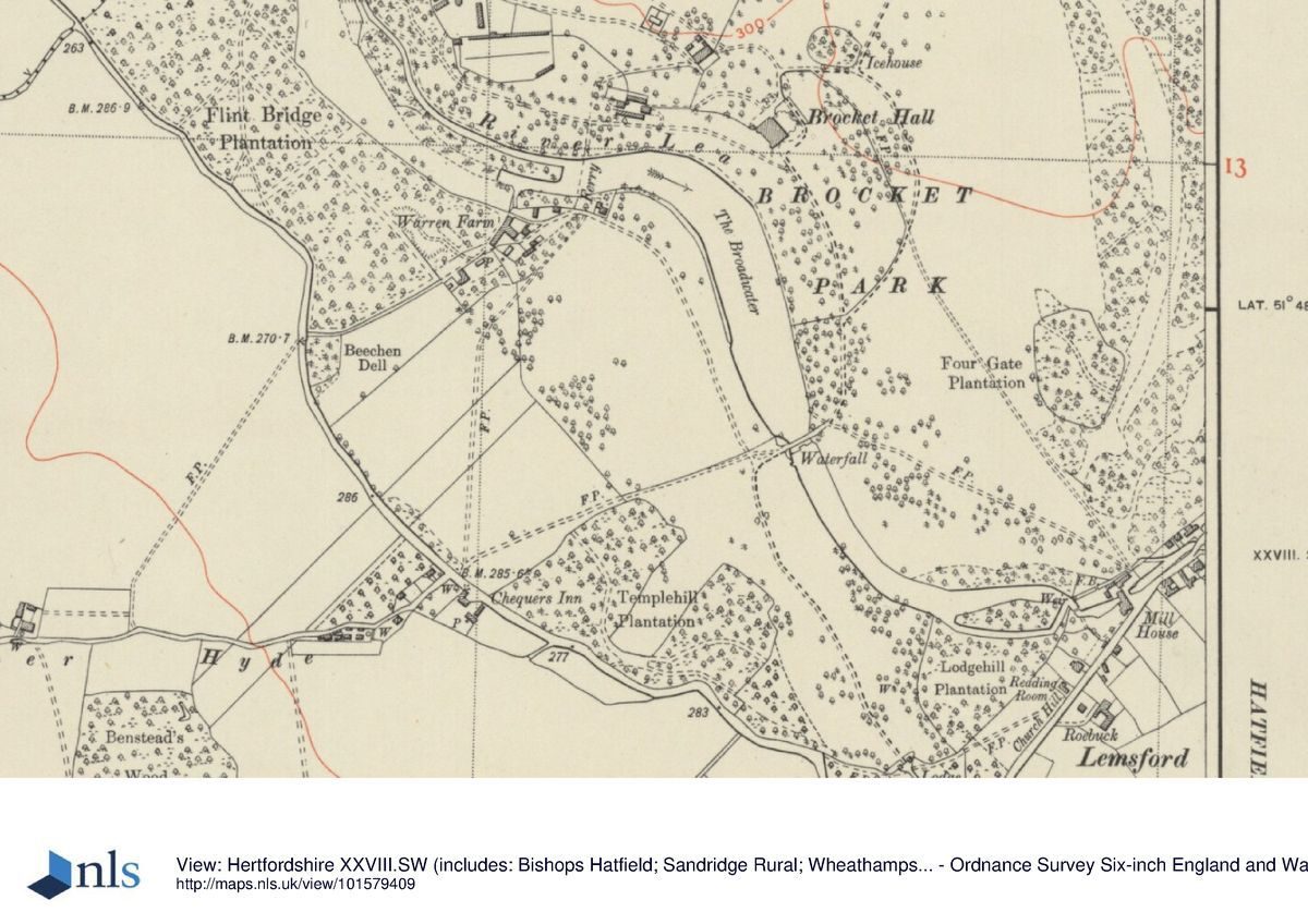
The ground slopes generally south-westwards down to the course of the River Lea, incorporating The Broadwater, which flows south across the estate.www.historicengland.org.uk/listing/the-list
A mid-18th-century landscape park remodelled by Richard Woods, around 1770, surrounding an 18th-century country house.
DESCRIPTIONLOCATION, AREA, BOUNDARIES, LANDFORM, SETTING
Brocket Hall lies at the west edge of Welwyn Garden City, from which it is separated by the late C20 A1(M) motorway, between the village of Lemsford to the south and the hamlet of Ayot Green to the north. The c 200ha site is bounded to the east by the A1(M) motorway, the road occupying the site of a strip of former park woodland which lay adjacent to the former east boundary. This strip was itself bounded by the Great North Road which lies immediately to the east of the motorway. The other boundaries are largely marked by agricultural land and woodland, with the south-west boundary formed partly by the B653 Hatfield to Wheathampstead road, and the south-east boundary partly adjoining Lemsford. The ground slopes generally south-westwards down to the course of the River Lea, incorporating The Broadwater, which flows south across the estate. South-west of the Lea the ground rises again. The setting is partly rural, with, beyond the busy motorway, the extensive C20 development of Welwyn Garden City.
ENTRANCES AND APPROACHES
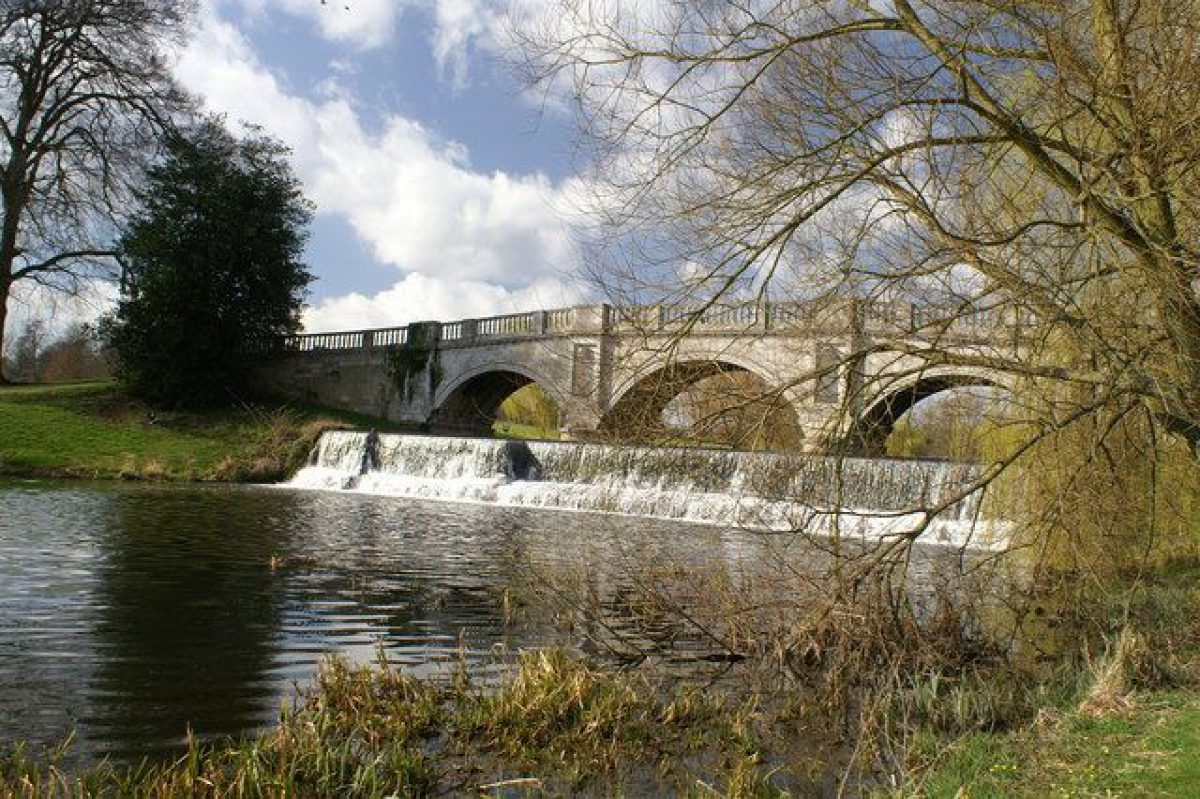
The main approach to the park is from the south, via the south drive, which leaves the B653 c 1km south-south-east of the Hall, at the junction with Church Hill. The drive extends north-west for 150m, flanked by lawns, these in turn flanked by the remains of a cedar avenue, to reach a gateway guarded by lodges (James Paine c 1765, listed grade II*) standing 900m south of the Hall. The two-storey, red-brick lodges are ornamented with stone dressings and are flanked by screen walls. The central gates repeat a semicircle motif found on the lodges. From here the drive curves north-west, overlooking the Hall to the north, before turning north-east 450m south of the Hall to cross The Broadwater, carried by James Paine's stone bridge (1772-4, listed grade II*) which is itself overlooked by the Hall to the north. From the bridge the drive curves north up a gentle rise to arrive at a carriage sweep on the south-east front. From here a spur curves northwards, east of the Hall, to give access to a service entrance on the north-west side of the Hall, and the stable block standing c 125m north-west of the Hall. A further spur leaves the south drive 250m south of the Hall, continuing north to the east of the Hall in a wide arc, to join the service drive to the stables 50m north of the Hall.
A further approach, via Ayot Green, enters 900m north-north-east of the Hall, guarded by two red-brick, square-plan lodges and four large gate piers (James Paine c 1750s, listed grade II) flanking the drive. From here the north drive extends south-south-west through woodland, before emerging into parkland 400m from the Hall. The drive joins the outer spur of the south drive 150m north-east of the Hall.
A network of further paths and drives overlies the park.
PRINCIPAL BUILDING
Brocket Hall (James Paine c 1760-80, listed grade I) stands at the centre of the park, on an eminence, overlooking much of the parkland including The Broadwater below to the west and south. The three-storey, red-brick Hall is a piecemeal reconstruction of an older courtyard house, rebuilt for Sir Matthew Lamb and his son Sir Pennistone Lamb.
The stable block (James Paine c 1750s, converted to hotel use 1987, listed grade II) stands c 125m north-west of the Hall, the two-storey, red-brick block having been built for Sir Matthew Lamb. Some 175m west of the Hall stands a group of buildings enclosing three sides of a courtyard, including the former laundry house and laundry block (both probably James Paine mid(late C18, listed grade II). The laundry block has been converted into a golf clubhouse. The former stables and laundry buildings are prominent in views within the parkland.
GARDENS AND PLEASURE GROUNDS
The pleasure grounds extend north-west from the Hall in a sinuous band, sweeping down to the northern section of The Broadwater and, north of this, the narrower course of the River Lea. The pleasure grounds are laid largely to lawn with scattered mature specimen trees, including cedars of Lebanon. A path runs north-west from the Hall to the edge of the pleasure grounds and the Flint Bridge standing on the northern boundary, 750m north-west of the Hall.
Some 200m west of the Hall, at the east side of the former laundry complex, stands The Temple (probably James Paine mid(late C18, listed grade II*), a brick and stucco, single-storey building with an elliptical porch and a marble basin said to have been used for taking syllabub. The Temple overlooks the park and Broadwater to the south.
The pleasure grounds were laid out initially in the mid C18 as parkland with many clumps of trees and singles, being remodelled as a pleasure circuit with a waterside walk as part of Woods' campaign of the 1770s (estate plan, 1752; Pallett, 1798).
PARK
The park surrounds the Hall which is set in open parkland with the remains of scattered parkland trees. The parkland is now (1999) largely overlain by golf courses and is bounded by substantial woodland belts. The park is dominated by, and divided into two sections, by the River Lea, which enters the park via the Flint Bridge in Bluebell Hill Wood 750m north-west of the Hall, leaving again 800m south-east of the Hall. The river is substantially enlarged southwards from 300m west of the Hall for c 1km, to form the sinuous Broadwater, which is overlooked by the Hall and parkland which rises to either side of it. The Broadwater had been created by the mid C18, it being remodelled and enlarged in places by Woods during the 1770s to accommodate Paine's three-arched stone bridge carrying the south drive (estate plan, 1752; Pallett, 1798).
A broad avenue begins c 450m south-west of the Hall (on which it is aligned), extending a further 350m south-west to the B653. The avenue is separated from the road by wrought-iron gates and a flanking screen set on a low brick wall (1935, the whole listed grade II) on the east side of the road, and extends for a further 400m beyond the B653, terminating at Benstead's Wood (the woodland being outside the area here registered). Views extend north-east along the avenue to the south-west front of the Hall, which is framed by woodland to the north-east, The Broadwater being invisible from the gates and screen, and from the south-western half of the avenue. The avenue was laid out in the early C20 (OS 1899; 1923), and the gates and screen erected in the mid 1930s by the second Lord Brocket in memory of his parents.
The park retains traces of the mid C18 layout, and much evidence of Woods' improvements of the 1770s, and seems to have been little altered in the C19. The woodland blocks present in the late C18 (Pallett, 1798) have, however, gradually been considerably enlarged and some have merged as a result.
An icehouse formerly stood 150m north-east of the Hall, in a clump of trees (OS 1898).
KITCHEN GARDEN
The walled kitchen gardens (probably James Paine or Richard Woods, mid(late C18, listed grade II) lie 300m north-west of the Hall. They are divided into several sections, together with an attached gardener's cottage and octagonal, early C19 glasshouse and other service buildings and glasshouses. An earlier kitchen garden lay to the north of the stables (estate map, 1752).
REFERENCES
Chauncy, Historical Antiquities of Hertfordshire (1700)
Angus, Seats of the Nobility ... (1787)
Copperplate Magazine 2, (1793(4), plate 76
Victoria History of the County of Hertfordshire 3, (1912), pp 101-2
Country Life, 58 (4 July 1925), pp 16-22; (18 July 1925), pp 96-103
P Willis, Charles Bridgeman (1977), pp 87, 177-8
J Harris, The Artist and the Country House (1979), p 294
Garden History 15, no 1 (Spring 1987), pp 31-4
Brocket Hall Development Strategy, (Cass Associates 1991)
Maps
C Bridgeman, Brocket Hall, around 1731-8 (Gough Collection, Bodleian Library, Oxford)
Plan of Brocket Hall, 1752 (Hertfordshire Record Office)
Dury and Andrews, A topographical Map of Hartford-shire, 1766
T Pallett, Survey and Plan of Brocket Hall Park, 1798 (Hertfordshire Record Office)
OS Surveyor's Drawing, 1810
OS 6" to 1 mile: 1st edition 1881; 2nd edition 1899; 3rd edition 1923
OS 25" to 1 mile: 2nd edition published 1898; 3rd edition 1924
Description written: January 2000
Amended: October 2000
Edited: November 2000
- Visitor Access, Directions & Contacts
Telephone
01707 368700Website
https://brocket-hall.co.ukAccess contact details
http://www.brocket-hall.co.uk/
Directions
West of Welwyn, north of the B653
Owners
Brocket Hall International Ltd
- History
The following is from the Register of Parks and Gardens of Special Historic Interest. For the most up-to-date Register entry, please visit the The National Heritage List for England (NHLE):
www.historicengland.org.uk/listing/the-list
HISTORIC DEVELOPMENT
In 1700 the Brocket estate was described thus: 'Brocket Hall was the ancient seat of the Brockets situated upon a dry hill in a fair park, well wooded and greatly timber'd enclosed with a brick wall on the west side of the road for the length of a mile and plentifully watered with the River Lea' (Chauncy 1700). Charles Bridgeman (died 1738) produced surveys in the 1730s and made proposals which were not implemented (Bodleian Library).
In 1746 Matthew Lamb (1705-68) bought Brocket Hall from the estate of Thomas Winnington (died 1746). A plan of 1752 (Hertfordshire Records Office) shows that the old manor house or Hall stood to the north of an adjoining walled garden containing serpentine paths, set in extensive parkland. The park was laid out with a belt, many copses, clumps and specimen trees, and a lake which was formed from the widened River Lea. The bulbous southern end of the lake was embellished with a curlicue which concealed the dam. Upon Lamb's death his son, Sir Pennistone Lamb (1748-1819, created Baron Melbourne 1770, Viscount Melbourne 1781), inherited the estate, continuing works previously started by his father, including the rebuilding of the Hall by James Paine (begun in about 1760). Richard Woods was employed from 1770 to improve the setting of Paine's Hall within the park, but there is no known plan by Woods. In 1787 Angus noted how 'The Water and Out-grounds were laid out and disposed by Mr Woods of Essex in the most luxuriant and masterly Manner'. Woods appears to have been employed at Brocket Park until 1774, and his completed work is shown on a plan of 1798 (HRO). He modified the planting and widened the existing water body into a larger lake which extended the length of the park, altering the water level to accommodate a bridge previously built by Paine. A new approach drive was also created, carried across the stately new sheet of water by this imposing bridge. Woods also probably moved the kitchen garden to its present position and carried out work connected with the shrubbery, pleasure grounds, new dairy, hothouse and pinery, which is recorded in estate account books (Garden History 1987).
The estate continued in the Lamb family during the 19th century, passing to William Francis Cowper (created Baron Mount Temple 1880) upon the death of his mother, Emily Lamb (1787-1869), who had married first the fifth Earl Cowper (died 1837) and second, in 1839, the third Viscount Palmerston (prime minister 1855-8, 1859-65). The estate was sold to the present (1999) Lord Brocket's family in 1922 and remains partly in private ownership, the Hall being used for corporate entertainment, with much of the parkland overlain by golf courses.
- Associated People
- Features & Designations
Designations
The National Heritage List for England: Register of Parks and Gardens
- Reference: GD1524
- Grade: II
Style
English Landscape Garden
Features
- Palladian Bridge
- Hall (featured building)
- Description: Sir Pennistone Lamb (1748-1819), inherited the estate, continuing works previously started by his father, including the rebuilding of the Hall by James Paine (begun in about 1760).
- Earliest Date:
- Latest Date:
- Kitchen Garden
- Earliest Date:
- Lake
- Parkland
- Woodland
- Golf Course
- Key Information
Type
Park
Purpose
Recreational/sport
Principal Building
Commercial
Survival
Part: ground/below ground level remains
Hectares
200
Open to the public
Yes
Civil Parish
Hatfield
- References
References
- {English Heritage Register of Parks and Gardens of Special Historic Interest}, (Swindon: English Heritage, 2008) [on CD-ROM] Historic England Register of Parks and Gardens of Special Historic Interest
- Willis, P., {Charles Bridgeman and the English Landscape Garden} (London: Zwemmer, 1977), pp. 87, 177-8 Charles Bridgeman and the English Landscape Garden
- Harris, J., {The Artist and the Country House} (London: Russell Chambers, 1979), p. 294 The Artist and the Country House
- Page, W. {Victoria County History: Hertford, Volume 3} ([n.p.]: [n.pub.], 1912), pp. 101-2 Victoria County History: Hertford, Volume 3