Introduction
The Hoo has the remains of an 18th-century landscape park with work by Lancelot Brown and William Chambers. The house was demolished and much of the estate returned to agriculture in the mid-20th century.
Terrain
The Hoo estate overlies low rolling hills at the northern end of the Chiltern range. The site of the former house occupies a plateau towards the centre of the estate, overlooking much of the surrounding park which drops away to the east and north.www.historicengland.org.uk/listing/the-list
An C18 landscape park, formerly surrounding a C17/C18 country house (demolished 1958), with work by Lancelot Brown c 1760-2.
DESCRIPTION
LOCATION, AREA, BOUNDARIES, LANDFORM, SETTING
The Hoo estate overlies low rolling hills at the northern end of the Chiltern range between Luton and Stevenage, lying 1.5km north-east of the village of Kimpton and 2km south of the village of St Paul's Walden. The c 120ha estate is bounded to the east by the lane connecting Whitwell with Codicote, the boundary being marked by occasional short lengths of a brick and flint former boundary wall lying adjacent to the road, and on the other sides by open agricultural land. The site of the former house occupies a plateau towards the centre of the estate, overlooking much of the surrounding park which drops away to the east and north. From the valley which the eastern boundary occupies, the land rises eastwards up a hillside which draws views from the eastern half of the park and the site of the house. The setting is rural, with views from the house site to the south, east and to the north, particularly towards St Paul's Walden Bury (qv) some c 2km away.
ENTRANCES AND APPROACHES
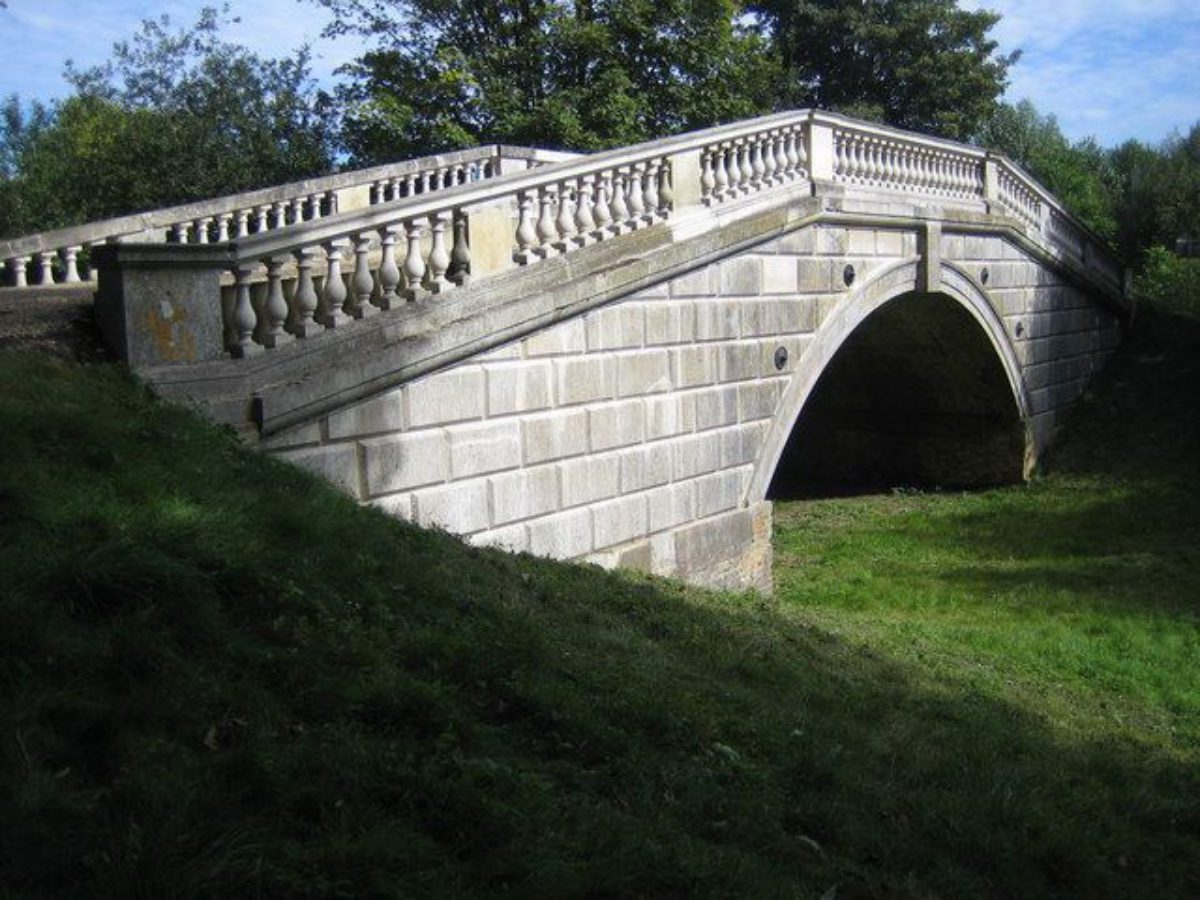
The main approach, via the south-east drive, enters the site 750m east of the site of the former house, off the Whitwell to Codicote lane, the entrance formerly marked by a lodge (OS; gone 1999). The drive curves south-west upon a raised bank or causeway which appears to have formed the dam between the northern and southern sections of the former lake, the site of which extends north along the valley from the drive, running parallel with the east boundary. Some 600m south-east of the site of the house, the drive is carried across the southern outlet of the diverted arm of the River Mimram, at the outlet of the former lake, by a single, round-arched bridge (Sir William Chambers c 1764, scheduled ancient monument, listed grade II). Built of brick, the bridge is clad in Portland stone but has lost its balustrade. From the hump-backed top of the bridge views extend north and south, up and down the Mimram valley. From here the drive ascends north-west through the park, with views extending south and north-east to the surrounding countryside. The drive arrives at the gated entrance to a gravel courtyard, having formerly opened out into a courtyard on the main, east front of the former house. The gateway now (1999) gives access to a gravel court on which stands the stable block/coach house, to the north of the site of the former house, flanked to north and south by several 1990s houses.
The north-east drive enters 800m north-east of the site of the former house, off the Whitwell to Codicote lane, the entrance marked by Hoo Farm Lodge (C18, listed grade II). This two-storey cottage, of white-painted brick and stucco, has a prominent, large, round-arched recess on the wall overlooking the drive, facing Hoo Farm to the south. From here the drive curves south-west, ascending to the plateau on which stands the site of the former house. The drive turns south c 300m north of the site of the former house, continuing along the east side of Round Wood before opening out into the gravel courtyard which lies on the east side of the group of recent houses flanking the old stable block/coach house.
The west drive gives direct access from Kimpton, passing the single-storey, brick and flint Hoo Lodge situated 1.5km south-west of the site of the former house, set back off the B651 Kimpton to Whitwell lane. The drive extends north-east across open agricultural land (outside the registered area), ascending the hillside to the C20, single-storey, rendered Hoo Park Cottage, dated 1902. From here the drive (from this point on within the registered area) continues north-east through parkland, flanked by an informal avenue of mixed species and ages, the oldest specimens being large sweet chestnuts and younger specimens being of oak and lime. The avenue finishes at the west corner of Round Wood, with the west drive skirting the north side of the Wood before joining the north-east drive at the north-east corner, 200m north of the site of the former house.
Prior to Brown's work of the 1760s, the main drive approached straight off the lane to the east, aligned on the east front of the house from which it was separated by an enclosed forecourt, and flanked by an avenue of trees (estate map, early-mid C18).
PRINCIPAL BUILDING
The manor house (demolished 1958) lay in the western half of the park. Rebuilt c 1661 by Sir Jonathan Keate, it was remodelled by Sir William Chambers for Thomas Brand in the 1760s. By the late C19 (OS 1884) its main entrance on the east front was elevated on a balustraded terrace overlooking the gravel forecourt. The south and west fronts overlooked the gardens, and a service wing extended from the north front towards the stables/coach house. The site of the house is now (1999) partially covered by two 1990s houses and their gardens.
The two-storey brick stable block/coach house (C18, possibly by Sir William Chambers, listed grade II), which stands to the north of the site of the former service wing of the house, has been converted for domestic use. The central block, flanked by single-storey aisles, is entered from the forecourt to the east via three large, arched doorways for coaches.
GARDENS AND PLEASURE GROUNDS
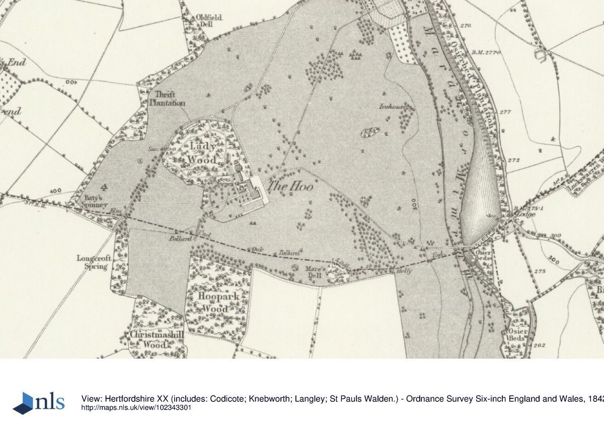
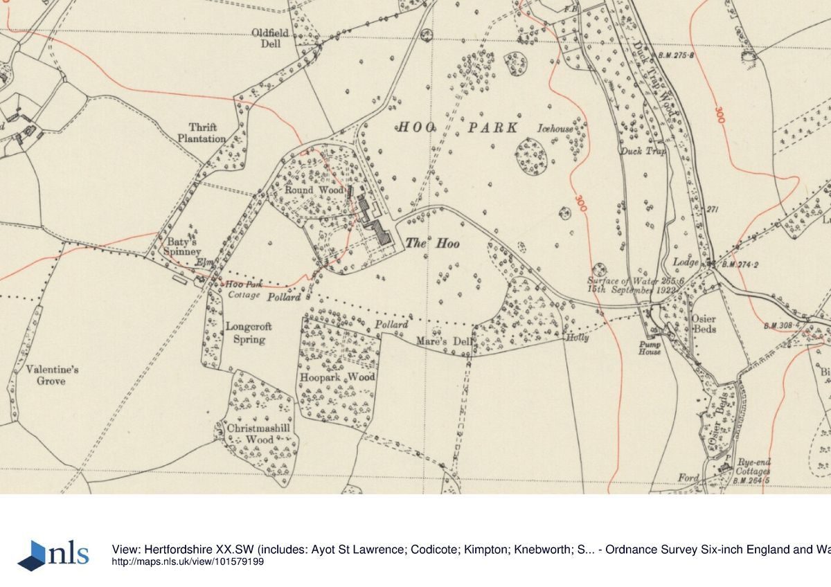
The remains of the garden and pleasure grounds attached to the former house lie adjacent to the west of the stables and recent dwellings, the area being divided into gardens attached to the dwellings. The informal area is largely laid to lawn, with several large, mature trees, including sweet chestnuts and cedars, lying towards the western boundary. No visible trace of earlier garden features appears to survive. Long views extend south from the south side of the plateau on which the garden lies, towards a range of distant hills. To the north of the garden lies Round Wood (formerly known as Lady Wood, OS C19), an area of former pleasure grounds recently (late C20) replanted with conifers and underplanted with evergreen shrubs including laurel.
Prior to Brown's work of the 1760s, two formal garden compartments extended from the south front of the house, including a bowling green. One small formal garden compartment lay adjacent to the west front (estate map, early-mid C18). In the late C19 and early C20 (OS) the garden surrounded the former house to the south and west, with a formal system of paths enclosing panels of lawn close to the house, leading to less formal areas towards the north and west edges of the garden. At this time Lady Wood, an area of mixed woodland, contained a network of paths which have since disappeared.
PARK
The park surrounds the garden and site of the former house and is laid largely to pasture with some arable, areas of woodland being mainly sited around the perimeter. From the site of the house the park, containing clumps of trees and scattered singles, slopes east down towards the eastern boundary. Some 500m north-east of the site of the house lies the brick-built icehouse (C18, listed grade II), sunk into a promontory overlooking the valley to the east, with its dome exposed and having lost its approach tunnel on the east side. East of this promontory the ground slopes more steeply down to the valley, reaching first the western arm of the River Mimram, and beyond this the site of the former lake, formed by Lancelot Brown c 1760-2 by diverting the river into an eastern course. The site of the lake was partly filled in during the C20 and trees planted over much of the area. The two water courses join south of Chambers' bridge at the southern end of the former lake, continuing southwards through an area of seemingly short-lived former parkland (OS 1884). A path formerly led north-east across the parkland from close to the west end of the south-east drive, giving direct access from the house to the west side of the walled garden at the north-east corner of the park.
West of the pleasure grounds, adjacent to the informal avenue flanking the west drive, lies a cricket pitch and pavilion. To the south of this lie the woodland areas of Longcroft Spring, Christmashill Wood and Hoopark Wood.
North of the north-east drive lies an area of the park which covers a steep-sided valley; this contains Oldfield Plantation and, to the west of this, a large, mature cedar of Lebanon. Views extend from the park in many directions.
Before Brown's work of the 1760s, the much smaller park lay adjacent to the gardens, to the west and south of the house, with Round Wood adjacent to the north-west (estate map, early-mid C18).
KITCHEN GARDEN
The brick-walled kitchen garden, largely laid to lawn, lies towards the north-east corner of the site and consists of an inner brick-walled compartment bounded to the west and south by a further, outer compartment, itself walled to the south and west (the walls being C17 and listed grade II). The outer compartment is entered from the park via a stone doorcase set at the centre of the south-west wall, with a further opening aligned with this doorway set into the dividing wall between the two compartments. Formerly (OS C19) a path crossed the park from c 75m north-east of the former house, leading north-east from the south-east drive to the stone doorway in the outer brick wall.
The north-west boundary of the area is largely formed by farm buildings including the brick Hoo Farmhouse (C17 and later, listed grade II).
REFERENCES
Chauncy, Historical Antiquities of Hertfordshire (1700), p 510
C Campbell, Vitruvius Britannicus IV, (1725), pl 18
Royal Institute of British Architects, Catalogue vol B, (1972), p 113
D Stroud, Capability Brown (1975), pp 229-30, pl 34a
B Cherry and N Pevsner, The Buildings of England: Hertfordshire (1977), pp 330-1
Country Life, 165 (19 April 1979), p 1178
Maps
Survey of the Manors of Legats, Parkbury, ... situate in the Parishes of Kimpton and St Paul's Walden, early-mid C18 (40443), (Hertfordshire Record Office)
Dury and Andrews, A topographical Map of Hartford-shire, 1766
OS 6" to 1 mile:
1st edition published 1884
2nd edition published 1899
OS 25" to 1 mile: 2nd edition published 1898
Description written: February 1999 Amended: October 2000
Register Inspector: SR
Edited: November 2000
The following material was contributed by Hertfordshire Gardens Trust:
Statement of Significance
The Hoo at Kimpton was landscaped from an earlier formal style following a payment of £150 to Lancelot Brown, in 1758. William Chambers and Brown supplied designs for a bridge on the entrance drive, and the Chambers' was built (restored 2004). A lake, sinuous drives, woodland belts and ornamental woodland walks were laid out at this time. Although the house has been replaced with several smaller houses, much of the land remains agricultural and historic views towards St Paul's Walden and the surrounding countryside are extant in part.
Additional Sources of Information
Campbell, C., Vitruvius Britanncius IV (1725), pl 18
Chauncy, H Historical Antiquities of Hertfordshire (1700) p.150 (including illustration by J Drapentier)
Clutterbuck, R History of Hertfordshire vol VIII. p70 A-C Views of house and environs By J C Buckler 1832 [N.B. illustrations in Knowsley Cluterbuck only]
Country Life, 165 (19 April 1979), p1187
Leiper, H. ‘Mr Lancelot Brown and his Hertfordshire Clients' In: Hertfordshire Garden History Volume II: Gardens pleasant, groves delicious (Spring, D. ed) (University of Hertfordshire Press, 2012) pp92-120
Prince, H., Parks in Hertfordshire since 1500 (2008, University of Hertfordshire Press)
Prince, H., ‘Land use and landownership: a recent history of parks in Hertfordshire In: Landscape History 31 (1) 2010 pp 53-72
Royal British Institute of Architects, Catalogue vol B, (1972), p113
Turner, R., Capability Brown and the Eighteenth-century Landscape (1999, Phillimore), P182
Willis, P., ‘Capability Brown's Account with Drummond's Bank 1753-1783' In: Architectural History, Vol. 27, Design and Practice in British Architecture: Studies in Architectural History Presented to Howard Colvin (1984), pp. 382- 391
McManus, P, Constable, A The Hoo, Kimpton (2005 unpublished research report for Hertfordshire Gardens Trust)
Hertfordshire Archives and Local Studies (HALS)Views:
KIM/9 The Hoo, seat of Honble Thomas brand Watercolour by an unknown artist, n.d. showing landscaped park
KIM/10 West and South fronts of Kimpton Hoo, JP Neale 1829
D/EBg/4 p 169 View of Kimpton from the Park by J C Buckler 1840
Maps and Plans:
40443 Survey of the Manors of Legats, Parkbury,' ‘ ‘ situate in the Parishes of Kimpton and St Paul's Walden, early-mid C18 Ordnance Survey Drawing 1805
Dury and Andrews, A Topographical Map of Hartford-shire, 1766
Ordnance Survey Drawing 1805
Bryant, A., The County of Hertford from an actual Survey in the Years 1820 and 182, 1822
Ordnance Survey 1st Edition, 1884, Sheet XX, 6" to 1 mile
Ordnance Survey 2nd Edition, 1899 Sheet XX, 6": 1 mile
Ordnance Survey 2nd Edition, 1898 25":1 mile
Ordnance Survey, Sheet XX.SW, 1950 6":1 mile
NB. No map or plan by L Brown is known.
- Visitor Access, Directions & Contacts
- History
The following is from the Register of Parks and Gardens of Special Historic Interest. For the most up-to-date Register entry, please visit the The National Heritage List for England (NHLE):
www.historicengland.org.uk/listing/the-list
HISTORIC DEVELOPMENT
The manor of Hoo was held by the Hoo family from the C13. Thomas Hoo died in 1650, the manor passing to his daughter Susannah and her husband Sir Jonathan Keate, an alderman of London who became Sheriff of Hertfordshire. The Hoo manor house was rebuilt during the mid C17. Sir Henry Hoo Keate sold the manor in 1732 to Margaret Brand, who was succeeded by her son, Thomas, who employed the landscaper Lancelot Brown (1716-83) and the architect Sir William Chambers (1723-96) to embellish the landscape during the 1760s. An undated estate map of the early to mid C18 (HRO) shows a formal approach and garden enclosures, with a small park, surrounding the house prior to Brown's alterations. Upon Thomas Brand's death in 1770 the estate passed through the family, descending with the title of Lord Dacre, the twenty-third Lord Dacre being elevated to Viscount Hampden in 1884. The third Viscount Hampden sold the estate in 1938, it being subsequently in divided ownership. The house was demolished in 1958, a group of several new houses being erected on the site during the 1990s.
The following material was contributed by Hertfordshire Gardens Trust:
The 1776 Dury and Andrews map, completed after improvements, show an extensive squarish park with an area of ornamental shrubbery or woodlands at its heart, (the former Thrift Wood) laid out with serpentine paths. Some trees remained from the previous landscape of hedgerows. A new drive was laid out approaching the house from the south-west, and secondary drives or rides included a drive to the south-east which crosses the river Mimram over the Chambers bridge. This river had been dammed and widened by 1766 to form a broad water, with a Lodge at the southern and between the bridge and the public road. A walled garden, unrecorded before 1766, was situated in the north-east corner of the park.
By 1822 as depicted on the Bryant map, the park had been extended south along the west bank of the Mimram as far as the Kimpton public road, enclosing Rye-House farmhouse, which was then screened from the mansion by a block of woodland. A perimeter belt of trees was planted along the east side of the park to screen it from the public road and other sinuous belts around the parkland. By 1844 the parkland was beginning to be returned to fields and the walled garden enlarged with an orchard to the south. South of that a small ice-house was recorded.
By the end of the 19th century, formal, though simple gardens were laid out around the house, with a large conservatory or glasshouse adjacent. The adjoining Lady's Wood was laid out with serpentine paths and the parkland had shrunk in area. The return to farmland continued and by the mid-20th century, had become a small area around the house, but still with some clumps and standards, the lake had been drained but the paths in the wood (named Thrift, then Lady, then Round) survived. Much of the former parkland remains in the ownership of Oxford University who purchased it in 1938.
Detailed text last amended 05/10/2013
Period
18th Century (1701 to 1800)
- Associated People
- Features & Designations
Designations
The National Heritage List for England: Register of Parks and Gardens
- Reference: GD1909
- Grade: II
Green Belt
- Reference: Southern half only
Features
- House (featured building)
- Now Demolished
- Description: The mid-17th century house was demolished in 1958.
- Earliest Date:
- Latest Date:
- Boundary Wall
- Description: Occasional short lengths of a brick and flint former boundary wall.
- Ornamental Bridge
- Description: Bridge over the river Mimram.
- Kitchen Garden
- Description: North-east corner, at Hoo Farm, walls partially demolished.
- Parkland
- Key Information
Type
Park
Purpose
Agriculture And Subsistence
Period
18th Century (1701 to 1800)
Survival
Part: standing remains
Hectares
120
Open to the public
Yes
Civil Parish
Kimpton
- References
References
- {English Heritage Register of Parks and Gardens of Special Historic Interest}, (Swindon: English Heritage, 2008) [on CD-ROM] Historic England Register of Parks and Gardens of Special Historic Interest
- Stroud, D., {Capability Brown} (London: Faber, 1975), pp. 229-30, plate 34a Capability Brown
- Turner, R. {Capability Brown and the Eighteenth-century English Landscape} (Phillimore, 1999) 182 Capability Brown and the Eighteenth-century English Landscape
- Pevsner, N. and B. Cherry, {The Buildings of England: Hertfordshire} (Harmondsworth: Penguin, 1977), p. 330-1 The Buildings of England: Hertfordshire