Introduction
This is a late-18th century private square covering about 1 hectare, laid out between 1775-1780, most probably to a design of Thomas Leverson.
Terrain
Level.www.historicengland.org.uk/listing/the-list
Late 18th century private square, forming part of the Bedford Estate, re-landscaped in the 1870s.
LOCATION, AREA, BOUNDARIES, LANDFORM, SETTING
Bedford Square, 1ha, is located to the east of Tottenham Court Road and west of the British Museum, in Bloomsbury. The garden, which is on level ground, is enclosed by late C18 cast-iron railings with spearhead finials (listed grade II with the gates). The gardens and railings, both in an oval shape, are surrounded by the buildings of the Square, which are on a rectangular plan. Gower Street and Bloomsbury Street run down the east side of the Square. Bayley Street runs east/west from the north-west corner of the Square, connecting it to Tottenham Court Road.
ENTRANCES AND APPROACHES
There are entrances to the gardens on the north and south sides through late C18 gates with wrought-iron overthrows (listed grade II with the railings).
GARDENS AND PLEASURE GROUNDS
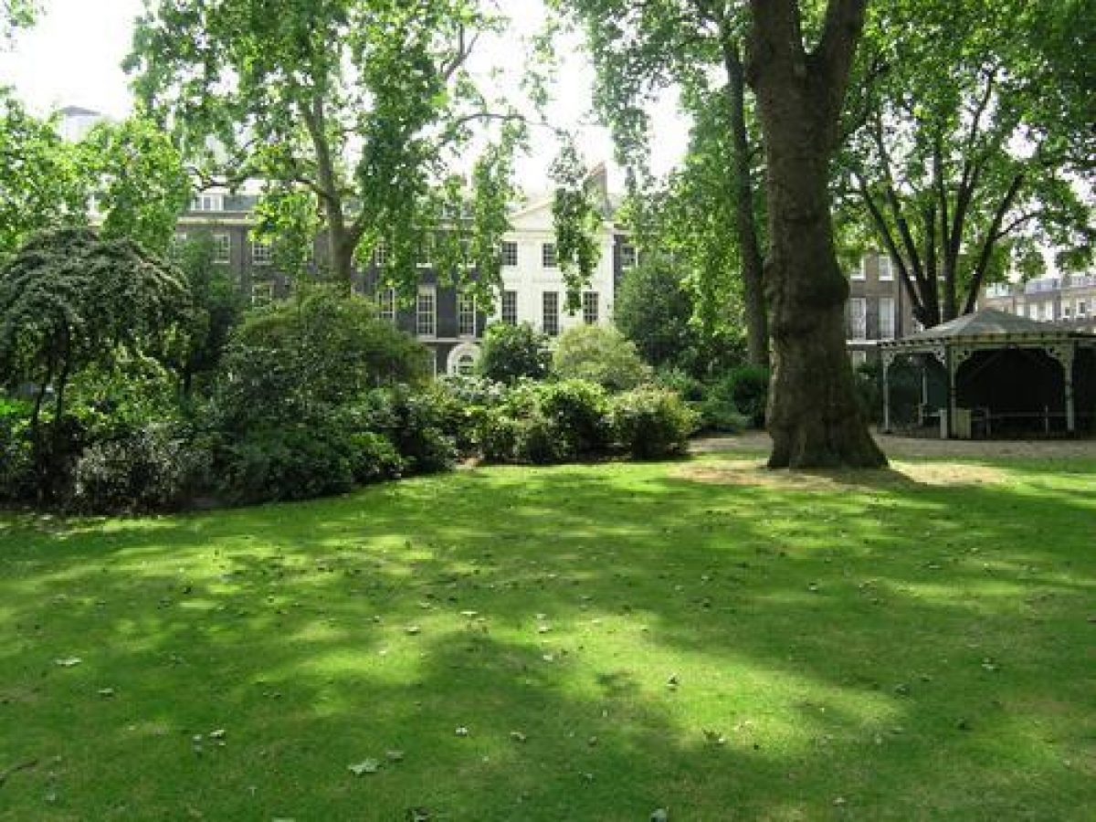
The centre of the gardens consists of an oval of lawn surrounded by a perimeter path. Between the perimeter path and the railings there are shrubberies, punctuated by small areas of grass, each set with a mature plane tree. Opposite these grassy openings are internal shrub groups on the inner side of the perimeter path. These maintain privacy but because all the shrubbery groups are pierced, views can be glimpsed into and out of the gardens, and from the perimeter path into the centre of the gardens. The shrub groups include laurustinus, holly, laurel, privet and sorbus.
Further mature plane trees are thinly scattered across the lawn and within the shrubberies and beds. An hexagonal pavilion (restored) is placed on the inside of the perimeter path to the west. This is closed on three sides and backed by shrubberies but is open on the three east-facing sides, giving views over the gardens. In the same position on the eastern side there is a compost heap and maintenance area, enclosed by shrubberies. There are two large semicircular beds, containing a mixture of shrubs and herbaceous plants, inset on the north and south sides. Benches are placed around the edge of the lawn.
REFERENCES
E B Chancellor, The History of the Squares of London (1907), pp 202-10
D J Olsen, Town Planning in London (1984 edn)
B Cherry and N Pevsner, The Buildings of England: London 4: North (1998), pp 323-5
Maps
John Rocque, Plan of London on the same Scale as that of Paris ...1762 with new improvements 1766
Cary, Plan of London, 1787
Richard Horwood, Plan of the Cities of London and Westminster, 2nd edn 1813
N R Hewitt, Plan of the Bloomsbury Estate, c 1820s (private collection)
Wallis, Guide for Strangers, 1828
Stanford's Library Map of London and its Suburbs, 1862
Stanford's Library Map of London and its Suburbs, 1877
OS 25" to 1 mile:
1st edition surveyed 1870
2nd edition published 1894
3rd edition published 1914
Description written: August 1998 Amended: March 1999
Register Inspector: CB
Edited: May 2000
- Visitor Access, Directions & Contacts
- History
The following is from the Register of Parks and Gardens of Special Historic Interest. For the most up-to-date Register entry, please visit the The National Heritage List for England (NHLE):
www.historicengland.org.uk/listing/the-list
HISTORIC DEVELOPMENT
By the end of the 17th century the Russell family owned extensive estates in London, including that of Bloomsbury, a large area now bounded by Tottenham Court Road to the west, New Oxford Street to the south, Euston Road to the north, and Woburn Place and Southampton Row to the east.
The Bloomsbury Estate was developed from the 1660s to the 1850s. In the first phase Bloomsbury Square and Great Russell Street were laid out. In 1723 the Bloomsbury Estate became part of the Bedford Estate. By Rocque's survey of 1762 the 'New Road' (Euston Road) had been laid out, enclosing the Estate to the north, but the land to the south remained largely undeveloped as Lamb's Conduit Fields. In 1776 building agreements were granted for Bedford Square and a second phase in the development of the Bloomsbury Estate started, transforming the pasture fields into a planned estate. The Square became the focal point of a new grid of streets to the west, north and south and although this was to take eighty years to complete, the design was harmonious and ensured the unity of the whole. The overall plan of the Estate was based on the existing pattern of closes and field boundaries, hence the variations in the size and shapes of the squares.
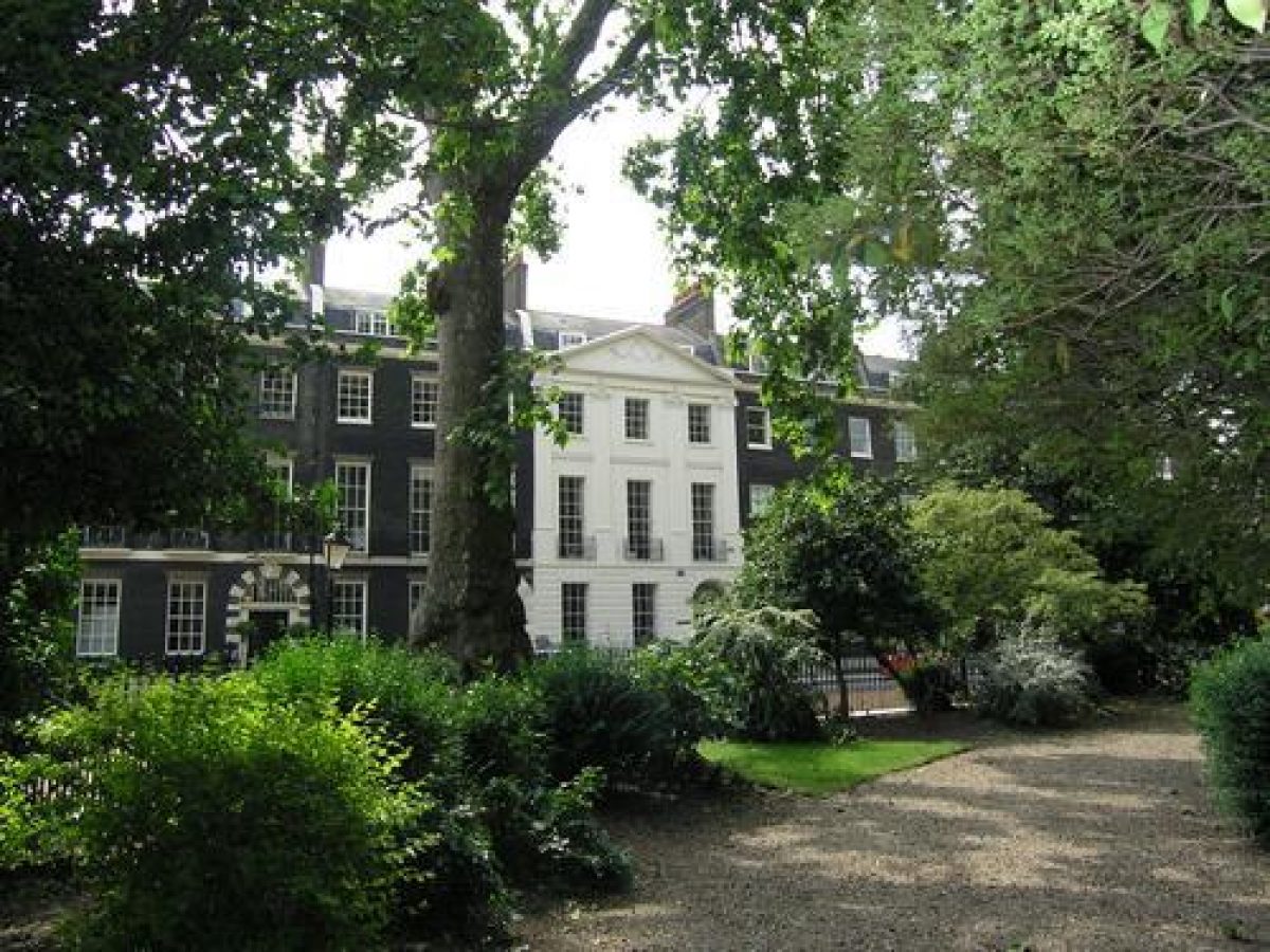
Bedford Square was built between 1776 and 1780 and was probably the work of Thomas Leverton, as well as the builder/contractors William Scott and Robert Grews. Each side of the Square was treated as a single unit. The houses were plain brick with wrought-iron balconies to the first-floor windows and the doors were decorated with Coade stone. The central house on each side was stuccoed, pedimented and had a pilastered five-bay centre. The Square was the first garden square with an imposed architectural uniformity and it set the style for garden squares in London through the late 18th and early 19th century.
The Duke of Bedford's Trustees undertook to make the garden and lay out the surrounding roadway but the work was carried out by Scott and Grews, under the direction of Robert Palmer, the chief agent of the fourth Duke. The layout in the 19th century (as seen in Hewitt's Plan of the Bloomsbury Estate, in about the 1820s, and the 1st edition Ordnance Survey map of 1870) consisted of a perimeter shrubbery and path, with serpentine paths leading from the west, north, east and south to a central feature (planting in the early 19th century and an hexagonal pavilion by 1870). In the late 19th century the design was changed to the present one, which involved moving the pavilion to the west of the garden and removing the paths that crossed the centre. These changes required little alteration to the planting.
The Bloomsbury Estate was enclosed with a system of gates, which were erected in the early to mid 19th century to guarantee the residents protection and privacy. The gates and lodges were removed between 1891 and 1893; those protecting Bedford Square in 1893.
Bedford Square residents have included: Lord Eldon, the Lord Chancellor (whose daughter eloped with G S Repton, son of Humphry Repton who designed the neighbouring Bloomsbury and Russell Squares); Thomas Leverton, the architect of the square; the second Duke of Devonshire; William Butterfield, architect; and H H Asquith, Prime Minister.
Most of the houses in the Square are now offices. The houses in the Square (Nos.1-54) are all intact and are Listed Grade I.
Period
- 18th Century (1701 to 1800)
- Late 18th Century (1767 to 1800)
- Associated People
- Features & Designations
Designations
The National Heritage List for England: Register of Parks and Gardens
- Reference: GD1154
- Grade: II*
Features
- Town House (featured building)
- Description: The houses were plain brick with wrought-iron balconies to the first-floor windows and the doors were decorated with Coade stone. The central house on each side was stuccoed, pedimented and had a pilastered five-bay centre.
- Earliest Date:
- Latest Date:
- Key Information
Type
Designed Urban Space
Purpose
Ornamental
Principal Building
Parks, Gardens And Urban Spaces
Period
18th Century (1701 to 1800)
Survival
Extant
Hectares
0.7
Electoral Ward
Bloomsbury
- References
References
- {English Heritage Register of Parks and Gardens of Special Historic Interest} (Swindon: English Heritage 2008) [on CD-ROM] Historic England Register of Parks and Gardens of Special Historic Interest
- Cherry, B. and Pevsner, N. {The Buildings of England: London 4: North} (London: Penguin, 1998) pp 323-325 The Buildings of England: London 4: North