Introduction
Ashton Court is a public park. It incorporates an early-19th-century landscape park, with formal gardens from the late-19th century. The house is now used for conferences and weddings.
The following is from the Register of Parks and Gardens of Special Historic Interest. For the most up-to-date Register entry, please visit The National Heritage List for England (NHLE):
Location, Area, Boundaries, Landform and Setting
Ashton Court is an estate of c 350ha located c 5km west of the centre of Bristol. It is in the parish of Long Ashton, separated from Bristol by the River Avon. Its boundaries are delineated by the A369, Bristol to Portishead road to the east and north, by the B3129 to the north-west, the grounds of Ashton Court Country Club and Durnford Quarry to the west, and the B3128, Bristol to Clevedon road to the south. A 3m high random rubble wall, mostly topped with black slag capstones, encloses the entire park. The landform is varied: the house stands at the bottom of steep slopes overlooking the fairly level ground of Ashton Vale to the south; north of the house steeply rising ground leads to a gently inclined plateau running across the top of the park from east to west; east of the house the land undulates towards the Cumberland Basin; and to the north-east it climbs steeply to form the western bank of the Avon Gorge.
Entrances and Approaches
There are five principal historic entrances and approaches to Ashton Court, as well as a recently made entrance off the B3129 serving a car park in the north of the park. The historic entrance drives are marked by Kennel Lodge to the south-east; South Lodge, also to the south-east; Church Lodge (1886, listed grade II) to the south leading to Long Ashton village; Clerkencombe Lodge (c 1840s, listed grade II) to the south-west; and Clifton Lodge (1886, listed grade II) on Rownham Hill to the north connecting with the Bristol suburb of Clifton. Rownham Lodge, c 900m north-east of the house, is the entrance to Rownham House, a small complex of C20 apartments. Kennel Lodge Drive, now a continuation of the public highway, Kennel Lodge Road, is the shortest route from Bristol, via Ashton Road. The single-storey Kennel Lodge is now lost amidst the development of Bower Ashton College but the drive is the main public entrance today, terminating in a public car park south-east of Summerhouse Plantation. Historically this was the service entry, approaching the rear of the house and stables from the east. Ashton Park Lodge, c 700m to the south-east of the house, also on Ashton Road, marks the entrance drive from the south.
An ornate Tudor-Gothic gateway, it is now a disused entrance to the grounds of Ashton Park School. The south drive, now mostly lost, took a circuitous route bearing west before sweeping north in a long curve, around the site intended for a lake, to approach the house at its main, south-west-facing entrance. The Church Lodge drive provides a direct route to the church and village of Long Ashton to the south. Also in Tudor-Gothic style and standing c 650m south-south-west of Ashton Court, the Lodge forms an arch over the drive which enters the park via a deep cutting before emerging into a pastoral scene and joining the drive from South Lodge. Clerkencombe Lodge is picturesquely situated in a wooded vale on a sharp bend in the B3128, Clarken Coombe c 900m south-east of the house, and opens onto a track which links with the main approach from the north at the south-west corner of the deer park.
The north drive enters through the elaborate Clifton Lodge, in asymmetrical arched Tudor-Gothic style, with ornate walls and railings. The Lodge, which is located c 850m north of the house, was built facing Bridge Road, giving direct access to fashionable Clifton across the Suspension Bridge. The north drive is the longest in the park, heading south-west between an avenue of lime trees before turning south and south-west downwards towards the deer park, the perimeter of which it skirts before turning east again to meet the drives from Clerkencombe, Church and South Lodges and then turning north to approach the house from the south.
Principal Building
Ashton Court (C15 and later, listed grade I), a former country house, is located east of the centre of the park. The house is a complex arrangement of projecting wings of different periods arranged around the core of the medieval building in the centre. It was altered and extended c 1635 with the addition of the south-west wing and in the late C18 and early C19 with the addition of the north-east wing (library or billiard room); the whole was remodelled c 1885. The sketch designs for alterations to the house provided by Repton in 1802 were forestalled by the death of his patron, Sir John Hugh Smyth, in the same year. 'The great rebuilding executed by his nephew and heir, Hugh Smyth, was of a very different character' (Bantock 1984). In 1885, winter gardens were built within one of the courtyards of the house though these have since been demolished. The house was almost derelict when taken over by Bristol City Council in 1960; it has been partially restored, principally the roof and ground floor, the latter now in commercial use by the Council for functions and entertainments. North-east, and joined to, the house is the stable block and courtyard which have recently been converted for use as a café and visitor centre (2000).
Gardens and Pleasure Grounds
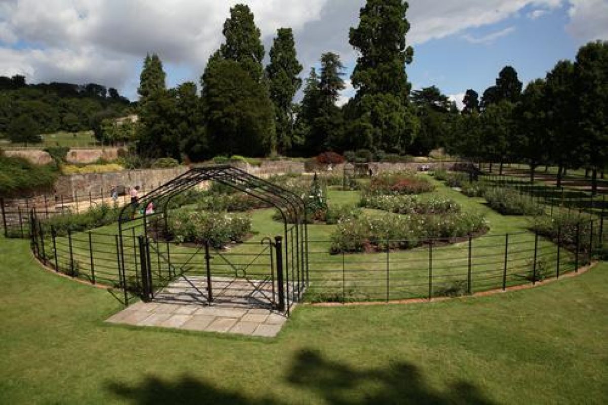
The gardens are situated south and south-east of the house. The flat, rectangular South Lawn, which is terminated by a ha-ha and contained by two stone walls, c 3m high and c 80m long to the north-east and south-west, runs up to the south-east front of the house. The garden walls (C19, listed grade II) are of rubble and brick construction elaborately topped with ashlar convex-step-concave gables. The west wall is thought to date from the C17 and is visible in an engraving by Collinson (1791). The east wall is a copy, thought to date from after the demolition of the stables in 1768 (LUC 1992). The lawn has mature cedar trees framing the view of the south-east façade of the house, a view now severely compromised by three massive Wellingtonias (c 1900) planted centre-view on the edge of the ha-ha.
A view of the south front (Rutter, 1829) shows a parterre made of a series of beds dotted across the lawn. An Edwardian photograph published in the Journal of Horticulture and Home Farmer in 1907 shows elaborate bedding out and young, modestly sized Wellingtonias and other conifers. South-west of the South Lawn is a terrace garden, formerly the wilderness, now a lawn with planting beds (late C20) and a group of massive Wellingtonias (c 1900) in the corner closest to the house. South-west lies a further terrace, with a lawn cut with rectangular beds planted with a variety of shrubs and herbaceous plants and bisected by an avenue of Pieris cultivars. There is an icehouse (?C18/C19) in a small wood south-west of this garden. Research has shown that 'the structure of walls and three main terraces can be traced back to this period' (LUC 1998). In the late C19 these gardens included an aviary and extensive ranges of glasshouses, including the Grotto, a glass-covered rock fernery designed by Messrs Pulham & Sons. The glasshouses had all been removed by 1970 (ibid).
Park
The park is extensive and its design exploits the dramatic topography of the site to afford the visitor a rich sequence of varied views. This is achieved by the placing of, and relationship between, plantations, grass, and trees. Summerhouse Plantation to the north and the woodlands west of the house define a steeply sloping curved bowl around the house. In the C17 this hillside was cut into formal terrace gardens descending towards the house but it is now down to grass with earthwork remains visible (LUC 1992). Grass rides cut between the plantations to the south, south-west, and west provide physical and visual interconnection with the landscaped areas beyond. Church Wood divides the view south-west into two set pieces: the roofs and church tower of Long Ashton village, and the borrowed landscape of Ashton Hill, surmounted by a group of Scots pine and beech trees. A feature marked as 'The Folly' appears on OS maps at the summit of Ashton Hill as late as the 1980s but no building survives today (2002).
North and west of Clerkencombe Lodge is Pill Grove, the east end of which is old wood pasture, containing c 200 veteran oak pollards; it has recently been restored as deer park (c 1996). The west end of Pill Grove is a mature plantation of beech. Winding walks through Pill Grove provide views eastwards over the deer park and south to Clerkencombe Lodge, before emerging northwards at the top of the slope onto the plateau. Durnford Quarry at the west end of the plateau has recently been extended eastwards (1990s) and will eventually remove most of the adjacent Top Park Field. There are further plantations, containing some noteworthy Wellingtonias and oak pollards, on the lip of the plateau as far as Keeper's Cottage with its walled garden (c 1720) to the east, contrasting with the predominantly open aspect to the north. On the plateau is an 18-hole pitch and putt public golf course and, near the north boundary, a miniature railway.
The area southeast of the Clifton Drive, Lambing Pen Field, shows evidence of ancient field systems, as do the rough grazing fields running down to Clanage Road to the east. The area between Rownham and Summerhouse Plantations has recently been converted to deer park. The whole of the parkland is planted with a wide range of trees including some very notable veteran oak and sweet chestnut pollards. The entire park is about to undergo (early C21) a comprehensive programme of restoration, funded by the Heritage Lottery Fund and Bristol City Council.
Kitchen Garden
The kitchen gardens to the house were located in Bower Ashton, in the area 400m east of the house around Park Farm, and 500m east of the house on the north side of Kennel Lodge Road. Some of this land has been built over for Bower Ashton Art College and some is now (2002) used for allotment gardens.
Maps
- Ashton Court Estate 1765, surveyed 1740 (drawn copy at 1:10,000), (Bristol Record Office)
- Map of Long Ashton, late C18 (extract copy on EH file)
- Ashton Court, map showing roads to be stopped up and site of proposed lake, early C19 (extract copy on EH file)
- Estate map, Sir John Smyth in Hand, 1826 (copy on EH file)
- Tithe map for Long Ashton parish, 1826 (copy on EH file)
- Estate plan, 1865 (copy on EH file)
- Edward Gabriel, Plan of alterations to the Terrace Gardens, 1904 (Bristol Record Office)
- Reconstruction of Seventeenth Century Layout, (in LUC 1992)
- Ashton Court Landscape Restoration and Development Plan, (Bristol City Council 2000)
- OS 6" to 1 mile:
- 2nd edition published 1905
- 1930 edition
- 1938 edition
- OS 25" to 1 mile: 1st edition published 1885
- Illustrations [all reproduced in LUC 1992]
- View before demolition of stables, C18
- Collinson, View of south front of Ashton Court, 1791
- Rutter, View of south front and lawn, 1829
Description written: September 2002
Register Inspector: SH
Edited: January 2003
- Visitor Access, Directions & Contacts
Telephone
0117 963 3438Access contact details
The house is now used for conferences and weddings. The gardens and estate are open from 8am throughout the year. Admission is free.
Directions
The gardens are 2 miles west of Bristol, on the Portishead Road.
- History
The following is from the Register of Parks and Gardens of Special Historic Interest. For the most up-to-date Register entry, please visit the The National Heritage List for England (NHLE):
An 18th- and 19th-century landscape park on an earlier deer park, laid out after designs by Humphry Repton (about 1802), with formal gardens (late 19th century) around a former country house. Since 1960 the site has been used as a public park.
Historic Development
Evidence of human occupation from the Bronze Age, Iron Age and the Roman period, as well as medieval strip fields, ridge and furrow, and lynchets, has been found within the western end of the park at Ashton Court. These remains of ancient field systems are among the best preserved in the region and owe their survival to the enclosure of the land as a deer park in the 14th century. In 1312 'two hundred and fifty acres of land were under single ownership' and in 1545 the estate was bought by John Smyth, former sheriff and mayor of Bristol (LUC 1992).
Ashton Court remained the property of the Smyth family until 1959, when it was bought by Bristol City Council. The land surrounding the 15th-century house formed an extensive deer park and there is field evidence of 16th- and 17th-century formal gardens rising in terraces up the steep slope north-west of the house (LUC 1998). An estate map of 1765, surveyed in 1740, shows that the park was smaller than today and criss-crossed with tracks and two avenues of trees (Bantock 1984).
Humphry Repton (1752-1818) visited the estate in 1802 and advised on changes to the landscape and, although no Red Book was made, Repton wrote to the owner Sir John Hugh Smyth in October 1802, 'I hope the ground I marked out for plantations has been prepared so as to be planted this season' (quoted in Harding and Lambert 1994). In 1803-4, 10,000 trees were purchased from Miller and Sweet's nursery and the extensive planting from this period, along with the sweeping drives south of the house, survive. Repton complained however that his designs had been 'adopted only in the general outline, and placed very different to what I intended' (Repton 1803).
An undated plan of about 1800 shows proposals for stopping up the roads south of the house. Lightly sketched in pencil in an unknown hand is a new approach from the south-east which curved around a lake to be constructed between the house and the Ashton Road boundary (LUC 1992). Although the drive and entrance lodge were built, the lake was not. The basic landscape structure from the Repton period survives intact, with significant additions in the 19th century, particularly an entrance drive from Rownham Hill in the north, built to take advantage of the opening of the Clifton Suspension Bridge. The 19th century also saw the addition of exotic trees, especially conifers, in the park and new gardens close to the house.
Bristol City Council had adopted proposals to buy the Ashton Court estate for public use in the 1930s but the intervention of the Second World War and post-war austerity meant that the purchase was not completed until 1959, by which time the house was in an advanced state of dereliction. The park has been little altered by the City Council and it continues (2002) to operate as a deer park and public park.
- Associated People
- Features & Designations
Designations
Conservation Area
- Reference: Long Ashton(for southern part of park)
The National Heritage List for England: Register of Parks and Gardens
- Reference: GD1547
- Grade: II*
The National Heritage List for England: Listed Building
- Reference: Ashton Court
- Grade: I
Features
- Stable Block
- Key Information
Type
Park
Purpose
Recreational/sport
Principal Building
Parks, Gardens And Urban Spaces
Survival
Extant
Hectares
358
Open to the public
Yes
Civil Parish
Long Ashton
- References
References
- Harding, S and Lambert, D {Parks and Gardens of Avon} (1994) pp7, 65, 81-82 Parks and Gardens of Avon
- Repton, H., (1803) Observations on the theory and practice of Landscape Gardening; including some remarks on Grecian and Gothic Architecture
- Carter, G et al {Humphry Repton Landscape Gardener 1752 - 1818} (1982) p 161 Humphry Repton landscape gardener 1752-1818
- Daniels, S {Humphry Repton: landscape gardening and the geography of England} (1999) pp 238-239 Humphry Repton : landscape gardening and the geography of Georgian England
- {English Heritage Register of Parks and Gardnes of Special Historic Interest} (Swindon: English Heritage 2008) [on CD-ROM] Historic England Register of Parks and Gardens of Special Historic Interest
- Pleydell Smithyman{Ashton Court Estate Management Plan} (2009) Ashton Court Estate Management Plan
- (1907) Horticulture & Home Farmer
- Bantock, A., (1984), pp 123-37 The Later Smyths of Ashton Court from their letters 1741-1802
- (Land Use Consultants 1992) Ashton Court Park - Study of the development of the designed landscape
- 11 (1992), pp 15-18 Avon Gardens Trust Newsletter,
Contributors
Avon Gardens Trust
- Related Documents
-
CLS 1/322/1
Restoration Management Plan - Digital copy
Land Use Consultants - 1998
-
CLS 1/322/1