Introduction
A park, woodland and agricultural estate of about 1400 hectares, originating in the Medieval period with later design by Lancelot Brown. There is a central landscape park of 36 hectares, including 19th-century ornamental gardens occupying about 6 hectares to the south of the house.
Terrain
The house and gardens lie on a plateau surrounded by the woodland and park, which overlie shallow valleys.The following is from the Register of Parks and Gardens of Special Historic Interest. For the most up-to-date Register entry, please visit The National Heritage List for England (NHLE):
An early C19 country house with gardens, laid out largely 1810s-1830s to suggestions made by Humphry Repton (Red Book 1813) towards the end of his career, surrounded by an extensive park and woodland. Lancelot Brown worked on the park from 1759 to 1768.
Location, Area, Boundaries, Landform and Setting
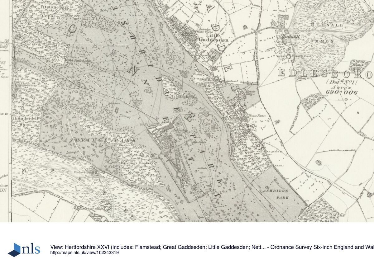
Ashridge House lies c 5km north of Berkhamstead, on the western boundary of Hertfordshire with Buckinghamshire. The c 200ha site is bounded to the west by the Ringshall to Berkhamstead lane, to the north-east by the village of Little Gaddesden, and to the south by Berkhamstead Common. The estate lies in the northern half of the Chiltern Hills, close to the south-west-facing scarp. The house and gardens lie on a plateau surrounded by the woodland and park, which overlie shallow valleys. The setting is rural and largely wooded, with the villages of Ringshall, Little Gaddesden and Nettleden extending along the north-east boundary.
Entrances and Approaches
The main drive enters off Little Gaddesden main street 1.2km north of the house, past a row of C19 estate houses and a brick C19 lodge. The drive descends south through woodland, crossing the open bottom of the Golden Valley 600m north of the house. From here the drive ascends the wooded southern valley side into open parkland north of the house, arriving obliquely at the main entrance on the north front of the house. Formerly (OS) the north drive entered at Deer Leap Lodge (early C19, probably James Wyatt 1808(13, listed grade II), standing 2.5km north-west of the house, a two-storey stone tower lodge in Gothick style. From here the drive formerly ran south, now partly covered by C20 development for 100m at its northern end, its course extant to the south of this development, joining the main drive at the Little Gaddesden Lodge.
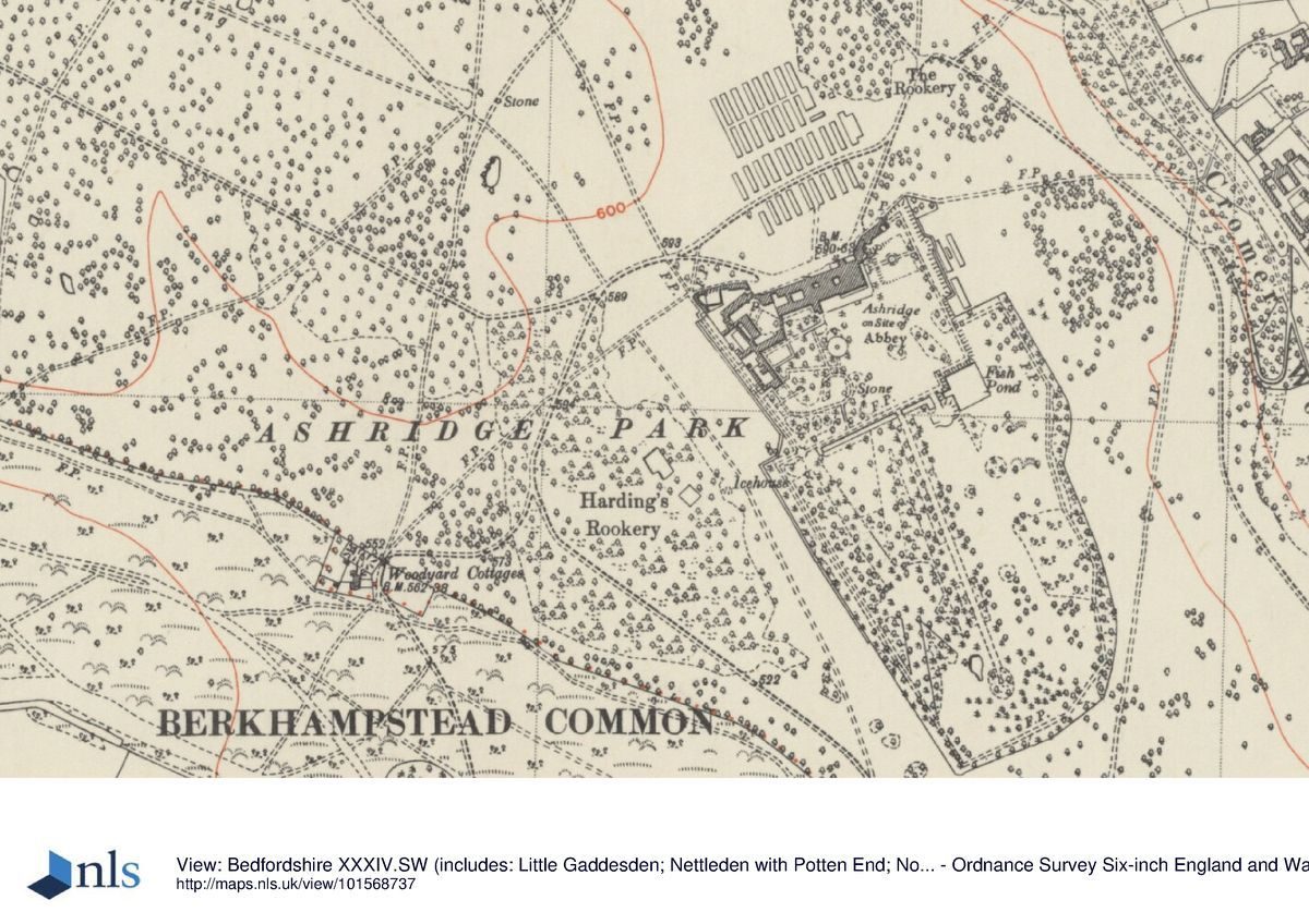
The south-west drive enters the park 800m south of the house, continuing north-west off the lane from Frithsden, passing the Berkhamstead Lodge (early C19, possibly Jeffry Wyatt, listed grade II), a single-storey, half-timbered lodge. From here the drive curves up the hillside through Harding's Rookery, approaching the main entrance on the north front of the house obliquely from the west through open parkland.
A former drive, now partly under cultivation, entered c 4km south-east of the house, off the Frithsden to Nettleden lane. The drive extended north-west, passing some 500m from the entrance to the park over a track, formerly the main north/south route linking the two villages. The track is sunk into a deep cutting supported by extensive retaining walls riveted with brick and flintwork, the drive being carried over it by a brick and flintwork bridge (the whole c 1808, listed grade II) with a single Tudor arch and stone dressings. The remains of the drive ascend north-west through the park along a valley bottom which c 500m south-east of the house becomes the Golden Valley, continuing north to join the main north drive 300m north-east of the house. The half-timbered Nettleden Lodge (late C17, remodelled early C19 by Jeffry Wyatville, listed grade II) stands on the drive, c 1.8km south-east of the house, formerly the principal gate lodge to Ashridge.
Principal Building
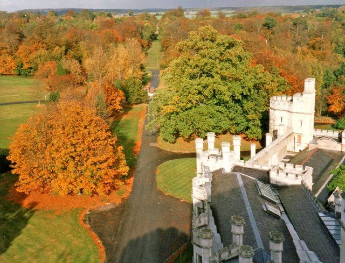
Ashridge House (James Wyatt 1808-13, completed by Jeffry Wyatt (Sir Jeffry Wyatville after 1824) 1815-17, listed grade I) stands towards the northern end of the site, set on a broad plateau which falls away to the west, south and east. The large rectangular stone house is built of local Totternhoe stone, being a fine example of an early Gothic Revival mansion. Wings extend to north-east and west, screening the garden and service/office yards respectively from the main approaches. Two stable courtyards stand to the west of the service yards. The house incorporates the remains of the medieval College of Bonhommes, including a c 70m deep C13 well.
Gardens and Pleasure Grounds
The garden and Arboretum extend for 700m south of the house on the south side of the plateau on which it stands, the ground falling sharply to the south, and to the east into the Golden Valley, with views across the valley. To the west the ground descends gently into Harding's Rookery woodland. The area is divided into northern and southern halves, that to the north being laid to lawn with formal and informal garden features, and that to the south being an informal arboretum.
The garden door is set into the centre of the south front of the house, opening onto a broad terrace with a gravel path running along the south front. Adjacent to the south of the path lies a formal parterre, with clipped yew hedges surrounding beds enclosed by low clipped box hedges and planted with seasonal bedding. The west end of the terrace is overlooked by the former conservatory, altered in 1928 by Clough Williams-Ellis to form the college dining room. Stone steps opposite the garden door lead down to informal lawns beyond.
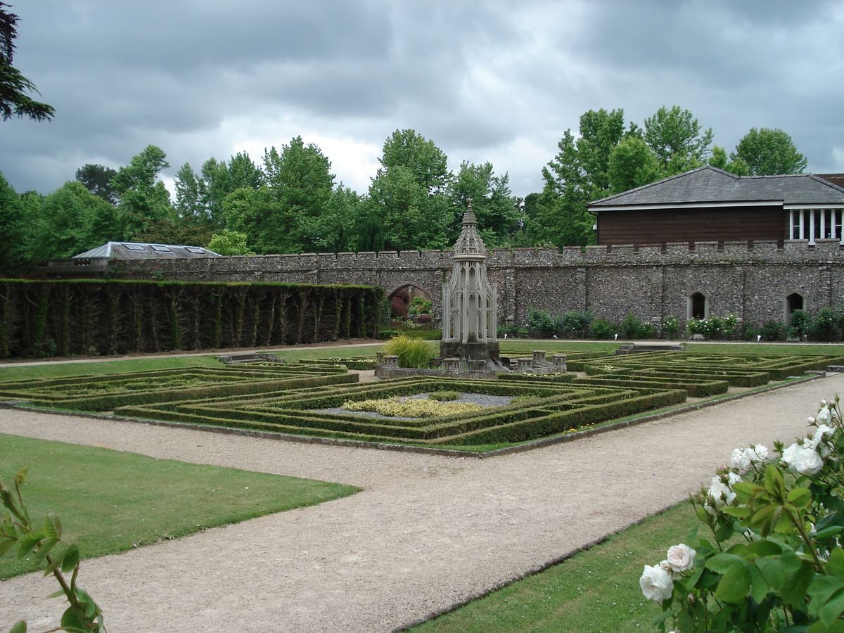
The terrace path extends to the south-east corner of the house where further stone steps set into the corner lead down to the lawns beyond, the terrace turning north to run along the east front as the east terrace. The east terrace, also reached from the former library, is bounded by a broad flight of stone steps leading east into the sunken Italian Garden, dominated by a central stone pond surrounded by a ring of specimen yews set into a gravel path. Surrounding formal lawns contain geometric flower beds. To the north the Italian Garden is overlooked by Jeffry Wyatt's elaborate stone orangery, now converted to offices. This area is screened from the lawn adjacent to the south front by mature trees, largely yews.
A path extending east from the Italian Garden joins a perimeter garden path leading south across lawns, with views east over a grassed ditch and bastion towards the Golden Valley. The path reaches the south-east corner of the garden, 200m south-east of the house, here overlooking to the south a square, sunken former skating pond lying beyond, bounded by flint retaining walls topped by a clipped yew hedge. The area is laid to lawn with a gravel perimeter path. Above the southern corner of the pond stands a square, clipped beech 'house'. The perimeter path continues west along the south boundary of the garden overlooking lawns to the north, framing the south front, and to the south overlooking the Arboretum, particularly the Rhododendron Walk and flanking Wellingtonia Avenue.
The perimeter path gives access to the more intensively cultivated western half of the garden. From the western arm of the perimeter path a further path leads east into the Fernery Garden lying 100m south-west of the house. This enclosed area is overlooked to the north by a brick fernery (Sir Matthew Digby Wyatt 1864) standing on a grass terrace flanked by two flights of stone steps leading down to a small lawn. The interior north wall of the fernery is largely covered with rough Totternhoe stone with ferns planted in the crevices. At the centre of the lawn lies a circular flower bed flanked by four specimen standard trees.
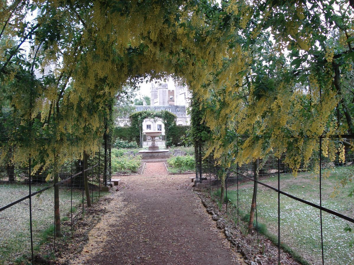
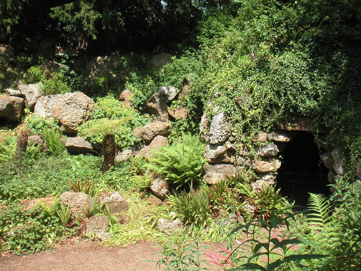
A path leads from the south-east corner of the Fernery Garden to the Grotto Garden (Digby Wyatt 1851, listed grade II), set into an earth mound planted with mature trees. The sides of the Grotto Garden, in the form of an amphitheatre, are lined with local puddingstone. Formerly a pond lay on the north side, fed by a cascade from the mound to the east, this now largely filled in. The east side of the Grotto is formed by a puddingstone wall into which are let three openings. Two to the north give access to a domed chamber containing the grave of a favourite horse (d 1857), that to the south being the entrance to the Souterrein, a flint-lined tunnel leading through the mound to the Duchess' Private Garden, an open undulating area of lawn lying adjacent to the west side of the main lawn, set with informal island beds and enclosed by shrub planting. A path from this area leads north to The Rosery, a circular rose garden set in lawn, enclosed by a clipped yew hedge. Within lie formal rose beds separated by gravel paths, encircling a stone basin and fountain.
A lawn set with mature specimen trees, including several large cedars, extends west from The Rosery to the Monks' Garden, a rectangular, formal sunken parterre surrounded by gravel paths. Stone steps at the centre of each side lead down into the parterre, divided into four quarters enclosed by clipped dwarf box hedges and planted at the centre of each with further box plants clipped into heraldic devices. At the centre stands the Holie Well (Jeffry Wyatt 1820, listed grade II), a tall, cast-iron, crested and buttressed gothick conduit head surrounded by an octagonal moat. The Monks' Garden is separated from the informal lawns to the south by a clipped yew hedge, and overlooked to the north by the Monks' Barn (late C14, listed grade I with the house), a timber-framed barn, extended and remodelled by Jeffry Wyatt (1816) when it was converted into a covered walk facing the Monks' Garden. From the Monks' Garden a path leads east back to the west end of the terrace on the south front.
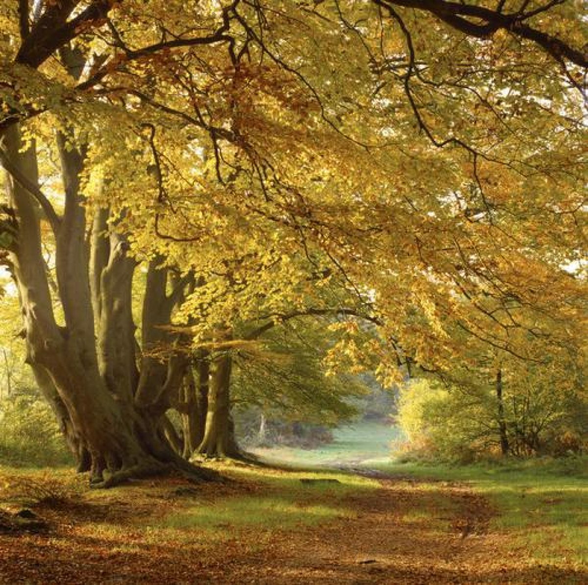
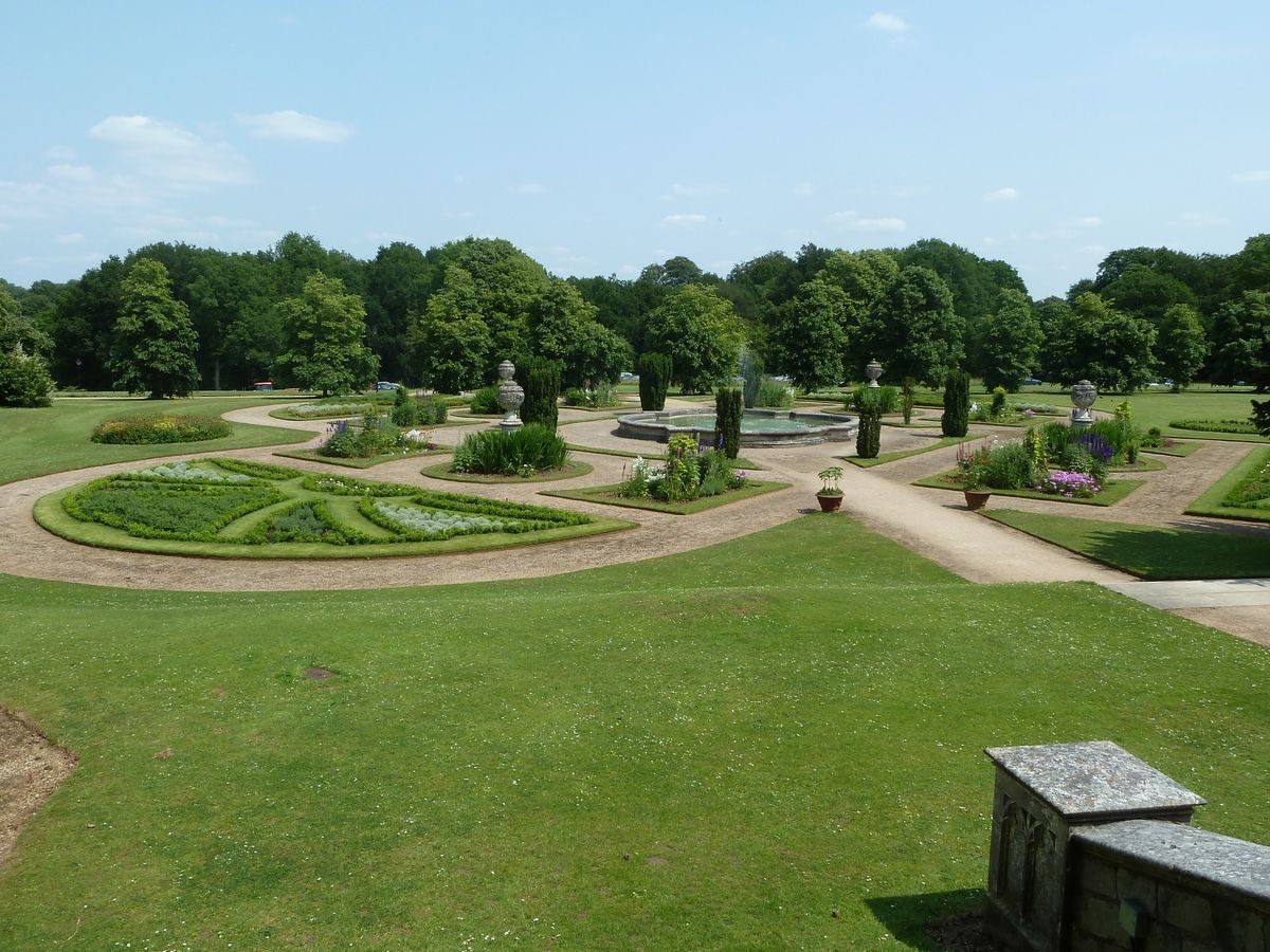
The c 16ha Arboretum (laid out in the second half of the C19), to the south of the garden, is laid to rough grass and planted with many fine specimen trees, set in clumps, singles and avenues. It is dominated by the 1858 Wellingtonia Avenue, underplanted by the Rhododendron Walk which leads c 400m south to the Prospect Mound, an earth mound planted with mature trees, possibly dating from the C17 (when it would have been part of the deer park, NT 1989). To the south of the Mound lie many mature cedars, with to the north-west Repton's Arbour (1998), a thatched rustic seat based on Repton's drawing of a rustic seat in the 1813 Red Book.
By the early 1760s (Grey, 1762), compartmentalised gardens and orchards surrounded the site of the first house, built around the monastic remains. The south-west and north-east boundaries of the settlement were each marked by single lines of trees which extended parallel south-east across the park, along the boundaries of what was to become the Arboretum in the C19. The Prospect Mound was present, aligned on the south front of the first house and planted with trees around the base. The area of the present garden and Arboretum was largely open, except for a few scattered trees. Later in the 1760s Henry Holland built the second house to the north-east, where now is sited the orangery. Of the gardens associated with these two houses only the parallel lines of trees, replanted, remain.
In 1813 the seventh Earl of Bridgewater employed Humphry Repton to produce suggestions for the garden around the new house which was being built by James Wyatt on the site of the first house and monastic ruins, adjacent to Holland's house. Repton's Red Book proposed laying out the gardens to the south and east of the new house (as was carried out), leaving the eastern half as informal open lawns with scattered trees and shrub beds, overlooked by the Holland house (replaced by the present orangery) and the south front embellished by an embroidered parterre and paved terrace. The area south of the Holland house Repton referred to as the original lawn and pleasure ground, with that south of the new south front referred to as an addition in the same style. Repton recognised that the area south of the house could not be planted without injuring the views from the house to the park, and that this area should be thrown into the park (Red Book 1813). Similarly he noted on a plan within the Red Book views to the 'Wood' and 'Valley' from the eastern half of the garden, indicating the Golden Valley to the east as the subject of views, together with the eastern hillside beyond.
Repton proposed that the western half of the garden should be more elaborate, laid out with a number of intimate formal garden features surrounded and enclosed by shrubberies and linked by serpentine paths. The compartments he suggested included the Monks' Garden, the Magnolia and American Garden, the Broad Sanctuary and Holy Well, an Arboretum of Exotic Trees (an open lawn planted with clumps of trees, enclosed by the formal features) and a Rosarium and Fountain. In total there were fifteen different styles of garden compartments. Some of Repton's suggestions were taken up by Jeffry Wyatt, although several were modified. Other suggestions were introduced later on in the century, particularly by Lady Marian Alford during the mid C19, who also introduced the Italian Garden, designed in the 1850s by Lady Logan, her aunt.
Park
The park surrounds the house and pleasure grounds, the northern end comprising open parkland (since the 1920s largely covered by a golf course laid out by Colt) enclosed by woodland. The area north of the house is largely laid to an expanse of open lawn, the view from the main door being partly obscured by a car park lying 50m to the north and screened by late C20 planting. The Prince's Riding extends through woodland to the north-west, aligned at its eastern end upon the main entrance on the north front. The ride begins 350m from the house, extending for 2.2km north-west, crossing the Aldbury to Little Gaddesden lane 1.6km from the house, where the park boundary is marked by the Deer Leap, a ditch with a retaining wall against the east side, the ride terminating at the Bridgewater Monument (Sir J Wyatville 1831-2, listed grade II*).
Within the north park stands Old Park Lodge (C17, listed grade II), formerly the verderer's lodge and lookout, lying at the convergence of several former rides through the park. A C20 golf clubhouse stands c 250m north of Old Park Lodge, at the heart of the golf course within the northern park. Several areas of C20 development stand within the park and on its boundaries. The park lying to the north and east of the house and garden/Arboretum is dominated by Golden Valley, a natural valley possibly embellished by Lancelot Brown during his period of employment by the third Duke of Bridgewater from 1759 to 1768 (the extent of Brown's work is presently (1998) unknown, although his work is recorded in his accounts for the period). The smooth valley bottom and lower slopes are largely laid to pasture, with the northern end being overlaid by a golf course, the upper valley sides being planted with woodland.
The southern half of the park is dominated by the southern extension of the Golden Valley, continuing south-east below the Arboretum and house, flanked by steep hillsides. This Valley is largely laid to pasture and arable. Formerly (OS 1883/4, 1901, 1922) this section of the park was extensively planted with parkland trees. Again, some of the park boundaries have been lost to C20 development.
By the 1760s (Grey, 1762) the park had been laid out around the house, with singles, clumps and copses of trees, taking in the c 400ha C16 and C17 deer park. It was at this time that Lancelot Brown was working on the estate. To the north-west the park was largely woodland, with Park Lodge at the centre, overlooking several formal rides through the trees, including Prince's Riding extending prominently from the park around the house to the Ringshall lane boundary. Informal open lawns, planted with scattered trees, were cut into the woodland. At that time the south park only extended south approximately as far as where Golden Valley Farm now (1998) stands. The south park was extended during the C19, as formal enclosure allowed further addition to the south.
Kitchen Garden
The now disused (1998), brick-walled kitchen garden (C18, listed grade II), divided into several compartments by further walls, lies c 2km south-east of the house and is known as Frithsden Gardens. It stands adjacent to the north side of the Ashridge to Frithsden lane and is largely laid to pasture. The area is clearly shown laid out as kitchen gardens in the 1760s (Grey, 1762).
Maps
- Grey, Estate plan of Ashridge, 1762 [reproduced in Wainwright 1989]
- Dury and Andrews, A topographical Map of Hartford-shire, 1766
- OS 6" to 1 mile:
- 1st edition published 1883/4
- 2nd edition published 1901
- 3rd edition published 1922
Archival items
- H Repton, Red Book for Ashridge, 1813 (private collection)
Description written: December 1998
Amended: August 2000
Register Inspector: SR
Edited: November 2000, March 2023
- Visitor Access, Directions & Contacts
Telephone
441442851227Access contact details
The estate is open all day, all year. Visitor Centre open March - November, 12 noon to 5.00pm.
Directions
Off the B4506 between Berkhamstead and Northchurch.
Owners
The National Trust
- History
The following is from the Register of Parks and Gardens of Special Historic Interest. For the most up-to-date Register entry, please visit The National Heritage List for England (NHLE):
13th - 16th Century
A medieval monastic college, founded in 1283 at Ashridge, and owning a c 50ha deer park, was dissolved in 1539, becoming a royal residence for Henry VIII's children and passing to the Princess Elizabeth after her father's death.
17th Century
Thomas Egerton, Queen Elizabeth's Lord Chancellor, bought the estate in 1604, incorporating the former monastic buildings within his own domestic buildings. His son John purchased an earldom following his father's death in 1617 and assumed the title Bridgewater.
18th Century
The fourth Earl (d 1745) became the first Duke of Bridgewater, and his younger son, Francis, the third Duke (d 1803), also known as the Canal Duke, consolidated the family fortunes by developing canals during the late C18. He employed Henry Holland (1745-1806) in the 1760s to build a new house on the site of the present orangery, employing Lancelot Brown (1716-83) from 1759 to 1768 to improve the parkland.
19th Century
John Egerton, the seventh Earl, employed James Wyatt (1747-1813) from 1808 to build a new house on the site of the adjacent monastic buildings, the Holland house being subsequently demolished, together with most of the associated garden features.
In 1813,Humphry Repton (1752-1818) produced a Red Book of suggestions for the gardens and pleasure grounds immediately around the house, his designs being laid out piecemeal over the following decades.
The second Earl Brownlow inherited the estate in 1851, aged eleven, the estate, including the garden, being administered and improved by his mother, Lady Marian Alford.
20th Century
The estate was sold up in the 1920s, the house and garden becoming a training centre for Conservative Party workers, the park and woodland being largely acquired by the National Trust and peripheral plots being sold for housing.
The house became the Ashridge Management College in 1959, in which use it and the gardens remain.
Period
18th Century (1701 to 1800)
- Associated People
- Features & Designations
Designations
The National Heritage List for England: Register of Parks and Gardens
- Reference: GD1274
- Grade: II*
Features
- House (featured building)
- Earliest Date:
- Latest Date:
- Avenue
- Parkland
- Woodland
- w
- Key Information
Type
Estate
Purpose
Ornamental
Period
18th Century (1701 to 1800)
Survival
Extant
Hectares
200
Open to the public
Yes
Civil Parish
Little Gaddesden
- References
References
- {English Heritage Register of Parks and Gardens of Special Historic Interest}, (Swindon: English Heritage, 2008) [on CD-ROM] Historic England Register of Parks and Gardens of Special Historic Interest
- Stroud, D., {Capability Brown} (London: Faber, 1975), pp. 160, 165 Capability Brown
- Stroud, D., {Humphry Repton} (London: Country Life, 1962), pp. 101, 215 Humphry Repton
- Rutherford, Sarah {Ashridge Park Conservation Plan} (2009) Ashridge Park Conservation Plan
- Rutherford, Sarah {Ashridge Garden Landscape Conservation Plan (not NT)} (2009) Ashridge Garden Landscape Conservation Plan (not NT)
- Thompson, M., (Architectural Association Diploma dissertation 1996) The Gardens at Ashridge, a study of the gardens and plan for their conservation
- Wainwright, A., (draft report for National Trust, 1989) Ashridge Park Survey
- (5 November 1898), pp 560-3; (12 November 1898), pp 592-6; 50 (6 August 1921), pp 160-6; (13 August 1921), pp 192-8; 58 (7 November 1925), pp 687-9 Country Life, 4