Introduction
Beechwood is a 17th-century landscape park, redesigned in 1753 by Lancelot Brown. A formal garden was added in the mid-19th century. The park was reduced in size in the 20th century, with much of it being returned to arable. Only the grounds and gardens surrounding the house (now a school) survive.
Statement of Significance
Beechwood Park is an 18th-century site containing the remnants of some of Capability Brown's earliest work. It also had visual links, designed by Brown, to neighbouring hill-top properties, Cheverells and Hill Farm (an eyecatcher with a ‘gothic' façade). It has previously been recommended for inclusion on the English Heritage Register of Parks and Gardens (Phibbs & Owen, Debois Landscape Survey Group, 2000).
Description
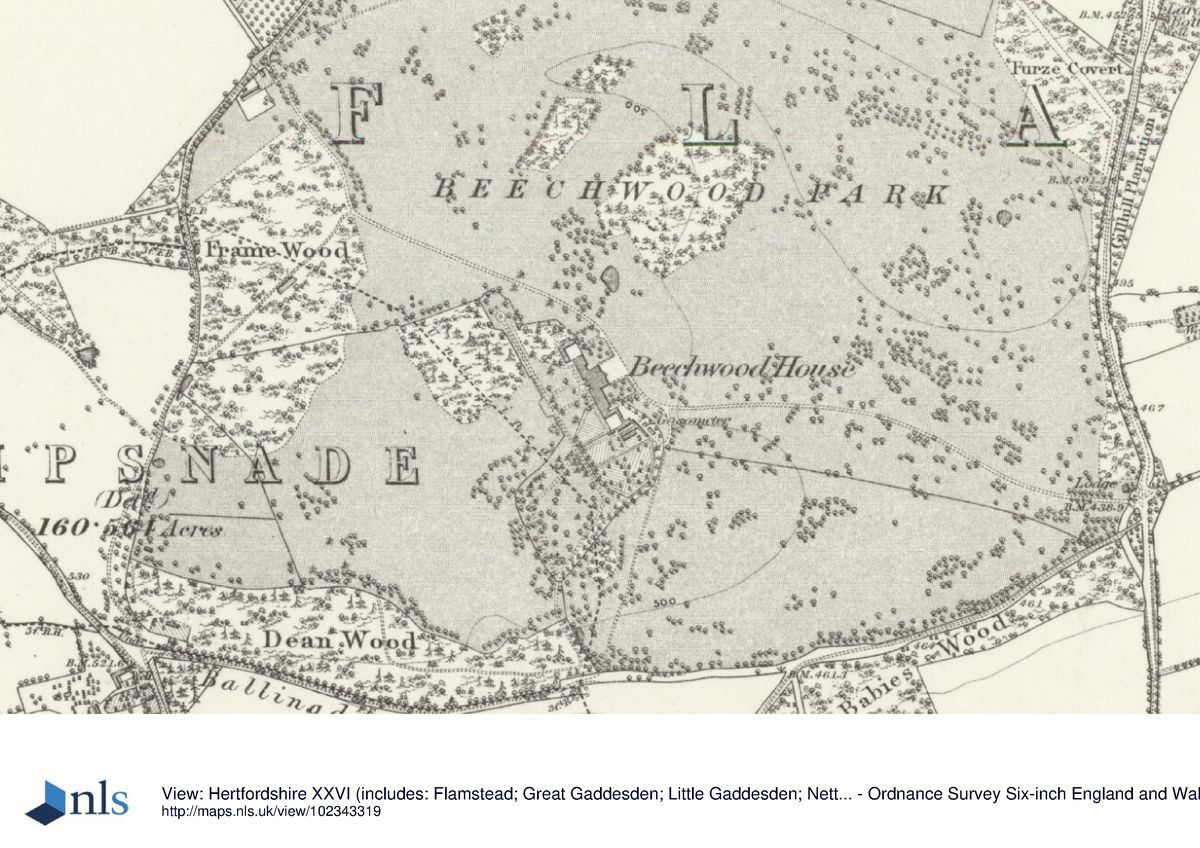
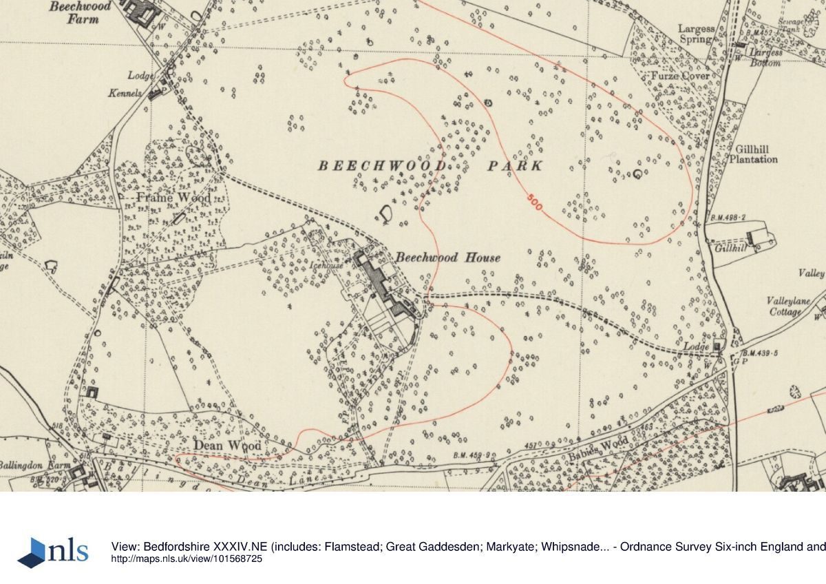
This is a country house and estate, now a school. It is situated on the 155m contour overlooking a dry valley running roughly east to west with rising ground to Cheverells, the Dower House, to the north on the 160m contour and Hill Farm to the south on the 155m contour.
Areas of woodland garden which are vestiges of the late-17th or early-18th century layout flank the vista but much of the southern lawn is now playing fields and the northern park is arable. New school buildings cluster round the house, although the vista southwest, farmed by woodland, has been preserved.
The main drive curves gently westwards from the main gates, possibly designed by Sir William Chambers, on Pickford Lane through parkland to the north west of the house. The 19th-century Peacock Lodge lies to the north of the drive.
Additional Sources of Information
Debois Landscape Survey Group, Beechwood Park Conservation Management Plan (awaiting details)
Debois Landscape Survey Group, Cheverells: an appraisal of the historic landscape (2000)
Curtis, L. Forgotten Pilots: Story of the Air Transport Auxiliary, 1939-45 (1971, Foulis)
Hertfordshire Gardens Trust, Williamson T., The Parks and Gardens of West Hertfordshire (HGT, 2000) pp29-30, 40-42
Leiper, H. ‘Mr Lancelot Brown and his Hertfordshire Clients' In: Hertfordshire Garden History Volume II: Gardens pleasant, groves delicious (Spring, D. ed) (University of Hertfordshire Press, 2012) pp92-120
Prince, H., Parks in Hertfordshire since 1500 (2008, University of Hertfordshire Press)
Stroud, D., Capability Brown (1975) pp 70-71, 217
Turner, R., Capability Brown and the Eighteenth-century Landscape (Phillimore,1999) pp109, 173
Young, A. General View of the Agriculture of Hertfordshire (London, 1804) p.147
Beechwood Park Country Life, Vol 84 12 November 1938 pp 474,498
Hertfordshire Gardens Trust Dacorum Local List: Beechwood Park
Hertfordshire Gardens Trust Dacorum Local List: Cheverells
Beechwood House School Archives:
Survey of Beechwood Park, L Brown, 1753 (copy)
Design for Beechwood Park, L Brown, 1754 (copy)
Estate Maps n.d.
Hertfordshire Archives and Local Studies (HALS):
DEMy/1/1/1/8/7 Sales Particulars for outlying part of Beechwood Estate, Brown & Merry 1935
DE/X269/B20 Sales Particulars for 700a, portions of Beechwood estate, 4 farms, cottages, The Chequers PH Plan. Bidwell & Sons 1935
DE/X269/B36 Sales Particulars for Beechwood Estate, 1679a: park, 4 farms, 4 cottages. Plan. Bidwell & Sons 1964
Maps:
Dury and Andrews, A Topographical Map of Hartford-shire, 1766
A Bryant, The County of Hertford, 1822
DSA4/38/2 Flamstead Tithe Award Map 1838
Illustrations:
D/E/BG4/1/2/7 and /8 and /9 Drawings by J C Buckler Vol IV, Pt II Beechwood Park, the seat of Sir John Seabright [sic] 1839
RCHM 9BB93/9022 Brown Drawings for gothic folly and ice house
- Visitor Access, Directions & Contacts
Directions
West of the A1 junction 9
- History
The site was previously the lands of the Priory of St. Giles in the Wood (Benedictine Nuns) founded around 1120 and suppressed 1537 (the buildings of which stood some 100m to the east of of the present house). In 1538 the manor was given to Sir Richard Page by Henry VIII. The first house was probably built for Page (d.1598) and extended and remodelled over the years. Thomas Saunders bought it in 1628. In around 1702, Sir Edward Sebright had extended the 17th-century house but there is no evidence of changes to the landscape at this time. The grounds, in a ‘late-geometric style' are shown on the Brown survey of 1753 with extensive woodland cut through with rides, regular blocks of woodland and a double avenue leading to a rond-point, possibly laid out in the 1702s and 30s, the whole amounting to 190 acres, with gardens of 6 acres.
In 1754 Lancelot Brown was commissioned by Sir John Sebright to supply designs for the property. Here the thick woods were thinned, rather than extensive extra planting, as confirmed by his plan of 1754 (preceded by the 1753 survey). The small rectangular, bastioned formal gardens were to be removed and a tree-studded lawn laid out to the south surrounded by a belt of existing trees. The formal wilderness paths and blocks of woodland were to be removed or softened, woodland to the north to be thinned to give open areas of wood-pasture and dense clumps formed from existing trees. Serpentine edges were to be given to woodlands although the avenue and rond-point were not affected. The plan includes a ‘barn with ornamental front' on the eastern fringes of the park at a kilometre's distance, where the perimeter belt was replaced with a ha-ha. Other plans for house alterations, an ice-house and a small bath-house in the gothic style are attributed to him. An ice-house exists but there is no evidence for the bath-house having been built.
Further to the south-east a farmhouse, Hill Farm on the crest of the hill was built as an eyecatcher by Sir Thomas Sebright with a Gothic façade, and the dower house, Cheverells, on the hill to the north was also given a Brownian landscape. (Debois, 2000). Cheverells had two main phase of landscape development, 18th century which utilised the sweeping views from the top of the hill and the visual connections to Beechwood and its parkland, and the early-20th century which largely turned the views away from Beechwood.
The 1766 Dury and Andrews map shows the old path pattern still extant in the Beechwood southern wilderness and the earlier bastioned ha-ha had not been removed by that date. Undated estate maps and the 1st edition Ordnance Survey map suggest that some Brownian clumps were planted along the northern boundary. In the second half of the 18th century, Sebright paid the nurseryman, John Davenport several amounts,varying from £12 to £38 over the period 1772 - 84, although it is not known what was purchased. In 1804 Arthur Young comments that he had:
'Rarely seen finer trees than at . . . Beechwood: it has the name in strict propriety, for the number of stately beeches is great; but the soil agrees with all sorts of trees; the cedars are immense; the oaks very large; the ash straight and beautiful; the larch, spruce and Scots fir equally fine, but the beech uncommon.'
In the 19th century formality came in the form of a Rosarium of 1857 with a circular arrangement of dwarf, miniature climbing and standard roses enclosed by Aucuba hedges with yews at each of the four corners. The terraced gardens beneath the west front of the house were probably introduced in the 1860s but there is no evidence for the planting of the rosarium, although a 19th-century photograph does show formal parterres surrounded by a pierced balustrade with clipped shrubs. In 1924 a census by the Forestry Commission recorded that one of the few remaining plantations of pure beech was situated at Beechwood Park.
Much of the estate was sold in 1935; the Sebrights moved to Cheverells, and Beechwood was rented out. By 1938 the parterres were grassed over but some paths and steps remain, with some terracotta runs, stamped J.M.BLASHFIELD/MILLWALL & PADDINGTON/LONDON. During the Second World War an airstrip was laid out for the Air Transport Auxiliary which continued in use until March 1946.
By 1961 it had been sold, to become Beechwood Park School in 1964. Much of the park has been returned to arable and many trees lost.
Detailed text last edited 05/10/2013
- Associated People
- Features & Designations
Designations
Area of Outstanding Natural Beauty
- Reference: Chilterns Area of Outstanding Natural Beauty
Historic Environment Record (Local Authority)
- Reference: Hertfordshire HER: Ice House at TL 044 145 HER Ref: 6098
Features
- Country House (featured building)
- Description: Country house now a school. The core is 17th century with later addtitions. The entrance front faces north-east towards Cheverells and the garden front southwest across the valley. Periods of building include 17th century, early-18th century, 1744, 1760s-70s, 1850s.
- Garden Feature
- Description: Hill Farm: Eyecatcher at TL055.
- Kitchen Garden
- Description: Walled garden: Wrought iron, red brick piers with stone copings, moulded stone steps.
- Earliest Date:
- Latest Date:
- Icehouse
- Description: Red brick in English-bond with many purple bricks. Buried in an earth mound. Circular conical well some 5 metres in diameter with domed top penetrated by 2 metres long entrance passage with tunnel vault now largely destroyed. Recesses for a wooden floor structure about 7 meres below entrance level. Entrance faces east.
- Earliest Date:
- Latest Date:
- Gate Piers
- Parkland
- Formal garden
- Key Information
Type
Park
Purpose
Ornamental
Principal Building
Education
Survival
Part: standing remains
Hectares
24.2
Civil Parish
Markyate
- References
References
- Stroud, D., {Capability Brown} (Faber, 1975) 70-71, 217 Capability Brown
- Turner, R {Capability Brown and the Eighteenth-century English Landscape} (Phillimore, 1999) 109, 173 Capability Brown and the Eighteenth-century English Landscape
- Debois Landscape Survey Group {Beechwood Park Conservation Management Plan} Beechwood Park Conservation Management Plan
- Debois Landscape Survey Group {Cheverells: an appraisal of the historic landscape} Cheverells: an appraisal of the historic landscape
Contributors
Kate Harwood