Introduction
Wycombe Abbey has an 18th-century landscape park, which at its most extensive occupied about 180 hectares. The site has earlier origins, the present grounds being designed to complement the present house, built in 1798. The estate is now in divided use and ownership. The main grounds around the school occupies about 20 hectares within total site of about 70 hectares.
Terrain
The house is sited where two Chiltern valleys meet, the parkland running south and east from the house along these two valleys.www.historicengland.org.uk/listing/the-list
A mid to late 18th century landscape park, lake and woodland, possibly with work by Lancelot Brown, laid out around a country house, with early 20th century additions and extensions to the designed landscape.
DESCRIPTION
LOCATION, AREA, BOUNDARIES, LANDFORM, SETTING
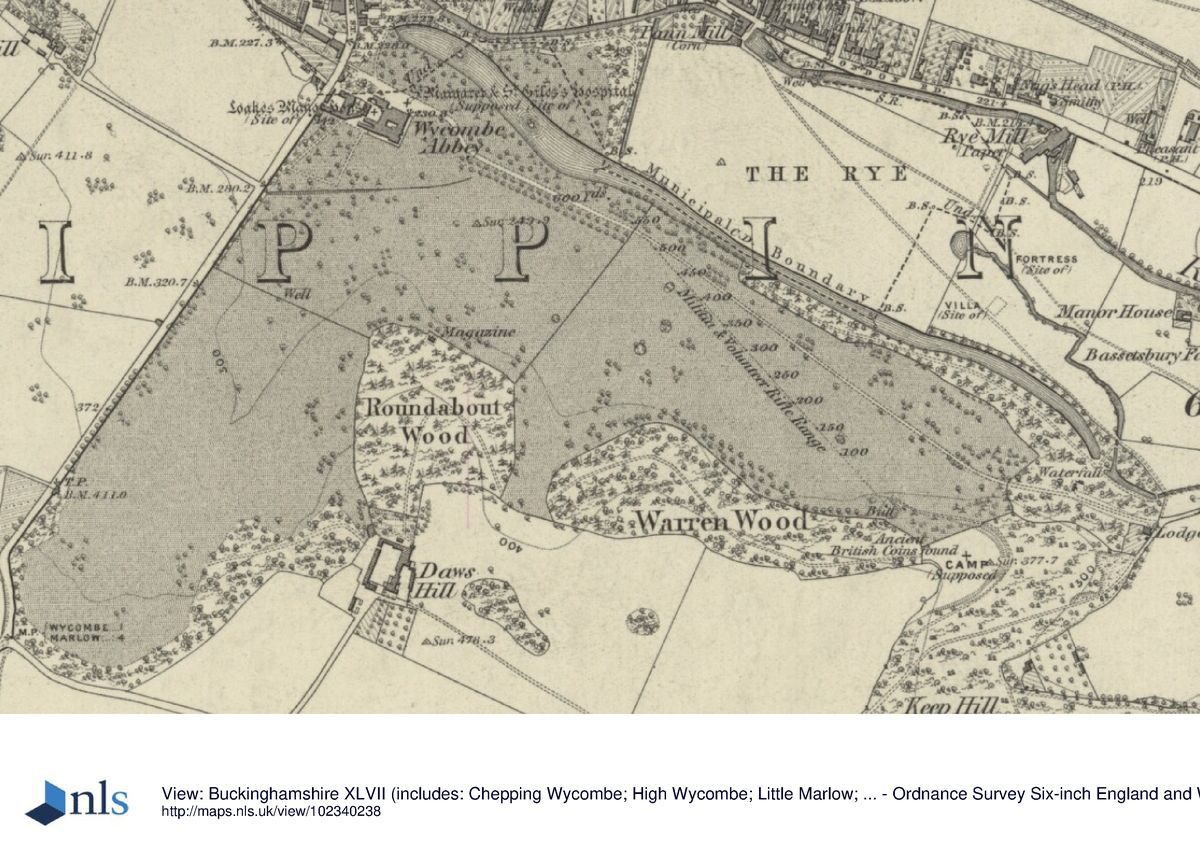
The site lies 200-300 metres south of High Wycombe High Street and the A40 London Road east of the High Street. The house is sited where two Chiltern valleys meet, the parkland running south and east from the house along these two valleys. The hilltops are wooded, and Daws Hill House lies amongst this woodland on the plateau south of the Abbey. The 70 hectare site is bounded on the west by Marlow Hill road, on the south by development along Daws Hill Lane and High Wycombe Air Station and to the north-east by The Rye open space. The setting to the north and west has developed in the last 100 years as the small 18th century market town has become a large urban centre. The site was directly connected to the High Street in the 19th century, but 20th century commercial and road development has masked and detached it from the old town area. The 18th/19th century fields to west and east have been reduced to the area of The Rye.
Some 700 metres south-east of Daws Hill House, a mature double avenue of lime trees flanked by large roundels of mature trees stands in parkland, extending for a further 750 metres south-east before terminating at the M40 motorway. The avenue lies outside the area here registered but was formerly connected to the landscape immediately surrounding the House by a drive through woodland and parkland which extended down the centre of the avenue. The area is now (1997) cut off from the House by a USAAF Air Base, but was planted in the early 20th century around the time that Daws Hill House superseded the Abbey as the Carringtons' main residence on the estate.
ENTRANCES AND APPROACHES
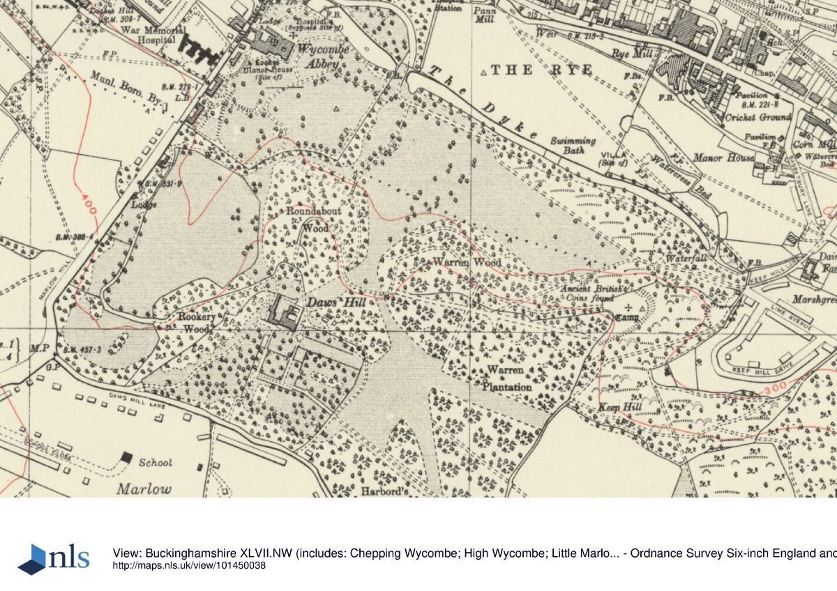
The approach from the modern gateway to the north, entrance front of the house is largely laid to tarmac and gravel, with modern island shrub beds. This area extends west along the north front of the house, leading to the service entrance west of the house, where a small, stucco and pebbledash lodge (early 19th century, Listed Grade II) lies, at the south end of St Mary Street. Of the two main 19th century entrances to the site (Ordnance Survey 1st edition 6" 1883), the course of the north drive has been most altered. It entered from the south side of the High Street through what appear to have been two burgage plots, over the River Wye, curving round the west end of The Dyke (see below: PARK) and up to the north front of the Abbey house. The High Street entrance was marked by two gothic lodges and a battlemented gateway (moved about 1900 to Marlow Hill). The north drive has been severely truncated by 20th century road development so that the late 20th century brick boundary wall and gateway is only 50 metres north of the north front of the house. The east drive is incomplete, entering the site 1.2 kilometres south-east of the house, from Keep Hill Road, past Keep Hill Lodge which is a single-storey, stucco, castellated building. The drive runs through the east woodland, interrupted by the 1960s Warren Wood Drive housing estate at the east end of the parkland. West of this development the drive crosses the park, running along the north edge of the lime avenue, above The Dyke, with views of the water, before curving north to arrive at the north front of the house.
An early 20th century drive runs across the southern end of the south park, entering off Marlow Hill through Wyatt's old High Street gateway and past one of the lodges (early 19th century, Listed Grade II) which was re-sited on Marlow Hill and renamed Rupert Lodge in about 1900. The drive follows the contours from the west to the east side of this valley, rising up through Rookery Wood to arrive at Daws Hill House on the plateau. Another 20th century drive gives access to Daws Hill House from the town across the west end of The Rye and The Dyke, running tortuously up through Roundabout Wood to the House. The Dyke was dammed at the entrance to the park to allow the new drive to cross it. In 1924 cast- and wrought-iron gates and railings (18th century; 19th century, Listed Grade II) salvaged from Cumberland and Buckingham Houses in London were erected. A third drive to Daws Hill created during this period runs to the House from Daws Hill Lane to the south. When the Carringtons moved to Daws Hill House in the early 20th century they retained most of the site, creating these drives through focused on their new house.
PRINCIPAL BUILDING
Wycombe Abbey (Listed Grade II*) is based around the early 17th century manor house of Loakes Manor: brick-built with three gable ends facing southward up the hill. To this Henry Keene added the three-storey square east block about 1755-1758 which faces the east park. James Wyatt gothicised this and added the north block about 1803-1804, building in local grey stone, re-facing the earlier building in the same material and castellating the roofs. Wyatt's north front is the principal entrance front, and is prominent from the town, looking down Queen Victoria Road. On the south side Wyatt created a stone arcade in front of the old manor house and an orangery with pointed arches. The views east and south-east from the house are the only surviving uninterrupted ones of the park and woodland. The view to the north has been truncated by the A40 re-routing and urban development, and that to the south by school buildings close to the south front of the house. The stables lay west of the house, but were demolished to make way for school buildings.
Daws Hill House (Listed Grade II), 600 metres south of the Abbey, became the second focus within this site after the third Lord Carrington remodelled the original farmhouse 1899-1901. The Carringtons extended this farmhouse and farmyard to create a sumptuous suite of rooms to entertain royalty. As they still owned the majority of the park, and Daws Hill lies at the south end of the 18th century area, it was relatively easy to reorganise the landscape around this building to make it part of the design. The drive system was rearranged to provide picturesque and convenient access to the House, and views from the House over the south park cut through between Roundabout and Rookery Woods. The courtyard gates (18th century, Listed Grade II) are wrought iron and came from the St Mary Street entrance to Loakes Manor.
GARDENS AND PLEASURE GROUNDS
There are no ornamental gardens around the Abbey, and the park runs right up to the Abbey house. Much of the area close to the house has been built on or tarmacked, but there are no ornamental garden features shown here on the 1st edition 25" Ordnance Survey map published 1882. Early 20th century ornamental features around Daws Hill House include formal yew hedges and terracing south and south-east of the House, and a lime avenue running south, aligned on the main, south entrance of the House, together with several sets of stone steps. The three wings of the House enclose a grassed courtyard, with wrought-iron gates on the fourth, north side, overlooking a further flat terrace north of the House. The House is encircled by the drive system.
PARK
The park extends along two valleys to the east and south of the Abbey house. The south park is enclosed by the valley sides. The valley bottom runs up the centre of the south park and was the site of the old Marlow Road before it was moved in the mid 18th century. The hollow it occupied is still visible in some places. The south end is still grazed pasture. The north end has been largely filled with school buildings since 1896, so that there is no view south along it from the north end, or from the north front of the house. The west boundary is defined by a narrow line of trees south of the Arts and Crafts-style boarding houses about 1900) on the boundary. There are several other school buildings on this boundary, south of the boarding houses. The south edge of the south park is defined by a belt of trees and bounded by Daws Hill Lane, and the east by Rookery and Roundabout Woods. On the north-east edge below Roundabout Wood, 250 metres south of the house is an icehouse with a flint facade, now bricked up, possibly dating from the 1760s landscaping or else by Wyatt, about 1802.
The east park, sited on a north-facing slope, is bounded to the north by The Dyke, a long, narrow stretch of water created in the 18th century, possibly by Brown, during the landscaping of the park. South of The Dyke is an adjacent strip of woodland which widens out at the east end where the old drive from London runs through it. An ornamental flint gardener's cottage lies in this woodland, overlooking the site of the grotto (filled in, late 20th century) and the cascade at the east end of The Dyke. The layout is similar to the south park as the parkland is bounded by woodland on three sides, focusing the view towards the Abbey house at the west end. However, 20th century developments in the park, including the Warren Wood Drive development, Second World War terracing by the US Air Force, and terraces for games pitches have all been inserted. The Dyke and the woodland adjacent to the south remains largely undeveloped, although a large sports pavilion has been built adjacent to The Dyke on The Rye (outside the site boundary). A walk runs through the trees along the south side of The Dyke from the west end, arriving at the 18th century cascade where the water drops about 5 metres to its natural level and becomes a stream once more. The remains of the old brick boundary wall cross the stream where it leaves the east end of the site. The northern edge of The Dyke is now part of The Rye open space, and has been paved. A line of mature yews and other evergreens runs along the eastern end. At its western end The Dyke has been truncated to accommodate the A40 road alteration in the town centre. A dam which carries the drive from the town up to Daws Hill was built across it in the early 20th century. Remnants of the park planting north and north-east of the Abbey house remain on what is now highway land and public open space, including ornamental conifers and several mature yews. Both halves of the park have suffered from 20th century development, but still largely retain their 18th century landscape character.
The main views extend north and east from the park, woodland and The Dyke. Originally the parish church was prominent in views from the Abbey and the surrounding park, but it is now largely obscured by urban development. The hillside north and north-east of the town centre draws the eye north and east across The Rye and east down the Rye valley.
The woodlands are still in good condition. They have drives and paths running though them, and act as visual backstops for the parkland.
The land adjacent to Daws Hill House is partly woodland of the Abbey landscape (to the west and north), but also 20th century designed land to the south and east of the House. The park had been extended to the south and east in wide swathes by 1900 (Ordnance Survey), and by 1926 (Ordnance Survey) the area south of the House was formed into a more formal designed landscape. Much of the garden still survives around the House, but the extended park has largely been built over. The woodland east of Daws Hill House was extended in about 1900, and this still remains, merging into the earlier woodland.
The second Earl of Shelburne, having been a benefactor to the town, was permitted to close the old road to Marlow and the right of way was extinguished. The town council also surrendered land on a 999-year lease between the town and the Abbey house. It was then possible to create the new road to Marlow west of the house, on its current course, and to develop a private park east and south of the house. The third Earl of Shelburne employed Lancelot Brown at Bowood House in the 1760s. A contract of 1762 exists at Bowood, for the improvement of the grounds there, but no contract seems to survive for Loakes Manor. There are however accounts at Bowood covering trees and shrubs bought by Brown specifically for Loakes Manor. It is probable that Brown carried out improvement works to the landscape at Loakes, creating The Dyke and fashioning the woodland and parkland in the east and south valleys. At this time the walled garden was created north-west of the house, the stream was dammed to create The Dyke, and a ha-ha was created between the house and parkland, with potted orange trees on the terrace in spring and summer. There are references in the Bowood archives to a menagerie which Shelburne kept at first at Loakes Manor, and later moved to Bowood.
KITCHEN GARDEN
The 18th century kitchen garden lay north-west of the house, reached by a tunnel under St Mary Street. High Wycombe College now covers the site.
REFERENCES
K A Walpole, From One Generation to Another (nd), pp 1-10, 17-18
N Pevsner and E Williamson, The Buildings of England: Buckinghamshire (1994), pp 390-392
Wycombe Abbey School, 1896(1996, (booklet 1996)
Maps
Diversion of footpath and highway adjacent to Wycombe Abbey estate, 1808 (Q/H/24), (Buckinghamshire Record Office)
Diversion of footpath next to kitchen garden, 1808 (Q/H/27), (Buckinghamshire Record Office)
Further diversions adjacent to Carrington estate, 1818 (Q/H/47 & 48), (Buckinghamshire Record Office)
OS 6" to 1 mile: 1st edition published 1883
2nd edition published 1900
1926 edition
OS 25" to 1 mile: 1st edition published 1881-1882
2nd edition published 1899
Description written: 1997
Amended: May 1999
Edited: September 2000
- Visitor Access, Directions & Contacts
Directions
On the south side of Wycombe.
Owners
Wycombe Abbey School
- History
The following is from the Register of Parks and Gardens of Special Historic Interest. For the most up-to-date Register entry, please visit the The National Heritage List for England (NHLE):
www.historicengland.org.uk/listing/the-list
HISTORIC DEVELOPMENT
The house may be on the site of the medieval Hospital of St Margaret and St Giles. By the early 17th century Loakes Manor house (the original name of the site) had superseded the hospital. In 1700 Henry Petty, first Earl of Shelburne bought the estate. His nephew John, second Earl of Shelburne donated several civic buildings to the town during the 1750s, including the Guildhall and the Market House. The Guildhall (1757) was designed by Henry Keene, who altered the Jacobean manor house. The second Earl died in 1761 and was succeeded by William, the third Earl, who improved the grounds, probably using Lancelot Brown (1716-1783). In 1798 the third Earl sold Loakes Manor to Robert Smith, newly created Lord Carrington, who employed James Wyatt to remodel and extend Loakes in the Gothic style about 1803-1804, and who renamed the estate in more Romantic vein, 'Wycombe Abbey'. Humphry Repton (1752-1818) may have been employed here, but his input is unknown.
The Abbey house and 30 acres (12.5 hectares) of land were sold in 1896 to a syndicate who created Wycombe Abbey School. The Carringtons moved in about 1901 to the sumptuously converted and extended farm buildings now called Daws Hill which the first Lord Carrington had enlarged and given sham towers, and the focus of the landscape shifted from the Abbey house to Daws Hill House. In 1928 Daws Hill House, its associated landscape and the remainder of Wycombe Abbey Park were sold to the school. During the Second World War the US Air Force occupied Wycombe Abbey and sited buildings on terraces they created in the east valley. Various school buildings and structures have been built in the grounds, and a post-war development of housing sited at the east end of the east park.
- Associated People
- Features & Designations
Designations
The National Heritage List for England: Register of Parks and Gardens
- Reference: GD1599
- Grade: II
Features
- Icehouse
- Lake
- Astrolabe
- House (featured building)
- Now School
- Description: Wycombe Abbey is based around the early-17th century manor house of Loakes Manor: brick-built with three gable ends facing southward up the hill. To this Henry Keene added the three-storey square east block about 1755-1758. James Wyatt gothicised this and added the north block about 1803-1804, building in local grey stone, re-facing the earlier building in the same material and castellating the roofs.
- Earliest Date:
- Latest Date:
- Avenue
- Description: Some 700 metres south-east of Daws Hill House, a mature double avenue of lime trees flanked by large roundels of mature trees stands in parkland.
- Approach
- Description: The approach from the modern gateway to the north, entrance front of the house is largely laid to tarmac and gravel, with modern island shrub beds.
- Gate Lodge
- Description: A small, stucco and pebbledash lodge lies, at the south end of St Mary Street.
- Earliest Date:
- Latest Date:
- Drive
- Description: The north drive has been severely truncated by 20th century road development.
- Drive
- Description: The east drive is incomplete.
- Gate Lodge
- Description: Keep Hill Lodge is a single-storey, stucco, castellated building.
- Avenue
- Description: Lime avenue.
- Drive
- Description: An early 20th century drive runs across the southern end of the south park.
- Earliest Date:
- Latest Date:
- Gateway
- Description: The old High Street gateway.
- Gate Lodge
- Description: Rupert Lodge.
- Earliest Date:
- Latest Date:
- Railings
- Description: In 1924 cast- and wrought-iron gates and railings salvaged from Cumberland and Buckingham Houses in London were erected.
- Earliest Date:
- Latest Date:
- Building
- Description: Daws Hill House, 600 metres south of the Abbey, became the second focus within this site after the third Lord Carrington remodelled the original farmhouse 1899-1901.
- Gate
- Description: The courtyard gates are wrought iron and came from the St Mary Street entrance to Loakes Manor.
- Earliest Date:
- Latest Date:
- Courtyard
- Description: The three wings of the House enclose a grassed courtyard, with wrought-iron gates on the fourth, north side.
- Terrace
- Water Feature
- Description: The Dyke, a long, narrow stretch of water created in the 18th century, possibly by Brown, during the landscaping of the park.
- Garden Building
- Description: An ornamental flint gardener's cottage lies in the woodland, overlooking the site of the grotto.
- Cascade
- Description: 18th century cascade where the water drops about 5 metres to its natural level.
- Earliest Date:
- Latest Date:
- Ha-ha
- Stream
- Description: The remains of the old brick boundary wall.
- Boundary Wall
- Description: The remains of the old brick boundary wall.
- Dam
- Description: A dam which carries the drive from the town up to Daws Hill.
- Kitchen Garden
- Description: High Wycombe College now covers the site of the kitchen garden.
- Key Information
Type
Park
Purpose
Ornamental
Principal Building
Education
Survival
Extant
Hectares
70
- References
References
- {English Heritage Register of Parks and Gardens of Special Historic Interest} (Swindon: English Heritage 2008) [on CD-ROM] Historic England Register of Parks and Gardens of Special Historic Interest
- Pevsner, N and Williamson, E {The Buildings of England: Buckinghamshire} (1994) pp 390-392 The Buildings of England: Buckinghamshire