Introduction
Hughenden Manor has mid-19th century formal gardens and woodland walks covering 2 hectares. The gardens are situated within a park which at its most extensive covered about 60 hectares, including woodland and agricultural land.
Terrain
The park falls away to the east and south.www.historicengland.org.uk/listing/the-list
A 19th century landscape park, extended and improved for the Prime Minister and author Benjamin Disraeli in the mid- to late-19th century, at which time formal gardens were created around the house.
DESCRIPTION
LOCATION, AREA, BOUNDARIES, LANDFORM, SETTING
Hughenden Manor is located 2.5km north of the centre of High Wycombe, at the northern extremity of the town, in the heart of the Chiltern Hills. The c 60ha site lies at the south end of the Naphill ridge. The park falls away to the east, with level lawns to the south and north of the house, and further parkland gently dropping away south of the house. The north-west of the site is largely wooded, in parts hanging woodland, situated on the west shoulder of the chalk escarpment. The site is bounded on the east by the A4128 High Wycombe to Great Missenden road. The south boundary is formed of suburban housing and light industrial units. The west and north boundaries are adjacent to farmland. Thus its setting to the south is urban, but to the north it is still agricultural and wooded, spread across steep scarps and more gentle rolling hillsides and valleys.
ENTRANCES AND APPROACHES
The main entrance is at the north-east corner of the park, marked by a substantial flint and brick lodge north of the drive standing on the A4128 Hughenden Valley road. The 500m drive almost immediately crosses the stream which runs south through the park, over a small, single gothic-arch stone bridge dated 1830. It then curves north around the church and churchyard, passing close to the northern boundary of the site, before turning south-west, becoming considerably steeper as it approaches the house via the wooded pleasure grounds.
The northern half of another main C19 drive survives as the access to Middle Lodge. It starts at Middle Lodge, sited at the pre-1847 southern boundary, progressing through the north park, to enter the wooded pleasure grounds before arriving at the north front of the house. The southern half has disappeared into the parkland. In the C19 this drive entered past a lodge (now demolished) in the middle of the southern park boundary, bisecting the whole park.
In the south-east corner of the park, Wycombe Lodge (mid C19, listed grade II) is in similar neo-Tudor style to the north-east lodge. Wycombe Lodge lies at the beginning of another 1km long drive north which led along the length of the park. Part of this drive ran close to the stream and lake. A public footpath now reflects the line of this drive.
The two southern entrances gave access to the park from High Wycombe to the south. The drives had a changing view of almost the whole park and surrounding hillsides as they progressed north, running almost parallel in the northern half of the park. The house came into view to the north-west as the main drive traversed the hillside on which the house stands.
PRINCIPAL BUILDING
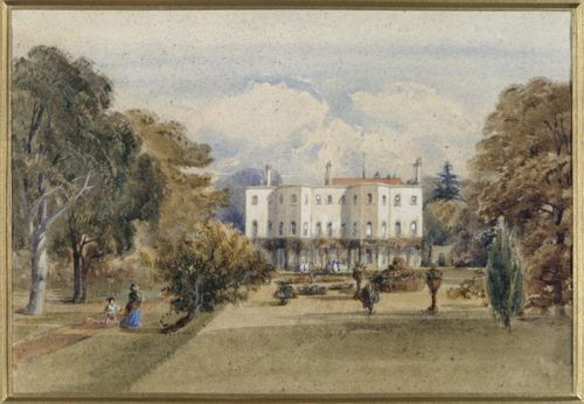
Hughenden Manor (listed grade I) lies in the north-west corner of the site, facing south, its principal entrance on the north front. Between 1737 and the 1830s it was gradually enlarged from a farmhouse to an unpretentious white stucco house of three storeys with two canted bay windows and a verandah. The house is probably largely of early C19 origin.
Benjamin Disraeli remodelled the interior and exterior in 1863 using the architect Edward B Lamb. Disraeli wrote in 1863 'we have restored the house to what it was before the Civil Wars, and we have made a garden of terraces, in which cavaliers might roam, and saunter, with their ladye-loves!' (National Trust 1995). Lamb's principal exterior work was re-facing the house in a kind of mock-Jacobean brickwork. While he remodelled the interior in Gothic style, he also added to the main, north entrance front, a brick loggia, glazed in, with an encaustic tile floor. A large wing was attached at right angles to the west of the house in 1900 by Coningsby Disraeli.
The stable block lies 100m north of the house, with a coach house and garden wall attached (E B Lamb 1866-8, listed grade II), now (1997) a shop and offices. They occupy the site of earlier farm buildings.
GARDENS AND PLEASURE GROUNDS
The 2ha gardens and pleasure grounds surround the house closely. An extended arm of the pleasure grounds runs south from the house and garden along the west edge of the park. North of the house is a level forecourt with oval, gravel drive/turning circle; the centre panel is lawn with specimen conifers recently replanted, the forecourt having been similarly planted during Disraeli's time. This area is screened on the east by mature trees with paths between.
A straight terrace runs along the south front of the house in the South Garden. A C19 Regency-style iron loggia was attached to the house on this terrace until it was removed c 1939. The terrace, with statues, and vases designed by Mary-Anne Disraeli, arranged along it, drops down to a flat, rectangular parterre with a path around its perimeter. This South Garden is largely grass with seasonal bedding beds in it, a 1990s restoration of an 1880s formal bedding scheme. At the southern end of the parterre is a small, two-tier stone fountain and bedding beds cut into the turf. The south garden was screened to the east and west by mature trees before the storm of 1990. Now the view to the west has been opened up by the loss of these trees, revealing a wide view towards Great and Little Tinker's Woods and The Monument, dedicated to Isaac Disraeli, between them.
South of the parterre is the fenced boundary with the park, with a view from the parterre into the park. The extension of the pleasure grounds, Beech Walk, runs south from the parterre along the edge of the ridge as a narrow belt 300m long. At its southern end it returns east for 150m to meet Middle Lodge, this line marking the south boundary of the early C19 park. This walk has ornamental shrubs and a central path giving views to west and east across the two valleys, but it has lost many of its mature trees.
PARK
The park is largely still pasture/grass, well treed with clumps and singles of various mature exotic and native species. A shallow seasonal stream winds through the park at the bottom of the valley, from north to south, and is dammed in several places to widen it out. About half way through the park it widens into a small lake with an island in the middle. The parkland drops steeply to the east and south-east from the plateau the house sits on, but elsewhere is gently rolling, without such steep slopes. On the east boundary of the park is a sports ground with bowling green and sports pitches, and modern clubhouse.
At the north end of the park is the church of St Michael and All Angels (listed grade II*), of medieval origin but largely rebuilt 1874-5 by Sir Arthur Blomfield. It lies in its own churchyard within the park, where Disraeli is buried beneath the family monument (listed grade II). Church House (listed grade II) lies close by to the south-west: C17 almshouses originally, it has been much remodelled.
The parkland seems to have been created south and east of the house in the early C19. Small fields south of the church were then amalgamated, and more land to the east included in the park. The stream was moved westwards and the ponds created. Disraeli added the southern half of the park in the 1870s. The park is now divided into two halves, to north and south, although both are of similar character. The division reflects the historical boundaries: Ford Lane, now disused, marked the boundary between the earlier park and Disraeli's southern addition.
OTHER LAND
An area of designed woodland lies north-west of the house, incorporating Disraeli's German Forest. The German Forest was designed to be reminiscent of the set walks at Ems and other German watering places, and was planted c 1861. Within it Disraeli's wife, Mary-Anne, developed a network of paths through existing beech wood. The paths are largely cut along the contours, and bordered by conifers, with laurel and yew at the path edges.
The area is divided into three woodland sections which today do not have strong boundaries between them. That nearest to the house drops sharply to the valley bottom, with several paths through it. It seems to have been parkland in the late C19, with relatively densely planted trees, edged with conifers on its south and west boundaries. Part of this wooded area may have been included in the approach to the German Forest. Several of the paths through this area lead north-west to the second section, Hanging Wood, the initial section of the German Forest. It lies along a steep slope, with two main paths continuing through it from the first section of woodland. The upper path, running along the contour just below the top of the slope, is edged with laurels and yews, and commands a fine view south towards Great and Little Tinker's Woods in the distance. Yews were planted along the bottom of Hanging Wood, which was extended to enclose the lower path.
Hanging Wood is a narrow approach to the third woodland section, the main section of the German Forest, comprising Flagmore Wood and a small strip of the north side of Common Wood. Mary-Anne's paths wind through Flagmore Wood at different heights on the south-facing slope it occupies. Much of the shrubby path edging survives, together with some of the exotic conifers including Wellingtonia, Douglas fir, larch, Norway spruce and the native Scots pine. A narrow planting of larch still exists along the north and east boundary of Flagmore Wood.
The Monument (E B Lamb 1862, listed grade II) lies 1.5km south-west of the main site near the top of a hill in a gap between the two Tinker's Woods. It is an elaborate, 17m high Bath stone pillar erected by Mary-Anne Disraeli to the memory of her husband's father Isaac. The Monument is an outlying feature designed to draw the eye from various parts of the garden and park across the valley to the west to the wider landscape to the west and south-west.
KITCHEN GARDEN
The kitchen garden lies north of the house on a south-east-facing slope. It is an irregular quadrangle, attached to the east side of the stable yard and bounded largely by brick and flint walls (listed grade II). There is a brick entrance arch at the south-west corner. The south wall is lower than the others, providing a view of the park and eastern hillside beyond the Hughenden road. The C19 cruciform path layout has been reinstated in the 1990s, and fruit trees and bushes planted in the centre and against the walls.
North of the kitchen garden is a smaller, walled area, now a yard with a modern glasshouse against the north wall. On its west wall is a brick-pillared gateway. North of this is a small walled service yard with a range of open timber sheds and potting shed.
REFERENCES
Country Life, 1 (1 May 1897), pp 463-5; 113 (21 May 1953), pp 1604-7; (28 May 1953), p 1698; 171 (28 January 1982), pp 216-17
Hughenden Manor, guidebook, (National Trust 1955)
N Pevsner and E Williamson, The Buildings of England: Buckinghamshire (1994), pp 405-6
The Hughenden Estate Landscape Restoration Plan, (Bronwen Thomas for the National Trust, 1995)
Maps
Tithe map for Hughenden parish, 1844 (220), (Buckinghamshire Record Office)
Plan of the Hughenden Estate, 1846 (from sale particulars) (IR/M29/6), (Buckinghamshire Record Office)
Hughenden Inclosure map, 1859 (PR 110/26/2), (Buckinghamshire Record Office)
OS 6" to 1 mile: 1st edition published 1883
2nd edition published 1900
1926 edition
OS 25" to 1 mile: 1st edition published 1881-1882
2nd edition published 1898
Description written: 1997
Edited: October 1999
- Visitor Access, Directions & Contacts
Telephone
441494755565Access contact details
The park is open all year. Gardens are open March - October, 11am to 5pm, Wed/Thur/Fri/Sat/Sun, also 1 Dec to 16 Dec, Sat/Sun 11am to 4pm. Please see: http://www.nationaltrust.org.uk/place-pages/181/pages/opening-times-calendar
Directions
1.5 miles north of High Wycombe on the west side of A4128.
Owners
The National Trust
- History
The following is from the Register of Parks and Gardens of Special Historic Interest. For the most up-to-date Register entry, please visit the The National Heritage List for England (NHLE):
www.historicengland.org.uk/listing/the-list
HISTORIC DEVELOPMENT
The manor was owned by the Dormers of Wing and West Wycombe in the 16th and 17th centuries. The Savages owned the manor from 1737, when they gradually began to extend an existing farmhouse. Over the next 111 years it passed through the hands of various members of the family, during which time a small park appears to have been created to the south and east of the farmhouse, probably during the early 19th century (Plan of the Hughenden Estate, 1846). In 1847 the estate was bought by Benjamin Disraeli who lived here until his death in 1881. He had grown up at Bradenham Manor several kilometres away and was familiar with the Chilterns. He bought Hughenden in order to provide a suitable country home for himself as Leader of the Tory party and subsequently Prime Minister. Disraeli expanded the park considerably and had a formal garden created south of the house. His wife, Mary-Anne, was influential, supervising much of the landscape and garden works in her husband's absence, and designing part or all of the so-called German Forest in the 1860s. Disraeli was succeeded by his nephew, Major Coningsby Disraeli, then Coningsby's niece Mrs Calverley.
In 1946 the estate was given to the National Trust, in which ownership it remains (1997).
Period
- Post Medieval (1540 to 1901)
- Victorian (1837-1901)
- Associated People
- Features & Designations
Designations
The National Heritage List for England: Register of Parks and Gardens
- Reference: GD1260
- Grade: II
Style
Formal
Features
- Terrace
- Lawn
- Island Bed
- Mixed Border
- Sculpture
- Manor House (featured building)
- Description: An existing farmhouse was extended after 1737.
- Earliest Date:
- Key Information
Type
Park
Purpose
Ornamental
Principal Building
Domestic / Residential
Period
Post Medieval (1540 to 1901)
Survival
Extant
Hectares
60
Open to the public
Yes
Civil Parish
Hughenden
- References
References
- {English Heritage Register of Parks and Gardens of Special Historic Interest} (Swindon: English Heritage 2008) [on CD-ROM] Historic England Register of Parks and Gardens of Special Historic Interest
- Pevsner, N and Williamson, E {The Buildings of England: Buckinghamshire} (1994) pp 405-406 The Buildings of England: Buckinghamshire
- Rutherford, Sarah {Hughenden: Chalk Stream Conservation Plan (with HEA)} (2014) Hughenden: Chalk Stream Conservation Plan (with HEA)