Introduction
Bradenham Manor is a mid- to late-17th century country house with a 17th-century park and an early-18th century terraced garden, occupying a total of approximately 14 hectares.
Terrain
The site occupies a hillside descending westwards into the valley bottom.www.historicengland.org.uk/listing/the-list
A late 17th century country house with a late 17th century or early 18th century terraced garden, and park.
DESCRIPTION
LOCATION, AREA, BOUNDARIES, LANDFORM, SETTING
Bradenham Manor lies 6km south of Princes Risborough and 5km north-west of High Wycombe, in the heart of the Chiltern Hills. The c 14ha site is bounded to the east by The Coppice woodland and by the wooded remains of Naphill Common. To the west it is bounded by the village of Bradenham and associated common land which was once part of Naphill Common before the construction of the garden divided it into two. To the north the site is bounded partly by the C19 Bradenham to Walter's Ash road and beyond this, and to the south, by agricultural land. The site occupies a hillside descending westwards into the valley bottom in which runs the Bradenham Road connecting Princes Risborough with High Wycombe. The setting is wooded and agricultural, with the village of Bradenham adjacent and long views extending north-west and south-east along the valley and westwards across the valley. A view extends 2km south to the tower of St Lawrence's church at West Wycombe, standing on top of West Wycombe Hill, with a further view extending north-east to a clearing in woodland (partly occupied by Royal Air Force development) beyond the Queen's Gap cut through Falconer's Hill Wood. Nearby lie the landscape parks of West Wycombe Park (qv), Hughenden Manor (qv) and Hampden House.
ENTRANCES AND APPROACHES
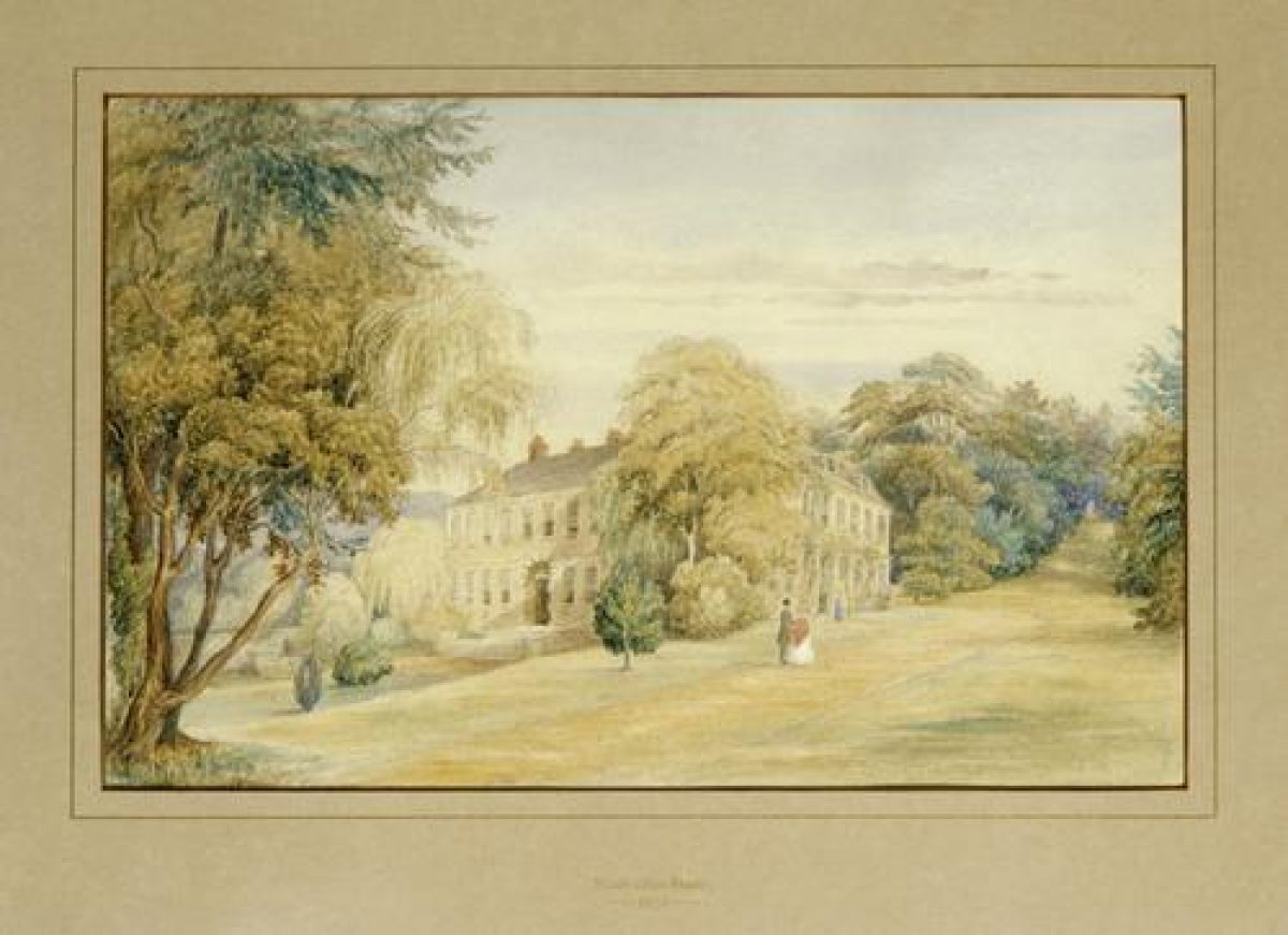
The main approach to the house leaves the Bradenham to Walter's Ash road 150m west of the house and crosses the Common via a cobbled drive, arriving at the rectangular forecourt on the west front of the house. The forecourt entrance is marked by a screen of iron gates and railings, and brick and stone gate piers with ball finials (late C17/early C18, listed grade II), with a low brick wall supporting the railings. The drive crosses the forecourt to a gravel apron from which moulded stone steps, flanked by carved reclining dogs, lead up to the central front door. The drive is flanked by panels of lawn, with the remains of a wide border running along the north side of the northern panel, below a brick wall separating the forecourt from St Botolph's churchyard to the north. A doorway leads through the wall to the churchyard. The south side of the forecourt is bounded by an earth terrace leading up to the garden to the south.
A further approach enters 200m north-east of the house, also off the Bradenham to Walter's Ash road, passing a single-storey brick lodge (C19), with a C20 lodge adjacent. From here the drive runs south, flanked by the park to the east and former orchards to the west, passing through the stable yard to the east, service front of the house.
PRINCIPAL BUILDING
Bradenham Manor (c 1670, listed grade II*) was rebuilt, probably for Sir Edmund Pye and his wife Catherine Lucas, incorporating the timber-framed remains of a C16 house in the south wing overlooking the garden. The two-storey brick house was altered during the mid C19 and early C20, with the addition of a large service wing to the north. The foundations of a south-west wing, belonging to the C16 house, survive south of the forecourt. Service buildings enclose a yard to the east of the house.
GARDENS AND PLEASURE GROUNDS
The main gardens lie to the south and south-east of the house, this area being surrounded to the west, south and partly to the east by a brick retaining wall (possibly C17), and divided into two main sections: that to the west being largely laid to terraced open lawns, and that to the east being occupied by The Wilderness, divided into four main compartments by grass paths.
The western half of the garden is entered via the garden door set in the centre of the south front, leading straight out onto a path running across the south front. From here the rectangular upper lawn extends 100m south to a raised grass terrace projecting southwards, connecting the lower lawn below to the west with The Wilderness above to the east. The southern boundary of the terrace is formed by the brick retaining boundary wall standing adjacent to a footpath connecting the northern section of Naphill Common with the southern section surrounded by Bradenham village. From this elevated position views extend south and south-west along the valley, terminated by West Wycombe church tower on West Wycombe Hill (the upper portion and Golden Ball having been added in the mid C18).
The west end of the path along the south front of the house leads to a set of stone steps leading west from the upper lawn down a grass bank to a stone seat lying at the northern end of the narrow rectangular lower lawn. The lower lawn is flanked to the east by the grass bank connecting it to the upper lawn, to the north by a grass bank sloping down to the forecourt, and to the west by a yew hedge beyond which extends a parallel grass path. The path is supported to the west, above the Common, by the brick retaining boundary wall, this forming the western garden boundary with the Common beyond and allowing uninterrupted views westwards over the Common and valley to the hillside beyond. During most of the C20, until the 1980s, the lower lawn was laid out as a parterre with formal flower beds planted with seasonal bedding and herbaceous plants (CL 1932). The north-west corner of the lower lawn is planted with a group of mature conifers, the southern end being planted informally with mature trees including a large cedar.
East of the upper lawn lies The Wilderness, an area of formal woodland rising up the hillside via earth terraces, divided into four quarters by straight walks, the resultant compartments being thickly planted with mature yews and other trees. Three grass walks extend north and north-east from the southern end of The Wilderness, lying 150m south of the house, supported above the Common below to the south by the extension east of the brick retaining boundary wall supporting the curved raised terrace at the south end of the upper lawn. The westernmost of the three walks extends north alongside and above the upper lawn, supported by a grass bank, meeting at its northern end the path along the south front at the south-eastern corner of the house. The central walk, Archery Furlong, extends north-east, flanked on either side by two wooded compartments, aligned to the north-east on the Queen's Gap cut through woodland on the upper hillside lying 500(600m distant. The easternmost walk, Ranger's Walk, is bounded to the west by wooded garden compartments and to the east partly by the retaining boundary wall (along the southern half) and partly by the remains of a C19 ha-ha (along the northern half), this forming the northern section of the eastern garden boundary with the Common beyond. Ranger's Walk extends c 350m north-east beyond the northern end of The Wilderness, as a terrace walk along the hillside flanked by mature woodland, with occasional views west across Bradenham village to the valley and hillside beyond.
A cross walk dividing the northern and southern compartments extends east up the hillside from the upper lawn, to which it is set at 90 degrees. A further cross walk extends east up the hillside from the south-east corner of the house, at the northern boundary of the woodland compartments, to meet Archery Furlong 75m east of the house, with an extension of this linking Archery Furlong and Ranger's Walk.
North-west of the house lies a small rock garden feature, enclosed by walls.
PARK
The park, divided into several paddocks and laid to pasture, extends north-east from the house and Wilderness up the hillside. It is bounded to the east and north by woodland. Archery Furlong Walk in The Wilderness is aligned across the park to the north on the Queen's Gap, which is cut through the northernmost woodland. This gap is shown on the Bradenham Tithe map (1847). It is said (National Trust report 1977) that the road constructed for Queen Elizabeth's visit in 1566, leading down from Queen's Gap, is still visible as a level strip across the parkland, possibly having turned west when it reached what is now the broad, ramped walk down from the north end of Archery Furlong to the former C16 main entrance to the house on its south front (now the garden entrance). The park is divided towards the northern end by the C19 Bradenham to Walter's Ash road, with a car park placed at the park's southern end, enclosed by mature trees.
KITCHEN GARDEN
The kitchen garden, partly surrounded by brick walls, is divided into several sections lying to the north of the house, largely laid to grass, with areas of orchard trees. It is bounded to the west by the churchyard, to the east by the north drive and to the north by a brick wall standing adjacent to the road beyond. A C19 gardener's cottage stands on the east boundary of the walled gardens. It is possible that a former main entrance to the site (ie before the creation of the drive across the Common and the forecourt in the C17/C18) entered via a blocked-up gateway in the north boundary wall of this area, leading to the north front of the C16 house (National Trust report 1977).
REFERENCES
John James, The Theory and Practice of Gardening (1712), chap 6
G Lipscombe, The History and Antiquities of the County of Buckinghamshire (nd, c 1847), pp 553-5
Country Life, 72 (6 August 1932), pp 154-9
ICT Ltd, The History of Bradenham Manor (nd, c 1960s/70s)
J Sales, Bradenham Manor, (unpublished report for the National Trust 1977)
N Pevsner and E Williamson, The Buildings of England: Buckinghamshire (1994), pp 188-9
Maps
Tithe map for Bradenham Parish, 1847 (Buckinghamshire Record Office)
OS 6" to 1 mile: 1st edition published 1885
3rd edition published 1922
OS 25" to 1 mile: 1st edition surveyed 1874
3rd edition published 1925
Description written: December 1998Edited: June 1999
- Visitor Access, Directions & Contacts
Telephone
0844 800 1895Website
http://www.nationaltrust.org.ukDirections
4 miles north-west of High Wycombe.
Owners
The National Trust
Heelis, Kemble Drive, Swindon, SN2 2NA
- History
The following is from the Register of Parks and Gardens of Special Historic Interest. For the most up-to-date Register entry, please visit the The National Heritage List for England (NHLE):
www.historicengland.org.uk/listing/the-list
HISTORIC DEVELOPMENT
In 1505 Bradenham Manor and its estate was sold to Andrew Windsor, who was knighted at Henry VIII's coronation in 1509, the estate remaining in this family for nearly 140 years. Sir Andrew was created Lord Windsor in 1529, being succeeded in 1543 by his son William, the second Lord Windsor, who in about 1550 built Bradenham House, a building considerably larger than the present manor house. In 1566 Queen Elizabeth visited Bradenham, on her return to London from visiting the University of Oxford. A new road was cut through the hillside above the village, the supposed course being known as the Queen's Gap.
In 1642 the estate was sold to Sir Edmund Pye, whose daughter Marjery (or Martha), the wife of John, Lord Lovelace of Hurley, inherited it at her father's death in 1673. It seems that the house was rebuilt at this time and it is likely that the terraced garden was laid out at the same time or slightly later. Lady Lovelace's daughter, Martha (d 1745), succeeded to the title of Baroness Wentworth, and on the death of her mother in the late 17th century became Lord of the Manor of Bradenham. In 1787 Bradenham was sold out of the Lovelace-Wentworth family, passing through several hands before in 1829 being leased to Isaac D'Israeli, father of the statesman and author Benjamin Disraeli (1804-1881), who omitted the apostrophe from the family name and was later created first Earl of Beaconsfield. Here Disraeli wrote parts of his novels 'Sybil' and 'Coningsby'. Mr D'Israeli died in 1849, his son having purchased the nearby Hughenden Manor in 1848. Disraeli, in his last novel 'Endymion' (1880), described Bradenham (which he referred to as Hurstley) as he remembered it in his youth, in the early 1830s, mentioning 'once stately' grounds and 'glade-like terraces of yew trees, which give an air of dignity to a neglected scene'. In 1847 the estate was settled on the Hicks family, remaining with John Hicks Tempest and his wife from 1854 to 1947 when it was bought by Ernest Cook, being taken over by the National Trust in 1956. The Manor is presently (1998) used as a company training centre.
- Features & Designations
Designations
The National Heritage List for England: Register of Parks and Gardens
- Reference: 4173
- Grade: II
Features
- Lawn
- Description: 17th-century park
- Garden Terrace
- Description: early-18th century terraced garden,
- Manor House (featured building)
- Description: mid- to late-17th century country house was rebuilt, probably for Sir Edmund Pye and his wife Catherine Lucas,
- Earliest Date:
- Latest Date:
- Gardens
- Description: he main gardens lie to the south and south-east of the house,
- Wall
- Description: a brick retaining wall
- Path, Wilderness
- Description: to the east being occupied by The Wilderness, divided into four main compartments by grass paths
- Entrance
- Description: The western half of the garden is entered via the garden door
- Path, Yew Hedges
- Description: A yew hedge beyond which extends a parallel grass path.
- Woodland
- Description: an area of formal woodland rising up the hillside via earth terraces
- Woodland, Parkland
- Description: The park is divided into several paddocks and laid to pasture It is bounded to the east and north by woodland
- Kitchen Garden, Wall
- Description: The kitchen garden, partly surrounded by brick walls,
- Key Information
Type
Park
Purpose
Ornamental
Principal Building
Commercial
Survival
Extant
Hectares
14
Electoral Ward
Bledlow and Bradenham
- References
References
- {English Heritage Register of Parks and Gardens of Special Historic Interest} (Swindon: English Heritage 2008) [on CD-ROM] Historic England Register of Parks and Gardens of Special Historic Interest
- Pevsner, N. and E. Williamson, {The Buildings of England: Buckinghamshire} (London: Penguin, 1994) pp 189-189 The Buildings of England: Buckinghamshire
- Bernamont, Len {Bradenham Manor Gardens Conservation Plan} (2007) Bradenham Manor Gardens Conservation Plan