Introduction
West Wycombe Park has an 18th-century rococo landscape garden of 18.5 hectares, situated within a larger landscape park occupying about 135 hectares. The gardens are associated with an agricultural estate of about 2000 hectares, which is now in separate ownership.
Terrain
The northern section of the site on either side of the River Wye is relatively flat with a slight fall to the east; the southern section rises up the rolling hillside to the south from the river valley.www.historicengland.org.uk/listing/the-list
A complex, well-preserved C18 landscape park and pleasure grounds around an C18 Palladian villa. Some later advice by Humphry Repton, 1790s. The site's significance can be summed up as 'one of the most perfect and masterly expressions in England of the Natural Landscape school of gardening, with many fine garden buildings in an exquisite designed landscape' (guidebook 1989).
NOTE
This entry is a summary. Because of the complexity of this site, the standard Register entry format would convey neither an adequate description nor a satisfactory account of the development of the landscape. The user is advised to consult the references given below for more detailed accounts. Many Listed Buildings exist within the site, not all of which have been here referred to. Descriptions of these are to be found in the List of Buildings of Special Architectural or Historic Interest produced by the Department of National Heritage.
SUMMARY DESCRIPTION
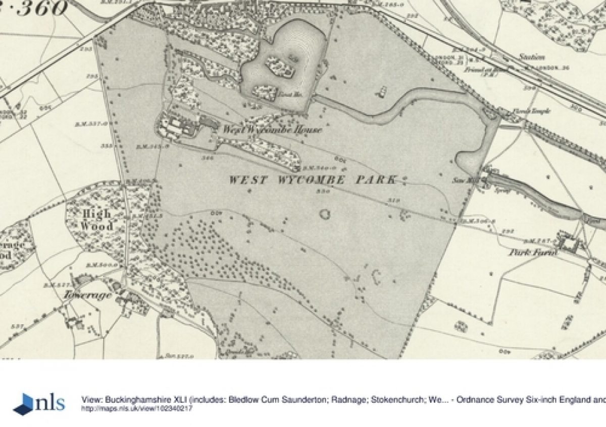
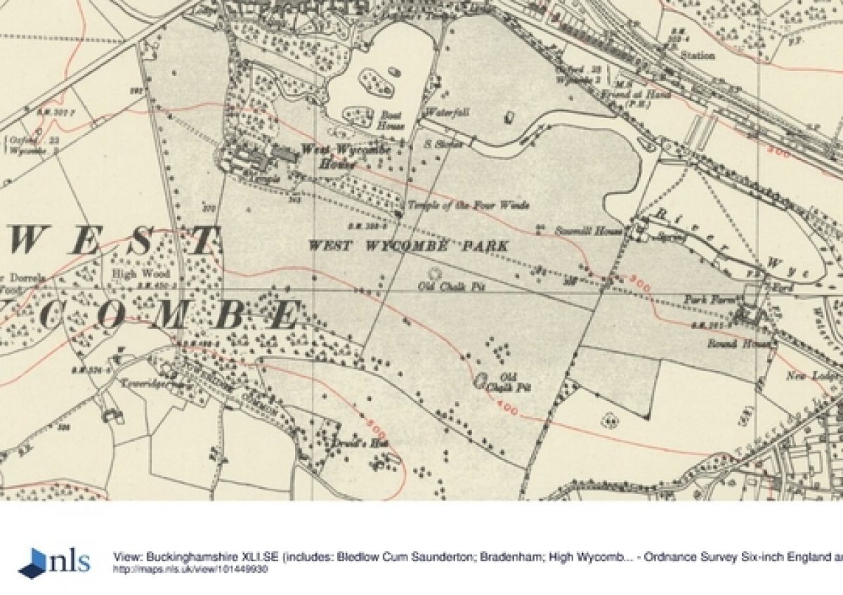
The c 135ha site lies 4km west of the centre of High Wycombe, where four Chiltern valleys meet. The majority of the park runs along the western, upper part of the Wye valley, although a second, smaller area sits north of West Wycombe village, high on West Wycombe Hill.
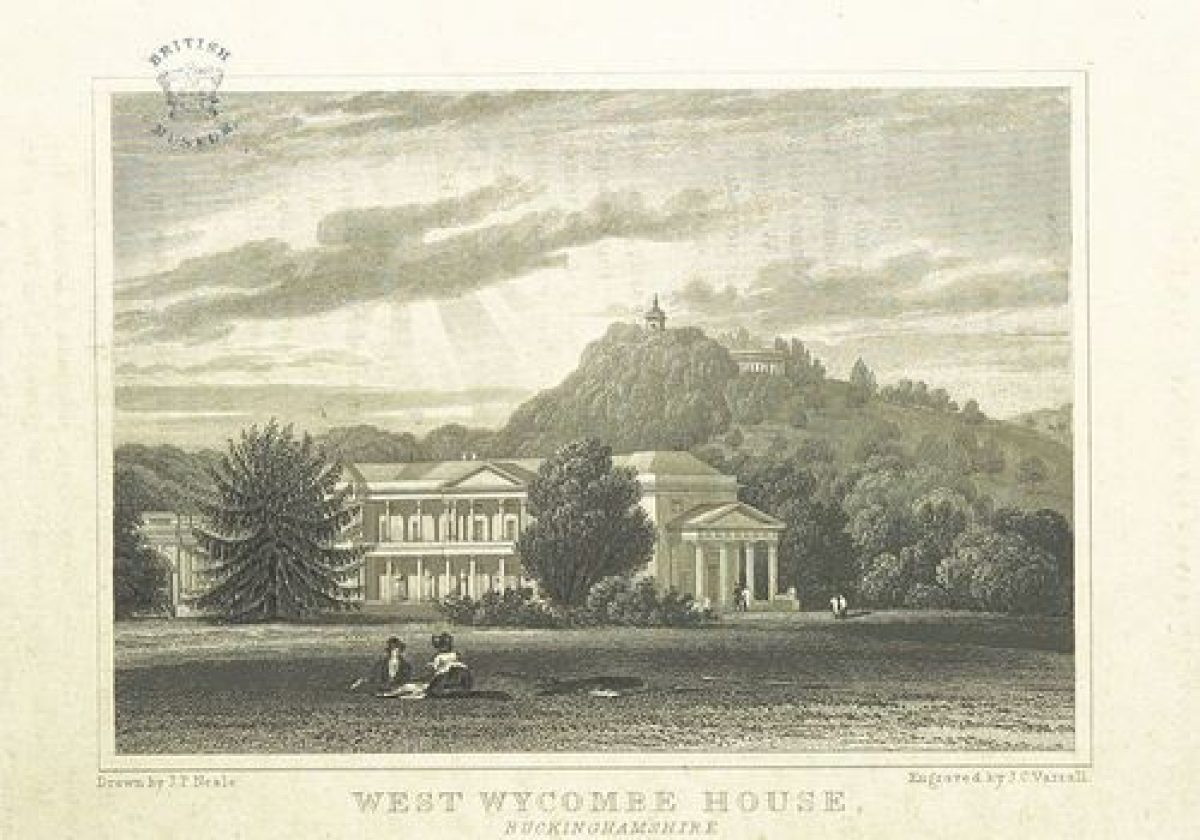
The site is bounded to the west by agricultural land and woodland, and to the east by the encroaching mid C20 urban sprawl of High Wycombe. The north boundary is formed by the picturesque old village of West Wycombe, and the A40 London to Oxford road which runs through it. The northern section of the site on either side of the River Wye is relatively flat with a slight fall to the east; the southern section rises up the rolling hillside to the south from the river valley. The setting to the west is still that of the pastoral and sylvan Chiltern Hills, encompassing the dominant mass of West Wycombe Hill, with its church and mausoleum, to the north.
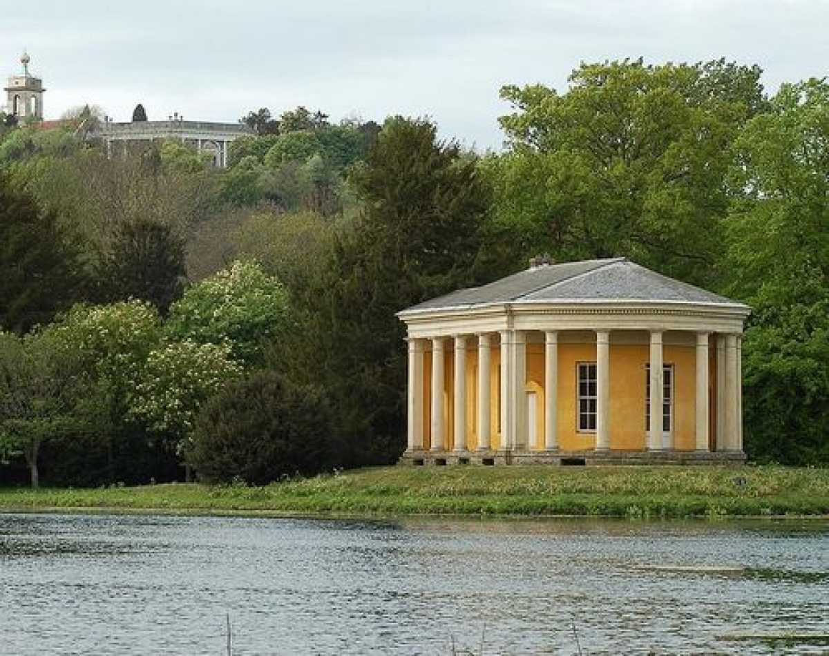
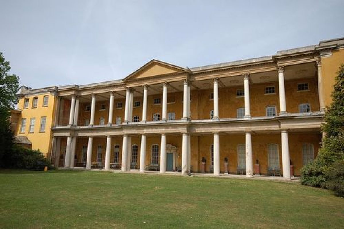
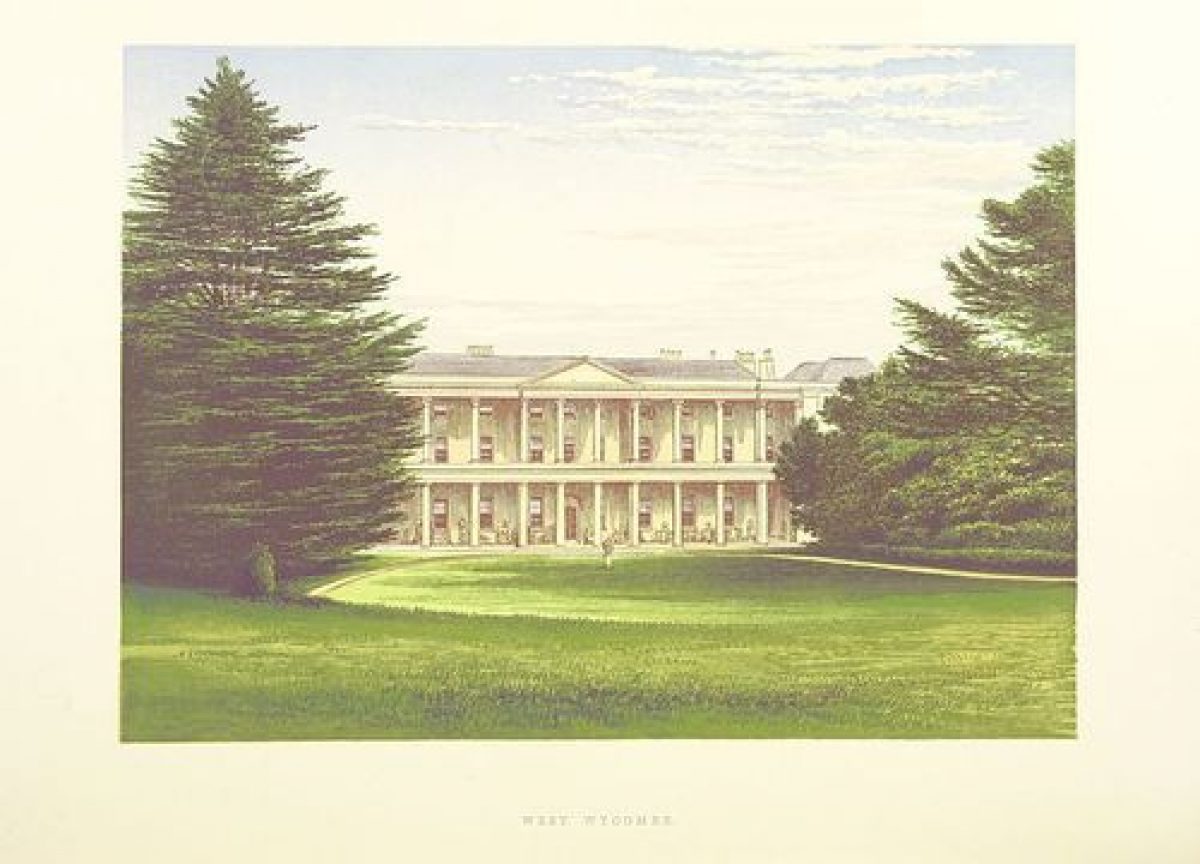
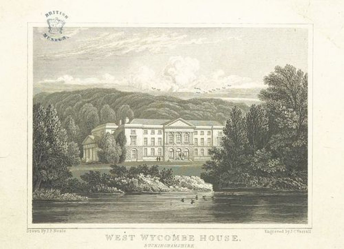
The site consists of pleasure grounds, park and woodland. The house (c 1710-15, enlarged mid C18, listed grade I) lies towards the west end of the site, at the south-west corner of the pleasure grounds, facing north and sitting above the pleasure grounds. The house also faces south, looking up the parkland to a wooded ridge. The inner pleasure grounds cover 18ha and are bounded to west, east and south by the outer park, and to the north by West Wycombe. The lake, created by damming the River Wye, is the dominant feature in the pleasure grounds. It is prominent in views north-east from the house, framed by two little flint bridges (C18, listed grade II). In these views a fragmentary view of the Music Temple (Nicholas Revett 1778-80, listed grade II*), on the central island of three, is visible. This building, one of the last to be constructed by Sir Francis, is pivotal in many views in both park and pleasure grounds and is the focus at the centre of the landscape.
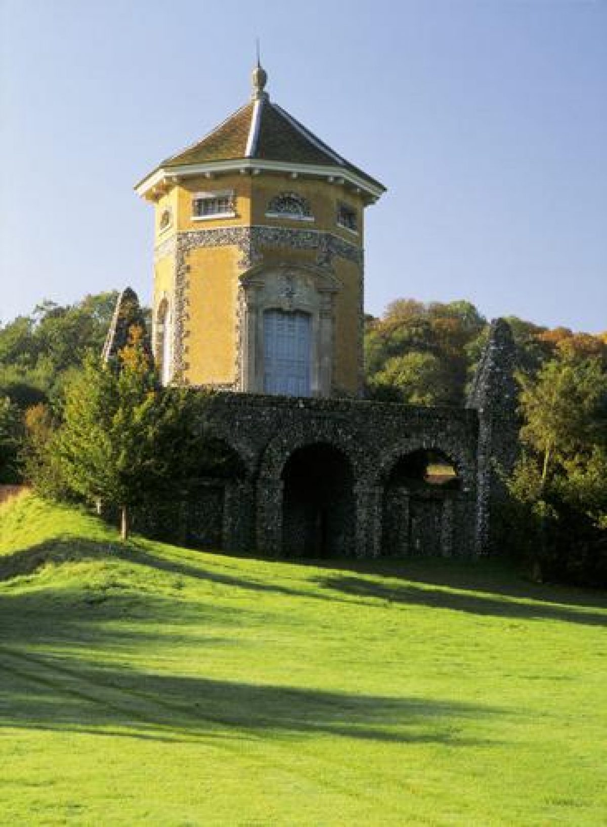
The pleasure grounds contain many ornamental buildings built by Sir Francis in the mid to late C18, linked by rides and paths through trees, and expanses of lawn. The west drive enters from the west end of the village, giving glimpses of several features as it progresses south to the porticoed west front of the house. The substantial areas of trees provide a setting for the buildings, as well as separating them, so that the visitor is continually surprised by unexpected features and vistas. The east drive bisects the park between the east end of the pleasure grounds and the east boundary, entering off the A4010 road to Marlow, and running almost straight across the park, along the south boundary of the pleasure grounds, terminating west of the house and service buildings. The Temple of the Four Winds (?Nicholas Revett 1759, listed grade II*) lies at the south-east corner of the pleasure grounds sited prominently on an artificial knoll, being both an observation point for the park to the east and south, and an eyecatcher from the east drive and the park. It is an octagonal tower based on an C18 engraving of the C2 Tower of the Four Winds in Athens.
The north-east park, east of the pleasure grounds, contains several scattered ornamental buildings and is of open character. The River Wye winds from the cascade in the west (C18, C20, listed grade II) to the Pepper Box Bridge (C18, listed grade II) at the east end of the park. The Wye has been deliberately widened out in places to increase its visual importance. The dominant building is Sawmill House (mid C18, listed grade II*) in the middle of the north-east park, straddling the river. Originally used as saw mills, a central flint-faced pavilion is linked by low, arcaded connecting links to two small, outer pavilions. The whole park is surrounded by wooded hilltops and has wide views all around. The church tower of St Lawrence (tower 1751, nave and chancel 1765, listed grade I), and the mausoleum (John Bastard the Younger 1765, listed grade I) on West Wycombe Hill are eyecatchers in views north and west towards and beyond the pleasure grounds. The Temple of the Four Winds, the Music Temple, the church and mausoleum, together with glimpses of the house are a significant composition from the north-east park and Sawmill House. The flint gothic facade of the cave (1750-2, listed grade II*) in West Wycombe Hill is also part of the landscape, visible from the park south of the house. The park south of the east drive is largely arable. It lies on a hillside sloping up southwards towards belts of woodland on the ridge which mark the park boundary.
REFERENCES
Note: There is a wealth of material about this site. Some key references are cited below.
Country Life, 39 (1 January 1916), pp 16-24; (8 January 1916), pp 48-55; 73 (6 May 1933), pp 466-71; 155 (20 June 1974), pp 1618-21; (27 June 1974), pp 1682-5
J Harris, The Artist and the Country House (1979), pp 200-1
Sir F Dashwood, The Dashwoods of West Wycombe (1987)
West Wycombe Park, guidebook, (National Trust 1989)
N Pevsner and E Williamson, The Buildings of England: Buckinghamshire (1994), pp 727-40
Maps
West Wycombe Manor, 1698 (copy at Buckinghamshire Record Office)
West Wycombe Park and Gardens, 1752 (copy at Buckinghamshire Record Office)
West Wycombe Manor, 1767 (copy at Buckinghamshire Record Office)
Tithe map for West Wycombe parish, 1849 (Buckinghamshire Record Office)
OS 6" to 1 mile:
1st edition published 1885
2nd edition published 1900
OS 25" to 1 mile: 2nd edition published 1898
Description written: 1997 Amended: April 1999
Register Inspector: SR
Edited: September 2000
- Visitor Access, Directions & Contacts
Telephone
0844 800 1895Access contact details
The grounds are open from April to August from 2 - 6 pm. It is closed on Fridays and Saturdays. https://www.nationaltrust.org.uk/place-pages/360/pages/opening-times-calendar
Directions
2 miles west of High Wycombe, on the south side of the Oxford road.
Owners
The National Trust
Heelis, Kemble Drive, Swindon, SN2 2NA
- History
The following is from the Register of Parks and Gardens of Special Historic Interest. For the most up-to-date Register entry, please visit the The National Heritage List for England (NHLE):
www.historicengland.org.uk/listing/the-list
HISTORIC DEVELOPMENT
The Dashwoods acquired the manor of West Wycombe in 1698. In 1705 Francis Dashwood settled at West Wycombe and was created a baronet in 1707. Replacing the C17 manor house near the village, Sir Francis built the core of the current house c 1710(15, 350m south of the village, on the far side of the Wye valley. He died in 1724, when his son, Sir Francis, the second Baronet, was sixteen. This Sir Francis embarked on a series of grand tours throughout Europe and Asia Minor between 1726 and 1741, which were to influence his development of the West Wycombe estate. He effected a complete transformation of the house and estate between 1735 and 1781 when he died, leaving it largely as it is today. 'Beginning with a scheme as formal as Bridgeman at Stowe, straight avenues and points de vue, and neatly mown lawns descending in even ramps to a straight-edged lake, he subtly softened the lines of the landscape, carefully introducing a note of natural wildness when the vogue for Brown's type of picturesque gardening was at its height, and finally towards the end of his life built to Revett's designs a series of neo-classical garden buildings whose archaeological inspiration was well before its time' (CL 1974).
The succeeding Dashwoods did not materially alter the house or the landscape except for necessary replanting and the restoration of some buildings. Humphry Repton (1752-1818) advised in the 1790s, and seems to have removed some garden buildings, together with large statues on the roof of Sawmill House and the spire from the mock church of St Crispin. He may also have removed several statues from Venus' Parlour. In 1943 the house and park were given to the National Trust, in whose ownership they remain (1997).
Period
18th Century (1701 to 1800)
- Associated People
- Features & Designations
Designations
The National Heritage List for England: Register of Parks and Gardens
- Reference: GD1415
- Grade: I
Features
- Temple
- Folly
- House (featured building)
- Description: The core of the current house was built between 1710 and 1715, and substantially transformed in the mid and late-18th century.
- Earliest Date:
- Latest Date:
- Key Information
Type
Park
Purpose
Ornamental
Principal Building
Domestic / Residential
Period
18th Century (1701 to 1800)
Survival
Extant
Hectares
135
Open to the public
Yes
Civil Parish
West Wycombe
- References
References
- {English Heritage Register of Parks and Gardens of Special Historic Interest} (Swindon: English Heritage 2008) [on CD-ROM] Historic England Register of Parks and Gardens of Special Historic Interest
- Harris, J {The Artist and the Country House} (London: Russell Chambers, 1979) 200-1 The Artist and the Country House
- Pevsner, N and Williamson, E {The Buildings of England: Buckinghamshire} (1994) pp 727-740 The Buildings of England: Buckinghamshire
- Wheeler, Richard {West Wycombe Garden Conservation Plan} (2005) West Wycombe Garden Conservation Plan
- Parklands Consortium (Fryer, Hazel; Rutherford, Sarah) {West Wycombe Hill: Historic Landscape Management Plan} (2009) West Wycombe Hill: Historic Landscape Management Plan
- Related Documents
- CLS 1/146/1
-
CLS 1/1041
Gardens of Stowe and est Wycombe: Paradise and Parody? - Hard Copy
Richard Wheeler - undated