Introduction
Wotton Underwood is a mid-18th-century park, landscape and woodland. At its most extensive the grounds covered about 800 hectares. The land is now in divided use.
Terrain
The surrounding land slopes gently down to the west into the park and east along the east avenue, and more sharply down along the south drive into the largely level village below.The following is from the Register of Parks and Gardens of Special Historic Interest. For the most up-to-date Register entry, please visit The National Heritage List for England (NHLE):
An early C18 country house surrounded by a C17 and early C18 garden, with an extensive mid C18 park probably by Lancelot Brown.
Location, Area, Boundaries, Landform and Setting
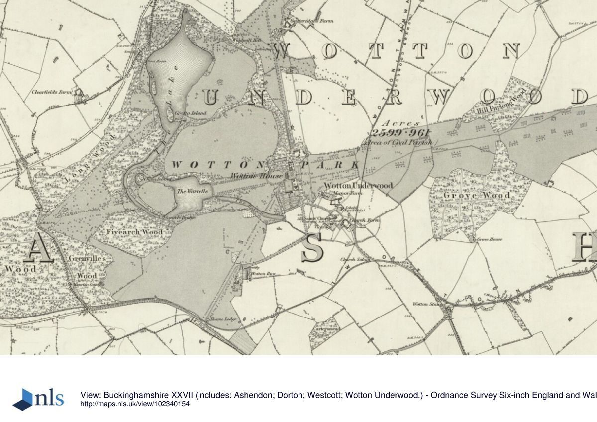
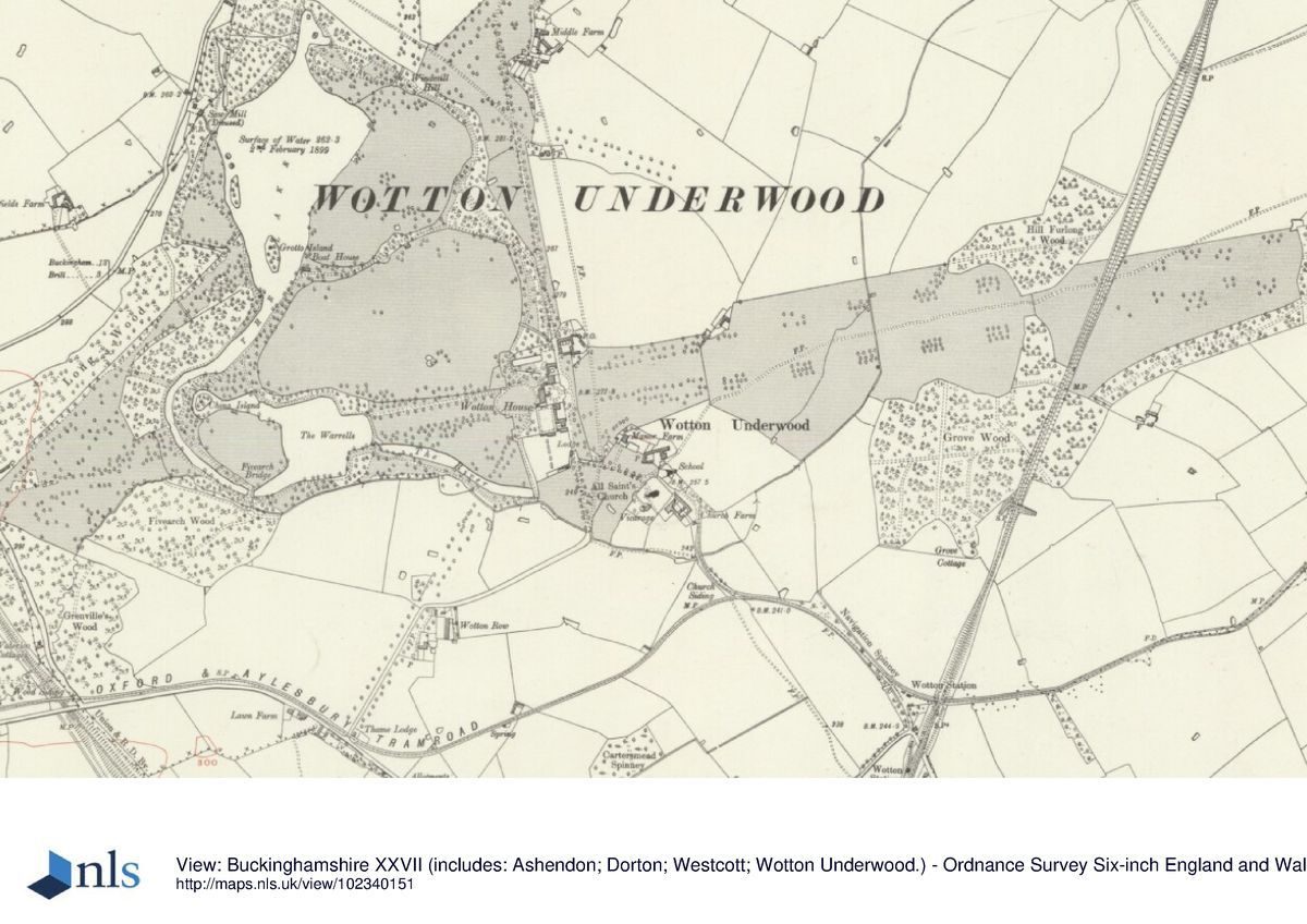
Wotton House lies at the north-west corner of Wotton Underwood village, in the Vale of Aylesbury, 10km north of Thame and 13km west of Aylesbury. The 190ha site is bounded largely by agricultural land, with the Ludgershall lane on the west boundary and the lane to Kingswood running north close to the north boundary. The House is prominently set on a small rise, at the south end of a spine of land which runs north as marked by the north avenue. The surrounding land slopes gently down to the west into the park and east along the east avenue, and more sharply down along the south drive into the largely level village below. The setting is largely agricultural and wooded, with the late C19 wooded landscape of Waddesdon Manor (qv) prominent on Lodge Hill 5km to the east, with surrounding hills, including Ashendon and Dorton Hills, visible in views to the south, and Wotton village lying 200-400m south-east of the House. Tittershall and Grove Woods, to the north and east respectively, seem to have been aligned with the landscape design.
Entrances and Approaches
The main approach is from the south, entering 1km south-west of the House, off the lane to Brill, past the two-storey rendered and white-painted Thame Lodge, along the lane to the village which runs straight initially, along the course of one of the C18 avenues (now gone, 1997) aligned on the south-west corner of the House. The lane turns sharply east, off the line of the avenue, arriving at the village green, through which it runs north along a 150m lime avenue, with a view of the church to the east. The lane becomes the drive where it passes between a pair of brick piers with stone ball finials, with a single-storey brick lodge, from here continuing up a short rise to arrive at the east side of the forecourt east of the House. The forecourt is bounded on the west by the House, to the north by the Clock Pavilion, and to the south by the South Pavilion, both pavilions being connected to the House by curving, ashlar quadrant wings with oval windows. The forecourt, laid out with a circular panel of lawn surrounded by a gravel turning circle, is closed by a wrought-iron screen, gates and overthrow supported by stone gate piers and walls (Thomas Robinson early C18, listed grade I). A small brick gazebo with stone quoins stands in the garden of the Clock Pavilion, attached to the north end of the screen wall.
The south drive continues north past the forecourt, a spur west leading between further stone piers, past the Clock Pavilion, into the gravelled north courtyard adjacent to the north front of the House. This court is bounded to the west by a C20 low brick wall with wrought-iron railings and gate (early C18, probably Thomas Robinson, listed grade II), moved from the west end of the fishpond 75m north of the House. The main drive continues in a straight line north, past Brewer's Yard north of the Clock Pavilion, along the brick boundary wall of the yard, arriving at a group of six piers 60m north of Brewer's Yard (listed grade II). The four inner, brick piers are of the early C18, rebuilt in the C20, with C20 cast-iron railings and gates; the two outer, ashlar piers are early C19. Adjacent to the east is a single-storey brick lodge in similar style to that on the south drive. The piers and lodge flank the southern end of the north avenue, largely replanted in the C20, which may have been planted initially by George London (Listed Building description). The north drive runs straight along the avenue, turning north-east 1km north of the House to lead straight to Middle Lodge and beyond to Ham Lodge on the A41. This drive is no longer in use.
Principal Building
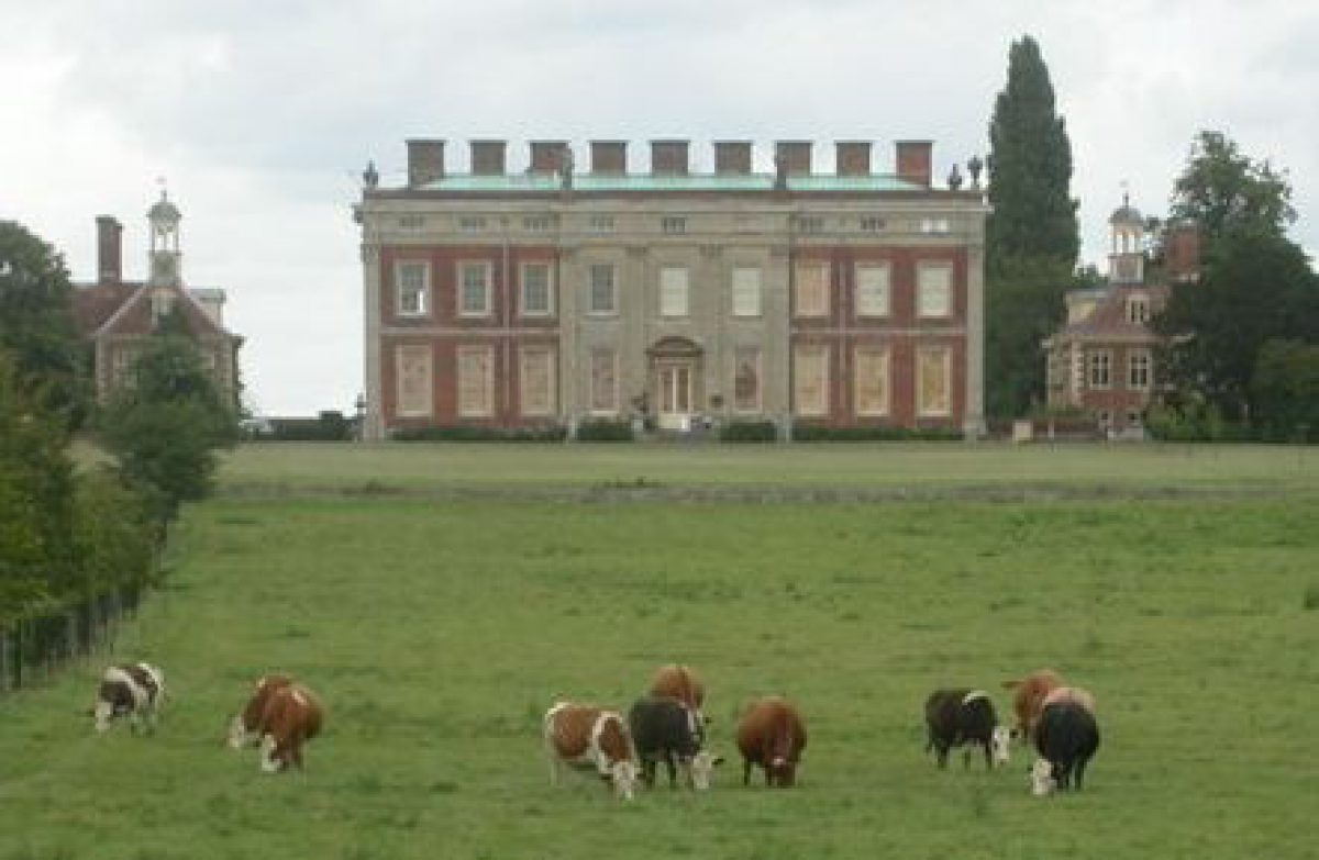
Wotton House (architect unknown, 1704-14, listed grade I) lies towards the southern edge of the park, a rectangular red-brick building with ashlar dressings, much rebuilt by Sir John Soane in the 1820s and joined by quadrant walls to two early C18 brick service wings also with ashlar dressings, now converted to houses. The two main fronts of the House have panoramic views to the west and east respectively, down into the park in both directions, the eye being drawn by broad straight avenues to west and east, aligned on the fronts, and beyond the park to the hills. The remains of the stable block lie 100m north-east of the House and have been converted to residential use.
Gardens and Pleasure Grounds
The gardens lie close to the House to the north, west and south. Adjacent to the west front, a large, open lawn is bounded 100m west of the House by a mid C18 brick, arcaded ha-ha, which has a central semicircular projection into the park and recessed flanking bays. The brick walls were covered in the late C19 by an ashlar wall, removed in places (late C20) to expose the earlier work. A rectangular pond (part of the early C18 scheme) lies 75m north of the House, surrounded by trees. South of the House, at a lower level, the rectangular, brick-walled garden (early C18, listed grade II) is said to be part of the garden designed by George London. It is reached from the House by an arcaded stone terrace and double staircase with wrought-iron balustrade, with an orangery set into the space under the west side of the terrace and a shell niche between the arms of the staircase (all early C18, listed grade I under Wotton House). A pavilion, restored c 1980, is set into the south wall of the garden, with Ionic stone piers at the front supporting the entrance arch, flanked by two further stone piers. The garden is largely laid to lawn with a gravel perimeter path and low, clipped hedges in a late C20 pattern.
The pleasure grounds lie west of the House, encompassing two roughly circular paddocks and a string of water features enclosed by ornamental woodland underplanted with flowering shrubs in places and fringed by parkland. This is the setting for walks and rides, with various buildings, features and views as incidents along their course, believed to have been designed by Lancelot Brown during the 1750s, following advice, given possibly in the 1730s, by William Pitt, first Earl of Chatham.
The large, irregularly shaped Lake lies at the north end of the pleasure grounds and contains several islands, the largest of which is Grotto Island towards the southern end, on which stands the Grotto (1750s, C19 alterations, listed grade II). This brick building, which in the C18 had a rendered facing to the front incorporating columns, and was rebuilt in the C19 with short curved flanking walls of brick faced with flint, is partly covered by an earth mound to the south. South of Grotto Island The Lake narrows to run south as a curving canal, crossed by a wooden Palladian bridge (late C20 reconstruction), to the stone-faced Five arch Bridge (1750s, listed grade II) at its southern end, which disguises a dam with an overflow from the canal. Below the bridge, on the east side, the dam has matching stone facing with blind arches flanking the central overflow arch. The water flows into The Warrells, a symmetrical lake naturalised (Brown, 1750s) at its west corners into narrow channels, with Five arch Bridge terminating the south-west corner and the north-west corner terminated by China Island. Two Tuscan Pavilions (1750s, repaired and partly rebuilt 1980s, listed grade II) stand one at each corner of the east end, each in the form of a small temple with a pedimented wooden portico at each end. They are set at a slight angle to the wide west avenue along the main axis of the House, so that the northernmost looks south-west towards Five arch Bridge and the southernmost looks north-west towards China Island, whilst standing above a small cascade down into The River to the east. The River, lying below The Warrells, terminates at the south-east corner of the pleasure grounds where the water is channelled into a small stream which runs out into farmland.
The main circuit walk leads north from the House along the east edge of the two paddocks, past the site of the old manor house, to the Turkey Building (1750s, restored late C20, listed grade II), a wooden garden pavilion in oriental style, open to the west, lying c 600m north of the House. From here both short and long views open to the west and south-west over the park and The Lake towards the distant Muswell Hill with its prominent clump of trees. The path curves north to Windmill Hill, a mound planted with a circle of mature yew trees which was the site of a windmill before the C18. It offers views along former avenues to the north and north-east (along the north drive), and south-east, and south-west across The Lake into woodland in the south-west corner of the park. The path runs west to The Rotunda, a pavilion in the form of a circular temple with ten columns and a shallow domed roof (1750s, restored late C20, listed grade II), which stands above the north edge of The Lake. From here there are views south across The Lake, and south-east back towards the Turkey Building. The path continues around the northern tip of The Lake, returning south along the western edge past the high-curved wooden bridge (late C20 reconstruction). From the bridge there is a view south towards the main front of the Grotto.
Continuing south along The Lake's western edge, past the wooden Rustic Summer House (mid(late C19, listed grade II), several mounds occur close to the path which may have had small ornamental features on them or may have been viewing points. South-west of Grotto Island stands the Octagon (rebuilt 1990s), an open, octagonal pavilion which has a gravel path running through it from north to south and a view through the tree belt on the south-east side of The Lake to the House. The path continues to curve south along the west bank of the canal, with a parallel path on the east bank linked by the Palladian Bridge and Five arch Bridge, and formerly by a boat kept in the boathouse (disappeared mid-late C20) on the east bank at the south end of The Lake. The walk on the east bank is also reached from a path to the north-east, which spurs off the main path east of the two large paddocks, giving more direct access from the House to the east bank of The Lake. The path runs through the narrow belt which divides the two main paddocks, associated views to north and south roughly marking the mid-way point. The paths flanking the canal join at Five arch Bridge, continuing east as one path along the south bank of The Warrells, reaching the southern Tuscan Pavilion, with a spur north to its northern companion. From here the path continues east along the south bank of The River, returning north along the top of the ha-ha and so back to the lawn below the west front of the House.
Park
Areas of parkland, largely pasture, fringe the garden and pleasure grounds. East of the House the east park extends eastwards for 1.3km; across this runs the site of the east avenue (west end replanted late C20), aligned on the east front, with a sunk fence running north/south c 100m east of the House. West of the House is the west avenue (replanted late C20), a double avenue running west from the ha-ha on the west lawn to The Warrells, and lying in an area of parkland planted with several ornamental specimen trees which links the House with the pleasure grounds. South-west of the pleasure grounds lies The Park, an area of parkland largely surrounded by woodland, visible in the view west from the upper storeys of the House. A long, narrow view east to the west front of the House occurs at the prominent curve in the road adjacent to the gap in the woodland at the west edge of The Park.
Kitchen Garden
The kitchen garden lies south of the walled garden on the south front of the House, surrounded by red-brick walls and laid to lawn. Its north wall is shared with the walled garden and incorporates the rear of the restored early C18 alcove.
Maps
- Wotton Underwood area, pre 1600 (Buckinghamshire Record Office)
- Manor of Wotton Underwood, belonging to Richard Grenville esq, 1649 (Buckinghamshire Record Office)
- The Manor (belonging to R Grenville), nd (c 1649), (Buckinghamshire Record Office)
- Part of the Wotton Estate ... the property of the Marquis of Chandos, c 1840 (Buckinghamshire Record Office)
- Plan of Wotton House and grounds, 1890 (Buckinghamshire Record Office)
- OS 6" to 1 mile:
- 1st edition published 1885
- 2nd edition published 1900
- 3rd edition published
- 1923 OS 25" to 1 mile:
- 1st edition published 1881-2
- 2nd edition published 1899
Description written: 1997 Amended: April 1999
Register Inspector: SR
Edited: September 2000
- Visitor Access, Directions & Contacts
Directions
South-east of Bicester, south of the A41.
- History
The following is from the Register of Parks and Gardens of Special Historic Interest. For the most up-to-date Register entry, please visit The National Heritage List for England (NHLE):
12th Century
Although Wotton Underwood manor house is not mentioned until 1618, the Grenville family owned land at Wotton from the C12 throughout the Middle Ages, as knights and sheriffs of the county.
17th Century
A series of radial avenues was laid out by 1649 (Manor of Wotton Underwood ..., 1649).
18th - 19th Century
Between 1704 and 1714 Richard Grenville, the sixth in a succession of fathers and sons of this name, built a house on a new site, possibly c 300m south of the earlier manor house. The House was surrounded by formal garden enclosures, and Grenville seems to have laid out a landscape, possibly with the help of George London (d 1714) (Pevsner and Williamson 1994; Listed Building descriptions), incorporating the C17 avenues. Grenville's son, also Richard (d 1727), consolidated the family fortunes c 1700 by marrying Hester Temple, the sister and heir of Viscount Cobham of Stowe (d 1749), introducing to Wotton the influence of Cobham's gardening activities at Stowe (qv). It seems that William Pitt the Elder, first Earl of Chatham (1708-78) claimed to have helped plan 'the enchanting two miles of water scenery still to be seen' (Garden Hist 1996), possibly in the 1730s (J Phibbs pers comm, 1998).
Lancelot Brown (1716-83) worked at Wotton briefly in 1739-40, at the beginning of his career, before moving to Stowe. Following Lord Cobham's death in 1749 his sister Hester inherited his estates, and Stowe became the main residence of the Grenville family who then used Wotton as a subsidiary residence. It is believed that Brown returned to Wotton over a number of years in the 1750s, during which time he landscaped the park (D Gladstone pers comm, 1997). The village of sixty-five or more houses, largely lying along the line of the north avenue, was probably removed during the landscaping works in the 1750s. It is shown on a map of 1649 extending north from the church for c 1km through the site of the present house.
The landscape remained largely undisturbed after the mid C18 except for some work undertaken in the park in the C19, including the addition of the Rustic Summer House and the islands in The Lake.
20th -21st Century
The estate was sold by the Grenvilles c 1920, at the same time as Stowe was sold, subsequently having several owners in succession, during which time nearly all of the standing timber was felled.
The estate is currently (2023) in divided ownership, the House remaining a private residence.
- Associated People
- Features & Designations
Designations
The National Heritage List for England: Register of Parks and Gardens
- Reference: GD1598
- Grade: II*
Features
- House (featured building)
- Description: The house is prominently set on a small rise, at the south end of a spine of land which runs north as marked by the north avenue.
- Earliest Date:
- Latest Date:
- Key Information
Type
Park
Purpose
Ornamental
Principal Building
Domestic / Residential
Survival
Part: ground/below ground level remains
Hectares
190
Open to the public
Yes
Civil Parish
Wotton Underwood
- References
References
- {English Heritage Register of Parks and Gardens of Special Historic Interest} (Swindon: Englsih Heritage 2008) [on CD-ROM] Historic England Register of Parks and Gardens of Special Historic Interest
- Harris, J {The Artist and the Country House} (London: Russell Chambers, 1979) 259 The Artist and the Country House
- Pevsner, N and Williamson, E {The Buildings of England: Buckinghamshire} (1994) 764-767 The Buildings of England: Buckinghamshire
- (23 January 1904), pp 126-35; 106 (1 July 1949), pp 38-41; (8 July 1949), pp 110-13; (15 July 1949), pp 182-5 Country Life, 15
- no 1 (Summer 1996), p 134 Garden History, 24