Introduction
Trelissick is a mid-18th-century park and early- and late-19th-century pleasure grounds, woodland and agricultural landscape of 92 hectares.
Terrain
The site occupies a shoulder of high ground from which the land drops steeply to the water to the north, east, and south.The following is from the Register of Parks and Gardens of Special Historic Interest. For the most up-to-date Register entry, please visit the The National Heritage List for England (NHLE):
A mid 18th century park and early and late 19th century pleasure grounds, together with a mid and late 20th century woodland garden.
Location, Area, Boundaries, Landform and Setting
Trelissick is situated c 4.5km south of Truro, to the west of the River Fal and to the north of Carrick Roads. The c 92ha site comprises some 10ha of gardens and pleasure grounds, and c 82ha of parkland and woodland rides. To the north the site is bounded by Lamouth Creek, while to the north-east, east, and south it adjoins the River Fal. To the south-west lies Channals Creek, the head of which is dammed to form a lake, while to the west the site adjoins agricultural land. The B3289 road runs from west to east through the site to reach King Harry Ferry c 300m east of the house. The site occupies a shoulder of high ground from which the land drops steeply to the water to the north, east, and south.
There are extensive views south and south-west down the River Fal to Carrick Roads and Pendennis Castle, while to the east there are views across the River Fal to the wooded west-facing slopes on the opposite shore. To the north-east there is a vista up the River Fal to Tregothnan (qv). To the south-west Pill Farm (outside the site here registered) forms a backdrop to the important coastal and river views from the park.
Entrances and Approaches
Trelissick is approached from the B3289 road at a point approximately opposite Trelissick Cottages, c 370m north-west of the house. A late C20 visitors' entrance leads to a drive which sweeps south and south-east through an area of lawns and scattered trees to reach a car park c 100m north-east of the stables and Home Farm buildings which today (2000) provide visitor facilities and an entrance to the gardens.
The approach to the mansion is also from the B3289 road at a point c 800m north-west of the house. New Lodge (listed grade II), a mid C19 two-storey, Gothic-style stone structure stands to the north-east of the entrance which is marked by a pair of square-section granite piers surmounted by caps with sloping sides and flat square bases which may formerly have supported statues. To the north-east the Lodge adjoins a stone wall with granite copings which extends east along the B3289 road.
Beyond the entrance the tarmac drive sweeps south-east and east through the park. Some 240m south-east of the entrance a drive leads south-west from the main drive to reach Lis Escop, a house built c 1965 to serve as an episcopal palace; the house is set in pleasure grounds comprising lawns, shrubberies, and specimen trees. The main drive continues c 500m east-south-east through the park, revealing a series of views south and south-west towards Carrick Roads, to reach a pair of low lattice-pattern, wrought-iron gates supported on granite piers with pyramid caps which lead to the carriage court below the west façade of the house. The carriage court is separated from the park to the west by a low stone wall. Some 640m north-west of the house and adjacent to the B3289 road stands Old Lodge (listed grade II), a single-storey stuccoed building with a classical pediment to the west supported by Doric columns. The Lodge was built c 1825, perhaps to the design of P F Robinson.
The west drive was initially laid out for Thomas Daniell c 1825 when the public road to the north of the house (today the B3289 road) was diverted to its present course and Old Lodge was constructed; this arrangement is shown on the Tithe map of 1842. Archaeological traces of the former road survive in the park adjacent to the late C20 metal fence which marks the southern boundary of the car park. Following the sale of the estate to John Davies Gilbert in 1844 the course of the west drive was altered and extended further west, and New Lodge and the present entrance were built. This new arrangement was established before 1878 when it was shown on the 25" OS map.
A service drive approaches the stables and Home Farm from the B3289 road at a point c 130m north-north-west of the house. The stables and carriage house (listed grade II) are U-shaped on plan and are constructed in brick under hipped slate roofs; they were built in the mid C19. Two early or mid C19 rubble-stone barns (both listed grade II) stand c 80m north-west of the house; these have been converted to serve as visitor facilities.
Principal Building
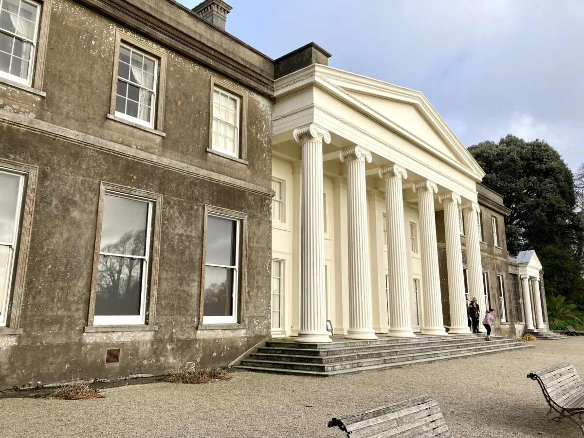
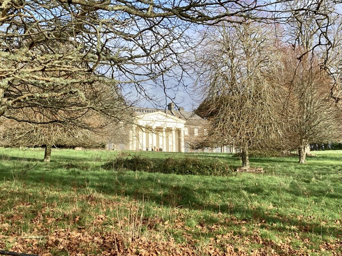
Trelissick (listed grade II*) stands on a level terrace above a south-facing slope which falls away to the River Fal. The house is constructed in stucco over rubble and brick under hipped slate roofs, and comprises two storeys lit by sash windows, with attic dormers on the west façade. The entrance or west façade has an off-centre, single-storey Doric portico, while the symmetrical south façade, which overlooks the park, has a central Ionic portico, approached by a flight of stone steps, which rises to the full height of the building. At the east end of the south façade is a single-storey solarium constructed in stone with tall windows, a glazed roof, and a centrally placed Ionic portico. Service ranges extend to the north of the principal block.
The present mansion contains the core of a mid C18 house built for John Lawrence by Edmund Davey. By c 1820 this building comprised a central block with a ground-floor classical loggia, flanked to east and west by single-storey wings; this building is illustrated on the estate plan of c 1821. In 1825 P F Robinson remodelled the existing house, adding the present south and west porticos and a classically inspired parapet concealing flat roofs; this house was engraved by Thomas Allom in 1831. The building assumed its present form in the late C19 when Piers St Aubyn added a second storey to the east and west wings for Carew Davies Gilbert. The solarium to the east of the house was constructed by L D Cunliffe in 1933 to replace an earlier timber conservatory.
Gardens and Pleasure Grounds
The informal gardens and pleasure grounds are situated principally to the east and south-east of the house, with a formal terrace to the south separating the house from the park.
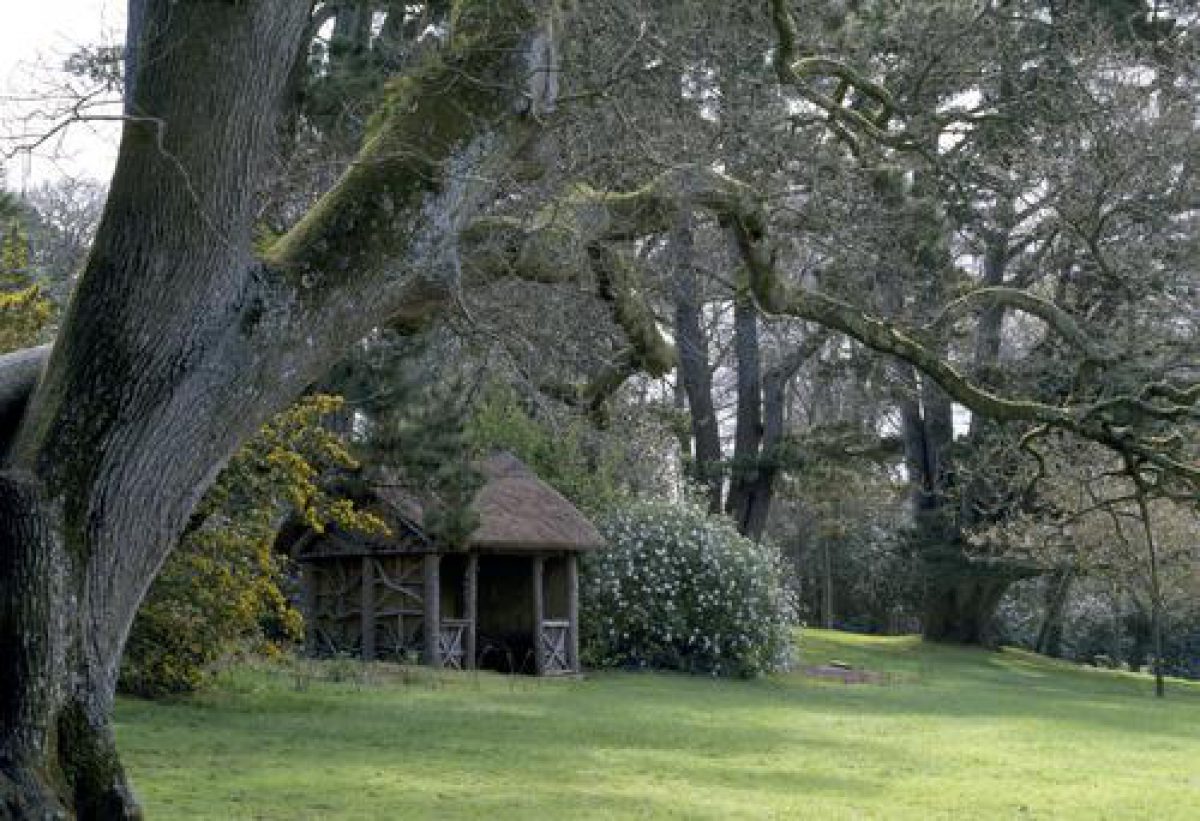
The terrace below the south façade of the house is gravelled, and is retained to the south by a low stone wall with granite copings which returns to east and west. A wide gravel walk leads west to an area of lawns and evergreen shrubbery which adjoins the carriage court, while a similar walk leads east to the pleasure grounds. Passing through a pair of low wrought-iron gates, this walk, known as the 'Shaded Walk', leads c 80m south-east through an area of mature trees underplanted with ornamental shrubs to reach a late C20 tunnel arbour which leads to a late C19 rustic timber summerhouse overlooking a tennis lawn. The lawn is retained to the west by a late C20 ha-ha which replaces late C19 metal estate fencing (guidebook), allowing wide views across the park to Carrick Roads and to the house. To the north, east, and south-east the lawn is enclosed by ornamental shrubbery. The tennis lawn was initially created as a croquet lawn by George Cookson who leased Trelissick in 1899.
From the tennis lawn an informal path descends south-east to reach further walks in South Wood. Two parallel terraced walks extend c 500m south through mature mixed woodland underplanted with an extensive collection of ornamental shrubs on the east-facing slope above the River Fal; a third parallel walk or ride passes through woodland between the boundary of the garden and the river. Some 560m south-east of the house the upper walk reaches an hexagonal rustic timber and thatch summerhouse. Constructed in 1996 to the design of Paul Edwards, the summerhouse stands on a rocky outcrop and affords views east across the River Fal to Penperth. Stone steps descend the rocks adjacent and to the north of the summerhouse to reach the lower walk which returns north to reach the pleasure grounds east of the house.
A broad gravel walk extends east from the late C20 visitors' entrance c 50m north of the house, and passes to the south of a lawn which occupies the north-facing slope to the east of the kitchen garden. The lawn is planted with mature specimen conifers and groups of ornamental trees and shrubs, while the south and east walls of the kitchen garden are screened by deep beds planted with ornamental shrubs and herbaceous plants. Similar planting encloses the lawn to the north, returning to the east to merge with the ornamental trees, shrubs, and water-loving plants in The Dell c 200m north-east of the house. The lawn was developed in the mid and late C19 on the site of an orchard which is shown on the estate survey of c 1821.
The Dell comprises a valley and north-facing slope bounded to the north by the B3289 road which extends east to the garden boundary; it is planted with a collection of large-leaved rhododendrons and tree ferns, together with hybrid daffodils raised by William Copeland, brother of Ronald Copeland, which are named after members of the latter's family (ibid). The principal gravel walk, known as the Hydrangea Walk, continues east of the lawn to reach a further north-east-facing glade, from which there is a view north-east towards Tregothnan (qv). To the south the walk is bordered by mature trees underplanted with a collection of rhododendrons and camellias, through which pass a series of curvilinear paths.
Some 80m north-east of the house a walk leads north, passing to the east of the lawn and to the west of The Dell, to reach a late C20 rustic timber footbridge which is carried on early C20 brick abutments across the B3289 road to reach a further area of pleasure grounds situated on a south-facing slope to the north of the road. This area, known as Carcaddon, was developed as pleasure grounds c 1960, and comprises lawns divided by specimen trees and conifers, and groups of ornamental shrubs including rhododendrons, camellias, magnolias, and hydrangeas underplanted with spring bulbs. A thatched rustic timber summerhouse stands towards the top of the slope c 250m north-east of the house. The footbridge leading to Carcaddon originally led from the pleasure grounds to the extensive network of woodland walks and rides which follow the shore of the River Fal and Lamouth Creek to the north of the B3289 road.
A further area of detached pleasure grounds is situated in the valley north-west of Channals Creek c 380m south-west of the house. A series of walks passes through mature woodland which adjoins an approximately triangular-shaped lake which was formed in the mid C19 by damming the head of the creek. On the west bank of the lake, c 560m south-west of the house, stand the ruins of a C19 cottage, while to the north of the lake a small cascade is ornamented with quartz boulders (LUC 1993). The woodland includes exotic moisture-loving plants and Chusan palms. In the late C19 and early C20 the lake was noted for its waterlilies, including many rare varieties (Gardeners' Chronicle 1894). A walk continues south from the lake, passing through coastal woodland with views north-east to Trelissick park and south-east across the River Fal to Turnaware Point. The lake and its associated pleasure grounds, and the coastal walks and woodland were developed in the mid and late C19 by John Davies Gilbert and Carew Davies Gilbert.
Park
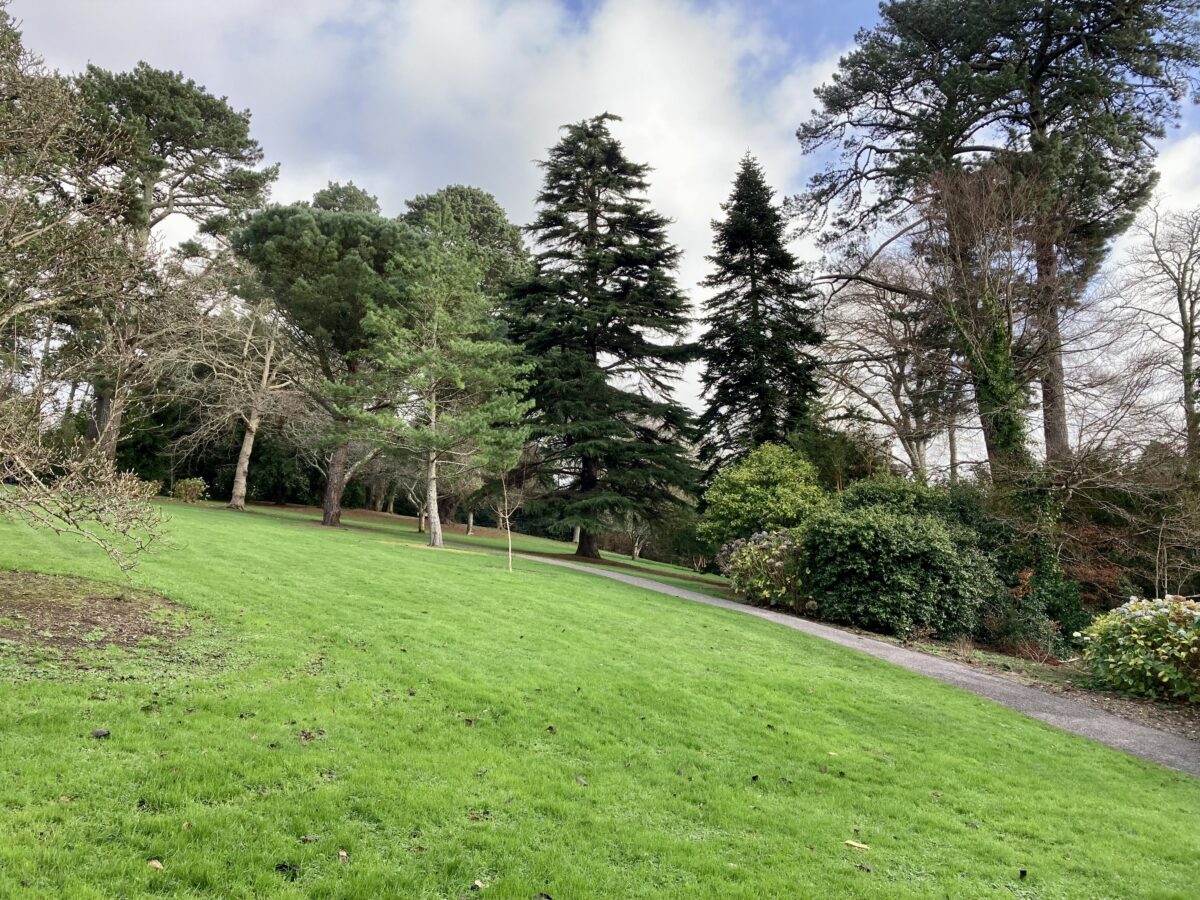
The park is situated principally to the south, west, and north-west of the house, with further coastal woodland walks and rides to the east and north. To the south and west of the house the park comprises undulating pasture with scattered specimen trees and small plantations which drops gently south towards the River Fal and Channals Creek. To the west the park adjoins the pleasure grounds associated with the lake north of Channals Creek, while there are further boundary plantations to the west and north-west. To the east the park is bounded by South Wood and the pleasure grounds south-east of the house. A walk or ride c 600m south of the house leads east round the headland east of Channals Creek, before entering woodland on the west bank of the River Fal.
Continuing c 750m north, the walk today (2000) crosses the B3289 road at a point c 100m west of King Harry Ferry. This mid C20 walk outside the garden boundary replaces the lower terrace walk which was taken into the pleasure grounds in the late C19. To the north of the public road the walk or ride continues parallel to the River Fal, passing through North Wood and sweeping west along the southern shore of Lamouth Creek through the early C19 Stiches Plantation and Namphillows Wood. A walk ascends south through Namphillows Wood to cross the B3289 road adjacent to Old Lodge, while further walks continue west and south-west through the mid C19 Delabole Wood. Stiches Plantation and Namphillows Wood form the east and west boundaries to a further area of park which is situated on a north-facing slope c 450m north-west of the house.
The park to the south and west of the house was initially created in the mid C18 to complement the new house built by John Lawrence in 1750. A park is marked on a survey of 1817, while by 1813 the 1" OS map shows North and South Wood to be established. The network of walks, rides, and carriage drives through the park and associated woodlands are shown on the estate survey of c 1821, indicating that Ralph Allen Daniell was responsible for laying out the park in its present form. The extension of the rides to the north-west through Namphillows Wood and the creation of Delabole Wood and the north-west park took place in the mid and late C19 after the estate was purchased by John Davies Gilbert.
Kitchen Garden
The kitchen garden is situated on a gentle east-facing slope c 50m north of the house, immediately to the east of the former Home Farm and stables. Irregularly shaped on plan, the garden is enclosed by brick walls c 3m high (listed grade II), and is today (2000) largely laid to grass with a section to the west separated by timber fences to form a plant sales area. To the north of the garden, and separated from it by a brick wall, is a rectangular yard enclosed by brick walls which contains bothies, sheds, and store rooms.
To the south-west of the garden and outside its walls, an approximately triangular-shaped area is enclosed to the south-west by low brick walls. Known as the Cutting Garden or Parsley Garden, this area is today adjacent to the visitors' entrance to the garden and has a partially ornamental treatment; in the C19 it was used for the cultivation of early vegetables and herbs (guidebook). Opposite the Parsley Garden a north-east-facing triangular-shaped lawn is planted with late C20 specimen figs; these replaced C19 specimens killed in 1979 (ibid). The kitchen garden, Parsley Garden, and Fig Garden are shown in their present form on the estate survey of c 1821.
Some 20m north-west of the kitchen garden and attached to the stone wall separating the service yard from the B3289 road is the Water Tower (listed grade II), a three-storey stone tower with a conical slate roof. This Gothic-style structure was erected as a water tower in the early C19 by Ralph Allen Daniell or his son Thomas; in the mid C19 it was converted into an apple store, and is today (2000) in domestic use.
To the north of the B3289 road and c 190m north-west of the house, a south-facing meadow has been planted in the late C20 as an orchard using a collection of Cornish apple varieties underplanted with Cornish varieties of daffodil (ibid).
References
Royal Cornwall Gazette, May 1802
C S Gilbert, Historical Survey of Cornwall ii, (1820), pp 807-808
P F Robinson, Designs for Ornamental Villas (1827), design no 3
R Ackerman, The Repository of Arts ... 9, (1827), pl 8
T Allom, Cornwall Illustrated ... (1831), pp 60-66
J Britton and E W Brayley, Devonshire and Cornwall Illustrated (1832), p 42
Lake's Parochial History of Cornwall ii, (1868), pp 6-7
Gardeners' Chronicle, ii (1894), p 500; i (1895), pp 70, 77; i (1896), p 485; i (1901), pp 342-343
Country Life, 131 (11 January 1962), pp 54-55
N Pevsner and E Radcliffe, The Buildings of England: Cornwall (2nd edn 1970), p 225
The Cornish Garden, 31 (March 1988) pp 24-29
Trelissick Park Restoration Plan, (Land Use Consultants 1993)
Trelissick Garden, guidebook, (National Trust 1997)
D E Pett, The Parks and Gardens of Cornwall (1998), pp 101-102
Maps
- Whittle and Laurie, Survey of Cornwall, 1817 (Cornwall Record Office)
- A Plan of the Manors, Estates and Premises in the Parishes of Feok, Kea and St Just ... belonging to R A Daniell, Esqr of Trelissick, about 1821 (Cornwall Record Office)
- Tithe map for Feok parish, 1842 (Cornwall Record Office)
- OS Old Series 1" to 1 mile, published 1813
- OS 25" to 1 mile: 1st edition surveyed 1878-1879, published 1880
- 2nd edition published 1906
Illustrations
- H W Carter, The River Fal from Trelissick Lawn, watercolour view, 1866 (Royal Institution of Cornwall)
Archival items
- The Davies Gilbert family papers are held in the Cornwall Record Office (DD/DG, GB, GHW)
Description written: December 2000
Amended: July 2001
Edited: October 2001
- Visitor Access, Directions & Contacts
Telephone
01872 862090Access contact details
The woodland and gardens are open daily, except Christmas and New Year. Core hours 11am to 4pm. https://www.nationaltrust.org.uk/place-pages/336/pages/opening-times-calendar
Directions
The gardens are 4 miles south of Truro on the B3289.
Owners
The National Trust
Heelis, Kemble Drive, Swindon, SN2 2NA
- History
The following is from the Register of Parks and Gardens of Special Historic Interest. For the most up-to-date Register entry, please visit The National Heritage List for England (NHLE):
13th Century
Trelissick appears to have existed as a farm by the late 13th century.
18th - 19th Century
In 1705 this was occupied by the Lawrence family, who had probably been established there since the mid or late 17th century. Edward Lawrence leased part of the manor of Trevilla including Trelissick in 1747 from John Willyams, and was succeeded by his son, John, in 1750. Soon after inheriting, John Lawrence built a mansion at Trelissick to the design of Edmund Davey and laid out a small park. When Lawrence died in 1790, the estate was divided, the larger portion being held by his widow. Trelissick was let to Francis Pender, while another portion of the estate, including King Harry Quay, was let to Ralph Allen Daniell. In 1802 Trelissick was described in the Royal Cornwall Gazette as standing 'much elevated', with grounds including a 'large walled garden well cloathed with fruit trees, a good orchard behind the house and a handsome lawn in front'.
The Lawrence family experienced financial difficulties after 1790, and in 1805 Trelissick was offered for sale as the result of legal action by the family's creditors, including Ralph Allen Daniell. Daniell, who now acquired Trelissick, was the son of a wealthy tin and copper mine owner, Thomas 'Guinea-a-Minute' Daniell and his wife, the niece and heiress of Ralph Allen of Prior Park, Bath. R A Daniell expanded and developed the 18th century park, creating rides through woodland to the north and south of the house; these developments are shown on an estate plan of about 1821, which also includes a vignette view of the house and park from the south.
When Daniell died in 1823 the estate passed to his son Thomas, who in 1825 commissioned the architect P F Robinson to enlarge and remodel the existing house. Robinson's design was published as an example of a 'Residence in the Grecian Style' in his Designs for Ornamental Villas (1827). In the same year it was noted that 'the plantations and shrubberies round the mansion are extremely beautiful, especially the latter, which abound with many varieties of choice shrubs' (Ackerman 1827).
Agricultural and mining depressions in the early 19th century left Thomas Daniell's fortune depleted, and in 1831 he was declared bankrupt. Trelissick came into the hands of Viscount Falmouth of Tregothnan who held a mortgage over it; the house remained unoccupied from 1832 to 1844, and Lord Falmouth tried, unsuccessfully, to sell the property in 1837 and 1839. Finally, in 1844, he sold it to John Davies Gilbert (1811-1854) who had inherited the manor of Eastbourne in Sussex, which he began to develop as a fashionable resort.
Gilbert restored the neglected house and pleasure grounds, but at his death in 1854 his son and heir, Carew Davies Gilbert, was still a minor. After coming of age, Carew Gilbert commissioned Piers St Aubyn to make additions to the house, and developed an extensive collection of conifers and other plants in the pleasure grounds; many of these were derived from his extensive foreign travels in the late 19th century. The estate was let in 1899 to George Cookson who further developed the gardens and pleasure grounds, these being described in Gardeners' Chronicle in 1894, 1895, and 1901.
20th - 21st Century
When Carew Davies died in 1913 the estate was divided, and the house and gardens were let to Leonard Daneham Cunliffe, a former Governor of the Bank of England. Cunliffe purchased the freehold interest in 1928, and at his death in 1937 this passed to his step-daughter, Mrs Ida Copeland and her husband. Until 1948 Mr and Mrs Copeland lived in Staffordshire where Mr Copeland was managing director of the china company W T Copeland and Sons Ltd; many of the flowers painted on their Spode china were grown at Trelissick. Already in the 1930s the Copelands had begun to develop the gardens north and east of the house, introducing a collection of rhododendrons obtained from Lord Aberconway's garden at Bodnant, north Wales, and from George Johnstone of Trewithen, Cornwall.
In 1955 Mrs Copeland gave 376 acres (about 156 hectares) of garden, park, and woodland to the National Trust while the mansion remained the family home and passed to Mrs Copeland's son at her death in 1964. The National Trust has continued the development of the gardens in the second half of the 20th century, and today (2000) the site remains in divided ownership.
- Associated People
- Features & Designations
Designations
The National Heritage List for England: Register of Parks and Gardens
- Reference: GD1647
- Grade: II*
Features
- River
- Description: To the north-east, east, and south the site adjoins the River Fal.
- Lake
- Mansion House (featured building)
- Description: The house was re-modelled in 1825. Additions were also made after 1854.
- Earliest Date:
- Parkland
- Pleasure Garden
- Woodland
- Key Information
Type
Estate
Purpose
Ornamental
Principal Building
Domestic / Residential
Survival
Extant
Hectares
92
Open to the public
Yes
Civil Parish
Feock
- References
References
- {English Heritage Register of Parks and Gardens of Special Historic Interest} (Swindon: English Heritage 2008) [on CD-ROM] Historic England Register of Parks and Gardens of Special Historic Interest
- Pevsner, N and Radcliffe, E {The Buildings of England: Cornwall} (Harmondsworth: Penguin, 1970) p 225 The Buildings of England: Cornwall
- Pett, D E {The Parks and Gardens of Cornwall} (1998) pp 101-102 The Parks and Gardens of Cornwall
- Related Documents
-
CLS 1/349
Restoration Plan - Digital copy
LUC - 1993
-
CLS 1/349