Introduction
Tregothnan is a landscape park developed in the early-19th century, with formal and woodland gardens of around 25 hectares. These are set within a larger woodland and agricultural estate. The garden is NOT open to the public, but private tours can be arranged. Please see: http://www.tregothnan.co.uk/the-botanic-garden/p_185/
Terrain
Tregothnan House stands on a spur of high ground, the land falling away to the Truro River to the west and the River Fal to the south; the parkland to the south of the house is undulating, with small, deep valleys falling south-west and south-east.The following is from the Register of Parks and Gardens of Special Historic Interest. For the most up-to-date Register entry, please visit the The National Heritage List for England (NHLE):
www.historicengland.org.uk/listing/the-list
Early 19th century gardens and pleasure grounds for which Humphry Repton produced a Red Book in 1809, with mid 19th century features by W A Nesfield, set in a wider 19th century landscape which incorporates a 17th century deer park.
DESCRIPTION
Location, Area, Boundaries, Landform and Setting
Tregothnan is situated c 0.5km south of the village of St Michael Penkevil, and c 4km south-east of Truro. The c 150ha site comprises some 25ha of gardens and pleasure grounds and c 125ha of parkland, ornamental woodland, and drives. The site is bounded to the west by the Truro River, and to the south by the River Fal, while to the north-west the early C19 picturesque north drive adjoins the Tresillian River to the west and agricultural land to the east. To the north-east and east the site adjoins agricultural land and woodland through which passes a network of C19 carriage drives which overlook the River Fal.
Tregothnan House stands on a spur of high ground, the land falling away to the Truro River to the west and the River Fal to the south; the parkland to the south of the house is undulating, with small, deep valleys falling south-west and south-east from the house and pleasure grounds.
There are extensive views south and south-west across the park to the River Fal and King Harry Reach, to the west of which lies Trelissick (qv). From the north drive there are views west, north-west, and north across the Tresillian River to the villages of St Clement and Tresillian, and to the C19 designed landscape associated with Pencalenick. The tower of the old church at Kea c 1.5km west of the house which was purchased by the Earl of Falmouth in the early C19 serves as an eyecatcher from the north-west park.
Entrances and Approaches
Tregothnan is today (2000) approached from the village of St Michael Penkevil to the north of the house. The entrance, c 80m south of the parish church, is flanked by massive mid C17 granite gate piers surmounted by ball finials, which support a timber gate (all listed grade II); the piers are said by Hals (1737) to have been brought from Fenton Goleen. To the east of the entrance and within the site stands an attached pair of two-storey early C19 gothic lodges (listed grade II). A tarmac drive extends south-east for 160m before sweeping south-west to follow the crest of a north-west-facing escarpment which falls to the Truro River. To the south-east the drive is adjoined by Church Walk Plantation, a mixed area of woodland and shrubbery through which the C19 Church Walk passes north-east and north to join the drive c 100m south of the entrance.
The drive continues c 80m south-south-east to arrive at the forecourt below the north-east facade of the house, while a service drive extends 130m south-west to reach the C18 and C19 stables and service quarters (listed grade II*) to the north-west of the house. The forecourt is enclosed to the north-east and south-east by mid C19 ornamental gothic wrought-iron railings which stand on a low stone wall. Double wrought-iron gates supported by elaborate octagonal stone piers set on square bases and surmounted by crowned sea lions holding the Falmouth arms (all listed grade II) lead to the north drive and south-east to the farm drive which passes south-east through the pleasure grounds to Nancarrow, a mid C19 model farm (listed grade II; immediately outside the site here registered). The forecourt railings are attributed to Lewis Vulliamy and form part of the alterations undertaken for the second Earl of Falmouth in the mid C19. To the north-west the forecourt is enclosed by the mid C19 stables (listed grade II*) which are constructed in a Tudor-gothic style using yellow brick.
A central archway in the south-east facade leads to a courtyard, the walls of which are planted with camellias. To the south a smaller office yard was the early C19 stable yard designed by William Wilkins. The larger stable court was designed by Vulliamy c 1845. The external walls of the stables are also planted with camellias.
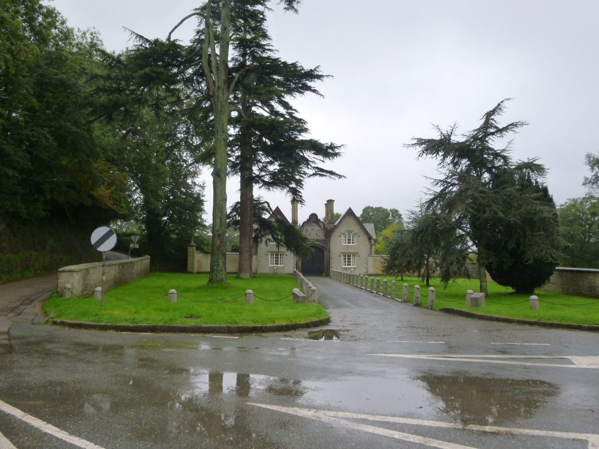
The principal C19 approach to Tregothnan was from the north along a picturesque drive which is entered through a mid C19 gatehouse (listed grade II) at Tresillian c 5km north of the house. The two-storey stone gatehouse comprises a pair of lodges linked by a massive Tudor-gothic arch containing traceried timber doors and surmounted by a carved heraldic achievement. Quadrant walls with terminal piers surmounted by carved lions flank the gatehouse, while to the north, between the gatehouse and the public road, areas of lawn planted with mature cedars are retained by low granite walls (listed grade II). Granite bollards linked by chains extend from the carriage arch along the drive and enclose the side of the lawns adjacent to the public road, returning to the piers which terminate the quadrant walls (all listed grade II). Within the site the tarmacked north drive leads c 190m south-west through an avenue of ilex oaks (replanted late C20), before entering an informal avenue of mature ilex oaks which extends c 550m south-west.
Passing from this informal avenue the drive continues south-west with rock faces and areas of principally deciduous woodland to the south-east, and the tidal Tresillian River to the north-west. There are views north from the drive across the river to the grounds of Pencalenick. After c 2.5km the drive rises slightly with riverine oak woodland on the north-west-facing slope between the drive and the river, while after c 3km the drive crosses a dam which retains Merther Pond, a former tidal creek. Some 450m south of Merther Pond the drive turns south-east and ascends a wooded side valley, passing under a simple stone arch (c 1825, listed grade II) which carries the public road to the hamlet of Mertherlane. Sweeping east and south the drive crosses a further public road before turning south-south-west to pass in an approximately straight line through woodland which includes groups of ornamental conifers, to reach the forecourt to the north-east of the house. The final 370m of the drive is flanked by mature rhododendrons.
The north drive was constructed in the early C19 and may have formed part of Repton's early C19 improvements; it is shown on the Tithe map of 1840 but at this date the final 200m of the drive ran to the south-east of its present course to enter the forecourt at its north-east corner. The course of the drive and forecourt appear to have been altered to their present form by W A Nesfield for the second Earl in the mid C19; plans and elevations for this work survive and are attributed to Nesfield (private collection).
Principal Building
Tregothnan House (listed grade I) stands on a level spur of high ground above the Truro River and the River Fal. The house assumed its present form in 1816-18 when William Wilkins remodelled a mid C17 house for the fourth Viscount Falmouth in a Tudor-gothic style. The house was further enlarged by Lewis Vulliamy in 1842-8 for the second Earl of Falmouth, at which time the forecourt to the north of the house was remodelled. The two-storey building is constructed in stone with three taller towers and many tall terracotta and stone chimney stacks which combine to create a picturesque outline to the building. The entrance facade is to the north with a central section containing the entrance porch by Wilkins flanked by bays added by Vulliamy. The south or garden facade incorporates part of the 1650 house, while the east facade is largely the work of Wilkins.
Gardens and Pleasure Grounds
The formal gardens lie to the south and south-east of the house, while informal pleasure grounds extend to the south-east and south-west.
A terrace extends below the south-west facade of the house, with stone steps to the south-east descending to the parterre terrace. Rectangular on plan, the terrace is retained to the south-west by a massive, mid C19 buttressed stone wall and low parapet (listed grade II) which separates the terrace from the deer park. A perimeter gravel walk encloses the terrace, while a central gravel walk divides it into two rectangular lawns; the larger lawn to the east of the central walk is at a lower level. The lawns have quadrant-shaped flower beds at each corner, and a central, slightly sunken oval area which in the late C20 replaced mid C19 geometric parterres designed by W A Nesfield (Tooley 1994). In the late C17 Celia Fiennes described formal gardens comprising 'gravel walks around and across ... the squares full of goosebery and shrub-trees ... like a kitchen garden ... out of which is another garden and orchard, which is something like a grove - green walks with rows of fruit trees' (Morris 1995). The Tithe map (1840) shows the park extending up to the house. The parterre terrace formed part of alterations designed by W A Nesfield in the mid C19 (Tooley 1994).
A formal walk aligned on the south-east facade of the house and planted with alternate pines and myrtles extends c 290m south-east through the pleasure grounds, before turning east-south-east for c 130m. An informal gravelled walk, the Deer Park Walk, leads from the south-east corner of the parterre terrace into the pleasure grounds passing through rhododendrons and ornamental shrubbery adjacent to the boundary between the pleasure grounds and the deer park, allowing occasional vistas into the park. Some 240m south of the house the informal walk crosses a lime avenue which extends c 100m south-west to the ha-ha forming the park boundary. The Bowling Green, a large, roughly oval lawn enclosed by rhododendrons lies at the west end of a shrubbery walk, the Quarter Mile Walk, c 100m south-east of the house. The Bowling Green and lime avenue are shown on the Tithe map of 1840 and may survive from an C18 layout (N Jeans pers comm, 2000).
A shallow flight of stone steps rises to the Quarter Mile Walk which extends c 370m east-south-east through the pleasure grounds, and which is terminated at its eastern end by a low granite bench seat. A pair of ornamental stone niche seats surmounted by ball finials are placed in shrubbery to the north of the Quarter Mile Walk, that to the east being aligned on an avenue of tree ferns which descends into the informal pleasure grounds. A C19 rustic timber summerhouse with a shingled roof stands c 250m east of the Bowling Green. The summerhouse overlooks a rectangular lawn with a semicircular extension on its south side, which is enclosed by rhododendrons. A central walk leads c 50m south from the summerhouse to a circular flower bed which contains a late C20 sculpture of a falcon set on a stone pedestal. The formal walks to the north of the pleasure grounds and the formal lawn to the south of the summerhouse are not shown in their present form on the Tithe map (1840), and formed part of the scheme designed by W A Nesfield in the mid C19. Further development took place in the early C20 (OS).
Some 370m south-east of the house, an avenue of Chusan palms leads to Snowdrop Hill, an area of informal ornamental planting. To the south a sunken garden is planted with Chusan palms and bog plants. Now (2000) cleared from mid C20 scrub, the sunken garden was created c 1900 by enclosing a strip of parkland adjacent to the boundary of the pleasure grounds. In the valley to the east of Snowdrop Hill a chain of three pools is surrounded by bog plants, while grass walks ascend a further hill to the south-east through the Arboretum. Today (2000) the Arboretum comprises a collection of late C20 conifers and other ornamental trees planted to replace C19 specimens destroyed in late C20 gales.
To the west of the parterre terrace, mature ilex oaks screen service buildings to the south-west of the house. An informal gravel walk at the south-west corner of the parterre terrace extends c 240m south-west through an area of trees underplanted with a significant collection of camellias to reach the walled garden. This walk and shrubbery formed part of Repton's early C19 scheme for Tregothnan (Falmouth 1970).
Park
The park to the south of the house remains a deer park grazed by a wild herd of fallow deer (N Jeans pers comm, 2000). The park is enclosed by metal fencing and stone walls, and to the south-west adjoins oak woodland on the River Fal. To the south it is bounded by the River Fal, while to the east it adjoins woodland and a C19 plantation, The Rookery. The park is undulating, with a deep valley containing a chain of four rectangular pools c 320m south-west of the house extending south-west to the Truro River. A further rectangular pond or reservoir lies c 350m south-east of the house, while a stream flows south through a lightly wooded valley c 670m south-east of the house to the River Fal. There are ornamental groups of trees on high ground to the south and south-east of the house, and on a north-west-facing slope c 590m south-west of the house. The south park was established as a deer park by the mid C17 (Pett 1998) and was noted by Celia Fiennes in the late C17 (Morris 1995). In 1867 it contained a herd of 100 fallow deer (Shirley 1867).
To the west and north-west of the house the north-west-facing slope which descends to the Truro River is today (2000) agricultural land, but is shown as parkland on the 1883 OS map. To the south this area is enclosed by Barnclose Plantation, an area of mixed woodland of early C19 origin (N Jeans pers comm, 2000); to the north it is enclosed by further belts of woodland, while to the west Cove Wood is planted on the steep slope above the Truro River. In a valley c 210m north-west of the house late C19 kennels (OS) were developed from an early C19 deer barn (Tithe map, 1840).
A carriage drive extends through Cove Wood along the shore of the Truro River, passing two boathouses and an early C19 limekiln (listed grade II) c 800m south-west of the house. This drive continues north (beyond the boundary of the registered site) along the Truro River to reach a ferry at Malpas Point, and thence north-east along the Tresillian River to join the north drive c 1.3km north of the house. A further carriage drive follows the southern boundary of the park to the south of the house, connecting to the east with a drive (beyond the registered site) which follows the River Fal to Lamorran c 2km east of the house.
Kitchen Garden
The kitchen garden occupies a south-east-facing slope c 240m south-west of the house. Rectangular on plan, the garden is enclosed by brick walls c 3m high to the north-east, north-west, and south-west; the wall to the south-east is lower and allows a view out into the park. A late C19 brick and timber lean-to glasshouse stands against the inner face of the north-west wall to the north of the principal entrance to the garden. This glasshouse comprises approximately one third of the original structure (N Jeans pers comm, 2000), while the foundations of further glasshouses and associated structures remain to the west. The garden is terraced and is today (2000) used as a nursery. A Tudor-gothic arched doorway at the north corner of the garden leads from the upper terrace to the south-west shrubbery walk.
To the north-west of the walled garden is a service yard enclosed by a hedge to the north-west, and entered through two gateways flanked by tall granite piers. To the north of the yard is a range of sheds and a cart hovel containing an early C20 soil-sterilising oven. A range of bothies stands against the outer face of the north-west wall of the kitchen garden, while to the south-west are the remains of a late C19 or early C20 straw-covered apple store. A triangular plot to the east of the kitchen garden and to the west of the park is planted with mature standard apple trees, and to the north-east there is a further rectangular orchard. The present disposition of kitchen garden and orchard reflects that shown on the Tithe map (1840).
References
W Hals, Parochial History of Cornwall iii, (1737), p 344
J Tonkin, Parochial History of Cornwall iii, (1742), p 345
C S Gilbert, An Historical Survey of the County of Cornwall ii, (1820), pp 834-835
J Britton and E W Brayley, Devonshire and Cornwall Illustrated (1832), p 24
Gardener's Magazine 13, (1837), p 121
F O Morris, A Series of Picturesque Views ... 5, (1866-80), p 29
E P Shirley, Some Account of English Deer Parks (1867), p 88
J Horticulture Cottage Gardener 58, (1877), pp 269(71, 288-290
Gardeners' Chronicle, i (1909), pp 289-290
Country Life, 119 (17 May 1956), pp 1051-1054; (24 May 1956), pp 1112-1115
D Stroud, Humphry Repton (1962), p 77
Lord Falmouth, A Short Account of Tregothnan and the Gardens (1970)
N Pevsner and E Radcliffe, The Buildings of England: Cornwall (2nd edn 1970), p 224
G Carter et al, Humphry Repton (1982), p 150
M Tooley (ed), William Andrews Nesfield 1794-1881 (1994), p 30
C Morris (ed), The Illustrated Journals of Celia Fiennes 1685-c 1712 (1995), pp 205-206
D E Pett, The Parks and Gardens of Cornwall (1998), pp 97-99
Maps
Tithe map for St Michael Penkevil parish, 1840 (TM150), (Cornwall Record Office)
OS 6" to 1 mile: 1st edition surveyed 1878, published 1883
2nd edition revised 1905, published 1908
Archival items
Humphry Repton, Red Book for Tregothnan, Cornwall, 1809 (private collection)
W A Nesfield plans, mid 19th century (private collection)
Personal communication from Shirley Evans
Description written: February 2000
Amended: October 2000, July 2001
Edited: October 2001
- Visitor Access, Directions & Contacts
- History
The following is from the Register of Parks and Gardens of Special Historic Interest. For the most up-to-date Register entry, please visit the The National Heritage List for England (NHLE):
www.historicengland.org.uk/listing/the-list
HISTORIC DEVELOPMENT
Tregothnan was acquired by John Boscawen on his marriage with the heiress of John Tregothnan in 1334 (Tonkin 1742). Following damage during the Civil War, Hugh Boscawen (d 1701) abandoned the medieval house and built a new dwelling on a site to the south-east in 1650; part of this structure remains in the present mansion. Celia Fiennes, a relative by marriage, visited Hugh Boscawen in 1698 and described the house standing 'on a high hill in the middle of a parke', and the formal gardens (Morris 1995). Hugh Boscawen was succeeded by his nephew, also Hugh, who was created Viscount Falmouth in 1720 for services as Comptroller of the Household to George I. The first Viscount's second son, Admiral the Hon Edward Boscawen (d 1761), was a noted naval commander in the Seven Years' War, and it was his son, George Evelyn, who succeeded as third Viscount in 1782. The third Viscount died in 1808 and was succeeded by his son Edward, who was created first Earl of Falmouth in 1820. The fourth Viscount and first Earl was one of a group of Cornish Whig politicians and landowners closely associated with William Pitt the Younger. The group, which included Reginald Pole Carew of Antony, Francis Gregor of Trewarthenick, Francis Glanville of Catchfrench, and Lord Eliot of Port Eliot, also consulted Humphry Repton (1752-1818) in the early 19th century on the improvement of their estates. Repton provided a Red Book for Tregothnan in 1809, and advised on the structural condition of the house, which was largely rebuilt by William Wilkins in 1816-1818. The second Earl, who succeeded in 1821, commissioned Lewis Vulliamy to make additions to the house and William Andrews Nesfield (1793-1881) to alter the pleasure grounds and drive. The second Earl died unmarried in 1852, when the earldom became extinct, and he was succeeded as sixth Viscount by his cousin Evelyn (1819-1889), who, with his brother the Honourable and Reverend John Townshend Boscawen of Lamorran, introduced collections of rhododendrons and camellias to the grounds. The seventh Viscount (1847-1918) inherited the barony of Le Despencer from his mother in 1891. Today (2000) Tregothnan remains in private ownership.
- Associated People
- Features & Designations
Designations
The National Heritage List for England: Register of Parks and Gardens
- Reference: GD1646
- Grade: II*
Plant Environment
- Plant Type
- Arboretum
Features
- Tower
- Description: The tower of the old church at Kea about 1.5 kilometres west of the house which was purchased by the Earl of Falmouth in the early-19th century serves as an eyecatcher from the north-west park.
- House (featured building)
- Description: A new house was built around 1650, parts of which remain. The house was largely rebuilt by William Wilkins in 1816-1818. Lewis Vulliamy made additions after 1821.
- Earliest Date:
- Latest Date:
- River
- Description: The site is bounded to the west by the Truro River, and to the south by the River Fal, while to the north-west the early 19th century picturesque north drive adjoins the Tresillian River.
- River
- Landscape garden
- Formal garden
- Woodland garden
- Parkland
- Key Information
Type
Garden
Purpose
Educational
Plant Environment
Plant Type
Principal Building
Domestic / Residential
Survival
Extant
Hectares
150
Open to the public
Yes
Civil Parish
St. Michael
- References
References
- Carter, G et al {Humphry Repton landscape gardener 1752-1818} (1982) p 150 Humphry Repton landscape gardener 1752-1818
- {English Heritage Register of Parks and Gardens of Special Historic Interest} (Swindon: English Heritage 2008) [on CD-ROM] Historic England Register of Parks and Gardens of Special Historic Interest
- Stroud, D {Humphry Repton} (1962) p 77 Humphry Repton
- Pevsner, N and Radcliffe, E {The Buildings of England: Cornwall} (Harmondsworth: Penguin, 1970) p 224 The Buildings of England: Cornwall
- Pett, D E {The Parks and Gardens of Cornwall} (1998) pp 97-99 The Parks and Gardens of Cornwall