Introduction
Shortgrove Park has the remains of an 18th-century landscape park covering approximately 176 hectares. The land was divided in the mid- and later 20th century.
Terrain
The buildings sit centrally on the site and the ground falls away to the west to the banks of the River Cam which flows along the western boundary.www.historicengland.org.uk/listing/the-list
A landscape park laid out by Lancelot Brown between the 1750s and 1770s overlying an early C18 formal landscape surrounding the site of Shortgrove Hall, with mid C18 walled gardens developed by William Chater in the 1860s.
DESCRIPTION
LOCATION, AREA, BOUNDARIES, LANDFORM, SETTING
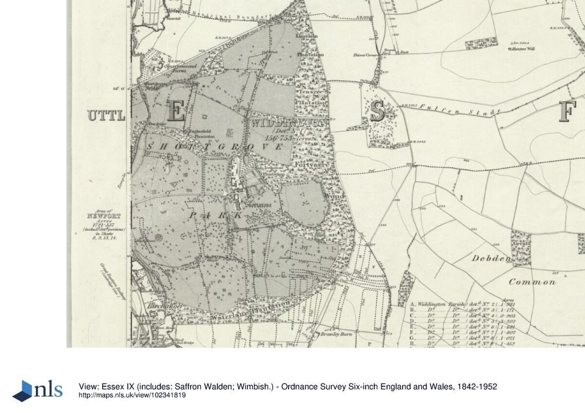
Shortgrove Hall lies on the north side of the Essex village of Newport, c 8km south of Saffron Walden. The c 176ha park sits in a rolling landscape in a rural setting surrounded by farmland. The northern boundary is formed by Sparrowsend Hill, the eastern and southern boundaries by farmland, and the western boundary by the Newport to Saffron Walden road (formerly the A11). The buildings sit centrally on the site and the ground falls away to the west to the banks of the River Cam which flows along the western boundary, giving views out across the countryside.
ENTRANCES AND APPROACHES
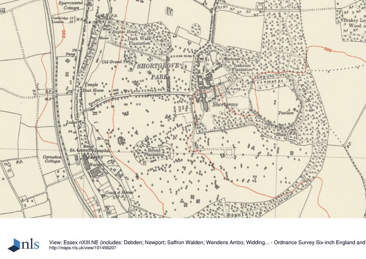
The main approach to Shortgrove is from midway along the western boundary, through a pair of wrought-iron gates hung on mid C18 red-brick gate piers (listed grade II), set beside the late C19 Front Lodge. The drive, lined with trees of mixed species including large cedar, lime, and oak, crosses the River Cam via a three-arch stone bridge (Matthew Brettingham, listed grade II) and runs east through the park to arrive at the stable courtyard in the centre of the park. A second set of gate piers on the south side of the stable courtyard entrance leads the drive south-east to the site of the mansion. A second drive enters the park off Sparrowsend Hill, c 1.1km to the north of the mansion site. This lesser drive passes the early C19 cottage-style Haytos Lodge, the oak- and lime-lined drive running south to join the west drive beside the stable courtyard. Both drives are evident on the 1786 estate survey, the western drive having been the subject of one of Lancelot Brown's contracts.
PRINCIPAL BUILDING
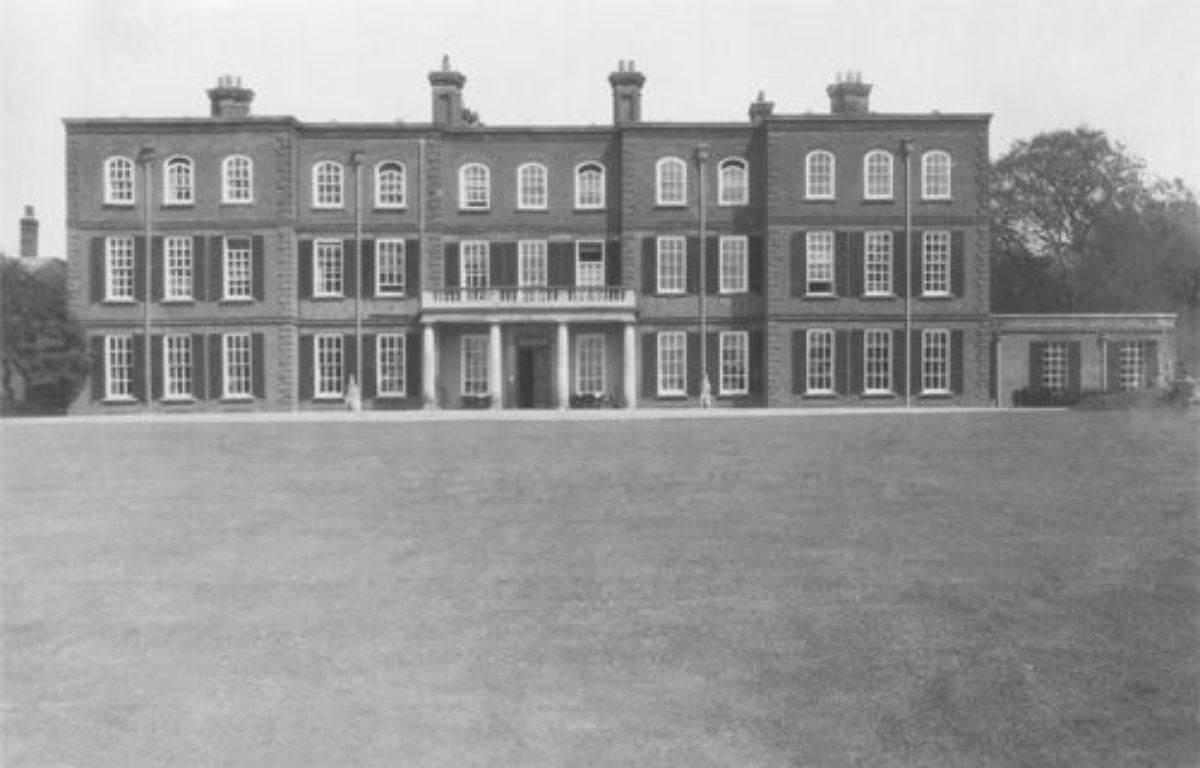
Shortgrove Hall was built by the Earl of Thomond early in the C18 but was destroyed by fire in 1966. Part of the north wall, incorporating a small niche, is all that survives. A replacement mansion on the same site is currently (2000) under construction.
Immediately to the north-east of the house site is the stable courtyard (listed grade II*), now (2000) a range of private dwellings known as North House, Clock House, and South House. Originally built during the mid C18 improvements of the estate, the classical main block faces west and has a central clock tower with open cupola surmounted by a dome. The west front faces onto the former walled kitchen gardens (see below).
GARDENS AND PLEASURE GROUNDS
The site of the gardens which surrounded the former mansion to south and east are now laid to grass, within the ha-ha constructed by Brown in the mid C18. At this time they were said to enclose lawns running up to the Hall but by the mid C19 had been turned into more elaborate gardens including terraces, a Rosery, a Flower Garden, and an Italian Garden (Muilman 1770; Sale catalogue, 1889). A mid C20 tennis court stands c 200 to the south of the mansion site. The remains of the C19 wooded pleasure grounds survive running along the southern boundary of the gardens into an area of woodland south-east of the mansion site which extends as far as the eastern boundary of the park. Within the wood traces of exotic plantings and some of the paths survive (2000) together with the remains of a moat which surrounded an earlier house set within these woods and shown to still exist on the 1786 estate map. The 1889 sale catalogue describes the pleasure grounds at the time as 'the embodiment of natural beauty and artistic design', reached from the house lawn by the Mile Walk 'unsurpassable in the sylvan beauties of its surroundings' and linked to The Green Drive in the woodland, 'running for part of its length through a fine avenue of silver firs'.
PARK
The park at Shortgrove lies to the north, west, and south of the mansion site and is almost entirely enclosed by boundary plantations. To the north the park is divided by hedges or plantations into fields, the pattern of which has altered little since the 1786 estate survey was drawn. To the north of the stable courtyard and walled garden is an estate yard which includes an early C18 red-brick dovecote (listed grade II), on the north side of which stands Le Pavillon, a mid C20 house which includes in its gardens the pond dug by Lancelot Brown in the mid C18. Some 150m to the north-west of Le Pavillon stands a row of mid C19 estate cottages, while c 120m to the north-east is the C19 Gardener's Cottage.
To the west of the mansion site, on the north side of the west drive the park is retained under pasture and is divided from the north park by Dark Walk Plantation. This plantation is linked to the drive by the horse chestnut-lined Dark Walk, which runs north across the open park and then turns north-west to run through Dark Walk Plantation to a footbridge over the Cam on the western boundary. This arrangement of the landscape is shown in place on the 1786 estate survey, which also records a path (no longer visible) continuing south through the western boundary Temple Plantation, to a classical temple built by Matthew Brettingham on the west bank of the Cam. The temple survived until at least 1927 (OS).
The south park, covering the southern half of the site as here registered, is now (2000) mainly under the plough although it retains the outline structure of the landscape laid out by Lancelot Brown between 1753 and the 1770s. This included the widened River Cam, the ha-has, mature oak and sweet chestnut plantings south of the mansion site, and the boundary plantations. Round Plantation in the middle of the south park also survives, although is now (2000) two Brown clumps joined together.
KITCHEN GARDEN
The walled kitchen garden is located c 100m to the north-east of the mansion site, behind the stable courtyard; it now (2000) forms the private gardens attached to North House, Clock House, and South House. The walled garden is shown in this position, together with its string of ponds which survive along the eastern boundary, on the 1786 estate map. Both were developed in the latter part of the C19 by the local Essex nurseryman and landscape gardener William Chater as garden areas and some elements of his designs survive within the modern private gardens. These include yew-hedged enclosures, a summerhouse, a small grotto pool, a long canal with temple, and a fine range of restored glasshouses located along the north wall, facing south onto the remains of the orchard.
REFERENCES
P Morant, The History and Antiquities of the County of Essex (1763-8)
P Muilman, A New and Complete History of Essex I, (1771)
Gardeners' Chronicle, (1885)
D Stroud, Capability Brown (1975), pp 239-40
N Pevsner and E Radcliffe, The Buildings of England: Essex (1979), p 306
Shortgrove Park, (Jacquelin Fisher Associates 1990) [report to support planning application; copy on EH file]
A Archer (ed), A village in time: the history of Newport (1995)
Maps
Survey of the Shortgrove Estate, 1727 (copy in Essex Record Office: T/M 298)
J Chapman and P Andre, A map of the county of Essex from an actual survey ..., 1777 (Essex Record Office)
Footpath and bridleway diversion map, 1784 (Q/Rhi 3/10b), (Essex Record Office)
W Smith, draft map of The manors of Newport Pond and Shortgrove Hall, 1786 (D/DU 205/19), (Essex Record Office)
OS 25" to 1 mile:
1st edition published 1887
2nd edition published 1897
3rd edition published 1927
Archival items
Lancelot Brown's contracts for work at Shortgrove Hall, 1750s-1770s (Petworth Archives PHA 7428; estate correspondence PHA 5K-7), (West Sussex Record Office)
Sale catalogue, 1889 (B1574), (Essex Record Office)
Sale catalogue, 1894 (A1055), (Essex Record Office)
Description written: November 2000 Amended: April 2001
Register Inspector: EMP
Edited: September 2001
- Visitor Access, Directions & Contacts
- History
The following is from the Register of Parks and Gardens of Special Historic Interest. For the most up-to-date Register entry, please visit the The National Heritage List for England (NHLE):
www.historicengland.org.uk/listing/the-list
HISTORIC DEVELOPMENT
At the beginning of the C16 the manor of Shortgrove was acquired by the Finderne family. They sold it to the Elrington family who owned the Hall for three generations before it was purchased by Giles Dent, a London merchant, in c 1653. His son, also Giles,who inherited the estate in 1671, pulled down the old house in 1684 and built an elegant new mansion. Shortly before he died in 1712, the estate was sold to Henry O'Brien, Earl of Thomond, who added wings to the house. O'Brien also laid out gardens and canals, fed from the River Cam via an engine designed by Dr Desaguliers (Morant 1763(8). When Henry died in 1741, he left Shortgrove to his nephew Percy Wyndham, who took the name of O'Brien and the title of Earl of Thomond in 1756. Wyndham commissioned Matthew Brettingham to make further alterations to the house, and in 1753 called in Lancelot Brown (1716-83) to begin the laying out of new grounds around the house. Between then and the 1770s Brown also made substantial changes to the park. His work is recorded on an estate survey dated 1786. After Thomond died in 1774, Shortgrove was inherited by the Earl of Egremont, whose seat was at Petworth in Sussex (qv) and the Earl transferred the Shortgrove estate to his younger brother Percy Charles Wyndham. Between 1784 and 1788 footpaths and bridleways were closed, and a new road to Saffron Walden made along the western boundary of the park (ERO). Shortgrove was sold in 1802 to Joseph Smith whose son William inherited debts as well as the estate in 1822. The Hall was therefore let until 1837 when William Smith returned to take up residence. He lived at Shortgrove until the 1870s, during which time he and the Essex landscape gardener William Chater laid out expansive gardens to the east and north-east, including developing the area within the old walled gardens. The park however was left much as Brown had designed it. The result is noted in Chater's obituary published in the Gardeners' Chronicle in 1885, on the OS 1st edition 25" map of 1887, and in the sale catalogue which was produced in 1889 when William Smith died. Following several brief ownerships Shortgrove was purchased by Carl Meyer who, together with his wife Adele, lived on the estate in great style. By 1924 Adele was a widow and she left Shortgrove, selling the property to Captain Frederick Montague of Lynford Hall, Norfolk (qv). The estate came up for sale again in 1938 when it was purchased by the Butler family who retained most of the park but in 1963 sold the Hall and its immediate surroundings to a property speculator, Geoffrey Allen. Following a fire in 1966, the remains of the Hall were demolished and a small replacement erected, while the stables were converted into several private dwellings. In 1999 the mansion site, together with 8ha of land, were sold to the Scruby family who removed the 1980s house and began the erection of a new mansion. The site remains (2000) in divided private ownership.
Period
18th Century (1701 to 1800)
- Associated People
- Features & Designations
Designations
The National Heritage List for England: Register of Parks and Gardens
- Reference: GD1736
- Grade: II
Features
- House (featured building)
- Description: The hall was destroyed by fire in 1966 and demolished. It was replaced by a new house, which was removed after 1999 and replaced by a new mansion.
- Earliest Date:
- River
- Description: The River Cam flows along the western boundary.
- Parkland
- Key Information
Type
Park
Purpose
Ornamental
Principal Building
Domestic / Residential
Period
18th Century (1701 to 1800)
Survival
Extant
Hectares
176
Open to the public
Yes
Civil Parish
Newport
- References
References
- Stroud, D {Capability Brown} (1975) pp 239-240 Capability Brown (Country Life article)
- {English Heritage Register of Parks and Gardens of Special Historic Interest} (Swindon: English Heritage 2008) [on CD-ROM] Historic England Register of Parks and Gardens of Special Historic Interest
- Pevsner, N and Radcliffe, E {The Buildings of England: Essex} (Harmondsworth: Penguin, 1965) p 306 The Buildings of England: Essex