Introduction
Sheringham Hall has a landscape park designed by Humphry Repton, covering 130 hectares, set in a wider agricultural landscape of 500 hectares. The park contains mature woodlands and a large variety of rhododendrons introduced in the early-20th century. Other planting includes 15 varieties of magnolia and large specimen pieris. A garden temple was constructed in 1975 and the park also has several viewing towers.
Terrain
The topography is dramatic for Norfolk, both within the woods and in the open parkland, featuring steep rises and coastal views.www.historicengland.org.uk/listing/the-list
Early 19th-century hall by John Adey Repton set within a landscape park for which Humphry Repton produced a Red Book in 1812, his last commission.
DESCRIPTION
LOCATION, AREA, BOUNDARIES, LANDFORM, SETTING
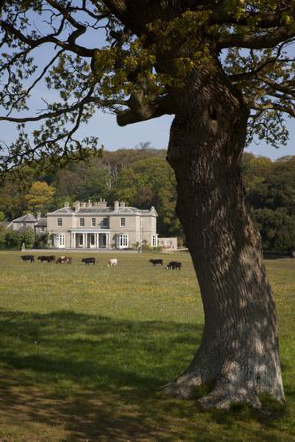
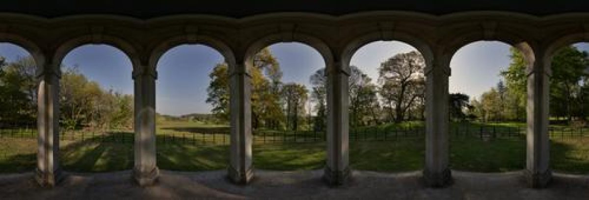
Sheringham Park is located to the north of the A148 Holt to Cromer road on the north Norfolk coast, c 8km west of Cromer and immediately to the west of Upper Sheringham village. The site enjoys an open coastal setting, surrounded to east, west, and south by farmland and with the sea to the north, c 1km away. The registered park covers c 130ha, enclosed on all boundaries by woodland belts and plantations. Larger blocks of woodland lie to the north where Oak Wood is bounded to east and west by gaps allowing views to the sea; and to the south where the extensive Sheringham Wood completely encloses the park. The topography is dramatic for Norfolk, both within the woods and in the open parkland. The steep rise immediately north of the Hall is surmounted by a gazebo (late C20) giving 360 degree panoramic views. A second steep rise, in the open park to the south of the Hall, is topped by a temple (late C20) offering fine views north to the house and the coastline beyond.
ENTRANCES AND APPROACHES
The main entrance to the park is from the A148 in the south, past Ivy Lodge (listed grade II). This cottage-orné two-storey lodge was designed originally by Humphry Repton but was much altered in 1905 for Henry Morris Upcher. The drive, known as the Upper Approach, runs through Sheringham Wood, past the rhododendron collections, to emerge north of The Rookery before turning north-east to arrive at the stable block on the west front of the Hall. The drive was carefully sculpted by H Repton out of the existing woods to offer the best views of the sea and of the Hall itself, which is not seen until the drive emerges at The Rookery, at a point known as The Turn. The treatment of the Upper Approach was considered by Abbot Upcher to be Repton's greatest achievement at Sheringham (guidebook). A second drive enters the park in Upper Sheringham village, runs west past Hall Farm and a two-storey flint, brick, and pantile lodge to join the Upper Approach c 100m south of the Hall. To the north of the Hall, on the north-west corner of Oak Wood, stands the two-storey flint and tile West Lodge which is no longer connected to the Hall by a drive.
PRINCIPAL BUILDING
Sheringham Hall (listed grade II*) is a two-storey, five-bay, gault brick and slate country house, built in a simple Italian villa style. It stands in the lea of Oak Wood in the northern part of the site. The main facade looking south across the park has five bays, the three central bays being recessed with a colonnade in front of six Doric columns. The entrance front faces west and is of three bays with a projecting central porch supported by two pairs of Roman Doric columns, above which runs a pediment embellished with the Upcher crest. A service wing projects west from the north end of the west front. Immediately to the west of the Hall stand the stables and coach house (listed grade II), enclosed by courtyard walls. In the centre of the coach house is a clock turret and bell under a leaded cupola with gilded weathervane. Both the Hall and the stable block were designed by Humphry and John Adey Repton between 1812 and 1819 for Abbot Upcher, the majority of the architectural work being attributed to the son rather than the father.
GARDENS AND PLEASURE GROUNDS
The gardens lie mainly to the east of the Hall although to the south a small lawn is enclosed by wrought-iron railings terminated by gault brick piers topped by stone urns (all listed grade II). The railings were designed by H and J A Repton and erected when the Hall was built. The railings continue east of the Hall to enclose the east lawn which is adorned with some mature trees and leads on to a series of shrubbery walks which link the gardens to the walled kitchen garden some 250m to the north-east. These are all that remain of the terrace and flower garden laid out at the suggestion of H Repton in the early C19.
PARK
The open area of grassland in Sheringham Park extends to c 35ha, although this is bounded by extensive areas of woodland which together form a park of c 130ha. The northernmost hill is covered by the deciduous Oak Wood, while the rolling open parkland runs from north-west to south-east through the northern half of the site, planted with a few trees of oak and beech. These are concentrated on the knolls in the park. Here, c 700m south-east of the Hall, stands a temple, erected in 1975 following a design by Humphry Repton which was intended for another high point in the park but was never built. There are fine views north from here, with the Hall Farm complex being a visually important element. The remainder of the registered site to the south and west is covered by Sheringham Wood, the eastern half of which is planted with oaks interspersed with pine which form a canopy for the collection of rhododendrons, camellias, and magnolias. This merges into a conifer plantation, studded with a few very mature oak, sweet chestnut, and beech, to the west which is cut through with rides and paths. To the west of Ivy Lodge on the southern boundary is a small area of open farmland (outside the registered area), enclosed to the south by Bodham Covert.
The open park was created by Abbot Upcher, who records its initial seeding in his journal of 1816 (guidebook) and was embellished with trees such as chestnut, hawthorn, and yew at Repton's suggestion. The woods were initially planted in the mid C18 by the owner of the time, Cook Flower, but were augmented and extended by Repton and Upcher who also established Bodham Covert, the southern boundary belt. The ornamentation of Sheringham Wood with flowering woodland shrubs such as rhododendrons dates from the mid C19 onwards.
KITCHEN GARDEN
The walled kitchen garden lies c 250m north-east of the Hall and is screened from the park on its south side by a belt of ornamental trees and shrubs. A gardener's cottage is attached to the east wall and large C19 glasshouses to the south side of the south wall. Internally the space is presently (1999) laid to grass. Construction of the walled garden began at the direction of Repton in 1815 and was completed by 1816.
REFERENCES
H Repton, Sheringham Red Book (1976 facsimile) [copy in Norfolk Record Office]
H Repton, Fragments on the Theory and Practice of Landscape Gardening (1816), pp 195-212
Country Life, 121 (31 January 1957), pp 192-5; (7 February 1957), pp 236-9
D Stroud, Humphry Repton (1962), pp 152-60
E Malins, The Red Books of Humphry Repton (1976), pp 27-30
Landscape Design 135, (1981), pp 26-8
G Carter et al, Humphry Repton (1982), pp 55, 159
D Watkin, The English Vision (1982), pp 82-3
T Williamson, The archaeology of the landscape park, BAR British Series 268 (1998), pp 275-7
Sheringham Park, guidebook, (National Trust 1998)
Maps
W Faden, A new topographical map of the county of Norfolk, 1797 (Norfolk Record Office)
A Bryant, Map of the county of Norfolk, 1826 (Norfolk Record Office)
OS 6" to 1 mile: 1st edition published 1885; 2nd edition published 1907
OS 25" to 1 mile: 1st edition published 1886; 2nd edition published 1907
Description written: May 1999
Edited: March 2001
- Visitor Access, Directions & Contacts
Telephone
441263820550Access contact details
http://www.nationaltrust.org.uk/place-pages/296/pages/opening-times-calendar
- History
The following is from the Register of Parks and Gardens of Special Historic Interest. For the most up-to-date Register entry, please visit the The National Heritage List for England (NHLE):
www.historicengland.org.uk/listing/the-list
HISTORIC DEVELOPMENT
Although no park existed at Sheringham before Repton was called in to advise, the owner of the Sheringham estate during the late 18th century, Cook Flower, began the creation of the landscape which exists today by planting extensive woods on the hilltops and leaving the undulating land beneath to undivided arable. The estate was purchased in 1811 by Abbot Upcher who immediately commissioned Humphry Repton (1752-1818), and his architect son John Adey Repton (1775-1860), to design a new house, to be known as Sheringham Bower, as a replacement for the old house which stood on a different site some 600 metres to the east. It took Upcher and the Reptons until 1813 to agree on the new site and to begin the work, which included a terrace garden on the north side of the house. The building of the house and the laying out of the park and garden ran concurrently and were all largely, but not entirely complete by 1817. Abbot Upcher died in 1819 and his wife left the house unfinished and empty. It was her son Henry Ramey Upcher who completed the work and took up residence in 1839 and the landscape continued to develop according to Repton's principles. A collection of rhododendrons was started in the woodlands in the 1850s. Henry Morris Upcher succeeded to the estate in 1892 and added further to the rhododendron collections with seed supplied by the plant collector Ernest Wilson. Henry Edward Sparke (later Sir Henry) Upcher inherited after the First World War and continued to farm the estate until after the Second World War. His son Thomas succeeded in 1954, further improving the plant collections and erecting a temple in the park. The property was given to the National Trust by the Upcher family in 1987 and remains (1999) in their ownership.
- Associated People
- Features & Designations
Designations
The National Heritage List for England: Register of Parks and Gardens
- Reference: GD2022
- Grade: II*
Features
- Vantage Point
- Description: Viewing towers allow views of the gardens and coastline
- Temple
- Earliest Date:
- Latest Date:
- Tree Feature
- House (featured building)
- Earliest Date:
- Latest Date:
- Plantation
- Description: The park is enclosed on all boundaries by woodland belts and plantations.
- Gazebo
- Description: The steep rise immediately north of the Hall is surmounted by a gazebo.
- Earliest Date:
- Latest Date:
- Key Information
Type
Park
Purpose
Ornamental
Principal Building
Domestic / Residential
Survival
Extant
Hectares
130
Open to the public
Yes
Civil Parish
Upper Sheringham
- References
References
- Carter, G. et al, {Humphry Repton Landscape Gardener 1752-1818} (Norwich: Sainsbury Centre for Visual Arts, 1982), pp. 55, 159 Humphry Repton landscape gardener 1752-1818
- {English Heritage Register of Parks and Gardens of Special Historic Interest}, (Swindon: English Heritage, 2008) [on CD-ROM] Historic England Register of Parks and Gardens of Special Historic Interest
- Stroud, D., {Humphry Repton} (London: Country Life, 1962), pp. 152-60 Humphry Repton
- Related Documents