Introduction
Wolterton Hall has an 18th-century park and woodland set within a larger agricultural estate. The park contains evidence of the village of Wolverton, including the church tower which is still visible. The 18th-century walled garden is currently used as a smallholding by an organic food company.
Terrain
The ground has a gently rolling character with a slight fall southwards towards the course of the Bure.The following is from the Register of Parks and Gardens of Special Historic Interest. For the most up-to-date Register entry, please visit The National Heritage List for England (NHLE):
An early 18th-century park and woodland designed as a collaboration between Thomas Ripley, Charles Bridgeman, Horatio Walpole and others, surrounding an early 18th-century Palladian mansion with mid-19th-century gardens laid out by William Sawrey Gilpin.
Location, Area, Boundaries, Landform and Setting
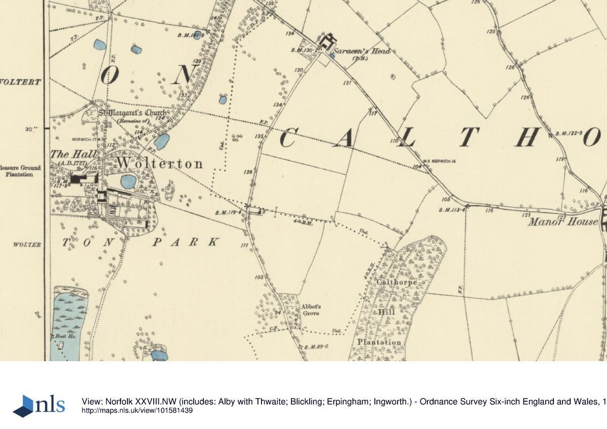
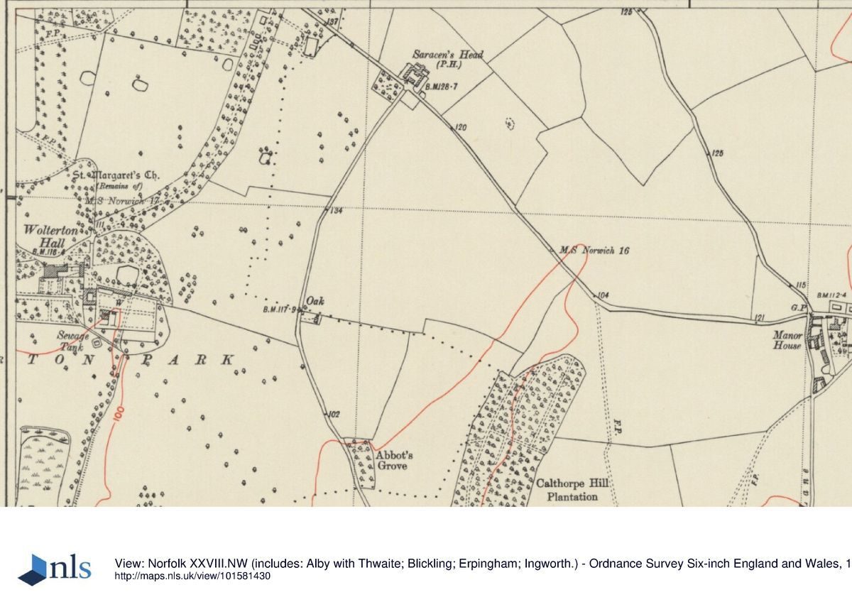
Wolterton Park is located c 3.5km north of Blickling, itself c 19km north of Norwich in a rural part of Norfolk on the north side of the River Bure valley. The site covers c 180ha and is bounded to the east by the Fring Wood Farm to the Saracen's Head road, partly wooded on the park side with open fields beyond. A brick park wall runs along the north boundary, edged by two woodland plantations on the park side and again fields beyond. The Itteringham to Matlask road forms the west boundary, and agricultural land lies to the south, mostly screened by trees along the perimeter of the park.
The ground has a gently rolling character with a slight fall southwards towards the course of the Bure which runs 1km to the south of the Hall. The Hall sits at the centre of the park looking south over the lake and north over the park, with Blickling Folly just visible on the skyline. There is also a shorter view north, defined by a new (C20) avenue. The main views into the site are from the west, the Mannington road having good views of the Hall and church. There are also glimpsed views of the Hall from the Itteringham road and through the trees from the north drive.
Entrances and Approaches
The main entrance is off the northern boundary, c 800m to the north-east of the Hall, past the single North Lodge (listed grade II) built in 1914 of red brick and reused C18 stone dressings. The gently curving drive is lined with recently planted trees; it passes through a second set of gates c 120m north-east of the Hall where the park joins the pleasure ground, before arriving at the north front. A secondary drive enters from the western boundary at Dairy Farm yard and cottages (variously listed grade II and ranging in date from C17 to C19) and runs through the Pleasure Ground plantations to the north front. There are two tracks from the north front of the Hall: one leads to Oak Cottage, lying c 600m from the Hall on the east-south-east boundary; the other runs south through the eastern half of the park past the C18 Keepers Cottage (listed grade II) to Decoy Plantation.
Principal Building
Wolterton Hall (listed grade I) is a large country house of brick and stone under a slate roof. It is built in a rectangular plan in the Palladian style, with later additions. The north, entrance front has three storeys and seven bays with a central door flanked by pilasters. The original entrance was to the first floor but the stairs were removed in the early C19 and the door became a window. To the west is a four-bay, two-storey range terminating in a one-bay, three-storey pavilion designed by Philip Hardwick. The south, garden front mirrors the north front with the addition of an arcade and rusticated balustrade, and flights of stone steps up to a first-floor terrace. The Hall is, externally, much as completed in 1741 by Thomas Ripley for Horatio Walpole, except for the arcading along the south front, and the wing to the east, which were added by Hardwick and George Stanley Repton for the third Earl of Orford in 1828.
The east front faces a courtyard, entered on the east through an archway with flanking lodges. The East Lodge (listed grade II) is of early C19 origin, the two single-storey buildings constructed of brick and attached by a central arch. The stable block (listed grade II) lies c 100m to the south-east. It is rectangular in plan with a central courtyard, entered through a stone archway on the north wall with an octagonal wooden clock tower on the ridge above. The stables were designed in c 1750 by Thomas Ripley for Horatio Walpole.
Gardens and Pleasure Grounds
The main garden terrace is to the south, entered from first-floor level onto an arcaded terrace with flanking steps down to garden level. Here a grass terrace is bordered to east and west by yew hedges with statues and urns. Beyond the yew hedge to the west is a lawn with veteran plane trees, whilst beyond the hedge to the east is a further enclosed compartment. A central axial gravel path leads to a raised gravel terrace running for c 200m east/west across the garden, reached by a short flight of steps. A second set of steps leads down to another grass plat which is bordered to the south by the ha-ha. The east end of the raised terrace is terminated by a stone seat, whilst at the west end steps lead down to another garden level, formally a rose garden, with rotunda. The gardens are the remains of the work of Gilpin. The formal bedding schemes added to the Gilpin terraces in the late C19 were grassed over the in 1940s.
Park
The park at Wolterton is all under grass in a rolling landscape, partly divided by fences in places. It is scattered with individual trees and clumps of various ages with a good proportion of C20 planting. The park landscape is punctuated by larger belts and blocks of woodland, particularly scattered around the perimeter. The lake lies 400m to the south of the Hall, running for c 400m in a north/south alignment. It was created by 1730, the northern end probably incorporating the excavations for the formal canal aligned on the old hall, work on which was stopped after the fire of 1724. Dairy Cottages and the estate farm complex, built from the C17 onwards, lie in the north-west corner of the park. The ruined circular tower of St Margaret's church (listed grade II*) some 200m to north of the Hall forms a visual element in the landscape scheme. New avenues have been planted to the north of the Hall, and to the south-east during the later C20 and many clumps dating from the Gilpin period survive in the west park.
To the west of the Hall the early C18 grove survives in outline and became Pleasure Ground Plantation in the C19, under Gilpin's direction. It was largely replanted in the early C20. A few of the original sweet chestnuts survive in here but none of the original paths. The main lines of the early C18 formal layout can still be traced across the park, divided from the gardens by the ha-ha which dates from the mid C18. Although they have been much softened, the main early C18 north and south vistas also survive.
Kitchen Garden
The 1.5ha walled kitchen gardens (listed grade II) lie c 100m to the south-east of Hall. They are the largest early C18 walled gardens in Norfolk and have a complex layout (Williamson 1998). The ground in the main compartment falls from east to west and contains the remains of glasshouses and forcing houses in the south-west quarter. The north wall incorporates the Gardener's Cottage and the old cucumber house. The free-standing C19 Peach House conservatory (listed grade II) occupies a central position. To the south is a second enclosure with older walls, and skirting this to south and east another low wall of later date. To the west of the old kitchen gardens are the remains of an orchard and to the east a range of modern farm buildings. The area is currently (1999) being developed as a commercial organic market garden.
The walled gardens date from the early C18 and appear (Corbridge, 1732) to have been designed as an integral part of the ornamental landscape, the drive around the lake returning through the walled gardens to the Hall.
Maps
- A Plan of Wolterton Hall and grounds (attributed to Charles Bridgeman), nd (c 1724-9), (Gough Collection, Bodleian Library, Oxford)
- James Corbridge, A map of Wolterton Hall and Grounds, 1732 (private collection)
- Proposal for new planting of Wolterton grounds (attributed to H Walpole), nd (c 1742), (private collection)
- W Faden, A new topographical map of the county of Norfolk, 1797 (Norfolk Record Office)
- A Bryant, Map of the county of Norfolk, 1826 (Norfolk Record Office)
- OS 6" to 1 mile:
- 1st edition published 1890
- 2nd edition published 1907
- OS 25" to 1 mile: 2nd edition published 1906
Archival items
- Marginal elevation of Hall and grounds from Corbridge map, 1732
- Thomas Ripley, Design for a temple, c 1742 (private collection)
- The extensive Wolterton archive is held in a private collection.
Description written: July 1999
Register Inspector: EMP
Edited: March 2001, July 2022
- Visitor Access, Directions & Contacts
Telephone
01263 768966Website
https://wolterton.co.uk/Access contact details
The hall is no longer open to the public as it is now a private estate.
Private tours of Wolterton Hall can be booked through the Historical House association or direct enquiries for groups minimum of 12.
Direct enquires on 01263 768966 or email info@woltertonpark.co.uk
Owners
Lord and Lady Walpole
- History
The following is from the Register of Parks and Gardens of Special Historic Interest. For the most up-to-date Register entry, please visit The National Heritage List for England (NHLE):
The manor of Wolterton was held for much of the Middle Ages by the de Wolterton family.
18th Century
The designed landscape has a long and complex history which began with the purchase of the estate in 1722 by Horatio Walpole, brother of Sir Robert Walpole of Houghton (first Prime Minister of England). Horatio began an immediate programme of updating the Hall and grounds, the latter in the late geometric style with terraces and a large canal. A fire in November 1724 however largely destroyed the Hall and all work on the grounds was stopped. The following year the architect Thomas Ripley was commissioned to design a replacement hall, choosing a new site about 60 metres to the north-west of the old building.
A garden plan to ornament the new hall, produced between 1724 and 1729, has been attributed to Charles Bridgeman (Willis 1977) but closer inspection of the estate accounts (Wolterton archive) reveals that the final design, recorded by the surveyor James Corbridge in 1732, was the result of a collaboration between Joseph Carpenter, Thomas Bayfield, Thomas Ripley, and Walpole himself, the latter two being the chief designers. Carpenter preceded Charles Bridgeman as partner to Henry Wise at the Brompton Park Nurseries but died in late 1726 and Bridgeman appears to have subsequently given sporadic advice en route to Houghton or Gunton (see descriptions of both these sites elsewhere in the Register) where he was working.
19th Century
The final formal layout included a lake, kitchen garden, sunken bowling green, and southern vista framed by groves. Walpole died in 1757 and was succeeded by his eldest son, also Horatio, who became first Earl of Orford in 1806. When the first Earl died in 1807 a map produced in the same year showed that the formal landscape had become softened by the addition of woodlands planted in a naturalistic style. Few changes occurred during the period of the second Earl (1809-22) but with the succession of the third Earl a new phase of activity commenced.
George Stanley Repton was commissioned to enlarge the Hall in 1828 and in 1829 the landscape gardener William Sawrey Gilpin (1762-1843) designed an elaborate new parterre for the south front, new curved drives and woodlands through the park, and exotic planting for an arboretum in Pleasure Ground Plantation. Other Gilpin proposals were not implemented but the island he suggested for the lake was finally added in 1880.
20th Century
During the mid-20th century much of the park was put under the plough then returned to grass in the mid-1980s. Many park trees have been lost but two new avenues have been established this century, one running north from the Hall and another south-east across the park.
21st Century
The estate was bought in April 2016 and is undergoing a full restoration.
- Associated People
- Features & Designations
Designations
The National Heritage List for England: Register of Parks and Gardens
- Reference: GD2024
- Grade: II*
Features
- House (featured building)
- Earliest Date:
- Latest Date:
- Boundary Wall
- Description: A brick park wall runs along the north boundary.
- Plantation
- Description: Two woodland plantations.
- Lake
- Avenue
- Earliest Date:
- Latest Date:
- Key Information
Type
Park
Purpose
Ornamental
Principal Building
Domestic / Residential
Survival
Extant
Hectares
180
Civil Parish
Erpingham
- References
References
- {English Heritage Register of Parks and Gardens of Special Historic Interest}, (Swindon: English Heritage, 2008) [on CD-ROM] Historic England Register of Parks and Gardens of Special Historic Interest
- Willis, P., {Charles Bridgeman and the English Landscape Garden} (London: Zwemmer, 1977), pp. 85, 185, plate 80b Charles Bridgeman and the English Landscape Garden
- Pevsner, N., {The Buildings of England: North-east Norfolk and Norwich} (Harmondsworth: Penguin, 1962), pp. 347-8 The Buildings of England: North-east Norfolk and Norwich
- Historic Land Management {Wolterton Hall Estate Heritage Management Plan} (1996) Wolterton Hall Estate Heritage Management Plan
- Peters, B., (MA dissertation, UEA 1991) A country house and its landscape 1722-1858
- Piebenga, S., 1994 William Sawrey Gilpin (1762-1843) - English Heritage Designer Theme Study 1994
- Williamson, T., (1998), pp 72-80, 286-91 The archaeology of the landscape park, BAR Brit Ser 268 (1998)
- Vol 24, (3 October 1908), pp 450-60; 122 (18 July 1957), pp 116-19; (25 July 1957), pp 166-9 Country Life
- (1991), nos 1 and 2, pp 100-1 Journal of Garden History 11