Introduction
The landscape was previously a medieval deer park, to which formal gardens were added from the late-17th to early-18th century. These were then extensively 'landscaped' in the later-18th century. Much of the land has been returned to agricultural use, with the present parkland and lake covering around 48 hectares. There are fine mature trees in the parkland and beside the lake.
The following is from the Register of Parks and Gardens of Special Historic Interest. For the most up-to-date Register entry, please visit The National Heritage List for England (NHLE):
Location, Area, Boundaries, Landform and Setting
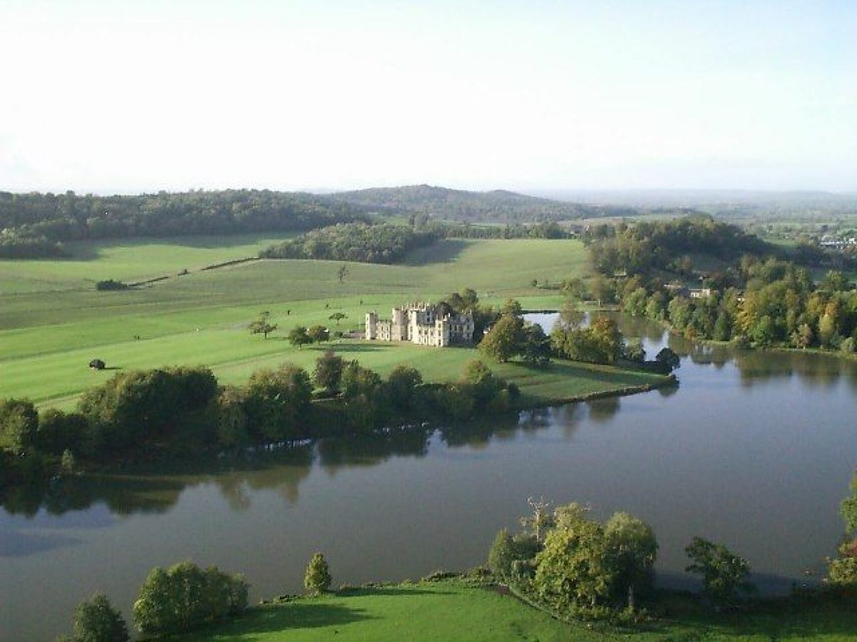
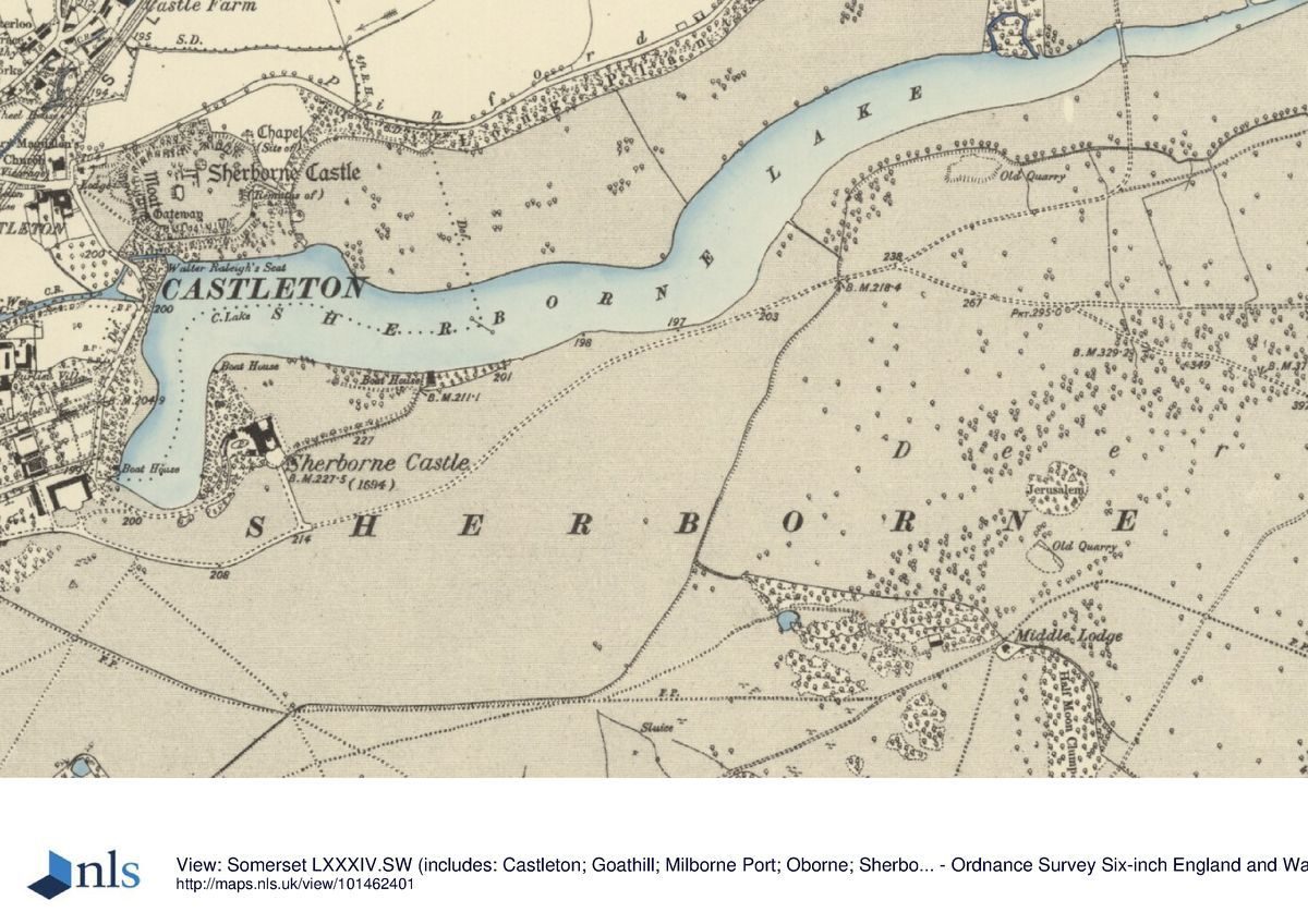
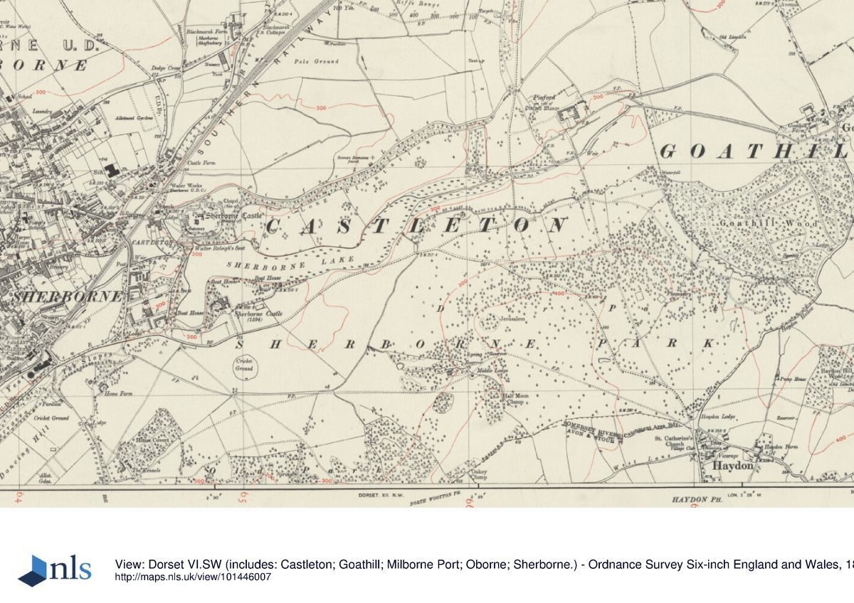
Sherborne Castle is situated immediately east of the town of Sherborne and south of the A30 road leading east from Sherborne to Shaftesbury. The c 440ha site comprises some 12ha of pleasure grounds around the Castle and the ruins of the old castle, a c20ha lake and c 408ha of parkland and ornamental plantations.
To the south the site adjoins agricultural land, while to the east and south-east it is bounded by a minor road leading from Haydon to Goathill, from which it is separated by a stone wall. To the north-east the site adjoins further agricultural land and the A30 road at Crackmore, while the northern boundary is formed by a stone wall separating the site from a minor road or track, Pinford Lane. Domestic properties in Castleton adjoin the site to the north-west, while a track, the remains of the old road to Dorchester diverted by Sir Walter Raleigh c 1595, is separated from the site by high stone walls. The western boundary is formed by New Road, a further diversion of the Dorchester road made in 1859 by George Wingfield-Digby, and to the south-west the site adjoins agricultural land and municipal playing fields on Dancing Hill.
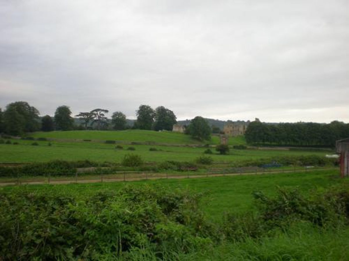
The site is undulating, with the River Yeo flowing from east to west through the site and forming the lake north of the Castle. The ground rises steeply to the north of the lake with the ruins of the medieval castle standing on a conical eminence. South of the Castle a ridge of high ground extends parallel to the southern boundary of the site, rising to Haydon Hill and Jerusalem Hill south-east of the Castle, and Gainsborough Hill to the south-west. To the north-east of the lake the ground rises towards the Crackmore entrance, with the drive affording extensive views across the lake and park. There are significant designed views from the various drives to the park and its surrounding landscape, and from viewpoints on Jerusalem Hill.
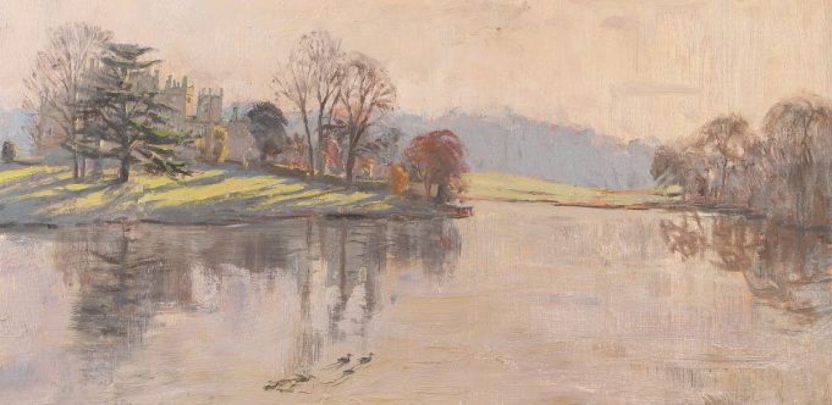
The lake, Castle and ruins form the focal points of vistas within the site, while beyond the boundaries of the site, Sherborne Abbey to the west-north-west serves as an eye-catcher.
Entrances and Approaches
In the early C2l, the principal approach to Sherborne Castle is from New Road to the west at a point c 300m east-north-east of the junction of New Road and South Street. The entrance is marked by a gateway comprising wrought-iron carriage gates supported by a pair of ashlar piers surmounted by Portland stone griffins, each holding the Digby coat of arms. The carriage gate is flanked by a pair of pedestrian gates supported by further, similar piers, which are in tum adjoined by a rubble stone wall to the south and by a low stone quadrant wall supporting railings to the north (all listed Grade II).
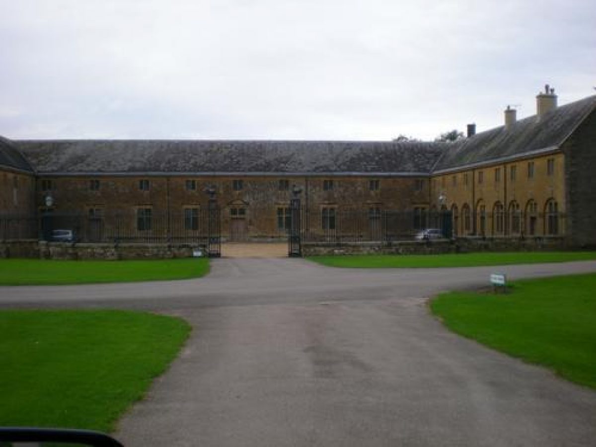
Immediately north-east of the entrance stands a two-storey stone lodge in Tudor-Gothic style (listed Grade II). The entrance gates, railings and lodge were constructed for George Wingfield-Digby by P C Hardwick in 1859. As part of this scheme, New Road was laid out, diverting the old road to Dorchester, c 190m west of its original course. Within the entrance a tarmac drive leads c 190m east-north-east to reach a junction immediately south of the mid C 18 stables (listed Grade II*) which stand c 300m west-south-west of the Castle. The stables and coach houses were built on this site by Henry Digby in 1759, replacing earlier stables which stood to the east of the Castle, and which were removed in order to open easterly views across the park (HLM).
From the junction in the drive, which is marked by a Turkish field gun captured at Abu Shusheh in 1917 (inscription), one branch leads east and north-east around the southern end of the lake to reach the forecourt below the south facade of the Castle. Another branch leads sweeps south-east and east through the park to reach a further junction c 100m south-south-east of the Castle with the east drives. From this junction a drive leads north-north-west through an open lawn to reach the forecourt.
The southern entrance to the forecourt is marked by simple cast-iron gates supported by low stone piers surmounted by carved griffins. The forecourt is enclosed from the park by low stone walls surmounted by simple horizontal metal railings. The forecourt and drives to the south and west of the Castle assumed their present form c1859 when a drive extending parallel to the southern boundary of the forecourt was diverted further south, perhaps with the advice of Broderick Thomas (HLM).
Further drives approach the site from the north-east, east and south-east. The north-east or Crackmore Drive enters the site from the A30 road at a point c 1km south-west of Milborne Port. The entrance is marked by a pair of late-C18 or early-C19 single storey stone lodges (listed Grade II) which flank a pair of stone piers supporting wrought-iron carriage gates (listed Grade II). Beyond the entrance the tarmac drive leads c 450m south-west through Crackmore Wood, a mixed plantation under-planted with box, before turning south-south-west for c 800m. The drive continues through a narrow belt of plantation with agricultural land to the east and south-east, across which views extend to Jerusalem Hill and Haydon Hill in the deer park.
The drive passes between a pair of stone piers surmounted by fleur-de-lys finials (1767, listed Grade II). From here it continues c 370m south, passing to the west of Pinford Farm, which was remodelled in the late C18 as a model farm (granary listed Grade II), to cross the eastern end of the lake on Pinford Bridge (listed Grade II*). The bridge, constructed in 1767 -70 to the design of Capt Robert Digby (CL, 1995), comprises three segmental arches beneath a balustraded parapet. Beyond the bridge, the drive sweeps westwards through the park, extending parallel to the lake and pleasure grounds east of the castle, to reach the forecourt below the south facade.
The section of the north-east drive between the Crackmore Gate and the Castle was constructed by Henry Digby in 1767-70 to create a new, principal approach to the Castle. The drive offers a series of carefully contrived views of the Castle, lake and deer park. The drive to the north of the Crackmore Gate was constructed in c1792 following the purchase of the Crackmore estate. The eastern drive is an extension of the north-east drive, leaving that approach at a point c 190m south of Pin ford Bridge. The east drive continues for c 350m eastwards through the park, before entering Goathill Wood and continuing to Goathill Lodge, a mid-C19 thatched cottage ornee (listed Grade II). The east drive appears to have formed part of the mid C19 improvements undertaken by George Wingfield Digby, although the Goathill estate had been purchased in 1781.
Some 800m south-west of Pin ford Bridge a further drive diverts south-eastwards from the eastern approach. Ascending the north-eastern slope of Jerusalem Hill, the drive extends c1km south-eastwards, passing to the south-west of the late C18 Keeper's Cottage (listed Grade II) to reach the mid C19 Haydon Lodge which stands adjacent to mid-C19 wrought-iron gates and flanking railings. Some 400m north-west of Haydon Lodge, a spur leads west-north-west from the south-east drive, passing along the crest and southern flank of Jerusalem Hill. Passing the mid-C19 Middle Lodge, a single storey, thatched cottage ornee the drive continues westwards for c1km before sweeping north-west to join the western approach c 300m south-west of the Castle. This drive appears to have been constructed in 1778 (HLM).
Principal Building
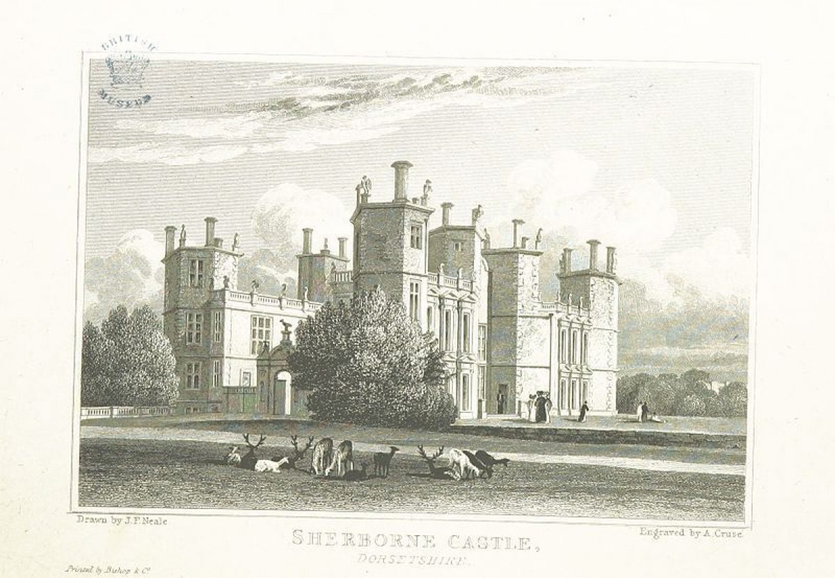
Sherborne Castle (listed Grade I), stands on an artificially-levelled terrace overlooking the lake towards the western boundary of the site. The two and three-storey building is constructed in rendered rubble stone with ashlar dressings under lead roofs set behind balustrades.
The Castle comprises a three-storey rectangular central block with corner turrets, from which extend two-storey wings which terminate in three-storey octagonal-plan towers. The building is lit by stone mullion and transom windows, while the corners are articulated by ashlar quoins and the storeys by ashlar string courses. Tall ashlar chimney stacks rise above the roofs. To the south a balustrade screen- wall encloses the stone-flagged forecourt between the south-east and southwest wings. The court is entered through an arched gateway flanked by piers under ogee caps. A similar screen wall and gateway encloses a similar flagged court to the north of the castle.
The central block and its comer turrets corresponds to the lodge built by Sir Walter Raleigh in the late C16 on the site of the medieval episcopal hunting lodge, while the four wings and octagonal towers are additions made by Sir John Digby in 1625. The Castle was altered in the C17 and C18, while in the mid C19 an extensive programme of restoration was undertaken under the supervision of P C Hardwick.
The ruins of the medieval Sherborne Castle (scheduled and listed Grade I) stand c 400m north of the present Castle, to the north of the lake. The standing elements of the Castle include sections of the curtain walls, the south-west gate tower together with the keep and associated buildings. Other elements of the Castle survive as archaeological remains exposed through excavation. The Castle was originally constructed in the early C12 by Roger, Bishop of Salisbury. It was restored in the late C16 by Sir Walter Raleigh, but was rendered uninhabitable in 1645 during the Civil War.
Gardens and Pleasure Grounds
Informal gardens and pleasure grounds are situated to the east, north and west of the Castle, and extend along the southern, western and north-western banks of the lake.
A level lawn extends c 250m eastwards from the Castle. To the south, the lawn is retained by a stone-walled ha-ha which allows views across the park towards the southern boundary plantations and south-east towards Jerusalem Hill. A gravel walk leads eastwards from the forecourt, parallel to the ha-ha, to reach a C20 stone bridge which crosses the ha-ha to allow access to walks within the shrubbery to the east of the lawn. Here, a late C20 stone and thatch rustic summerhouse enjoys southerly views across the park.
A further gravel walk extends along the northern-eastern side of the lawn, allowing views across the lake north-east towards Pinford Bridge, and north-west towards the ruins of the episcopal castle. The eastern end of the lawn is partly enclosed by mixed shrubbery. The east lawn assumed its present form between 1765 when an early C17 walled garden below the east facade of the Castle and the stables were removed, and 1776 when Brown constructed the ha-ha and levelled the lawn (HLM).
The walled garden, known as the Parlour Garden, was constructed in the C17 or early C18, and is shown on an estate survey of 1733 and in a painting of 1743, at which time it was laid out with four grass plots, perhaps replacing earlier parterres (HLM). The south-eastern and north-eastern corners of the Parlour garden were marked by octagonal pavilions echoing Digby's Castle towers; these were also removed in 1765.
To the north of the Castle lawns descend to the lake allowing reciprocal views to the castle ruins and the pleasure grounds north of the lake. This vista is framed to the east and west by specimen trees and evergreen shrubbery which enclose the lawn. Traces of a series of early-C18 terraces survive in this sloping lawn to the north-east of the Castle. Constructed by William, 5th Lord Digby as part of extensive formal gardens in the valley north of the Castle, the terraces were noted by Alexander Pope in 1724, at which time they were planted with clipped yews and honeysuckles. Pope's account refers to an axial avenue to the north of the Castle with a 'little triangular wilderness' of cherries and honeysuckles to the east.
The level ground in the floor of the valley, now covered by the mid C18 lake, was laid out with a bowling green flanked by rectangular groves of horse chestnuts. The stream was canalised and the south-facing slope below the mediaeval castle ruins was described as an amphitheatre with further terraced walks (HLM). The formal gardens, which appear to have appropriated the mediaeval ruins, are shown on the estate survey of 1733, and may have incorporated elements of late-C16 gardens developed by Sir Walter Raleigh. The terraces to the north-east of the Castle were levelled in 1765 when the Parlour Garden was removed (HLM).
A gravel terrace extends below the east and north facades of the Castle, connecting with a walk which descends north-north-west to provide access to the Orangery Garden north-west of the Castle. Here, a roughly elliptical shaped lawn with a central mature specimen tree is enclosed by a gravel walk. To the east sloping grass banks and ornamental shrubbery enclose the garden from the north lawn, while to the west a clipped hedge allows views across the lake. To the north, the garden is overlooked by the Orangery, originally known as the Greenhouse (listed Grade II*), designed in 1779, perhaps by Henry Holland (HLM).
North of the Orangery, a level terrace was created in the late C20 for public events adjacent to the restored late-C19 timber boathouse. To the south, the Orangery Garden is overlooked by the gothic Dairy (listed Grade II*), which was constructed in 1753-55, perhaps to the design of Brown. The Dairy contains a re-set Roman mosaic pavement from Lenthay Common. The Orangery Garden was formed by Brown from 1776, while a plan of 1796 shows the area laid out with a series of flower beds divided by narrow paths; this appears to correspond to Lady Digby's Flower Garden (HLM).
A wrought-iron gate to the east of the Dairy leads from the Orangery Garden to the service court immediately west of the Castle. The central area of the court is today laid out with an approximately elliptical area of raised lawn with central and peripheral flower beds. On the south side of the court, beneath a mature Ilex oak stands the raised timber game larder and the entrance to the mid-C18 ice house. A tunnel leads west beneath the late-C18 brick wall which forms the western boundary of the court to provide access to further service buildings which, in the C18, stood between the court and the lake. The service area was remodelled and improved by Brown in c1776 (HLM).
A walk leads south-west from the Orangery Garden, passing through an area of ornamental shrubbery and trees parallel to the south-east shore of the lake. Passing through a metal gate the walk enters the park and joins the western drive which extends parallel to the southern end of the lake. At the south-west comer of the lake a further metal gate affords access from the drive to the pleasure grounds on the western and northern banks of the water.
A serpentine gravel walk leads north for c 375m parallel to the western bank of the lake, through an area of lawns, shrubbery and specimen trees. To the west this area is enclosed by a stone wall which separates the pleasure grounds from a track, beyond which lies the kitchen garden. This track corresponds to the course of the public road to Dorchester stopped-up by George Wingfield Digby in the mid C19. The gravel walk turns north and north-west through an avenue of limes to reach Sir Walter Raleigh's Seat, a late-C16 raised stone terrace approached by a flight of steps and flanked by a pair of stone bench seats. The Seat is constructed against the wall separating the pleasure grounds from the former public road, allowing a view across both the road and eastwards across the lake which occupies the site of the early -C18 formal gardens.
Beyond Raleigh's Seat the walk continues north-west, crossing the outflow from the lake on a triple-arched medieval bridge which formerly served the public road. From the bridge and the walk on the northern side of the outflow there is a view of naturalistic rocky cascade which retains the lake; this is contemporary with the lake, and was constructed by Brown in 1753. To the north of the cascade and adjacent to the walk stands Pope's Seat, a stone-arched alcove surmounted by a crenellated parapet, which was constructed in the late C18, perhaps to the design of Henry Holland (HLM). The northern bank of the lake is planted with mature cedars and other specimen trees, together with groups of mature yews. The south-facing bank is terraced, perhaps a survival from the early C18 formal gardens.
Walks extend parallel with the lake shore and below a mid-C18 crenellated stone wall which surmounts the slope. The lower walk passes a ruined turret and section of stone wall c 50m south-east of the Castle; this was constructed in 1755 by Daniel Penny as a picturesque feature to enhance the effect of the castle ruins. The yews adjacent to the turret form part of the same picturesque scheme, as did the ivy which formerly mantled the medieval ruins (HLM). Beyond the ruined turret the walk turns north-north-east passing across a drive that leads over a late-C18 stone arched bridge to the medieval castle on. To the south-west of the bridge a wrought-iron clair-voir set in the castle wall allows a reciprocal view of the ruins and the park, which is here separated from the pleasure grounds by a ha-ha. Turning east, the walk extends for c 170m through a belt of mature trees and shrubbery which screens Pinford lane on the northern boundary of the site, to reach a C19 metal gate flanked by stone piers. This gate leads to a continuation of the walk passing through Long Plantation on the northern boundary of the park providing an approach to Pinford Farm.
Park
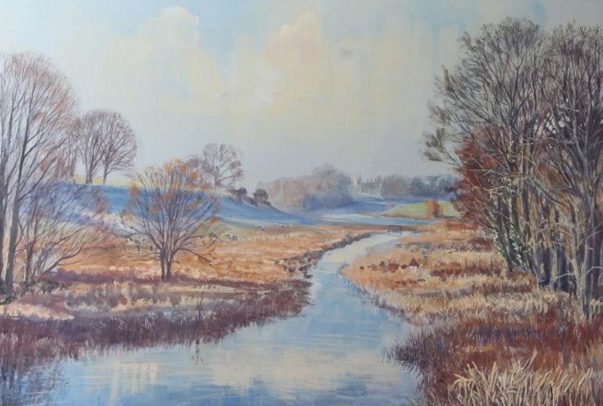
The park lies to the south and east of the present Castle, with a further area situated to the north of the eastern arm of the mid-C18 lake. The park is udulating, rising to the north and south, with a prominent area of high ground, Jerusalem Hill, to the southeast. The River Yeo flows from east to west through the shallow valley to the north of the Castle. This was dammed by Brown in 1753 to create the lake which forms the focal point of the park landscape. The lake was extended in 1764 and 1770-71.
The park to the south of the Castle and west drive, known as Shooters Lawn or the Lawn, is in arable cultivation, having been converted from pasture during the Second World War. The north-facing slopes beyond this area, known as Old Park, remain wooded. A C20 vista aligned on the south facade of the Castle has been cut through the woodland, replicating, although on a different alignment, an avenue shown on the 1733 estate survey; this feature had been lost by 1796 (estate plan). To the east and north-east, the park remains pasture with scattered trees and more dense woodland on the higher ground to the south-east. To the north the park boundary is screened by Long Plantation, while to the east the park is bounded by Goathill Wood.
A sunk fence and stone wall extends north and north-east from the south-east drive to separate the deer park to the south-east from the remainder of the park, known as Old Park and Shooters Lawn. The park wall appears to have been constructed by 1570, while the ha-ha or sunk fence was built in 1766-68 to confine the deer to the higher ground to the south-east and allowing uninterrupted views from the Castle across the park.
The water meadows associated with Pinford Farm are incorporated within the park to the east of Pinford Bridge. The meadows were created in 1763 and improved in 1771. During the late C18, Pinford was developed as a model farm within the expanded park.
A deer park associated with the episcopal castle existed in the early C12, and by the mid-C14 this contained fish ponds (Proceedings, 1965). The medieval park was enclosed by an earth pale, which by the late C16 was surmounted by a stone wall (map, 1570). The Tudor park was divided into four compartments, probably by fences; some of these areas correspond to those which survive today.
The site of the present Castle was occupied by a lodge, constructed in c1500. By the early C18, Ladd's map (1733) shows some trees and scrub on the higher ground to the south of the Castle, together with scattered trees on Jerusalem Hill and fenced plantations on Haydon Ball. The early park was remodelled from 1753 by Edward Digby and Henry Digby, in part with the advice of Lancelot Brown. Work on the park continued into the late C18 as new land was acquired and incorporated into the ornamental scheme at Goathill (1781) and Crackmore (1792). Further improvements were undertaken in the mid-C19 by George Wingfield Digby, who extended the park to the west by the construction of New Road, and built a series of lodges at the principal entrances to the park and Middle Lodge within the park.
Kitchen Garden
The kitchen garden is situated c 270m west of the Castle, to the north of the stables, and to the west of the track which represents the course of the old Dorchester road, and east of New Road which replaced it in 1859. The garden is enclosed by brick walls under stone coping, and is sub-divided by similar walls into four compartments.
The garden is now (2004) partly in use as a garden centre and nursery, with groups of late-C20 buildings associated with this use standing adjacent to the western wall of the garden. There are further late-C20 glasshouses and service structures within the two western compartments. The double-pile two-storey gardener's house remains towards the centre of the central compartment. This mid-C18 building is constructed in brick under stone slate roofs.
The kitchen garden was constructed in 1753-55, perhaps with the advice of Brown.
Reasons for Designation
Sherborne Castle, a mediaeval deer park and late C17 and early C18 formal gardens, remodelled in the mid-C18, is included on the Register of Parks and Gardens of Special Historic Interest at Grade I for the following principal reasons:
- Date and rarity: the site, though reflecting several phases of historic development of considerable significance, is an exceptionally interesting example of a mid-C18 landscape designed by Lancelot Brown, one of England's most important landscape designers which he created in the early part of his career;
- Intactness: the landscape by Brown survives essentially intact incorporating important evidence of earlier landscape phases;
- Documentation: the history of this complex, multi-phased landscape is particularly well documented;
- Group value: it has exceptionally strong group value with the Grade I listed Sherborne House and the scheduled ruins of Sherborne Old Castle, the latter, incorporated as a feature in the landscape design for Sherborne from the early C18 onwards, being an exceptionally important and interesting example of how ruins were used in landscape design during this period;
- Archaeological interest: archaeological traces of the medieval deer park and early-C18 garden are visible and significant above ground structures survive adding considerably to the exceptionally high level of interest of this designed landscape.
Selected Sources
Book Reference - Author: Stroud, Dorothy - Title: Capability Brown - Date: 1975 - Page References: 239
Book Reference - Author: Pevsner, N and Newman, J - Title: The Buildings of England: Dorset - Date: 1972 - Page References: 388-391 - Type:
Book Reference - Author: Oswald, Arthur - Title: Country Houses of Dorset - Date: 2nd edn 1959 - Page References: 130-135
Book Reference - Author: Hutchins, J - Title: History and Antiquities of the County of Dorset, vol iv - Date: 1870 (3rd edn) - Page References: 277-8
Article Reference - Date: 24 September 1910 - Journal Title: Country Life - Page References: 425-432
Article Reference - Date: vol 87, 1965 - Journal Title: Proceedings of the Dorset Natural History and Archaeological Society - Page References: 227
Article Reference - Date: no 22 (1975) - Journal Title: Notes and Queries - Page References: 490-491
Article Reference - Date: 1976 - Journal Title: Garden History - Volume: 4 no 1 - Page References: 57-87
Article Reference - Date: 1976 - Journal Title: Garden History - Volume: 4 no 3 - Page References: 5-8
Article Reference - Date: 1995 - Journal Title: Proceedings of the Dorset Natural History and Archaeological Society - Volume: 117 - Page References: 15-19
Article Reference - Date: 6 July 1995 - Journal Title: Country Life - Volume: 189 - Page References: 62-65
Article Reference - Date: Nov 1995 - Journal Title: The Local Historian - Page References: 231-241
Article Reference - Date: 2001 - Journal Title: Garden History - Volume: 29 no 1 - Page References: 64-81
Book Reference - Author: Mowl, Timothy - Title: Historic Gardens of Dorset - Date: 2003 - Page References: 84-87
Map Reference - Title: Map of Dorset - Date: 1570 - Source: Dorset Record Office
Map Reference - Title: Map of Sherborne Parish - Date: 1733 - Source: Sherborne Castle Archives
Other Reference - Description: Capt Robert Digby, Plans for Pinford Bridge, c1767 (Sherborne Castle Archive)
Other Reference - Description: A Rough PLan of Sherborne Park, 1769 (Sherborne Castle Archive)
Map Reference - Title: OS 6" to 1 mile - Date: 1st edn surveyed 1885, published 1889
Map Reference - Title: OS 25" to 1 mile - Date: 2nd edn revised 1901, published 1903
Other Reference - Description: Sherborne Castle Estate, Dorset Quinquennial Inspection Report by the Countryside Agency (17 January 2005)
Other Reference - Description: Sherborne Park, Sherborne, Dorset Heritage Management Plan (Feb 2006) grant aided by the Countryside Agency
Other Reference - Description: Sherborne and Lodge Parks - Park and Garden Survey (1990) by The National Trust
- Visitor Access, Directions & Contacts
Telephone
441935 813182Access contact details
The castle and grounds are open to the public every day except Mondays and Fridays between April and October. Please see: http://www.sherbornecastle.com...
The Old Castle is in the care of English Heritage, and is open daily from 10 am between April and October.
Directions
From the M3, M5 or A30, follow signs for Yeovil or Sherbourne.
- History
The following is from the Register of Parks and Gardens of Special Historic Interest. For the most up-to-date Register entry, please visit the The National Heritage List for England (NHLE):
www.historicengland.org.uk/lis...
History
In the early C12, Roger, Bishop of Salisbury (1107-39) built a castle at Sherborne to serve as the administrative centre for the western part of his diocese (HLM). A deer park associated with the castle contained, in addition to deer, fish ponds and pasture (HLM; Proceedings, 1965). During the reign of King Stephen, Sherborne Castle was acquired by the Crown, but in 1355 it reverted to the Bishops of Salisbury. In 1542, Henry VIII reorganised the English dioceses, placing Dorset in the newly created diocese of Bristol, and thus reducing Sherborne's strategic significance to the Bishops of Salisbury. A lease of the Castle, later converted to the freehold, was granted to Queen Elizabeth in 1592, and was subsequently made over to her favourite, Sir Walter Raleigh (1522-1618). Raleigh constructed a new house, known originally as Sherborne Lodge, on the site of the Bishop of Salisbury's early-C16 hunting lodge in the park south of the mediaeval castle. This house was completed by 1594, and formal gardens were laid out, perhaps to the design of Raleigh's half-brother, Adrian Gilbert, between it and the mediaeval castle. Following Raleigh's arrest on charges of treason in 1603, Sherborne reverted to the Crown. James I granted the Castle first to his favourite Robert Carr, and subsequently to his elder son, Prince Henry, who died in 1612. In 1617 the Crown sold the Sherborne estate to Sir John Digby, the ambassador to Spain, who in 1618 was created Baron Sherborne, and in 1622 Earl of Bristol. During the Civil War the mediaeval Castle was besieged by Parliamentary troops in 1642 and 1645. After the second siege, Thomas Fairfax slighted the Castle. The Earl went into exile in France, where he died in 1652. The third Earl of Bristol died without heirs in 1698, and the Sherborne estate passed to William, 5th Lord Digby of Coleshill, Warwickshire.
The 5th Lord Digby's son, Robert (1692-1726) created or remodelled the formal gardens to the north of the Lodge, known since the slighting of the old Castle as Sherborne Castle, and an enclosed formal garden, the Parlour Garden, to the east of the Castle. Alexander Pope (1688-1744), a friend of Robert Digby, visited Sherborne in 1724, leaving a description of the formal gardens in his correspondence (Garden History, 1976). The early-C18 disposition of the gardens around the Castle and the ruins is shown on a plan made by John Ladd in1733 (private collection). William, 5th Lord Digby died in 1752 and was succeeded by his grandson, Edward, who in 1753 called in Lancelot Brown (1716-83) to create a lake in the valley between the Castle and the ruins. It is possible that Lord Digby had been introduced to Brown in Warwickshire, where the latter had already worked for the Digbys' neighbour, Lord Guernsey at Packington Hall (1750) (qv), and Lord Brooke at Warwick Castle (1749) (qv). Brown also worked for the Earl of Denbigh (father-in-law to Lord Digby's brother and heir, Henry), at Newnham Paddox, Warwickshire (1741) (qv). Estate accounts detail the work undertaken under Brown's supervision, including the removal of the formal gardens, the creation of the lake and its gradual extension upstream east of the Castle, and the opening of the vista between the new Castle and the ruins north of the lake. The ruins themselves were enhanced as a picturesque object by Daniel Penny, who in 1755-6 added crenellation to walls and constructed a ruined tower.
The improvement of the landscape continued after the death of Edward, Lord Digby in 1757, and after the succession of his brother Henry, who was created Earl Digby in 1790. New stables were built west of the Castle in 1759, and in 1776 Brown was recalled to Sherborne to improve the area immediately around the house, creating the east lawn and constructing the ha-ha separating the pleasure grounds from the park. Pinford Farm was reconstructed as a model farm in the late C18, and a new approach, crossing the lake on a bridge designed by Capt Robert Digby, was laid out in 1767-71. In 1780 a greenhouse and an 'alcove in the grove', probably Pope's Seat, were constructed, perhaps to the design of Henry Holland (1746-1806) (HLM). Towards the end of Earl Digby's life, a new entrance to the ruins was formed, together with a clairvoir allowing a vista from the ruins across the park. The park itself was significantly extended through land purchases in 1781 and 1792. The first Earl Digby died in 1793 and was succeeded as second Earl by his son, who made few changed to the Sherborne estate and died unmarried in 1856. The estate devolved on the second Earl's nephew, George Wingfield, who adopted the name Digby, while the Barony passed to Edward Digby of Minterne, Dorset (qv). George Wingfield Digby commissioned P C Hardwick (1822-92) to restore the Castle, and construct new lodges in the park, while William Broderick Thomas (1811-98) advised on the rearrangement of the southern approach to the Castle (HLM).
The park remained substantially unchanged throughout the late C19 and early C20. The ruins of the old Castle were placed in the guardianship of the Ministry of Works in 1950, and are now (2013) in the guardianship of English Heritage. Sherborne Castle was inherited in 1952 by Simon Wingfield Digby, who undertook an extensive programme of repairs and restoration. In 1998 his son inherited the estate.
Period
18th Century (1701 to 1800)
- Associated People
- Features & Designations
Designations
The National Heritage List for England: Register of Parks and Gardens
- Reference: GD1422
- Grade: II*
Features
- Castle (featured building)
- Description: The castle was built by Sir Walter Raleigh.
- Earliest Date:
- Specimen Tree
- Description: There are fine mature trees in the parkland.
- Lake
- Earliest Date:
- River
- Description: The river Yeo flows from east-north-east to west-south-west.
- Deer Park
- Parkland
- Key Information
Type
Park
Purpose
Ornamental
Principal Building
Domestic / Residential
Period
18th Century (1701 to 1800)
Survival
Extant
Hectares
420
Open to the public
Yes
Civil Parish
Sherborne
- References
References
- Stroud, D {Capability Brown} (1975) pp 206, 239 Capability Brown (Country Life article)
- Newman, J and Pevsner, N {The Buildings of England: Dorset} (Harmondsworth: Penguin, 1972) pp 385-391 The Buildings of England: Dorset
- Oswald, A {Country Houses of Dorset} (1959) pp 130-135, pls 143-145 Country Houses of Dorset
- {English Heritage Register of Parks and Gardens of Special Historic Interest} (Swindon: English Heritage 2008) [on CD-ROM] Historic England Register of Parks and Gardens of Special Historic Interest
- Historic Land Management {Sherborne Park Heritage Management Plan} (2006) Sherborne Park Heritage Management Plan