Introduction
Rousham has a landscape park which includes gardens, pleasure grounds and a walled kitchen garden.
Terrain
The park covers largely level ground above the Cherwell flood plain, with the pleasure grounds running down the hillside.www.historicengland.org.uk/listing/the-list
NOTE
This entry is a summary. Because of the complexity of this site, the standard Register entry format would convey neither an adequate description nor a satisfactory account of the development of the landscape. The user is advised to consult the references given below for more detailed accounts. Many Listed Buildings exist within the site, not all of which have been here referred to. Descriptions of these are to be found in the List of Buildings of Special Architectural or Historic Interest produced by the Department of Culture, Media and Sport.
Rousham is a 17th-century country house with pleasure grounds laid out to designs by Charles Bridgeman during the 1720s, landscaped, modified and extended by William Kent from 1737-41, and of great contemporary influence. The site is the most complete surviving example of Kent's landscape work.
SUMMARY DESCRIPTION
Rousham lies in north Oxfordshire, 1km south of the village of Steeple Aston, 1km south-west of Lower Heyford and 2km south-west of Upper Heyford. The c 55ha site is bounded largely by agricultural land, with the lane to Steeple Aston cutting north/south through the park. The north boundary is formed by the B4030 road from Middleton Stoney to Enstone, and the south boundary is marked by a stone wall. The park covers largely level ground above the Cherwell flood plain, with the pleasure grounds running down the hillside to a riverside walk and the adjacent water meadow beyond the River Cherwell.
The largely rural setting is very important, especially in views north and east from the house, garden and pleasure grounds. Kent intended extensive views across the flood meadows north of the Cherwell, and farmland beyond, to local villages, in particular the church towers and villages of Steeple Aston, Upper and Lower Heyford and Rousham itself, together with the medieval, causewayed Heyford Bridge standing 500m north of the house. The taller buildings of Upper Heyford Airfield are visible on the skyline 2.5km north-west of the site, together with several groups of C20 agricultural buildings, and intrusive late C20 developments on the edges of the villages. A development in Steeple Aston obscures the intended view of the church tower. A rim of low, partly wooded hills, 2km distant, terminates views south from the house and park across agricultural land, with a prominent clump of trees standing on the hillside 1.5km south of the house.
The main approach runs south along the lane from Steeple Aston, past the west end of the stone-built Heyford Bridge (C13 and later, listed grade II*), then runs through parkland, partly bounded to the east by the stone boundary wall of the park and pleasure grounds (mid C18, listed grade II). A stone, Palladian gateway with a wooden door (Kent 1730s, restored 1990s, listed grade II*), stands 270m north-west of the house, flanked by the wall, and formerly gave visitors direct access to the pleasure grounds at their south-western extremity. Close to the gateway stands a two-storey, castellated stone lodge (Kent 1730s, listed grade II*), with on the north front an open archway enclosing an alcove with a wooden seat overlooking the park and gateway, and on the south front an open archway to a cow house, directly accessible from the park and visible from the lane through an iron clairvoie in the park wall.
The lane leads south, flanked by parkland, to the entrance to the main drive lying 270m south-west of the house, with a single-storey, stone lodge (1840, listed grade II) on the north side of the entrance. The entrance is flanked by stone gate piers with ball finials, supporting iron gates, flanked by screen walls. From here the lane continues 1.5km south to join the main Oxford to Banbury road. The drive runs east through the park, flanked by a lime avenue, crossing the main avenue from the house across the south park, then curving north, with views east along the main village street, crossing the stable yard (stables c 1738, probably Kent, listed grade II*), to the south front of the house. Here a turning circle surrounding a central lawn is joined by a spur (disused) leaving the main drive 1.7km south-west of the house. A set of broad stone steps leads up to the house, with views south along the early C20 avenue to the distant hillside, and overlooking the ha-ha to the park to the west.
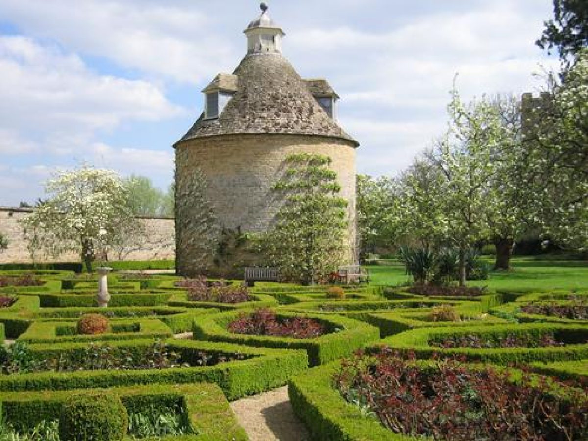
The site consists of gardens, pleasure grounds and parkland, with outlying features to the north and east. Rousham House (1630s, remodelled Kent 1730s, listed grade I) lies towards the centre of the site, at the south boundary of the garden and pleasure grounds. A formal terrace and bowling green (1720s), encircled by a gravel path, lying adjacent to the north front, is bounded to the west by an early ha-ha (1730s, listed grade II), giving views of the park on both sides of the Steeple Aston lane. To the east of the bowling green stands the main stone-walled, 0.5ha kitchen garden, now largely laid to lawn with fruit trees lining the walks and an herbaceous border along the south wall (the walls late C17-C19, listed grade II*). South of this a further walled enclosure contains a circular dovecote (C17, listed grade II*) set in lawn, and a formal rose garden to the west of this. A smaller walled garden, still cultivated, lies east of the main kitchen garden, with an orchard to the east. These gardens lie close to, and are overlooked by, Rousham church.
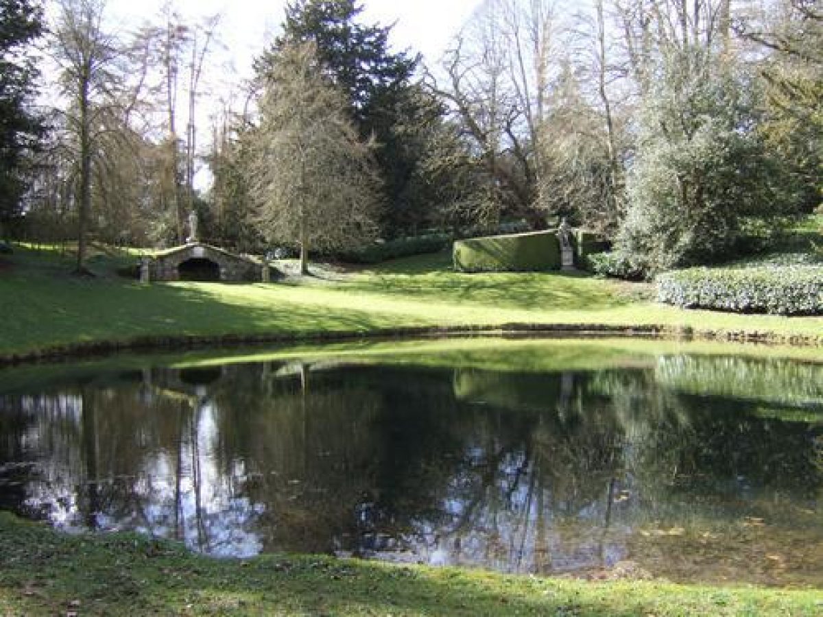
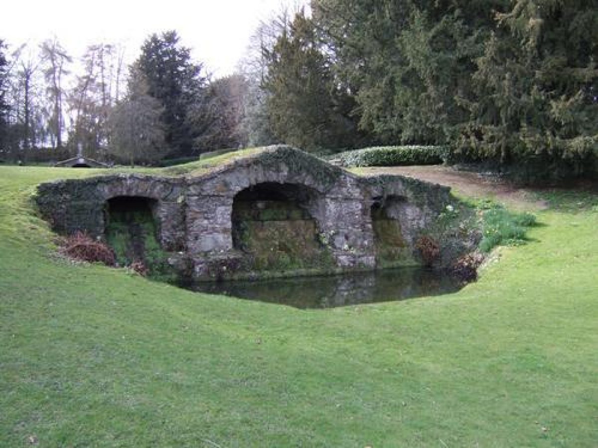
North of the bowling green a steep, concave grass slope leads down to the riverside and beyond this the meadow leading to the B4030, with extensive views north over the countryside, particularly to the Temple of the Mill (formerly called Cuttle mill, late C17, altered Kent 1730s, listed grade II*) standing 1.1km north of the house adjacent to the river, and on the hillside above this, c 2km north of the house, the stone, triple-arched Eyecatcher (Kent c 1740, listed grade II*). This sham castle gateway, 9m high and 21m long, was designed to stand on the skyline, but is now somewhat obscured by woodland trees behind it to the north. These buildings are two of the earliest examples of picturesque eyecatchers, placed by Kent on land not initially owned by the Dormers in order to draw the eye into the landscape.
At the north-west corner of the bowling green a path leads into the informal pleasure grounds on the hillside leading down to the river. The area consists of a series of picturesque circuit walks within woodland, with planned surprise incidents and views into the surrounding countryside. The principal circuit, entering at the Palladian doorway in the garden wall and walking north-east, is described by John Macclary, the Dormer's gardener, in a letter of 1750 to his employers, reproduced in Garden History 11 (1983). It is largely possible (1998) to follow this circuit and obtain the effects which Macclary identifies.
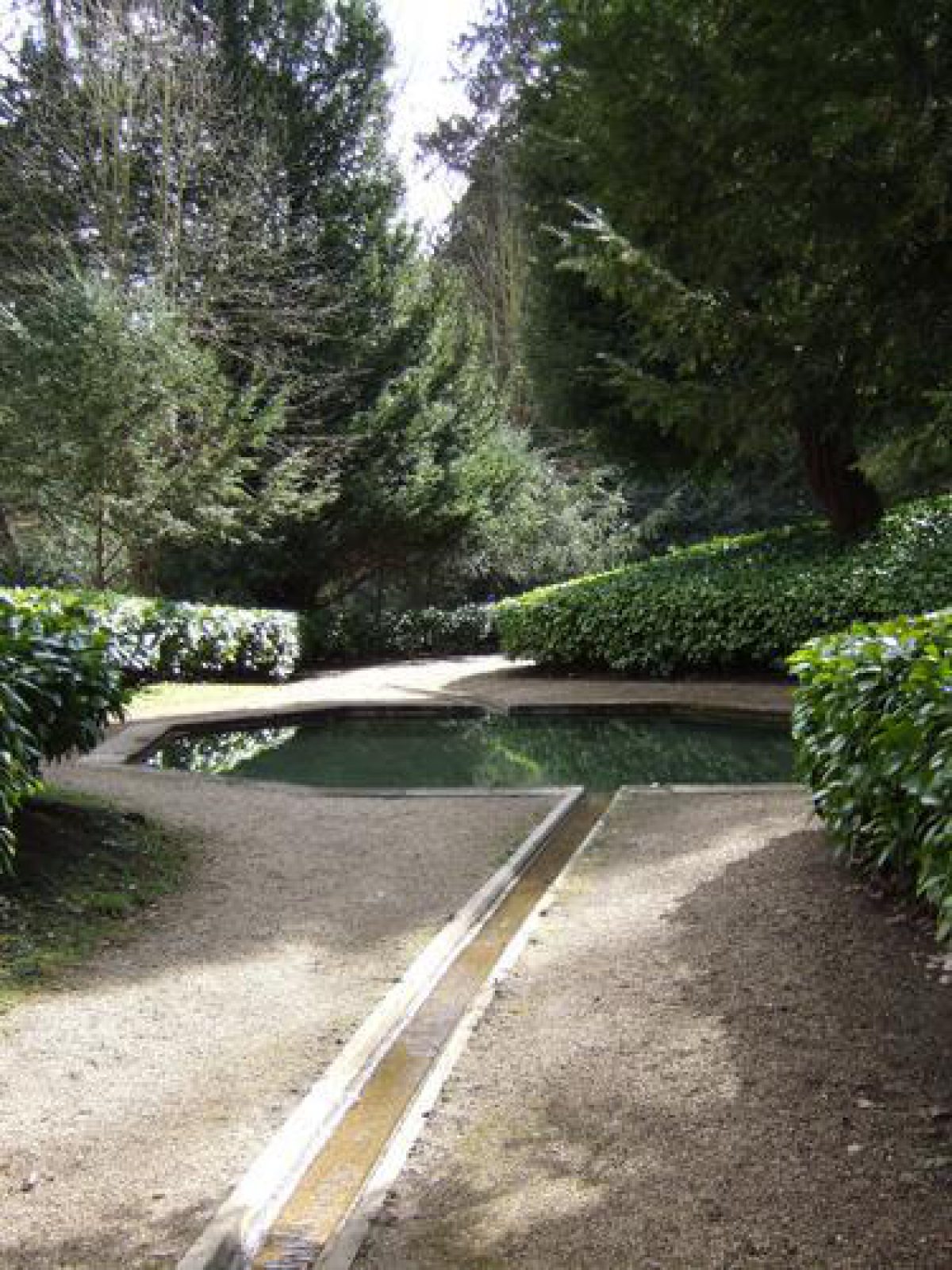
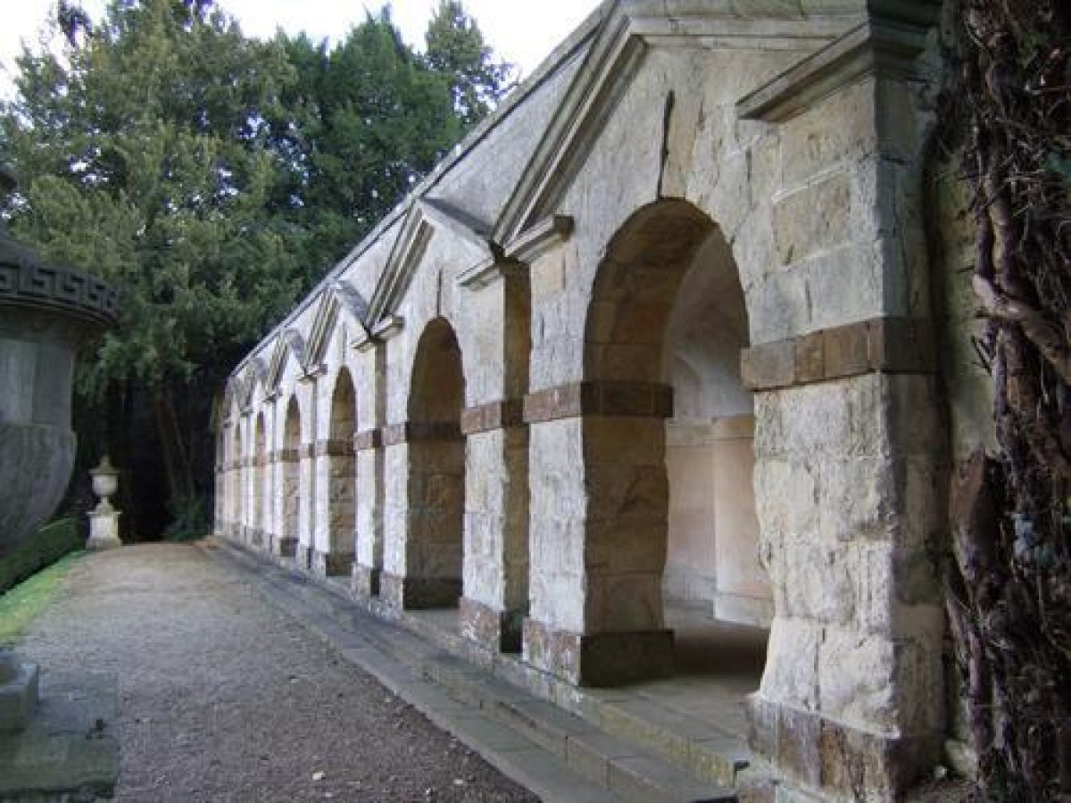
Kent used features, both already extant and those he deliberately sited, to draw the eye out from the relatively small (6ha) pleasure grounds, realising the pictorial qualities of the landscape. His features include a rill extending north along the Watery Walk with a cold bath and adjacent grotto (Kent 1738(40, listed grade II*), leading to the Temple of Echo, or Townesend's Building (Kent and Wm Townesend 1738-40, listed grade II*), a rustic Doric temple. From here the visitor returns south on the Macclary circuit, to the bottom of Venus Vale, intended as a surprise climax, having made the circuit walk to this point with views out. Here the eye is deliberately turned inwards to the Vale rising westwards from the river. The visitor, standing at river level, sees two cascades, these actually standing above and below an octagonal pond hidden at this point by the rising ground. The cascades are seen to run down the hill adjacent to each other, in a trompe l'oeil effect, the pond separating them acting as a reservoir for the fountains in it. From here a path leads up to the arcaded garden loggia, Praeneste (Kent 1738-40, listed grade II*), set into the north-facing hillside. From nearly all these features views extend north or east across the river and adjacent meadow into the surrounding countryside; many views, now closed by vegetation, were intended to take in the Mill and Eyecatcher.
East of Praeneste the riverside walk continues south-east, below Bridgeman's former theatre, set into the hillside, past Kent's slope below the bowling green, to the open grassy lawn up to the Pyramid House gazebo (Kent 1733-40, listed grade II*), and beyond this through woodland up to a doorway into the small walled garden east of the main kitchen garden. Two clumps, the North and South Roundels, possibly sited by Kent, stand on the skyline 900m east of the house, visible from various parts of the pleasure grounds on an otherwise bare hillside.
The park contains many park trees, in clumps and singles, and is laid to pasture, with Park Farm standing in the west half. The enclosed area west of the house is important in views from the house and bowling green and from the perimeter walk above the ha-ha along the south side of the pleasure grounds, running north and west to the gateway off the lane. From the gateway a long view extends south-east across the park to the house and beyond to the church tower and distant South Roundel.
REFERENCES
Note: There is a wealth of material about this site. Some key references are cited below.
Country Life, 27 (26 February 1910), pp 306-15; 99 (17 May 1946), pp 900-3; (24 May 1946), pp 946-9; (14 June 1946), pp 1084-7; (21 June 1946), pp 1130-3
N Pevsner and J Sherwood, The Buildings of England: Oxfordshire (1974), pp 740-6
P Willis, Charles Bridgeman (1979), pp 66-8
M Batey, Oxford Gardens (1982), pp 104-6
Victoria History of the County of Oxfordshire 11, (1983), pp 159-63
Garden History 11, no 2 (1983), pp 126-32; 25, no 2 (1997), pp 178-88
J Garden History 6, no 3 (1986), pp 187-226
Maps
A Jones (CPRE), Rousham Landscaped Gardens, 1980 (copy on EH file)
Map of the Parish of Rousham, 1721 (Oxfordshire County Record Office)
OS 6" to 1 mile: 1st edition published 1875; 2nd edition published 1898
OS 25" to 1 mile: 1st edition published 1881; 2nd edition published 1899
Description written: March 1998
Amended: March 1999
Edited: March 2000
- Visitor Access, Directions & Contacts
Telephone
01869 347110Website
http://rousham.orgAccess contact details
The gardens are open daily from 10 am. The house is only open by prior arrangement. Please see: http://www.rousham.org/visit
Directions
12 miles north of Oxford, off A4260.
- History
The following is from the Register of Parks and Gardens of Special Historic Interest. For the most up-to-date Register entry, please visit the The National Heritage List for England (NHLE):
www.historicengland.org.uk/listing/the-list
HISTORIC DEVELOPMENT
Sir Robert Dormer bought Rousham Manor in 1635, building a new manor house soon after. The earliest gardens included a formal one to the north and a walled garden with a dovecote to the east (extant 1998). In 1677 the formal garden contained five terraced walks, one below the other, leading down to the River Cherwell. By 1721 a 'new garden' was made along the river north-west of the house, laid out as a wilderness with ponds, straight walks and a temple or pavilion. A plan of around 1725, probably by Charles Bridgeman (died 1738), shows a complete reorganisation and extension of the garden, but it is not known how much of this was carried out (Victoria County History). Workmen were employed in the gardens between 1725 and 1734. In 1728 Alexander Pope thought the gardens 'the prettiest place for waterfalls, jets, ponds, inclosed with beautiful scenes of green and hanging wood, that I ever saw' (Willis 1979). William Kent (1685-1748) was employed by James Dormer between 1737 and 1741, enlarging and remodelling the house, park and pleasure grounds. He reused much of the extant garden structure, but softened the lines and introduced additional features and circuit walks using the countryside beyond to provide extensive picturesque views. The detailed planning and planting were carried out by the steward William White and the gardener John MacClary. The pleasure grounds were very influential during the 18th century, being commented upon by many visitors, including Horace Walpole who thought it his favourite William Kent garden (Batey 1982). Little further work was carried out on the gardens, leaving them largely untouched to the present (1998). The site remains in private ownership.
- Associated People
- Features & Designations
Designations
The National Heritage List for England: Register of Parks and Gardens
- Reference: GD1000
- Grade: I
Style
English Landscape Garden
Features
- Ornamental Lake
- Ornamental Pond
- Description: Octagonal shaped
- Cascade
- Description: Two cascades
- Ornamental Bridge
- Folly
- Temple
- Dovecote
- Parterre
- Lawn
- Bowling Green
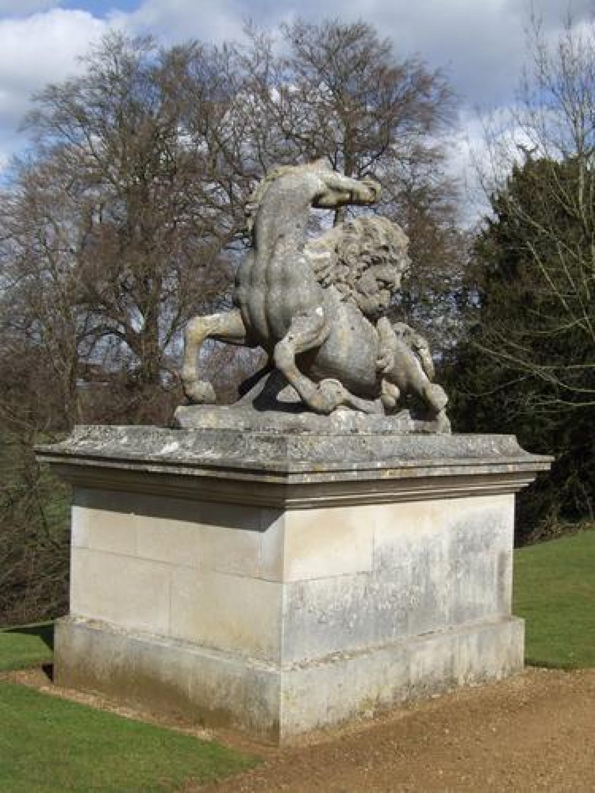
- Sculpture
- Rill
- Kitchen Garden
- Manor House (featured building)
- Description: The 17th-century house was enlarged and re-modelled by William Kent from 1737 to 1741.
- Earliest Date:
- Latest Date:
- Grotto
- River
- Cold Bath
- Fountain
- Key Information
Type
Garden
Purpose
Recreational/sport
Principal Building
Domestic / Residential
Survival
Extant
Hectares
55
Open to the public
Yes
Civil Parish
Rousham
- References
References
- {English Heritage Register of Parks and Gardens of Special Historic Interest}, (Swindon: English Heritage, 2008) [on CD-ROM] Historic England Register of Parks and Gardens of Special Historic Interest
- Pevsner, N. and J. Sherwood, {The Buildings of England: Oxfordshire} (Harmondsworth: Penguin, 1974), pp. 740-6 The Buildings of England: Oxfordshire
- Batey, M., {Oxford Gardens} (Amersham: Avebury, 1982), pp. 66-8 Oxford Gardens: The University's Influence on Garden History
- Crossley, Alan {Victoria County History: Oxford, Volume 11} (London: Oxford University Press, 1983) 159-63 Victoria County History: Oxford, Volume 11
- Related Documents
-
CLS 1/239/1
The Garden at Rousham - A Conservation Plan - Hard copy
Colvin & Moggridge - undated 1983?
-
CLS 1/276/1
Conservation Plan - Digital copy
Colvin and Moggridge - 1983
-
CLS 1/239/1