Introduction
The estate at Ditchley originates in the medieval period. The present house was constructed in 1722. The gardens and pleasure grounds occupy about 40 hectares within a park of about 140 hectares.
Terrain
The site lies on undulating land at the eastern edge of the Cotswold hills in a rural setting.The following is from the Register of Parks and Gardens of Special Historic Interest. For the most up-to-date Register entry, please visit the The National Heritage List for England (NHLE):
www.historicengland.org.uk/listing/the-list
An early C18 country house with C18 landscape park and remains of an early C18 formal layout. Informal pleasure grounds laid out by John Claudius Loudon 1805-10, and formal gardens by Geoffrey Jellicoe 1930s.
DESCRIPTION
LOCATION, AREA, BOUNDARIES, LANDFORM, SETTING
Ditchley Park lies c 16km north-west of Oxford, 2km north-east of Charlbury, within the confines of the medieval Royal Forest of Wychwood. The c 180ha park, bounded by agricultural land and woodland, lies on undulating land at the eastern edge of the Cotswold hills in a rural setting. An important part of this setting lies immediately adjacent to the north (outside the area here registered), and includes the former New Park and open arable land to the east, bounded to the north by a broad woodland belt including Shilcott Wood, Laurel Wood, Deadman's Riding Wood and Dogkennel Wood. Shilcott Light, cut through Shilcott Wood, is aligned on the garden front of the House, as is Heythrop Light, which extends north-west from the House through the pleasure grounds and Deadman's Riding Wood beyond, aligned on Heythrop Park house c 5km away. Heythrop Light may have been part of Gibbs' 1726 design, and had certainly appeared by the end of the C18 (Davies, 1797). Ditchley lies at the centre of a group of designed parks including Blenheim (qv), Cornbury (qv), Eynsham (qv) and Heythrop (qv), none of which are more than 9km distant.
ENTRANCES AND APPROACHES
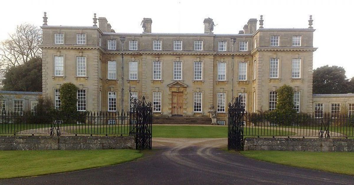
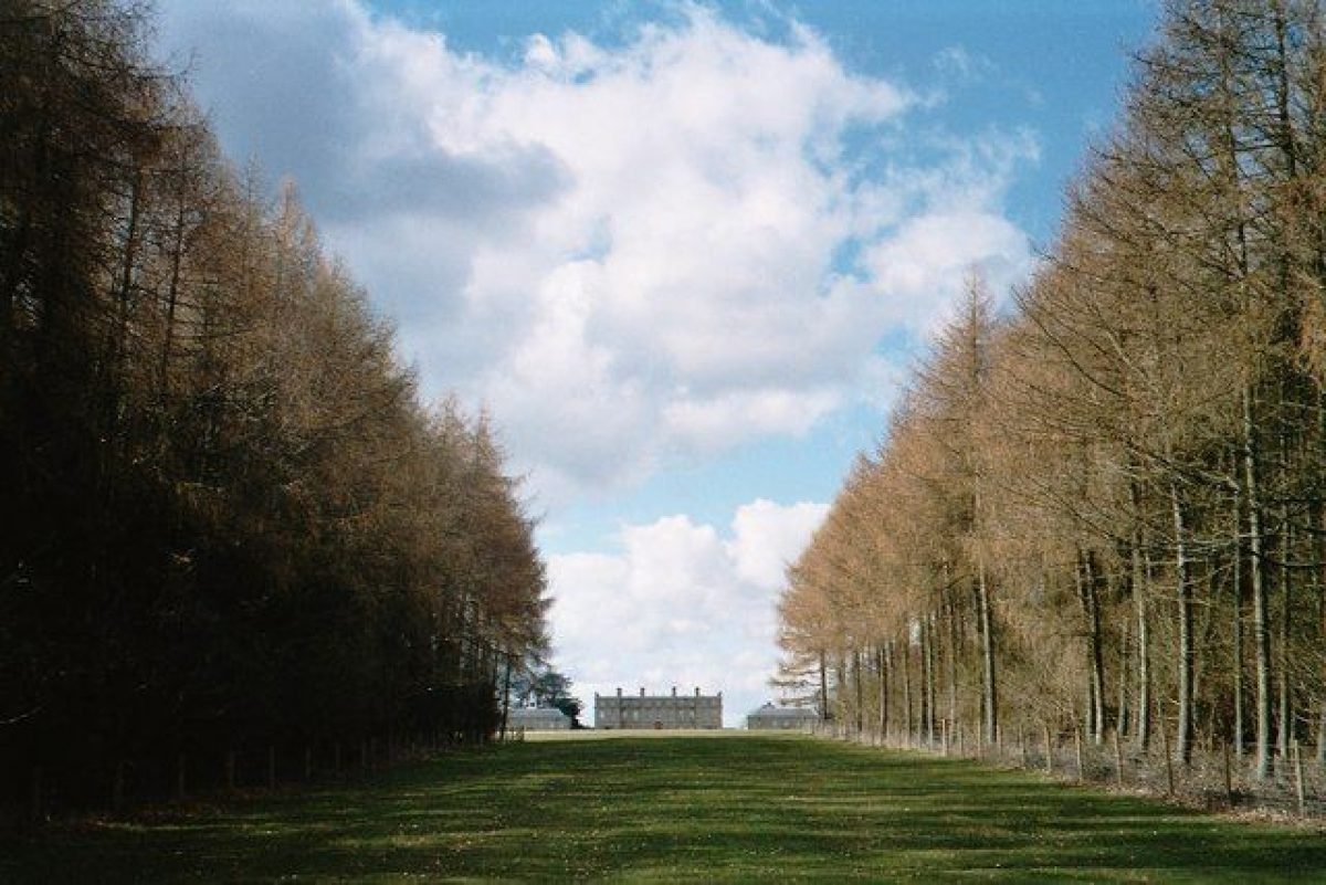
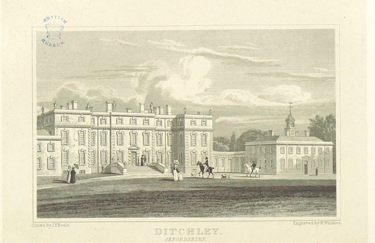
The main entrance to the park approaches off the A44 Oxford to Stratford road, along a lane which becomes the Kiddington Drive 1.2km north-east of the House. Flanked by a belt of woodland, through the south side of which runs part of Grim's Ditch, the drive continues, arriving at the eastern entrance to the park 700m from the House. The entrance, flanked by stone gate piers with large ball finials supporting wrought-iron gates (probably C18, listed grade II), is marked by the single-storey, stone Kiddington Lodge (early C19, listed grade II) standing on the north side. The drive continues west into the park, with views out to the north, arriving at the enclosed forecourt on the south-east front of the House. The forecourt, bounded largely by the main block of the House and its flanking pavilions, is defined to the south-east by a low stone wall, the central stretch of which is surmounted by a screen of wrought-iron railings flanking iron gate piers and gates (early/mid C19, listed grade II), with stone balustrading to either side. Within the forecourt the gravel turning circle, which encloses a panel of lawn, leads to a set of broad stone steps leading up to the main entrance. The steps are flanked by stone balustrades and piers supporting urns. South-east of the forecourt lies a broad, informal lawn, largely bounded by woodland, with a central ride cut through the south-east section, in line with the central front door and aligned on Blenheim Palace c 5km away on lower ground. A further ride, also aligned on the House, extends east, flanked by an avenue of trees. A third vista extends south, along the west drive, flanked by woodland, the three vistas together forming a patte d'oie. The west drive runs west beyond this, through the south park, leaving the park 600m south-west of the House and continuing through farmland to the Charlbury Lodges (early C19, listed grade II), a pair of two-storey, rendered brick houses with classical façades opposing each other across the drive.
A further drive extends north from the main drive, 50m east of the House, running through the park and pleasure grounds. This continues beyond the park as here registered into Dogkennel and Laurel Woods to Ellen's Lodge, a two-storey stone building standing 1.5km north-west of the House. The drive continues north, within a narrow belt of trees, through the hamlet of Fulwell, until it emerges c 3km north-east of the House onto the B4022 Charlbury to Enstone road. A spur off the north drive some 75m north-east of the House gives access to the Lions Court (probably Gibbs 1722, the whole listed grade II), a service court lying adjacent to the north-east front of the House. The entrance, flanked by stone piers surmounted by statues of lions set into a stone wall, gives onto a short, straight drive flanked by stone walls. Behind these lie two small, walled, rectangular kitchen gardens. The drive, aligned centrally on the north-east front, emerges into the gravelled main court, bounded to the north-west by a stone retaining wall against the great terrace, to the north-east by the kitchen garden walls and to the south-east by the east pavilion. Within the southern of the two walled gardens lies a central, circular stone pond.
PRINCIPAL BUILDING
Ditchley House (James Gibbs 1722, listed grade I) stands towards the centre of the park, at the south-east edge of the extensive pleasure grounds. The rectangular, stone, three-storey main block is set back from two two-storey flanking service pavilions to which it is connected by quadrant link corridors, the western of which contains a curved conservatory overlooking the formal garden. Ditchley is Gibbs's most important surviving country house, remaining one of the finest and most complete early Georgian houses of this type. The main block overlooks to the north-west, from its main garden front, a convex shoulder of land covered by part of the pleasure ground which runs down to the fishpond in the valley, and beyond this the former north park. Views extend north-west from the upper floor and the roof across the north park and surrounding woodland, particularly aligned along Shilcott and Heythrop Lights. The garden front is linked to the pleasure grounds by steps down from the central garden door onto a broad stone-flagged terrace, with further steps leading down to the adjacent great terrace (both terraces Jellicoe 1930s). The two-storey, stone, former stable block (early/mid C18, listed grade II), now a workshop and flat, stands 130m north of the House, adjacent to the north drive.
GARDENS AND PLEASURE GROUNDS
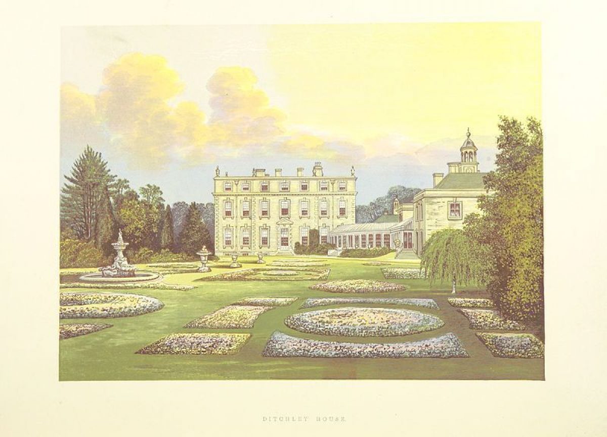
The formal Italian Garden (Jellicoe 1936) lies adjacent to the south-west front of the House, commissioned by Ronald and Nancy Tree to cover an area formerly laid to informal lawn with a central fountain and specimen trees which extended south from the main body of the pleasure grounds (OS 1881). Jellicoe produced an Italian-style sunk garden, as requested, entered from the south-west front down stone steps flanked by iron balustrading to a stone-flagged terrace, now flanked by box-hedged knots with small, central stone ponds, formerly laid out as small parterres (Garden Hist 1982). Stone steps from the terrace lead down to a rectangular lawn, encircled by a gravel path and flanked by raised stone-walled terraces on which stand pleached lime allées. The lawn was formerly planted as a parterre with formal arrangements of beds and topiary specimens (ibid). The allées lead down to intimate, yew-hedged, stone-paved enclosures flanking the semicircular former bathing pool lying 100m from the House, approached from the outer side by a flight of curved stone steps leading down to the water. Formerly the pool, when in use, was concealed from the House by 6m high jets of water forming a water curtain which ran along its straight edge. Ornamental lion's head fountains within plinths surmounted by urns formerly stood at the top of the steps, spouting into the pool (Spens 1994). A ha-ha beyond the pool allows uninterrupted views along the axis of the garden into the park beyond, along a broad avenue of trees planted in 1830, to the park boundary. Parallel to the south, separated from the main axis by a yew hedge, lies a smaller enclosed garden. A central lawn leads from the south-west front of the south pavilion to a raised, gravelled stone terrace backed by clipped yew hedges. Formerly the area covered by the lawn was laid out for Nancy Tree with a series of geometrical beds (Garden Hist 1982).
The great terrace lies parallel with, and to the north of the formal garden, separated by a clipped yew hedge and adjacent clipped beech hedge. The terrace extends north-east for c 300m, past the garden front of the House, to a point c 110m north of the House. Jellicoe was commissioned by the Trees to 'interpret but not copy the lines of the 1726 plan, providing these lines, in my judgement, were good' (Spens 1994), including rebuilding the massive terrace depicted (actually constructed in the C18 on the line of Grim's Ditch, to designs by Gibbs, although Jellicoe and the Trees thought that it had never been built). At the south end of this grass, earth-banked terrace stands the Little Temple (mid/late C18, listed grade II), moved by the Trees in 1935 from the north of the pleasure grounds. It is a rectangular stone summerhouse with a canted Venetian window in the rear wall overlooking the park and Grim's Ditch. Its main face overlooks the terrace to the north, standing at the top of a series of grass banks, the view enclosed and directed along the terrace by the beech hedge to the south and the pleasure ground cedar trees to the north. The terrace terminates at its north-east end in a steep drop overlooking the park to the east and countryside beyond. Steps down from here give access to the pleasure ground, close to a small, stone, classical octagonal building with a pyramidal roof, formerly a menagerie (c 1745, listed grade II), now set within a group of yew trees.
The c 32ha, informal, wooded pleasure ground are bounded by Grim's Ditch to the south and east and by a stone ha-ha to the north, with views over the park to the south and the former park to the north. The area contains several informal grass paths and is dominated by the central pond which runs through the valley bisecting the area from west to east. A large, open informal lawn, bounded on the west side by large specimen Lebanon cedars, runs north-west from the House down to the pond, connecting with the perimeter walk around it. At the east end an earth bank acts as a dam, standing above marshy lower ground to the east which may formerly have been a quarry, before a brief period as a pond which did not hold water properly (Garden Hist 1982). The path crosses the dam, continuing along the north side of the pond to the west end where the large Rotunda (Stiff Leadbetter c 1761, listed grade II*) stands overlooking the water, some 600m north-west of the House. The perimeter path continues south around the pond, across the west end, carried by an earth ramp above a grotto (c 1734, listed grade II) accessible only by water. A round-arched central opening leads into the grotto chamber with its watery floor, flanked by retaining walls in which two further openings lead to dry passages beneath the ramp. The path continues around the south side of the lake, below the site of two former icehouses (OS 1884). Traces of a C19 perimeter walk through the woodland remain, but this is largely overgrown.
Two main vistas extend from the garden front across the pleasure grounds. Heythrop Light cuts through the pleasure ground woodland into the north park, towards Laurel Wood on the skyline, aligned on Heythrop Park house c 6km distant. Temple Vista extends north-west to the Rotunda.
Following the landscaping of the estate in the mid C18, many American trees were planted in the pleasure grounds, possibly acquired from the American Lee family. Some 143 species of American trees have been recorded in the old quarry area below the lake (Jones, 1982). The pleasure grounds were laid out by J C Loudon c 1805(10 during his time at nearby Tew Lodge, as shown by a map (based on the OS 1st edition 25", 1881) annotated by one of the family (Oxfordshire RO). On this is printed 'Pleasure ground, taken out of the park by Chas Viscount Dillon and laid out by Loudon'. Loudon describes this himself in his In the Modern and Approaching Style of Rural Improvement (1807, 12).
PARK
The park lies south and east of the pleasure ground. It contains the largely level Little Park, lying south of Grim's Ditch and extending south to the Charlbury Drive, which contains an avenue of sycamores planted by Henrietta Viscountess Dillon in 1830. Beyond lies the Deer Park, extending north as far as Home Farm and the walled garden. The remains of several avenues exist, largely centred on the south-east front of the House, shown in detail on the OS 25" map published 1881. The avenues were connected c 300m from the House by the semicircular, beech Rainbow Avenue (felled 1959), which linked the southern double avenue along the Charlbury Drive close to the House with the eastern Kiddington Drive, continuing on to the north. These may be the remains of an early C18 formal scheme, contemporary with Gibbs' work. A dip in the ground 300-400m north-east of the House, close to the Kiddington Drive, indicates the possible site of the earlier house, aligned on the former Shampire's Light running through Ash Copse to the south-west of the park.
The former north park (not included within the registered area) now consists of a central core of arable fields enclosed by woodland. New Park (probably laid out in the mid/late C18 by the third Earl (Davies, 1797; Bryant, 1826)) lies at the western edge, formerly planted as parkland with many specimen trees (OS 1884) but now open arable land. Henry Flitcroft is said to have designed New Park Lodge in 1769 for the third Earl (Leslie 1987), but this has now (1998) gone. It was probably sited at the west corner of New Park, at the south end of Inott's Clump, at the west end of a former drive running from west to east across to the east corner of New Park (Davies, 1797; OS 1884, 1923). The north park is overlooked by the pleasure ground, and in views from the upper floors of the House acts as a backdrop, with the lights cut through the surrounding woodland.
KITCHEN GARDEN
The kitchen garden lies 400m north of the House, on a south-facing slope above Home Farm. The 1.5ha garden, the north half now disused and somewhat overgrown and the south half under pasture, is bounded to the north and east by stone walls, faced internally with brick, the south wall having been entirely removed. At the west end stands the Garden Cottage (early/mid C18, listed grade II), a stone, two-storey former bothy, with a large central alcove, plastered and colourwashed, facing east along the main axis of the garden. The cottage was formerly flanked by garden walls; part of that to the south is still extant. A drainage ditch extends east from the cottage; formerly stone lined and covered with stone flags, traces of the stonework are still visible. This terminates at the east wall, in line with an ornamental doorway giving access to the woodland beyond. A second enclosure, which lies adjacent to the north of the walled garden, is now planted with fruit trees.
West of the cottage lies a formal lawn enclosed by clipped yew hedges, with square, stone-lined pools, the lawn narrowing to the west and leading to a gate onto the drive from the House. This was possibly part of Jellicoe's maze 'which nobody except myself seems to have enjoyed' (Garden Hist 1982).
REFERENCES
Country Life, 75 (9 June 1934), pp 590-5; (16 June 1934), pp 622-8; 178 (24 October 1985), pp 1173-7
N Pevsner and J Sherwood, The Buildings of England: Oxfordshire (1974), pp 572-6
D Stroud, Capability Brown (1975), p 222
F Woodward, Oxfordshire Parks (1982), p 10
Garden History 10, no 1 (1982), pp 80-91
D Ottewill, Edwardian Gardens (1984), p 200
C Leslie, The Ditchley Gardens, (unpub ms 1987).
M Spens, The Complete Landscape Designs and Gardens of Geoffrey Jellicoe (1994), pp 48-51
Ditchley Park, guidebook, (1995)
Maps
Edward Grantham, Map of Ditchley, 1726 (Oxfordshire County Record Office; related maps at Bodleian Library)
A plan of the coach road through Lord Litchfield's field from Blenheim to Blandford Park, 1753 (Oxfordshire County Record Office)
Enclosure map, 1779 (Oxfordshire County Record Office)
R Davis, A New Map of the County of Oxford ..., 1797
A map of the roads as set out by the Commissioners of the Spelsbury Enclosure, 1803 (Oxfordshire County Record Office)
A Bryant, Map of the County of Oxford ..., surveyed 1823
A Jones (CPRE), Ditchley Park, 1982 (copy on EH file)
OS 6" to 1 mile:
1st edition published 1884
2nd edition published 1900
OS 25" to 1 mile: 1st edition published 1881
Description written: March 1998; Amended: March 1999; April 1999
Register Inspector: SR
Edited: January 2000
- Visitor Access, Directions & Contacts
Telephone
01608 677346Access contact details
Open to groups only, by arrangement only, Mon - Fri only. 01608 677346 http://www.ditchley.co.uk/hire-of-ditchley/tours
Directions
http://www.ditchley.co.uk/contact-us/how-to-find-us
- History
The following is from the Register of Parks and Gardens of Special Historic Interest. For the most up-to-date Register entry, please visit the The National Heritage List for England (NHLE):
www.historicengland.org.uk/listing/the-list
HISTORIC DEVELOPMENT
In 1583 Sir Henry Lee of Quarrendon, near Aylesbury, Ranger of Woodstock Park, bought a house and land at Ditchley. In 1603 he acquired a license to enclose a substantial deer park and in 1608 and 1610 James I hunted at Ditchley. In 1722 James Gibbs began a new house for Lee's descendant, the second Earl of Litchfield, probably siting it away from the old, timber-framed house (which may have stood 300-400m east of the new house). Gibbs also constructed a long terrace ranged against the garden (north) front of the House, with avenues radiating from the entrance front in goose-foot form. This terrace, which incorporates the Saxon earthwork Grim's Ditch, is shown in a plan of 1726 (Garden Hist 1982). It is said that on a clear day Blenheim Palace to the south and Heythrop to the north could be seen along the vast avenue vistas between these estates (Batey in Raphael et al 1982). In the mid 1740s the old fishpond was converted into an ornamental lake, perhaps with a Chinese bridge and grotto head. The terrace was probably removed during landscaping works of the 1760s when the landscape around the House was largely naturalised and Stiff Leadbetter designed the Rotunda temple. The pleasure grounds seems to have been enclosed c 1805(10 by the twelfth Viscount Dillon (d 1813), and laid out by John Claudius Loudon. The seventeenth Viscount died in 1932, and in 1933 Ronald and Nancy Tree bought the House and park, employing the young Geoffrey Jellicoe from 1933 to 1938 to design an Italianate formal garden and reinstate Gibbs' terrace. Sir Winston Churchill, a friend of the Trees, spent weekends at Ditchley during the early 1940s, when the moon was up and it was feared that he would not be safe at Chequers (qv). The Trees sold Ditchley in 1949; in 1953 it was bought by Sir David Wills, who gave the House, gardens and part of the park to the Ditchley Foundation, for use as a conference centre to promote Anglo-American relations, in which use it remains (1998).
- Associated People
- Features & Designations
Designations
The National Heritage List for England: Register of Parks and Gardens
- Reference: GD1432
- Grade: II*
Style
English Landscape Garden
Features
- Lake
- Pond
- Temple
- Summerhouse
- Fountain
- Description: Ornamental lion head fountains
- Lawn
- Specimen Tree
- Parterre
- Terrace
- Sculpture
- Herbaceous Border
- House (featured building)
- Now Conference Centre
- Earliest Date:
- Latest Date:
- Bathing pool
- Ditch
- Grotto
- Description: Grotto chamber with watery floor
- Key Information
Type
Park
Purpose
Ornamental
Principal Building
Domestic / Residential
Survival
Extant
Hectares
180
Open to the public
Yes
Civil Parish
Spelsbury
- References
References
- {English Heritage Register of Parks and Gardens of Special Historic Interest}, (Swindon: English Heritage, 2008) [on CD-ROM] Historic England Register of Parks and Gardens of Special Historic Interest
- Ottewill, D., {The Edwardian Garden} (New Haven; London: Yale University Press, 1989) The Edwardian Garden
- Stroud, D., {Capability Brown} (London: Faber, 1975), p. 222 Capability Brown
- Pevsner, N. and J. Sherwood, {The Buildings of England: Oxfordshire} (Harmondsworth: Penguin, 1974), pp. 572-6 The Buildings of England: Oxfordshire
- Askew Nelson {Ditchley Park Parkland Plan} (2014) Ditchley Park Parkland Plan
- Related Documents