Introduction
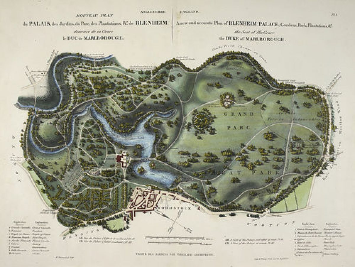
Laid out by Sir John Vanbrugh and Henry Wise in the 1720s for the Duke of Marlborough, Blenheim has formal gardens and pleasure grounds within a landscape park, the whole site covering 975 hectares.
Terrain
The park lies at the foot of the Cotswold dip slope, the Great Park in the north half being situated on a high plateau, dropping down to the undulating Lower Park to the south, with the flooded Glyme valley separating the two.The following is from the Register of Parks and Gardens of Special Historic Interest. For the most up-to-date Register entry, please visit The National Heritage List for England (NHLE):
A country mansion surrounded by an extensive and complex park and pleasure grounds, created from the medieval royal hunting park of Woodstock. Main phases early and mid C18 and early C20, with early C18 work by Henry Wise and John Vanbrugh, mid C18 work by Lancelot Brown and early C20 work by Achille Duchene.
NOTE This entry is a summary. Because of the complexity of this site, the standard Register entry format would convey neither an adequate description nor a satisfactory account of the development of the landscape. The user is advised to consult the references given below for more detailed accounts. Many Listed Buildings exist within the site, not all of which have been here referred to. Descriptions of these are to be found in the List of Buildings of Special Architectural or Historic Interest produced by the Department of Culture, Media and Sport.
SUMMARY DESCRIPTION
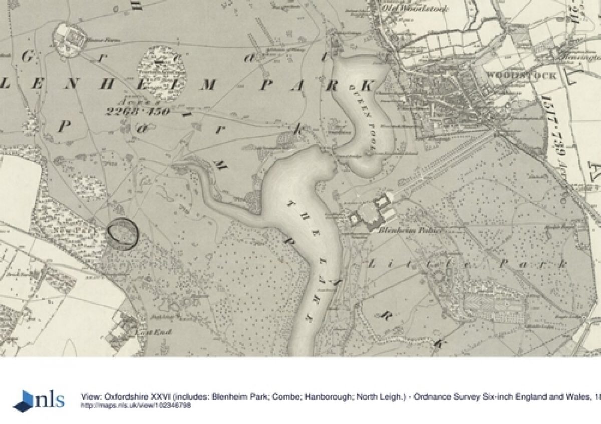
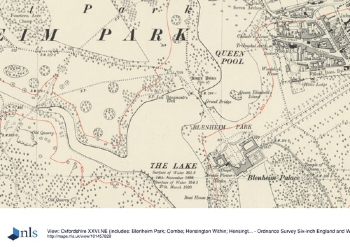
Blenheim lies c 12km north-west of Oxford, adjacent to the south-west side of the village of Woodstock, within the confines of the medieval Forest of Wychwood. The c 10 sq km site is bounded largely by a c 14km long stone park wall (masons William Townesend and Bartholemew Peisley Junior, c 1720s, listed grade II), apart from a stretch along the south boundary west of Bladon, with to the east the A44 Oxford to Stratford-upon-Avon road and to the south the A4095 road to Witney. The village of Bladon straddles the valley adjacent to the south boundary, the parish church tower being prominent in views from the south front of the house. The park lies at the foot of the Cotswold dip slope, the Great Park in the north half being situated on a high plateau, dropping down to the undulating Lower Park to the south, with the flooded Glyme valley separating the two. The setting is largely rural and agricultural, with the C18 town of Woodstock against the east park wall, its church tower prominent from various points in the park. Numerous other views extend beyond the park from within.
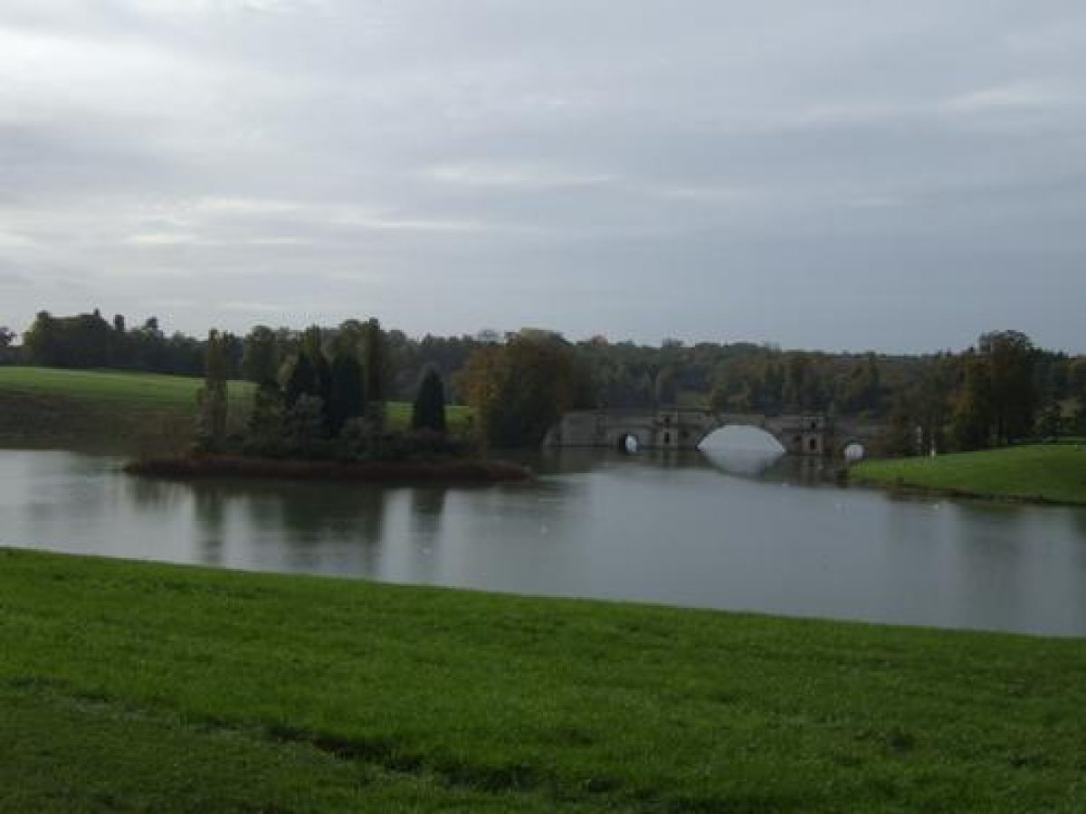
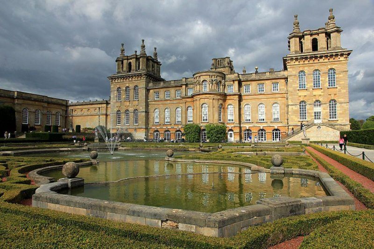
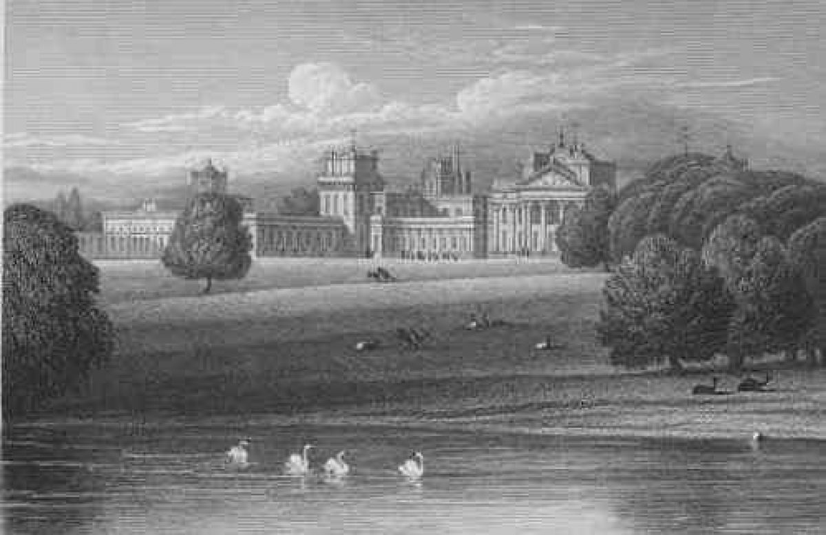
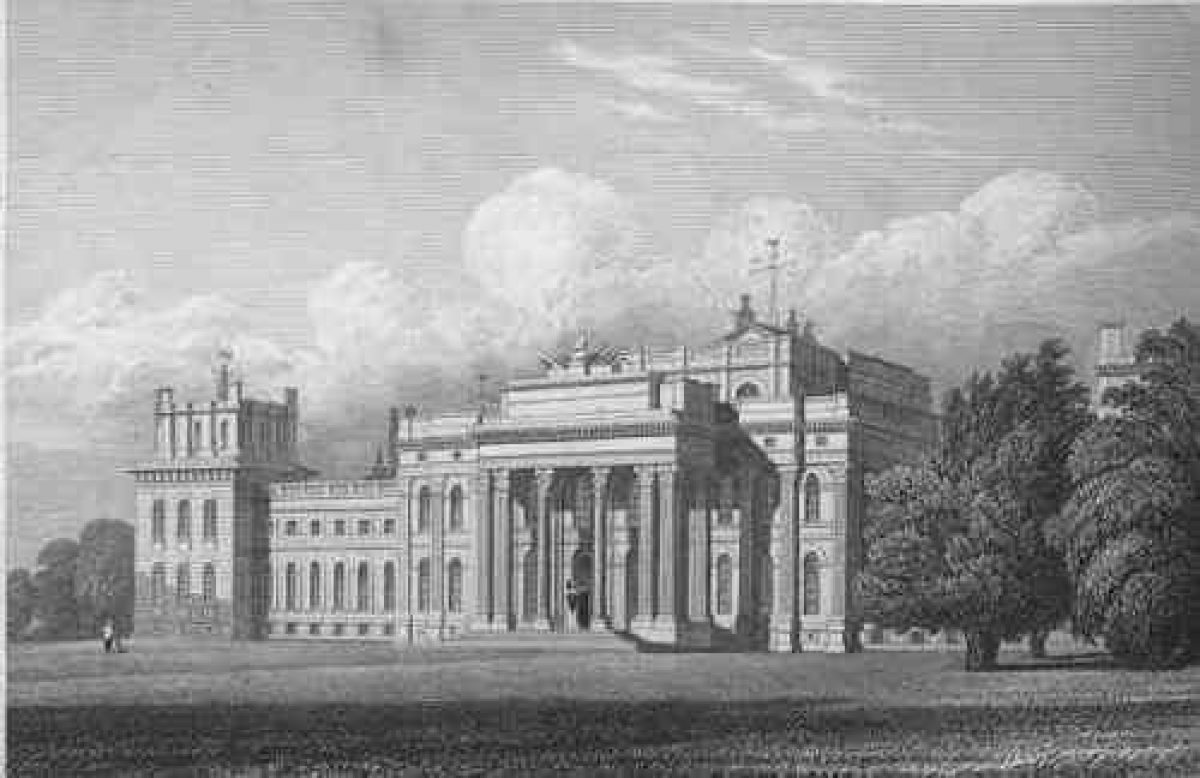
Blenheim Palace (Sir John Vanbrugh 1705-29, listed grade I) stands towards the centre of the park on a level plateau, approached via several drives and avenues. The main approach, directly from Woodstock via the Woodstock Gate, enters the park c 700m north of the Palace, passing through a square, stone-walled court, on the south side of which stands the Triumphal Arch (Nicholas Hawksmoor 1723, listed grade I). The drive emerges into the park, suddenly revealing Brown's lake divided by Vanbrugh's Grand Bridge (1706-12, listed grade I) standing in the valley below. To the north-west the Column of Victory (to a design by Lord Herbert, later ninth Earl of Pembroke, 1727-30, listed grade I) is prominent on high ground across Queen Pool and to the south the roofscape of the Palace is visible, the main facade partially hidden. The drive continues south, with panoramic views across the Glyme valley, joining, 300m north-east of the Palace, the straight drive from the monumental Hensington Gate (1706-10, moved to present position 1770s, listed grade I). This drive enters off Oxford Road 800m north-east of the Palace, being aligned on East Gateway arch at the east end of a series of axially arranged openings between the courtyards north of the Palace. The drive curves north and west from the East Gateway, overlooking the lake, Grand Bridge and Column of Victory beyond, to join the Ditchley Drive at the entrance to the Great Court.
The Ditchley Drive enters the park 3km north of the Palace, flanked by a stone gateway with wrought-iron gates (John Yenn 1781, listed grade II), and a single-storey lodge (c 1860, listed grade II). The drive, aligned on the Column of Victory, and 1km beyond this the north front of the Palace, runs straight across the Great Park plateau, flanked by a double avenue of limes (replanted late C20 on the site of Wise's early C18 avenue, said to have been originally laid out in the formation of the Battle of Blenheim), being diverted 1.5km from the Palace into the wooded Icehouse Valley to the east, to remerge on the axial line 0.5km from the house. The drive crosses the Grand Bridge, standing 400m from the Palace, with views east to the Triumphal Arch and the buildings of Woodstock beyond the park wall, continuing up the valley side, arriving at a bastion forming the north side of the Great Court (remodelled by Duchene, 1910, to an early C18 pattern). The drive continues through the central gateway flanked by iron gates, crossing the large, level, paved and gravelled forecourt to the steps up to the portico on the north front. Several lesser drives, their entrances marked by lodges, traverse the park.
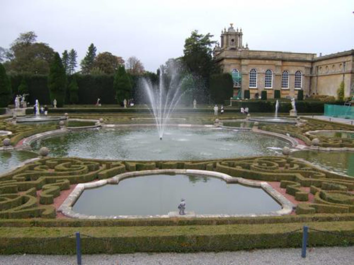
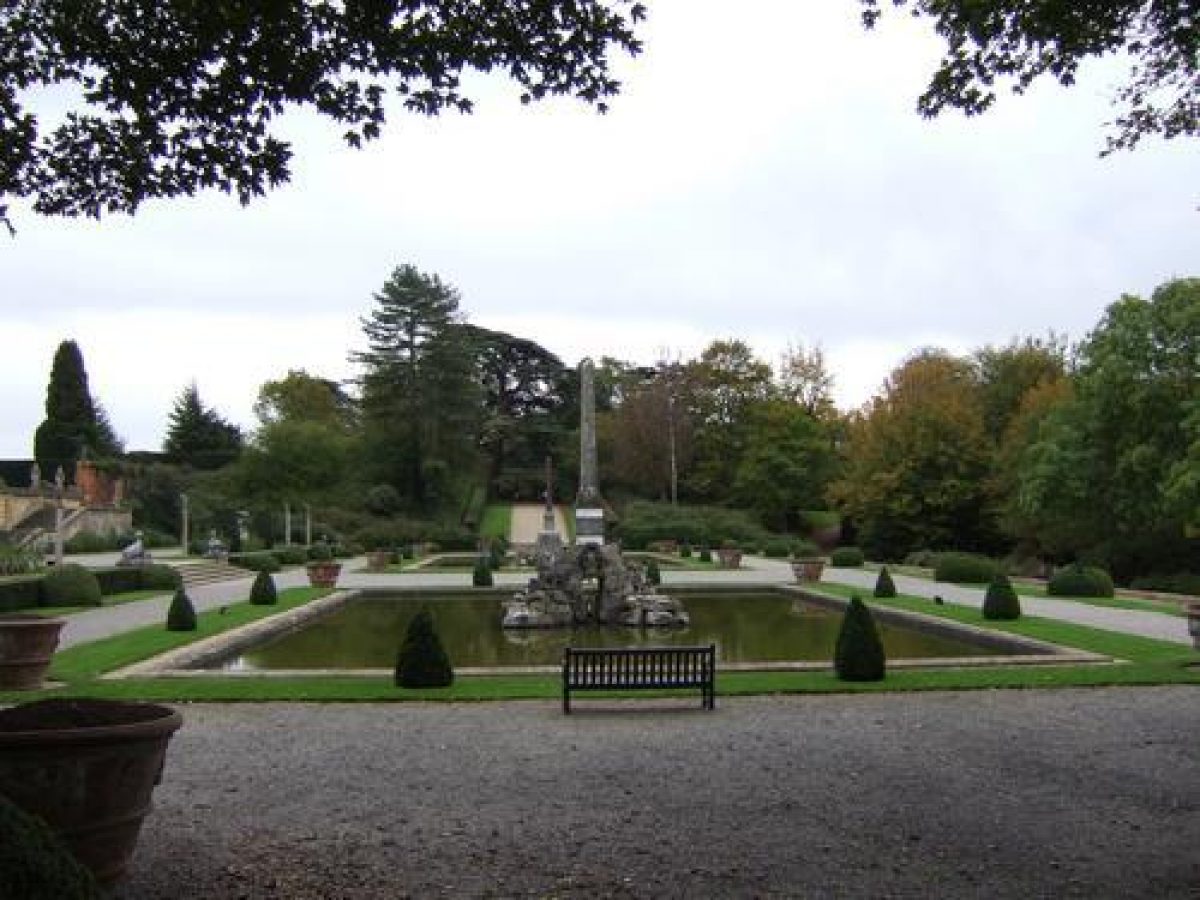
The Palace is flanked to the east by the Italian Garden (Duchene c 1910, steps listed grade II), containing box-hedged knots with Waldo Storey's central Mermaid Fountain (1900-10, listed grade II), and to the west by the Water Terraces (Duchene 1925-30, listed grade II), based on the Parterre d'Eau at Versailles. The upper terrace contains a series of linked pools within a framework of box hedging, whilst the lower terrace contains two rectangular ponds with central obelisks and fountains (the northern one called the Bernini Fountain, late C17, listed grade I) the whole overlooking the Lake, the hillside beyond, and, glimpsed at the top of the hillside, Brown's remodelled gothic High Park Lodge. South of the Palace, flanked by informal, wooded pleasure grounds containing three stone garden temples, lies an open, level lawn, formerly the site of Wise's Great Parterre (early C18), removed by Brown in the 1760s. Views extend south from the south front and lawn across the Glyme valley to Bladon and its church tower, with distant hills beyond. The east arm of the pleasure grounds leads to the kitchen garden. The west arm of the pleasure grounds leads south to Brown's Cascade, lying c 1km south of the Palace, at the south end of the earth dam retaining the Lake. The large, rocky Cascade, hidden from the main body of the Lake, conducts water back into the enlarged Glyme riverbed as it runs east, crossed by the three-arched New or Bladon Bridge (Sir William Chambers 1773, listed grade I), standing 850m south of the Palace, before curving south and west to leave the park west of Lince Bridge. Laurel Bank, south of the river, seems to contain the remains of pleasure grounds which may have been linked with the former rock and flower gardens lying closer to the south side of the Cascade.
The park is divided into several sections, mostly connected by Brown's Lake and the River Glyme to the south. The Great Park to the north is largely arable land with woodland clumps, bisected from north to south by the Ditchley Drive and from west to east by the Roman Akeman Street with the remains of Grim's Ditch in the north section, and dominated by the Column of Victory. A tablet marks the site of the former Woodstock Palace, lying c 500m north-west of the Palace on what is now the north bank of the Lake. West of this, 200m west of the Grand Bridge, lies Rosamund's Well, a spring and stone pool marking the site of the former bower created in the mid C12 by Henry II for his mistress, Rosamund de Clifford. By the C15 the site contained a suite of rooms and a cloister surrounding a paved courtyard, through which the spring waters were led through a flight of three pools (Bond and Tiller 1997). This was in ruins by the C16, the remains being sketched by John Aubrey in the C17. High Park, on the hillside west of the Lake, consists largely of ancient oak woodland in which, overlooking the Palace 1km to the north-east, stands High Park Lodge (Brown 1768, listed grade II*), remodelled in the Gothic style with a central three-storey tower and battlements, on the site of a medieval hunting lodge. The Lower Park and Bladon Park lie to the east and south of the pleasure grounds respectively, largely laid to pasture with many park trees.
The rectangular kitchen garden (masons Thomas Churchill and Richard Stacey, c 1710, listed grade II), covering 3ha, stands 600m south-east of the Palace, with four large, semicircular bastion walls projecting from the north and south walls, and two circular ponds.
REFERENCES
Note: There is a wealth of material about this site. The key references are cited below.
N Pevsner and J Sherwood, The Buildings of England: Oxfordshire (1974), pp 459-75
D Stroud, Capability Brown (1975), pp 111, 218; pls 27-30
Victoria History of the County of Oxfordshire 12, (1990), pp 430-70
Blenheim Palace, guidebook, (1996)
J Bond and K Tiller, Blenheim, Landscape for a Palace (rev edn 1997)
Maps
R Davis, A New Map of the County of Oxford ..., 1797
A Bryant, Map of the County of Oxford ..., surveyed 1823
OS 6" to 1 mile:
1st edition published 1878-80
2nd edition published 1900
OS 25" to 1 mile:
1st edition published 1876
Description written: March 1998
Amended: March 1999;April 1999
Register Inspector: SR
Edited: January 2000
- Visitor Access, Directions & Contacts
Telephone
01993 810530Website
https://www.blenheimpalace.com/Access contact details
The site is open daily except Christmas Day. Opening times for different parts of the site are variable. Please see: http://www.blenheimpalace.com/planyourvisit/opening-times-and-prices.html
Directions
Six miles north-west of Oxford on the A44 Evesham road. Train to Oxford, then No. 20 bus.
Owners
Duke of Marlborough
- History
The following is from the Register of Parks and Gardens of Special Historic Interest. For the most up-to-date Register entry, please visit the The National Heritage List for England (NHLE):
www.historicengland.org.uk/listing/the-list
HISTORIC DEVELOPMENT
Henry I (1100-35) appears to have first enclosed the park at Woodstock at the beginning of the C12, it subsequently becoming an important royal hunting park. The park was focused on Woodstock Palace, a medieval hunting lodge of C12 origin, occupied by many monarchs and their spouses, who developed the buildings and surrounding gardens.
John Churchill, first Duke of Marlborough, was rewarded by Queen Anne in 1705 for his services in defeating the French in Europe, by the grant of the Royal Manor of Woodstock, given with the understanding that she would build him, at her own expense, a house to be called Blenheim (named after the 1704 victory at the battle of Blindheim, close to the Danube). The former royal hunting park was probably then in poor condition, and the remains of Woodstock Palace were pulled down (despite a letter from Sir John Vanbrugh (1709) to the Duchess pleading for its retention, on grounds of historical association, as an eyecatcher) and its gardens removed.
The new palace, built 1705-22, was designed, together with the monumental Grand Bridge over the little River Glyme, by Sir John Vanbrugh (assisted by Nicholas Hawksmoor), and was set within a great formal garden designed by Henry Wise (1653-1738), Queen Anne's Royal Gardener. Following the Duke's death in 1722, a formal canal scheme designed by Colonel Armstrong, his chief engineer, was implemented by the Duchess along the course of the River Glyme. In 1764 Lancelot Brown (1716-83) was called in, producing a plan to landscape the central core of the park which included flooding the river valley to produce a large lake, and landscaping the surrounds, with new belt plantings around the park boundary. In the early C19 the fifth Duke created a substantial rock garden and series of flower gardens (mostly gone) south of Brown's lake. In the late C19/early C20 the ninth Duke carried out much restoration and replanting within the park, and created formal gardens to the west and east of the house, designed 1908-30 by Achille Duchene. Restoration of park planting has continued during the C20, and the estate remains (1998) in private ownership.
Period
18th Century (1701 to 1800)
- Associated People
- Features & Designations
Designations
The National Heritage List for England: Register of Parks and Gardens
- Reference: GD1402
- Grade: I
World Heritage Site
Features
- Ornamental Lake
- Ornamental Pond
- Description: Two rectangular ponds with fountains
- Ornamental Fountain
- Cascade
- Description: Browns Cascade - large and rocky
- Ornamental Bridge
- Lawn
- Parterre
- Palace (featured building)
- Earliest Date:
- Latest Date:
- Water Terrace
- Description: Flight of three pools
- Spring
- Description: Rosamund's well - spring & stone pool
- Pond
- Description: Two ponds in the kitchen garden
- Ditch
- Description: Grim's Ditch
- Key Information
Type
Park
Purpose
Ornamental
Principal Building
Domestic / Residential
Period
18th Century (1701 to 1800)
Survival
Extant
Hectares
975
Open to the public
Yes
Civil Parish
Blenheim
- References
References
- {English Heritage Register of Parks and Gardens of Special Historic Interest}, (Swindon: English Heritage, 2008) [on CD-ROM] Historic England Register of Parks and Gardens of Special Historic Interest
- Stroud, D., {Capability Brown} (London: Faber, 1975), pp. 111, 218, plates 27-30 Capability Brown
- Pevsner, N. and J. Sherwood, {The Buildings of England: Oxfordshire} (Harmondsworth: Penguin, 1974), pp. 459-75 The Buildings of England: Oxfordshire
- Historic Land Management {Blenheim Palace Condition Survey Other Buildings and Structures} (2005) Blenheim Palace Condition Survey Other Buildings and Structures
- Colvin and Moggridge {Blenheim Park Landscape restoration and management An Action Plan} (1996) Blenheim Park Landscape restoration and management An Action Plan
- Historic Land Management {Blenheim Palace World Heritage Site Management Plan} (2006) Blenheim Palace World Heritage Site Management Plan
- Historic Land Management {World Heritage Site Management Plan Parkland Plan Appendices} (2006) Blenheim Palace World Heritage Site Management Plan Parkland Plan Appendices
- Colvin and Moggridge {Blenheim Park Parts of a Landscape Restoration Plan} (1982) Blenheim Park Parts of a Landscape Restoration Plan
- Jeri Bapasola {The Finest View in England - The Landscape and Gardens at Blenheim Palace} (Blenheim Estate Office, 2010) The Finest View in England - The Landscape and Gardens at Blenheim Palace