Introduction
Pollok Park is an open space a few miles from the centre of Glasgow, housing two museums and providing a range of recreational facilities. The former parkland includes several golf courses, which retain parkland planting. The grounds comprise 18th-century woodland gardens extended in the 20th century, an 18th-century walled garden, and formal terraces with parterres dating from the late-19th century.
http://portal.historic-scotland.gov.uk/hes/web/f?p=PORTAL:DESIGNATIONS:0
Location and Setting
Pollok Park lies 4 miles (6.5km) to the south-west of Glasgow City Centre. It is bordered by busy main roads, the B768 to the north, the B769 to the east, and the B762 to the south. There is a proposal to put a new major road link to Ayr from the M8, 1 mile (1.5km) to the north, southwards through the west margin of the park. The Glasgow/Irvine railway line cuts through the east margin of the park. The underlying geology is Carboniferous with the Upper Limestone groups to the south of the park and the Limestone/coal group to the north and west. (There was a limestone quarry to the north of Pollokhead Wood in 1741 and coal mines on what is now Haggs Castle golf course.) Above these rocks are drift deposits of boulder clay on the hillslopes and marine alluvial deposits on the former raised beach. The landform is relatively low-lying; the park is bisected by the river White Cart Water and, to the west and north, the land rises gently reaching 51m at North Wood. The Shawlands Burn flows from the north-east of the park to enter White Cart Water at the sawmill east of Pollok House. Post-war high-rise flats dominate the skyline to the south and west but otherwise the park woodlands screen the surroundings and restrict the views to within the park. The woodlands are dominant in the scenery from the surrounding area to west and north while the parkland and Pollok House are visible from the B762 cutting through the south of the park. The railway line to the east of the park obscures the view from this side.
Pollok House is set above the north bank of the White Cart Water facing south across the parkland. The designed landscape is bordered by the B768 and Haggs Castle to the north, by the B769 and the railway line through Pollokshaws to the east, and by minor roads and housing along its western boundary. This area has remained similar in extent since the mansion house was built in c.1752, with gradual incursions along its boundaries, and with the gradual development of recreational and other uses within the designed landscape. There are several plans of the estate besides the OS maps: Blaue's map of the River Clyde in 1662, Robert Ogilvy's map of Pollok estate in 1741 and John Ainslie's map of Renfrewshire in 1796.
The mansion house is set to take advantage of the view of the parkland and Pollokhead Wood to the south. The designed landscape at Pollok extends to 1,186 acres (480ha). (Pollok estate covers 1016 acres (411ha): of which 258 acres (105ha) are in agriculture; 295 acres (119ha) are of woodland; 333 acres (135ha) are under golf courses; and 43 acres (17ha) are grassland).
Landscape Components
Architectural Features
Pollok House, a mid-Georgian mansion was designed for the 2nd Baronet in 1750 on a site to the west of the former castle and extended from 1890 by Rowand Anderson; it is listed A. The site of the former castle or motte lies to the east of the present house in the woodland garden. The Square or Old Stable Courtyard containing part of the wall of the laighe castle is listed A. The Bridge over the White Cart Water was built in 1757 and is listed A. The Garden Terraces and Pavilions were designed by Rowand Anderson around 1904 and are listed A. The lions and urns on the terrace are sculpted by Hew Lorimer and the gates at the North Lodge are known as the Lorimer Gates. The Doocot and lodges are listed B. There are also the remains of an Ice House to the south of the river. The Burrell Collection was designed by Gasson and others in 1972.
Parkland
The parkland now accommodates many different uses including three golf courses; grazing land for Glasgow District Council's herd of Highland Cattle; sports pitches to the north and west of the estate; allotments, croquet and bowling clubs; the Police Dog and Horse Training Unit in the south of the park; and The Burrell Collection and associated parking area to the north-east of the house. The park to the south of Pollok House, now in use as a golf course, has kept many of its fine parkland trees, including sycamore, oak, lime, horse chestnut and beech species and has retained an open parkland character with few of the more unsightly trappings of a golf course. The only area of main grassland which is unfenced and open to the public is the area near The Burrell Collection. The former south drive is no longer open as a driveway, being gated south of the river; its sweeping drive would, in the past, have provided a stunning approach to the house. The roads within the park are tarmaced and now carry a great deal of traffic at peak times; major improvements are soon to be made. The 1888 Lime Avenue is a dominant feature to the north of the house, while only traces of the former avenue in the south of the park up to Pollokhead Wood on Baggershill can still be discerned. The East Lime Avenue, east of the house, was originally planted between 1756-1796 and was divided when the railway was put in in 1845.
There is an ancient tumulus south of the river which is now enclosed in a group of trees, but no trace remains today of the former Pollok Town. There were some famous Wych elms on the banks of the river a little to the east of the mansion house which were noteworthy in 1822; two were blown down in 1894 and two were felled in 1905 when they were recorded as about 300 years old. The elms in the park are also dying.
Woodland
Two areas of woodland, North Wood and Pollokhead Wood, have existed for many years, at least since 1741, although they have been replanted since then. The largest area of old woodland is part of North Wood with oaks and beech of 200 years in age, with younger mixed species, and a yew and Rhododendron understorey. There are old trees of beech, sycamore and oak throughout the park, remnants of old field boundaries incorporated into later plantings. During the latter half of the 19th century much tree planting took place; this included the park roundels and the shelterbelts along the lower field boundaries. The 10th Baronet undertook both replanting and new planting programmes from the late 19th century onwards, particularly in the north of the park, where beech, sycamore and Corsican pine species were used. At Pollokhead Wood in the south, there are many old beech trees and a high proportion of pines. There is a variety of species here planted 40-60 years ago. A very comprehensive Woodland Management Plan has been prepared by Glasgow District Council.
Woodland Garden
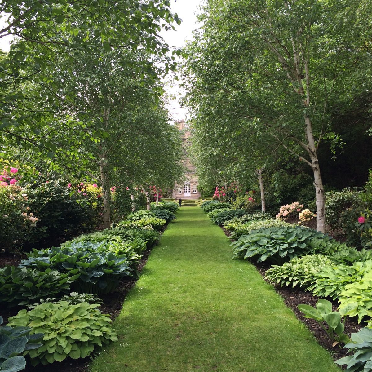
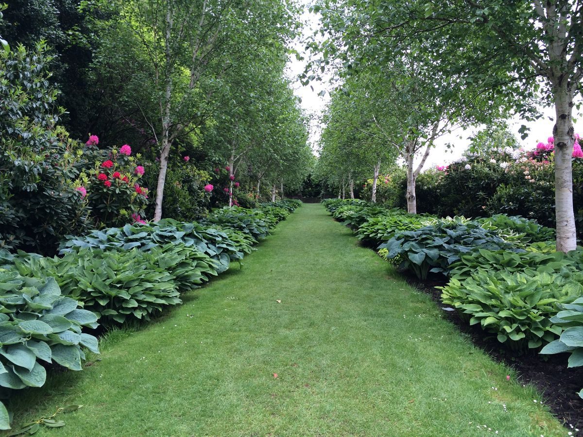
The woodland garden was first established during the time of the 7th Baronet, from the late 18th century onwards, and particularly by his wife Lady Hannah. Some of the older ornamental trees date from this period. The shrubbery was extended and improved by the 10th Baronet from 1910 onwards. It is surrounded by a 2m high hedge and contains ornamental trees such as Magnolias, maples, (Davidia involucrata), and also some of Sir John's collection of Rhododendrons. Paths of grass and gravel lead through the garden east from the house and down to the walled garden. Steps lead up to the main focal point of the garden, the site of the former motte castle now adorned by the massive spreading beech tree. Rhododendron planting was extended northwards from the woodland garden along the woodland drives and into North Wood. This area is overgrown but there is a clearance programme. There is an ancient fort in North Wood and also a pond, the origin of which is unknown but which is now used for nature study.
Water Features
The White Cart Water was canalised to the south of the house, probably by the 2nd Baronet who had the mansion house constructed. Records in 1782 by Semple refer to there being two cascades along this stretch of river, one on either side of the new bridge, put in by the 3rd Baronet in 1757.
The Gardens
The formal garden was designed by the 10th Baronet shortly after he came to Pollok and began improvements to the house. The garden pavilions were put in by Rowand Anderson at the same time as he carried out the additions to the house in the early 1900s. Sir John himself designed the parterres, both here and at his other house at Corrour, sketching designs of the many country house gardens he visited for the purpose. The parterres were originally formed with hedges infilled with gravel. The hedges to the east of the library remain but the gravel has been replaced with soil. The Alpine Wall was put in to the east of this parterre and is currently being replanted. The south parterres have now gone and are replaced by lawns, but the terrace walls, clipped hedges and decorative iron work remain. Two lions sculpted by Hew Lorimer now guard the upper terrace steps and there are several urns along the terrace.
Walled Garden
The walled garden is shown to the north of the laighe castle on the 1741 map; these two acres are recorded as being laid out 250 years ago as a kitchen garden and orchard with flowers and vegetables. Around 1900 there were many glasshouses, a hot wall and melon pits. Since 1975 the garden has been laid out as a Demonstration Garden, with display beds aimed at the amateur gardener with areas of scented plants, vegetables, fruit, shrubs etc. There is also a rose garden, (this has been closed due to the collapse of the retaining wall, its future is being reconsidered), and a garden for the disabled.
- Visitor Access, Directions & Contacts
Telephone
0131 668 8600Access contact details
Pollok Country Park is open daily throughout the year. The house is open daily from 10-5 except during the Christmas break.
Directions
Pollok House can be reached by courtesy bus from the Park entrance. For details see: http://www.nts.org.uk/Property/Pollok-House/Getting-there/
Owners
The National Trust for Scotland
Glasgow City Council
- History
The following is from the Historic Environment Scotland Gardens and Designed Landscapes Inventory. For the most up-to-date Inventory entry, please visit the Historic Environment Scotland website:
http://portal.historic-scotland.gov.uk/hes/web/f?p=PORTAL:DESIGNATIONS:0
Reason for Inclusion
The beautiful gardens, parkland, woodland and architectural features of Pollok Park make an enormous impact on the otherwise urban surrounding scenery. The park also has a long association with the Maxwell family and hosts and important Rhododendron collection.
Site History
The earliest known owner of Pollok was Roland de Mearns whose heiress, Mary, married Sir Aymer Maxwell of Caerlaverock. In 1270 Sir Aymer granted part of his estates, 'Nether Pollok', to his third son, Sir John Maxwell, 1st Knight of Pollok. The tower house or castle at this time was sited on the bank of the White Cart Water; this was replaced by the late 14th century by a new castle on higher ground to the north of the river, and a laighe, or low castle, was built on the site of the original keep as a second or dower house. In 1585 Haggs Castle was constructed to the north-east of the park and this became the Dower House; the laighe castle now forms part of the Old Stable Courtyard.
By 1710, Crawford referred to 'the curious orchard and gardens with large parks and meadows, excellently well planted, with a great deal of regular and beautiful plantings'. In 1737 the 2nd Baronet, Sir John, commissioned plans for a modern mansion house, which was built in 1750-52. The architect is not definitely known, although it is recorded that Sir John consulted William Adam. The new neo-classical house was sited on higher ground above the river and to the west of the previous two castles. Sir John died before it was finally completed and it was left to his son, also Sir John, to finish the work. The 1741 estate map shows a cherry orchard to the west of the laighe castle and a walled garden to its north. North Wood and Pollokhead Wood are marked on this plan, as also is Pollok Town, later moved completely out of the policies to Bogles Bridge so that it did not spoil the view from the new Pollok House.
The 3rd Baronet was responsible in 1757-8 for the building of a fine new stone bridge over the White Cart Water. It was gated for his own use and balustered. Semple recorded in 1782 that the 'River Cart played over two pleasant cascades, one on the east, one on the west of the Bridge'. He also mentioned 'a wooden bridge giving access to the gardens or pleasure ground which lies to the east side of the mansion house called the Green Bridge'. After a rapid succession of lairds, the 7th Baronet, Sir John Maxwell, inherited in 1785. Sir John and his wife Lady Hannah were known as improvers, Sir John concentrating on agricultural and silvicultural improvements, while Lady Hannah improved the gardens; she also painted the house and its setting in a series of watercolours around 1820. Sir John imported plant material from many countries, planted up the park, and added to the existing woodlands, particularly the 'rond-point' on the brow of the hill at Pollokhead Wood and the avenue leading up to it from the south of the house. Semple recorded in 1782 that the gardens included two wilderness areas, grottos, terrace walks, a bowling-green and a hot house and melonry.
The 1796 Ainslie map shows this mix of formal and informal styles, together with a main east entrance drive and avenue. Sir John died in 1844 and the estate was inherited by his son John, the 8th Baronet. Some improvements were made at Pollok during his time, including the building of a summerhouse in 1850 from the hollow remains of an old oak tree. In 1854, Hugh MacDonald in his 'Rambles around Glasgow' refers to Pollok where the 'gardens and pleasure grounds are of a princely scale of magnificence'. A porte-cochere was added to the house in c.1860 (and later removed by Rowand Anderson).
The 8th Baronet was succeeded in 1865 by his nephew William Stirling of Keir, who then took the name Stirling-Maxwell. He spent most of time at Keir where he developed the magnificent gardens there. The revised 1st edition OS map was issued in 1868 and shows no remaining trace of Pollok Town. Many individual trees are shown in the parkland and an avenue extended then to the west of the house. Entrance drives approach from the South Lodge across the White Cart Water and from the east, although the former main east entrance has been crossed by the Caledonian Railway and diverted to the south. The south avenue extends up to Pollokhead Wood but the rond-point of radiating avenues had disappeared by that date. The 9th Baronet died in 1878 but Pollok House was destined to remain empty over the next ten years until Sir John, the 10th Baronet, came of age in 1888 when he was given the choice of the two estates, Pollok and Keir, and chose Pollok. A lime avenue to the north of the house was planted as a gift for his coming of age and remains a splendid feature today.
Sir John commissioned Rowand Anderson the architect to carry out improvements to the house and lodges between 1890-1908 and he was also asked to design the garden pavilions and terraces in 1907. Sir John had meantime visited many country houses sketching designs for formal gardens and he designed the parterres put in to the south and east of the house at this time. In 1901 he married the daughter of Sir Herbert Maxwell, the well-known horticulturist and writer. Sir John collected horticultural books and carried out ornamental plantings in the grounds, at the same time treating the woodlands as a commercial asset and updating the sawmill. He developed a keen interest in rhododendrons and bred seven recognised hybrids at Pollok; he was a great friend of F.R. Balfour of Dawyck and Stewart of Shambellie. He subscribed to the 1925 Forrest expedition and to later plant collecting visits to the Himalayas, and developed rhododendron collections both at Pollok and at Corrour. In 1911 part of Pollok estate, the area of 121 acres (48ha) known as The Hill, was opened to the public. Sir John later became Chairman of the Forestry Commission and a founder member of the National Trust for Scotland. In 1939 Sir John made the first Conservation Agreement with the NTS, covering part of the parkland. Sir John died in 1956 and was succeeded by his daughter Mrs Anne Maxwell MacDonald who, in 1967, gifted Pollok House and 361 acres to the City of Glasgow making, as part of the gift, provision for the siting of The Burrell Collection which had been presented to the City of Glasgow by William Burrell in 1946. In 1980 this area was designated as a Country Park, and The Burrell Collection was opened to the public in October 1983. Pollok House is also open to the public as a museum.
- Associated People
- Features & Designations
Designations
Historic Environment Scotland An Inventory of Gardens and Designed Landscapes in Scotland
Features
- Icehouse
- Avenue
- Description: A lime avenue
- Earliest Date:
- Latest Date:
- Building
- Description: The Burrell, a purpose-built museum housing the Burrell Collection.
- Earliest Date:
- Latest Date:
- House (featured building)
- Description: Pollok House, a mid-Georgian mansion was designed for the 2nd Baronet in 1750 on a site to the west of the former castle and extended from 1890 by Rowand Anderson.
- Earliest Date:
- Latest Date:
- Parterre
- Earliest Date:
- Latest Date:
- Key Information
Type
Estate
Purpose
Recreational/sport
Principal Building
Parks, Gardens And Urban Spaces
Survival
Extant
Hectares
480
Open to the public
Yes
- References
References
-
Historic Scotland, 'Pollok Park (Nether Pollok)', {Gardens and Designed Landscapes},
Contributors
Historic Scotland
-
Historic Scotland, 'Pollok Park (Nether Pollok)', {Gardens and Designed Landscapes},