Introduction
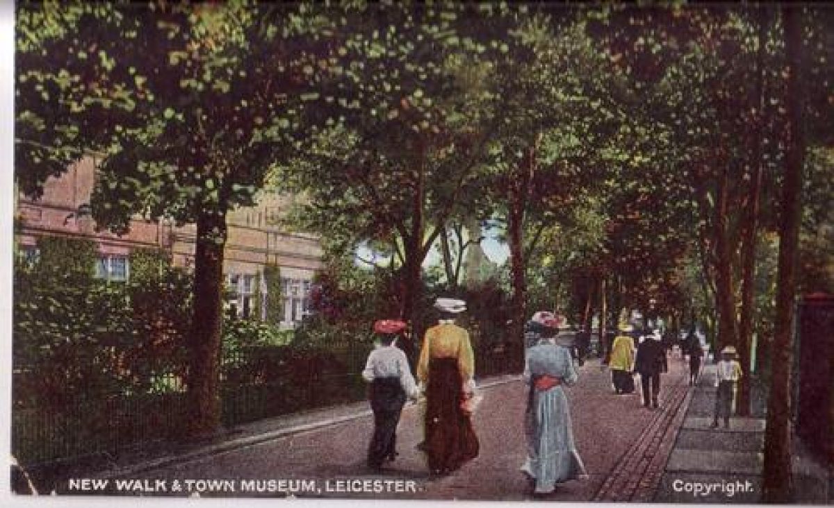
New Walk is a late-18th-century urban public walk, extending for 1100 metres, developed in the 19th century with residences and some public buildings.
Terrain
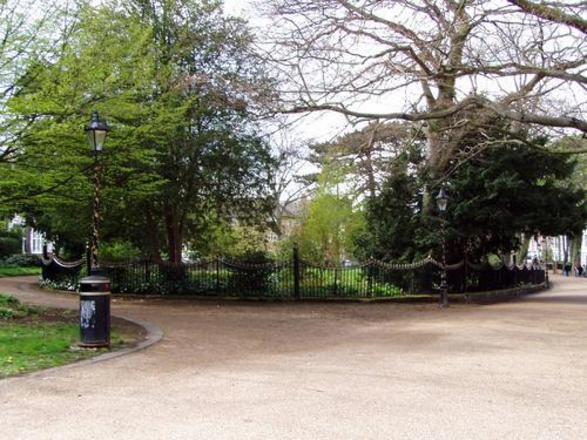
New Walk runs gently uphill from King Street to the northern tip of Victoria Park.www.historicengland.org.uk/listing/the-list
A public walk established in 1785, extending for 1.1 kilometres from the 18th-century fashionable quarter of Leicester to the town's racecourse, now Victoria Park.
DESCRIPTION
LOCATION, AREA, BOUNDARIES, LANDFORM, SETTING
New Walk runs gently uphill from King Street to the northern tip of Victoria Park. Other than the three open spaces on its southern side, it is lined predominantly with houses, many of which are now in commercial use. Public buildings along the Walk include two churches.
ENTRANCES AND APPROACHES
There are no gates or other formal entrances to the Walk.
OTHER LAND
The New Walk remains a traffic-free public walk. It is c 10m wide and tree lined, while the private houses and other buildings which line it are set back, according to the Corporation ordinances of 1824, by at least 9m and have no vehicular access off it. Many, particularly north-west of De Montford Square, are listed. Along the south side of New Walk are three open spaces: Museum Square, which contains the Museum (listed grade II), a large neo-classical building with pedimented portico, opened in 1849 in what had been built in 1836 to a design by J A Hansom as a Nonconformist Proprietary School; the much larger De Montfort Square, grassed, and with a statue (listed grade II) of 1870 of Robert Hall (d 1831), Baptist preacher, advocate of press freedom and supporter of Joseph Priestly, by J Birnie Philip; and the railed Oval, grass with some specimen trees. Public buildings along the Walk include the Roman Catholic Chapel (Joseph Ireland 1817-19) and St Stephen?s church (A R G Fenning 1893). There is much cast-iron street furniture along the New Walk, notably lamp standards and arches supporting a central light. It is of a pattern seen in Paris in 1895 by Alderman Faire. Whether any of the original ironwork remains is unknown; lights of the same pattern were installed in the 1960s, and the whole of the south side of the Walk was lit with columns of the same pattern imported from France in the 1990s.
REFERENCES
S Watts, A Walk Through Leicester (1804)
The Victoria History of the County of Leicestershire 4, (1958), pp 194-5, 373-4
Transactions of the Leicestershire Archaeological Society 44, (1968-9), pp 72-87
A E Brown, The Growth of Leicester (1970), pp 55-61
J Simmons, Leicester Past & Present (1974), pp 101-3
Trans Leicestershire Archaeol Soc 52, (1976-7), pp 62-8
M Taylor and G Wilson, The Quality of Leicester (2nd edition 1997), pp 62-70
Maps
OS 6" to 1 mile: Leicestershire sheet 31 SE, 1931 edition
Description written: April 1998
Amended: May 1999
Edited: July 1999
- Visitor Access, Directions & Contacts
Owners
Leicester City Council
New Walk Centre, Welford Place, LE1 6ZG
- History
The following is from the Register of Parks and Gardens of Special Historic Interest. For the most up-to-date Register entry, please visit the The National Heritage List for England (NHLE):
www.historicengland.org.uk/listing/the-list
HISTORIC DEVELOPMENT
In 1785 the Corporation proposed to establish a public walk, to be called Queen's Walk, extending from the fashionable Pocklington's Walk area to the racecourse. The New Walk, as it in fact came to be known, began at the junction of a newly built street with the Welford turnpike, which had been created about twenty years earlier. It was laid out just within the South Fields of St Margaret's parish, close to the boundary hedge which separated the open field land from the enclosed land beyond. The Corporation paid for the labour involved in its construction and supplied the gravel, while a public subscription of £250 paid for the trees and shrubs planted along it. Wide and pleasing views were enjoyed from almost everywhere along its length, across the unenclosed South Fields. Although in due course fashionable development spread along its length, until 1812 its character was entirely rural. The start of building was facilitated by the enclosure of the South Fields by Act of 1804 and Award of 1811, with part of the expenses thereof being defrayed by the sale of small lots along the line of the Walk. In fact, until 1824 there was very little building, and the Corporation restricted development to the north side of the Walk and entirely prohibited it on the south, which was reserved for gardens. In 1824 the Corporation gave permission for residential development of a type which would preserve the pedestrian character of the Walk, with covenants which stated that buildings had to be set back ten yards from it, and their gardens fronted with iron palisading. Gas lighting was installed in 1832, perhaps a recognition of the Walk's increasingly residential character. Even so the take up of plots was slow - only sixty had been built on by 1847 - and it was not until the 1860s that larger-scale development began. It was only in the late 19th century that development reached Victoria Park (see description of this site elsewhere in the Register), created at the end of the Walk by the Corporation in 1883 on the site of the racecourse. In 1969 the Walk was designated as a Conservation Area; since then many properties along its length have been renovated and there has been some renewal of trees and street furniture.
In 1840 a tunnel for the south-bound railway was cut through underneath the centre of the New Walk, and in the early 1970s Waterloo Way, a new road, was cut beneath the Walk on the west side of the railway.
Period
- 18th Century (1701 to 1800)
- Late 18th Century (1767 to 1800)
- Associated People
- Features & Designations
Designations
Conservation Area
- Reference: New Walk Conservation Area
The National Heritage List for England: Register of Parks and Gardens
- Reference: GD1961
- Grade: II
Features
- Designed Route
- Public And Residential Buildings
- Walk
- Key Information
Type
Designed Urban Space
Purpose
Recreational/sport
Principal Building
Parks, Gardens And Urban Spaces
Period
18th Century (1701 to 1800)
Survival
Extant
Open to the public
Yes
- References
References
- McKinley, R. A. {Victoria County History: Leicester, Volume 4} ([n.p.]: [n.pub.], 1958), pp. 194-5, 373-4 Victoria County History: Leicester, Volume 4
- {New Walk, Leicester, Restoration Plan} (1996) New Walk, Leicester, Restoration Plan