Introduction
Abbey Park is a late-19th century public park, formed from water meadows. The site was extended in 1925 by the addition of the adjacent Abbey Grounds.
Terrain
Abbey Park and Abbey Grounds lie on the north side of the city centre, to either side of the River Soar.www.historicengland.org.uk/listing/the-list/
A later 19th-century public park with axial design by William Barron.
Details
LOCATION, AREA, BOUNDARIES, LANDFORM, SETTING
Abbey Park and Abbey Grounds lie on the north side of the city centre, to either side of the River Soar. Abbey Park is bounded to the north-east by Abbey Park Road, to the south-east by the Grand Union Canal and to the north-west by the River Soar. A footbridge leads across the river to the Abbey Grounds which form the western part of the park and registered area. To the west the Abbey Grounds are bounded by St Margaret's Way, along which runs Abbot Penny's Wall (c 1500; listed Grade I), and Abbey Lane (the A6 to Loughborough) which delimit the abbey's precinct. The wall also runs along Abbey Park Road (off which St Margaret's Way leads), the northern boundary of the site, before turning south at the north-east corner of the Abbey Grounds along the bank of the River Soar. While most of Abbot Penny's Wall is of stone, and along Abbey Park Road up to 6m tall, the southern part of the length along St Margaret's Way contains a section which is of brick. The area here registered is c 40ha.
ENTRANCES AND APPROACHES
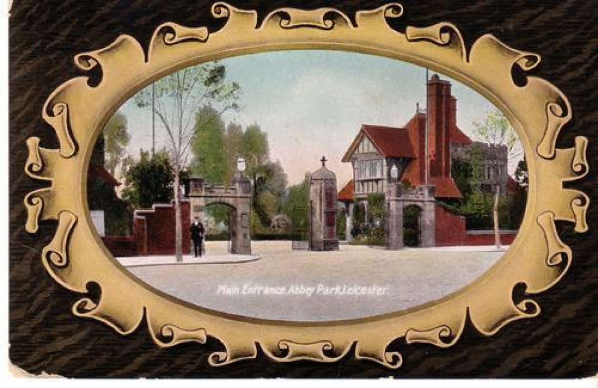
The main entrance gates to Abbey Park, which hang on squat brick and stone piers, open off Abbey Park Road. To either side are two-storey lodges (listed Grade II) of c 1880, similar but not identical, of brick with stone and timber-framed detailing. The architect was James Tait. Another entrance adjoins a single lodge (listed Grade II), also by Tait, at the south-east corner of the Park. There is an entrance to Abbey Grounds off Abbey Park Road, with a stone arch with flanking walls and low turrets of 1931.
PARK
The park is triangular, and c 800m in diameter. It is bisected by the River Soar, the two halves being connected by a footbridge. Its south-eastern part comprises the Abbey Park opened in 1882, while north-west of the river is Abbey Grounds, containing the Oval Sports Ground and the ruins of Leicester's Augustinian abbey (scheduled monument and listed Grade I).
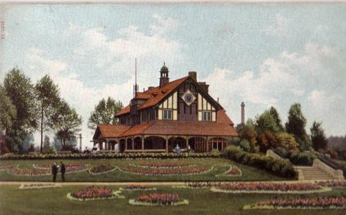
Extending south-west from the main entrance to Abbey Park, although screened from the gates by a shrubbery behind (south-west of) a small lawn with formal flower beds, is a roughly oval carriage drive, compressed to the centre to give a dumb-bell shape. An irregularly shaped lake with islands lies within the central area defined by the paths, with a much smaller lake to its north outside the circuit path which crosses the connecting channel via a Pulhamite bridge. On the north-east side of the main lake is a mound, laid out as a rockery with mature specimen trees. The mound was originally surmounted with an artificial ruin, while in 1891 the base of the mound was laid out in an educational manner with a model of Charnwood Forest employing geological and botanical specimens. North-east of the mound is an area of open grass with a bandstand of c 1882 at its centre. On the north-east side of the same area is a brick shelter of c 1931. At the south-west end of the lake is a Japanese Garden of c 1900 with railed paths, pergola, bridges and a small pavilion. To the south-west of the Japanese Garden, on a low mound, is an Education Centre of c 1960 which replaced an original Refreshment Pavilion designed by James Tait. The Education Centre is a single-storey building with a dramatic copper-sheathed roof. South-west of this structure a complex pattern of looping and radiating paths runs across and between the shaved lawns and formal beds which occupy the open semicircular area extending up to the main circuit path, around the edge of which is a shrubbery belt with mature specimen trees.
Paths lead from the main circuit path to that around the park perimeter, and to shelters and lavatories. North-west of the West Lodge at the main gate are late C19 brick service buildings and offices. North-west of these is a bowling green with mid C20 brick pavilion. North-west of that, adjoining the river in the northernmost section of the park, is a Garden of the Senses, opened in 1995 on the site of allotment gardens. In 1890 this area was a botanical garden where a number of young men received botanical instruction. At the other end of the park, beyond the south-west end of the circuit path, are tennis courts and a miniature model railway line installed in 1949 by the Leicester Society of Model Engineers for model railway enthusiasts. South-west of those is the St Margaret's Pasture Recreation Ground. This was bisected c 1960 by St Margaret's Way; that part beyond the new road is not included within the registered area.
The footbridge across the Soar, connecting Abbey Park and Abbey Grounds, is a low, five-arched stone structure of c 1931. It leads to the forecourt (with C20 statue of Cardinal Thomas Wolsey, who died at Leicester in 1530 and which stood originally on a factory of the Wolsey knitwear company) of a large, two-storeyed, brick Refreshment Rooms and sports pavilion of c 1931, around which there are formal beds and yew-hedged gardens which contain a lavender maze and ornamental vegetable garden. Steps and a balcony on the west side of the Refreshment Rooms look out across the Oval, a 300m long, grass sports ground around which runs a tree-lined circuit path. On the west side of the Oval, opposite the Refreshment Rooms, is a long, low, brick shelter of 1930. At the southern tip of the sports ground is a children's playground and a (now unused, 2013) paddling pool. North of the Oval, in the northern part of Abbey Grounds, are two separate sets of ruins. The main group (listed Grade I; scheduled monument) are the ground-level walls of St Mary's Abbey, founded in 1143 for Augustinian Canons, and one of the order's largest houses in England. North-west of those are the remains of Cavendish House (listed Grade I; scheduled monument), built c 1600 and burnt down in 1645. Built on to the north side of Cavendish House is a C19 residence which at present (2013) is an independent school (under lease). A tree-lined walk along the western riverbank, between it and the precinct wall, was established c 1880, and was commended as a promenade in 1890.
Selected Sources
Book Reference - Author: Chandler, J - Title: John Leland's Itinerary Travels in Tudor England - Date: 1993 - Type: DESC TEXT - Description: pp. 76-79
Book Reference - Author: Simmons, J - Title: Leicester past and present. Vol. 2 - Date: 1974
Book Reference - Author: H Conway - Title: People's Parks. The Design and Development of Victorian Parks in Britain - Date: 1991 - Page References: pp 26, 45, 71-2, 80
Book Reference - Author: Chadwick, G F - Title: The Park and the Town - Date: 1966
Book Reference - Title: Victoria County History: Leicestershire IV - Date: 1958 - Page References: p 294
Book Reference - Author: J Storey - Title: Historical Sketch of Borough of Leicester - Date: 1895
Book Reference - Title: J Horticulture and Cottage Gardener - Date: 31 July 1890 - Page References: pp 94-6
Article Reference - Date: 12 September 1885 - Journal Title: The Gardening World - Page References: p 24
Article Reference - Date: 24 October 1891 - Journal Title: The Gardening World - Page References: pp 118-19
Book Reference - Author: M Elliott - Title: Victorian Leicester - Date: 1979 - Page References: pp 155-6
Book Reference - Author: E J Emery - Title: The History of the Abbey Park, Leicester - Date: 1982
Other Reference - Description: DNB Missing Persons (1993), [Barron, Wm]
Book Reference - Author: M Taylor and G Wilson - Title: The Quality of Leicester - Date: 2nd edn 1997 - Page References: pp 102-5
Reasons for Designation
Abbey Park, Leicester, opened in 1882, is designated at Grade II* for the following principal reasons:
* Date: the park is a good example of a later Victorian municipal park;
* Design: the park's original design is little altered;
* Designer: the park was designed by the leading designer William Barron;
* Historic interest: the park includes Abbey Grounds, with the scheduled ruins of St Mary's Abbey and of Cavendish House;
* Structures and planting: the park retains various C19 and C20 structures including listed lodges and many mature trees, including a tree-lined riverside walk.
Date first registered: 05-Mar-1986
Date of most recent amendment: 20-Aug-2013
- Visitor Access, Directions & Contacts
Telephone
44 116 454 1003Website
https://www.leicester.gov.uk/your-council-services/lc/parks-green-spaces/main-parks/abbeyparkmain/Access contact details
Open Daily.
Directions
One mile north of the City Centre.
Owners
Leicester City Council
New Walk Centre, Welford Place, LE1 6ZG
- History
The following is from the Register of Parks and Gardens of Special Historic Interest. For the most up-to-date Register entry, please visit the The National Heritage List for England (NHLE):
www.historicengland.org.uk/listing/the-list/
History
Abbey Park was opened in 1882 in St Margaret's parish, very near to the most crowded district in the town. It was Leicester's second public park, Victoria Park (qv) having opened about two years previously. Abbey Grounds, which forms the western part of the modern park, opened in 1931 having been donated to the Corporation in 1925.
The area occupied by Abbey Park was formerly the Abbey Meadows, which were acquired by Leicester Corporation in 1876. The idea of a public park in this area had previously been canvassed in the local press, and an opportunity to act upon the suggestion came out of flood works proposed under the Leicester Improvement Act of 1876. A competition to design Abbey Park was won in 1879 by William Barron (d 1891), nurseryman and garden designer of Borrowash (Derbyshire), who had previously been Head Gardener at Elvaston Castle (Derbyshire) (qv). His plan has a sophisticated axial design, although this is difficult to discern on the ground. Although the plan did not indicate where specific activities were to be enjoyed, it was his intention that different areas demarcated by paths and shrubberies be given over to sports provisions including an archery ground, lawn tennis courts, a cricket ground and bowling green. The park was formally opened in May 1882, ground works having gone on alongside flood works. The cost of the park and associated improvements (not including flood works) was high at c £50,000, about twice the Corporation's annual income from rates, and was 'bitterly criticised and contested' (Simmons 1974, 38).
In 1931 the park was extended after the gift to the corporation in 1925 of the ruins of St Mary's Abbey, where Cardinal Wolsey died in 1530, together with ground (the Oval) to its south.
- Associated People
- Features & Designations
Designations
The National Heritage List for England: Register of Parks and Gardens
- Reference: GD1954
- Grade: II*
Features
- Boating Lake
- River
- Description: The site is bounded to the north-west by the River Soar.
- Canal
- Description: The site is bounded to the south-east by the Grand Union Canal.
- Ornamental Bridge
- Description: A footbridge leads across the river to the Abbey Grounds which form the western part of the park and registered area.
- Wall
- Description: The site is contained within Abbot Penny's Wall, which dates from around 1500. This is mostly built of stone, but the southern part has a brick section.
- Earliest Date:
- Latest Date:
- Parkland
- Water meadows
- wa
- Key Information
Type
Park
Purpose
Recreational/sport
Principal Building
Parks, Gardens And Urban Spaces
Survival
Extant
Hectares
23
Open to the public
Yes
- References
References
- {English Heritage Register of Parks and Gardens of Special Historic Interest}, (Swindon: English Heritage, 2008) [on CD-ROM] Historic England Register of Parks and Gardens of Special Historic Interest
- McKinley, R. A. {Victoria County History: Leicester, Volume 4} (London: [n.pub.], 1958), p. 294 Victoria County History: Leicester, Volume 4
- Historic Land Management {Abbey Park Landscape Management Plan} (1996) Abbey Park Landscape Management Plan