Introduction
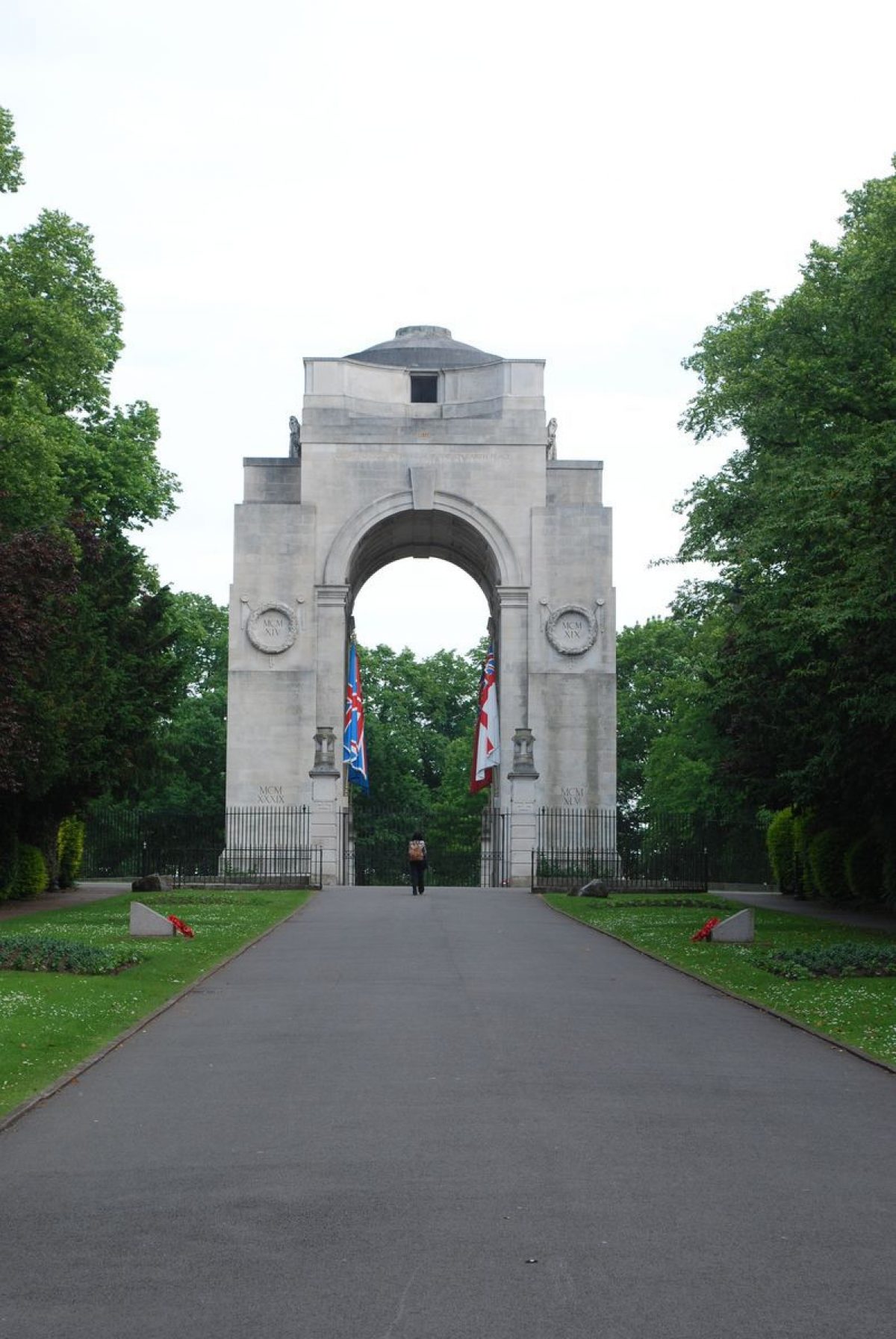
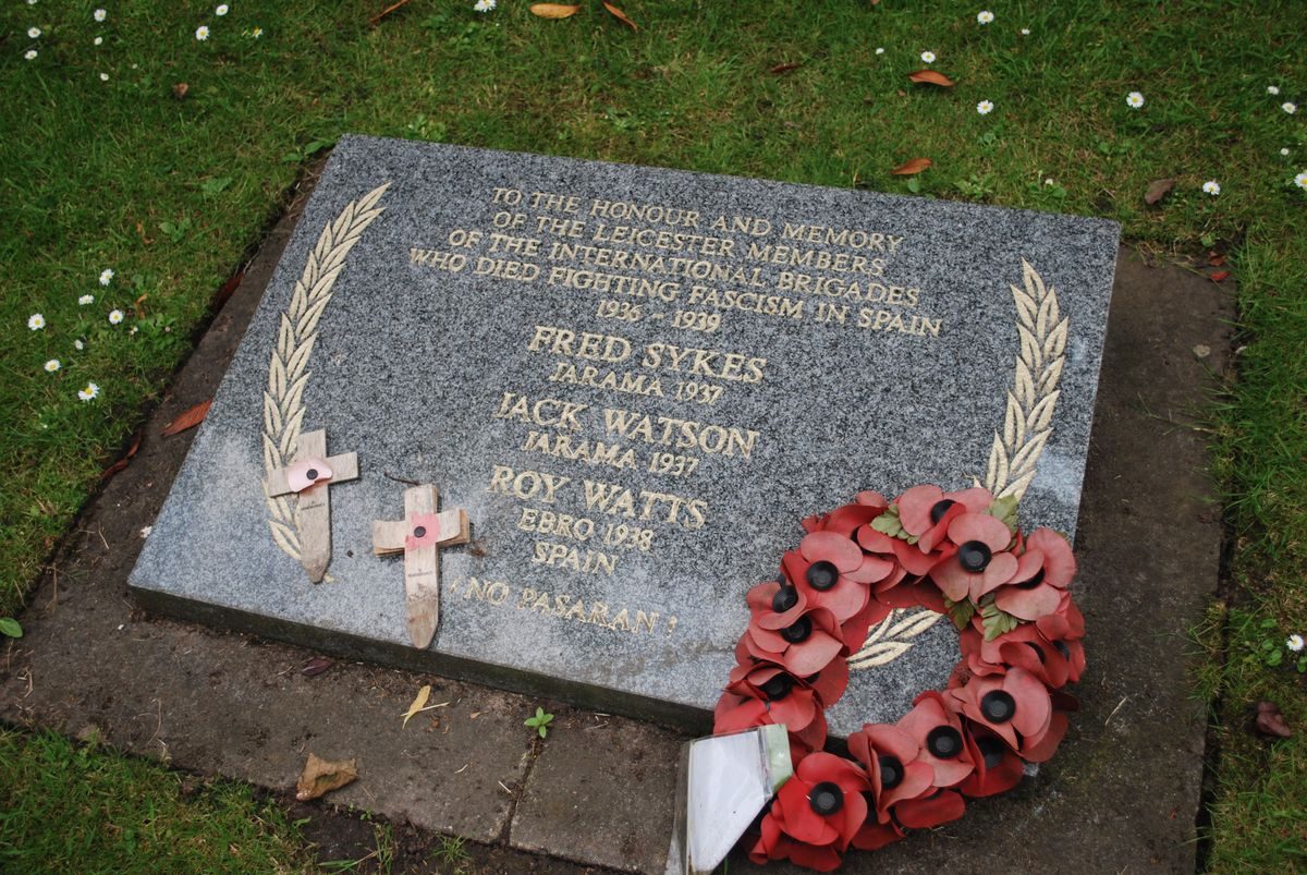
Victoria Park dates from the late-19th century. The park contains two war memorials, one designed by Edwin Lutyens. There is also a bowling green and various sports pitches.
www.historicengland.org.uk/listing/the-list
Details
Late C19 public park, considerably developed C20, c.35ha. From late C18 and most of C19, the site of Victoria Park was a racecourse, and New Walk (q.v.) was laid out in 1785 partly to provide access to the racecourse from the town. Victoria Park laid out 1883, extending south and south-west from London Road. Park sited on level ground, with wide expanses of grass, crossed by mainly straight paths lined with trees. Trees along outer boundaries. Small play areas and ornamental shrubbery. Principal monument the War Memorial, 1923, by Lutyens, mid-way down the south-west boundary, with formal avenue - War Memorial Approach - and regular planting of massed bedding, shrubs and trees for 150m north-west to gates and gate piers, by Lutyens 1923, onto University Road. Related lodges and gates 1930 by Lutyens, 320m to north-north-east of War Memorial, at northern extremity of Victoria Park. Park now bounded to south-west by Leicester University, whose science buildings, erected since 1957, directly south of War Memorial Approach, replace 5ha of sports facilities (playing fields, tennis courts, bowling greens). Subsequent creation of bowling green with restaurant and sports pavilion in northern area of park, to south-east of entrance lodges, other sports facilities in southern area of park. Tennis courts to north-west, between War Memorial and entrance lodges, and opposite the adjacent gardens of the De Montfort Hall (1913), which is situated outside Victoria Park, and north of War Memorial Approach, surrounded by formal floral bedding and shrub borders.. Pevsner N, Williamson E, Brandwood G K, Leicestershire and Rutland, 1984, 261. A municipal park of 1883 with, to one side, a monumental War Memorial and ceremonial approach by Sir Edwin Lutyens.
DESCRIPTION LOCATION, AREA, BOUNDARIES, LANDFORM, SETTING
The park lies south-east of the city centre. To the north-east the park is bounded by London Road, the A6 to Market Harborough, and to the south-east by Victoria Park Road, the B6416, which leads off it. To the west the park abuts Granville Road and the campus of Leicester University, and the registered area extends west to include the grounds of De Montfort Hall. The area here registered is c 35ha.
ENTRANCES AND APPROACHES
The main gates are at the park's northern tip, at the end of New Walk (qv) which leads from the town centre. Single-storey stuccoed lodges to either side (listed with gates grade II*) are of 1931 or 1933, and were designed by Sir Edwin Lutyens (1866-1944). The drive which passes through them, used for car parking, is aligned on the War Memorial. Lodges, gates and the ceremonial approach to the War Memorial were the gift of Sir Jonathan North.
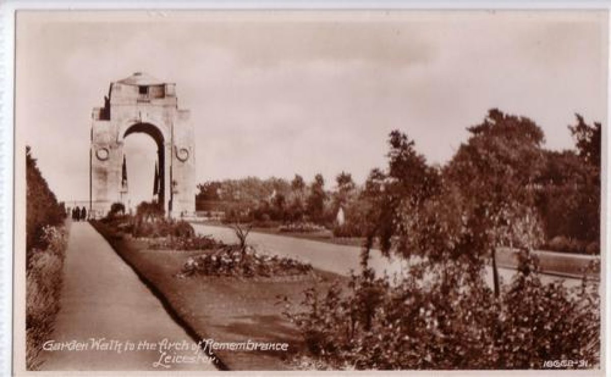
A second formal entry to the park is via the 150m long War Memorial Approach (renamed Peace Walk in the early 1980s), a tree-lined processional approach with massed bedding and shrubs, linking University Road with the War Memorial, which stands at its south-east end. On University Road are gates and screen (listed grade II*) of 1923 by Sir Edwin Lutyens, incorporating six Portland stone piers topped with urns and with an ornate overthrow incorporating Leicester's coat of arms.
PARK
The park is roughly rectangular, and the main park (excluding the 200m square grounds of De Montfort Hall) extends c 750m from north to south and is c 400m wide. Apart from the mature trees (most planted 1888 x 1904; many elms lost to disease in 1970s) which run around the edge of the park and line the paths across it, it is largely featureless open grassland, some of which is used for sports pitches. South and south-east of the northern entrance is a two-storey refreshment building and various sports facilities, constructed in the 1960s to replace facilities lost when the University campus expanded onto playing fields south of the War Memorial Approach.
The park is dominated by Leicester's main War Memorial (listed grade I), of 1923 and by Sir Edwin Lutyens. This stands on the western edge of the park, at its junction with the grounds of De Montfort Hall. Of Portland stone, it comprises a square monumental arch, stepped at the top and crowned with a shallow dome. Around it is a circle of rusticated piers with vases which carry iron railings.
De Montfort Hall (listed grade II) is of 1913. Its forecourt is taken up with a turning circle with formal flower beds, while to its south-west are situated greenhouses in a grassy area with specimen trees.
In the later C18 the site of the park became Leicester's racecourse. The races were moved to a new course near Oadby in 1880 and the land, long owned by the Corporation, was laid out as Victoria Park. It opened in 1883. There were moves early in its history to enhance it with shrubberies and a botanical gardens, but nothing came of these.
REFERENCES
The Victoria History of the County of Leicestershire 4, (1958), p 294
M Elliott, Victorian Leicester (1979), pp 155-6
M Taylor and G Wilson, The Quality of Leicester (2nd edn 1997), pp 142-7
Maps
OS 25" to 1 mile: Leicestershire sheet 31.15, 1st edition published 1888
Leicestershire sheet 31.15, 2nd edition published 1904
Description written: April 1998
Amended: May 1999
Register Inspector: PAS
Edited: July 1999
- Visitor Access, Directions & Contacts
Access contact details
This is a municipal site, open daily for general public use.
Owners
Leicester City Council
New Walk Centre, Welford Place, LE1 6ZG
- History
The following is from the Register of Parks and Gardens of Special Historic Interest. For the most up-to-date Register entry, please visit the The National Heritage List for England (NHLE):
www.historicengland.org.uk/listing/the-list
HISTORIC DEVELOPMENT
The park opened in 1883 on land used from the later C18 until 1880 as the town's racecourse. The War Memorial was constructed in 1923. The De Montfort Hall, which it adjoins, opened in 1913.
- Associated People
- Features & Designations
Designations
The National Heritage List for England: Register of Parks and Gardens
- Reference: GD1965
- Grade: II
Features
- Bowling Green
- War Memorial
- Description: A Memorial Arch designed by Sir Edwin Lutyens, commemorating the First World War.
- Earliest Date:
- Latest Date:
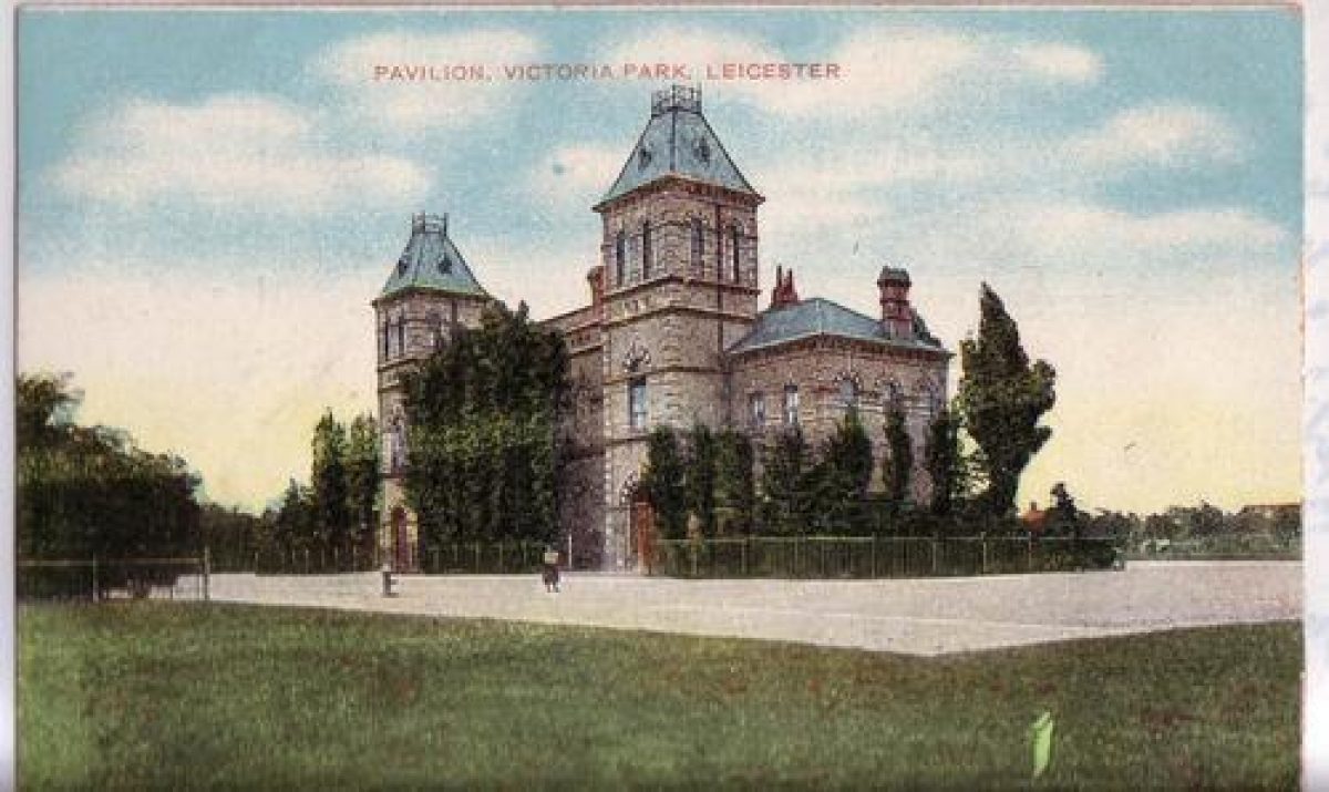
- Pavilion
- Description: The pavilion replaced one which was damaged in the war.
- Earliest Date:
- Latest Date:
- Walk
- Description: Peace Walk leads to the war memorial.
- Leisure and sport facilities
- Key Information
Type
Park
Purpose
Recreational/sport
Principal Building
Parks, Gardens And Urban Spaces
Survival
Extant
Hectares
35
Open to the public
Yes
- References
References
- {English Heritage Register of Parks and Gardens of Special Historic Interest}, (Swindon: English Heritage, 2008) [on CD-ROM] Historic England Register of Parks and Gardens of Special Historic Interest
- Pevsner, N., {The Buildings of England: Leicestershire and Rutland} (Harmondsworth; Penguin, 1984). p. 261 The Buildings of England: Leicestershire and Rutland
- McKinley, R. A. {Victoria County History: Leicester, Volume 4} ([n.p.]: [n.pub.], 1958), p. 294 Victoria County History: Leicester, Volume 4
- Parks and Green Spaces Services {Management Plan Victoria Park 2012-17} (2011) Management Plan Victoria Park 2012-17