Introduction
Lydiard Park is a mid-18th century landscape park, with woodland and farmland. Much of the estate is currently undergoing restoration, due to be complete in 2009.
The following is from the Register of Parks and Gardens of Special Historic Interest. For the most up-to-date Register entry, please visit the The National Heritage List for England (NHLE):
www.historicengland.org.uk/lis...
Mid-18th-century park and garden laid out by the second Viscount St John, incorporating features and archaeological remains of a late 17th-century formal park and garden. Details
Location, Area, Boundaries, Landform and Setting
Lydiard Park, a level site of c 149ha situated in the parish of Lydiard Tregoze, lies immediately west of Swindon, between the M4 to the south and the village of Lydiard Millicent to the north. The north-east part of the site is bounded by a small stream with late-C20 housing further beyond. To the north-west the site is enclosed by farmland belonging to Parkside Farm which abuts the northern boundary.
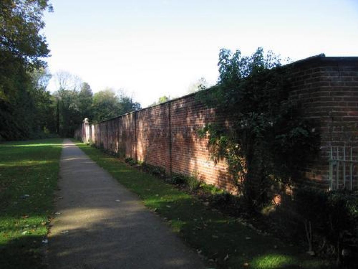
The southern boundary is formed by Hook Street (formerly called Park Lane), with Lydiard Residential Park (excluded from the area registered here) covering part of Park Copse. To the south is farmland belonging to Lower Hook Farm, situated to the south-west, and Park Farm which abuts the far south-east corner of the site. The south-east boundary is formed by a ditch and stone wall, which are possibly medieval in origin (English Heritage 2000). The wall is lined to its east by a public footpath (outside the area here registered), and beyond it a school and its grounds (late C20).
From various points within the park there are extensive views of the surrounding land that once formed part of the Lydiard Estate, including one in a southerly direction towards the site of a former C18 folly (not included in the land registered here). As marked on the OS map of 1828, this stood on a ridge in fields south of the lakes at Lydiard.
Entrances and Approaches
The main approach lies to the south, formed by a tree-lined drive which enters off Hook Street c 570m south-west of the House and runs in a north-easterly direction to the north-west side of the House. This drive, replanted in the late C20 in a modified form, originates from c.1700 (Map of Lydiard Park). The drive to the church was created c.1812. A further approach enters 400m east of the House, where a lime avenue leads off Hay Lane in a westerly direction to a small car park to the north-west of the House and the church of St Mary. This avenue, laid out in 1911, was formerly planted with elm trees, which were replaced by lime trees in 1980. The site can also be entered by various public footpaths which cross the north-east part of the park (OS 1886).
Principal Building
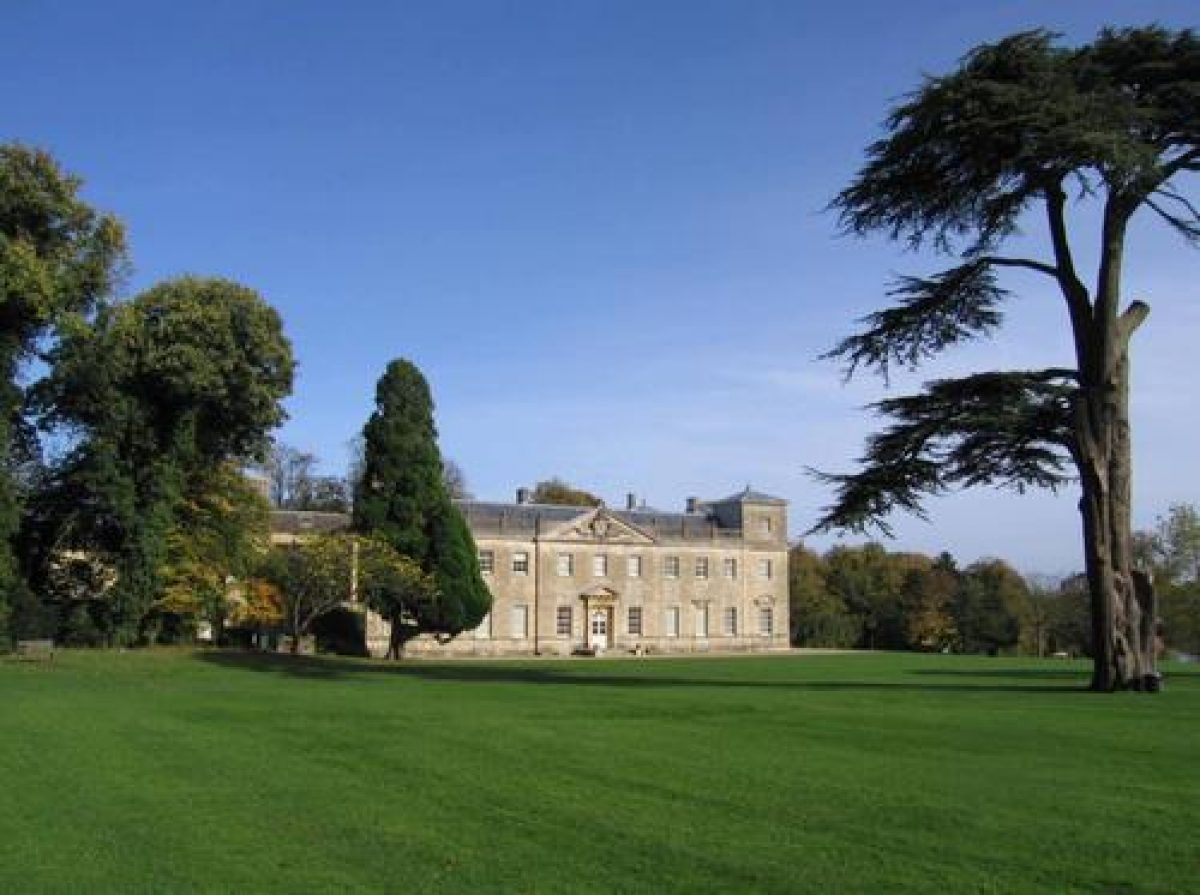
Lydiard House (listed at Grade I) is situated in the eastern half of the site. Together with the Church of St Mary (listed at Grade I; and several Grade II listed tombstones in churchyard) which is situated immediately to its north, it forms an important group of buildings dating back to the medieval period. The fabric of the House dates mainly from the C17, but the south-west and south-east fronts are in the Palladian style, following their remodelling of 1742-3 by the second Viscount St John. This remodelling has been attributed to the architect Roger Morris (CL 1948). Attached to the rear north-west end of the house is a late-C20 conference wing. The former L-shaped stable block, now converted to a cafe, offices and education centre, stands circa 30m to the north-west of the house.
Gardens and Pleasure Grounds
The pleasure grounds consist of a small woodland to the south-west of the House, since the late C19 called The Avenue, separated from the park by an C18 ha-ha built of brick (restored late C20), and a terrace and lawn to the south front of the House.
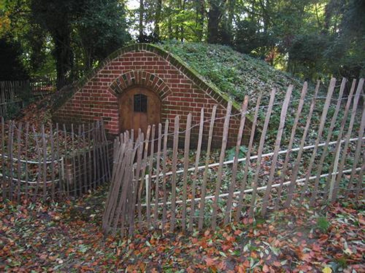
The woodland, which contains a network of paths and some mature trees, is crossed by the south drive and west avenue (see below). In the woodland, c 140m south-west of the House, stands an C18 icehouse (listed at Grade II, and recently restored) with, approximately 60m further to its south-west, a visitor centre introduced in the 1980s. Attached to the woodland to the south-east lies Quarr Plantation, now (2013) containing an adventure playground. The Avenue woodland dates from the C18, when it covered a smaller, oval-shaped area and was fenced (Willington, 1766). By 1885 (OS) it had been further extended and Quarr Plantation had been laid out to its south-east.
Immediately to the south-east and south-west of the House is a gravelled terrace.To the south of the terrace is a 3ha lawn, which slopes gently down in an easterly direction towards the lakes. These were created in the late C17 and altered in the mid C18 (Map of Lydiard Park, c 1700; Willington, 1766). On the lawn stand several mature single trees, and various earthworks are visible which form the remains of the late C17 formal terraced gardens (English Heritage 2000; Map of Lydiard Park, c 1700).
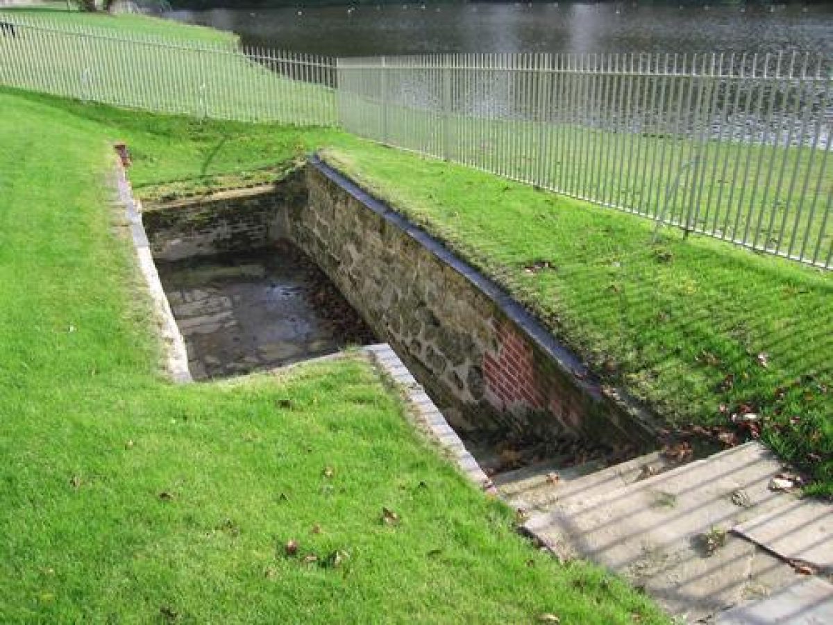
Adjacent to the north-west shore of the upper lake, archaeological excavations have revealed a structure believed to be a cold bath or plunge pool dating from c 1820 (Wessex Archaeology, 2004). Previously this was thought to be the site of a boathouse. There is reference to a boathouse situated on the opposite end of the lake in 1766, now no longer there. At the north end of the upper lake is a substantial mid-C18 castellated dam wall (listed at Grade II), adapted from a circa C17 causeway (Debois 2001), which was fully restored in 2006.
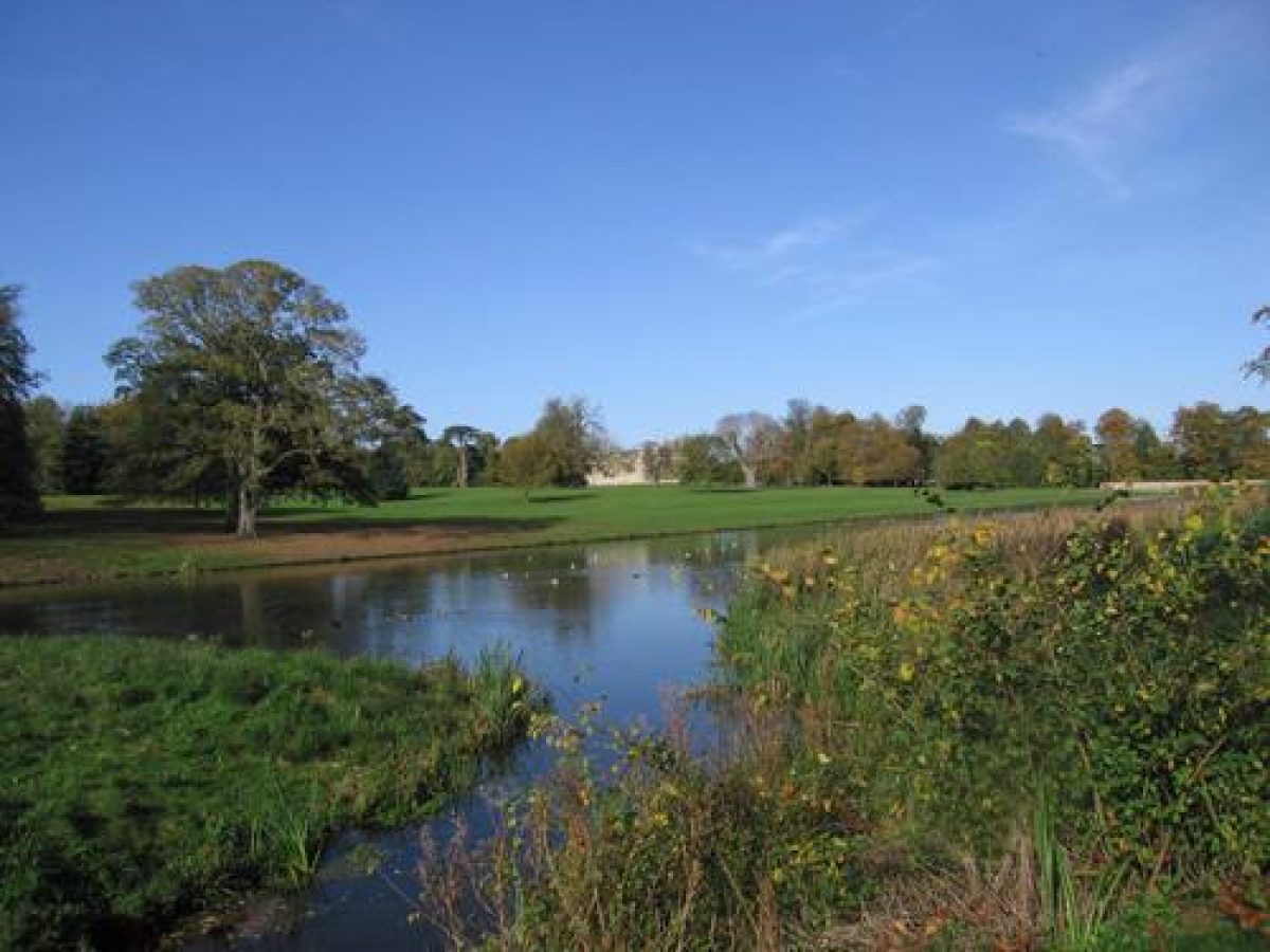
Park
The park stretches out to the north, south, and west of the House and pleasure grounds, its main feature being two serpentine-shaped lakes situated along the far south-east boundary of the site. On the eastern bank of the lakes is a plantation called The Pheasantry, which forms a shelter belt along the park wall on the south-east boundary of the site. The lakes were originally laid out as a formal canal, thus forming an important feature of the late C17 terraced gardens described above (Map of Lydiard Park, c 1700). By 1766 (Willington) the formal gardens were laid to lawn and the lakes had been given a less formal outline.
From the lawn immediately to the south-west of the House, a straight avenue, planted for half of its length (late C20), runs towards Park Copse in the far western corner of the site, creating a long vista. This avenue originates from the late C17 (Map of Lydiard Park, c 1700). Along the north-west boundary of the site, attached to Park Copse, lies Alder Plantation, through which runs a small stream. From the pleasure grounds to the west of the House, a late C18 avenue (replanted in the late C20) runs in a north-westerly direction towards Parkside Farm, passing Ash Plantation situated to its south-west.
The north-east part of the park is laid out on former glebe land exchanged between the Church and Lord Bollingbroke in 1812, enabling the replacement of the parsonage, new stables and the new separate drive to the church. By 1839, as indicated by the Tithe Map of that date, the land was used as pasture for grazing, and by the late C19 it had a number of public footpaths (OS map 1885). The southern boundary of the park is lined by a thin belt of trees with, halfway along its length, Elm Plantation, formerly called Oak Plantation (Map of Lydiard Park, c 1700). The southern part of the park immediately west of the south drive is the site of the former military hospital set up during the Second World War and removed in the 1960s.
Walled Garden
The walled flower garden (listed at Grade II) is situated c 100m north-west of the House. It has a rhomboid ground plan and its walls are constructed of red brick set in garden wall bond. The main entrance, a cast-iron gate (late C20) hung between two square brick gate piers with stone ball finials, is situated on its south side. The entrance is aligned on a short avenue planted with mixed coniferous trees introduced in the late C20, which leads south through the pleasure ground (The Avenue) to the western avenue.
The garden dates back to the early C18 when it was in use as an ornamental garden with a formal layout (Wiltshire CC 2001; Willington, 1766); by the late C19 it was used as a kitchen garden (OS 1885). An early C18 bronze sundial with the arms of the second Viscount of St John (listed at Grade II) stands in the centre of the walled garden. It was moved to its current position in 2006. It formerly stood on the terrace south of the House, where it was vandalised in 2001 and subsequently put into storage. The Ordnance Survey map published in 1885 indicates that the sundial stood in the centre of the walled garden, and following its recent restoration (early C21), it was put back in this position, forming the central feature in the newly planted garden (2013).
Selected Sources
Map Reference - Title: Andrews and Durys Map of Wiltshire - Date: 1773 - Type: MAP
Book Reference - Author: Pevsner, N (revised by Bridget Cherry) - Title: The Buildings of England: Wiltshire - Date: 1975 - Page References: 318 - Type: DESC TEXT
Article Reference - Author: John Lord- English Heritage - Title: Lydiard Park, Swindon Survey Report - Date: 2003 - Journal Title: Archaeological Investigation Report
Article Reference - Date: 19 March 1948 - Journal Title: Country Life - Volume: 103 - Page References: 578-581
Article Reference - Date: 26 March 1948 - Journal Title: Country Life - Page References: 626-629
Book Reference - Title: Victoria History of the County of Wiltshire IV - Date: 1959 - Page References: 80
Other Reference - Description: Lydiard Park Restoration Masterplan by Thamesdown Landscape Services for Swindon Council, 1992
Article Reference - Date: Autumn 1993 - Journal Title: Wiltshire Gardens Trust Journal - Volume: 28 - Page References: 7-13
Other Reference - Description: Brief archaeologiocal survey of Lydiard Park by English Heritage, 2000
Other Reference - Description: The dam wall at Lydiard. A Historical Appraisal by Debois Landscape Survey Group, 2001
Other Reference - Description: Lydiard Park Restoration and Development Plan, Swindon Borough Council
Map Reference - Title: A Map of Lydiard Park - Date: c1700 - Source: Lydiard House, Swindon
Map Reference - Title: A Survey of Lydiard Park - Date: 1766 - Source: Wiltshire and Swindon Record Office
Other Reference - Description: Archaeological survey of the walled garden, Wiltshire county Council, 2001
Map Reference - Title: Tithe Map for Lydiard Tregoze - Date: 1839 - Source: Wiltshire and Swindon Record Office
Map Reference - Title: Plan of the 302nd Station Hospital at Lydiard Park - Date: c1940 - Source: Lydiard House, Swindon
Website Reference - Author: Wessex Archaeology - Title: A Park With a Story to Tell - Date: 28/05/2013 - URL: http://www.wessexarch.co.uk/sy...
Reasons for Designation
Lydiard Park in Swindon is included on the Register of Parks and Gardens of Special Historic Interest at Grade II for the following principal reasons:
* Date and rarity: it is a good example of a mid C18 park where the layout clearly reflects its original design, and which contains archaeological evidence of its earlier, C17 formal layout;
* Representative example: it is a representative example of a mid C18 park associated with an important country house;
* Group value: the park forms a strong group with its associated heritage assets, including Lydiard House (listed at Grade I), the Church of St Mary (listed at Grade I) and the listed garden structures situated within it.
Date first registered: 01-Sep-1987
Date of most recent amendment: 13-Aug-2013
- Visitor Access, Directions & Contacts
Telephone
01793 466664Website
https://www.lydiardpark.org.ukAccess contact details
The gardens are open Tuesday to Sunday from 11 am. http://www.lydiardpark.org.uk/visit/Pages/opening-times.aspx
Directions
The site is north of the M4 at junction 16, from where it is signposted. http://www.lydiardpark.org.uk/visit/Pages/find-us.aspx
Owners
Swindon Borough Council
Civic Offices, Euclid Street, SN1 2JH
- History
The following is from the Register of Parks and Gardens of Special Historic Interest. For the most up-to-date Register entry, please visit the The National Heritage List for England (NHLE):
www.historicengland.org.uk/listing/the-list
History
Lydiard Park, formerly known as South Lydiard, Lediar, is mentioned in the Domesday Book (1086); a former manor of Alfred of Marlborough it was acquired by the Tregoze family in c.1198, and was later known as Lydiard Tregoze. In 1270 Henry III gave Robert Tregoze a royal licence to impark a nearby woodland in order to create a deer park. From 1300 until 1348 Lydiard was owned by the Grandison family, and subsequently by the Beauchamps. In 1420 the estate came to the St John family through marriage (whose main seat was at Battersea, London), and they were to hold it until the Second World War. The court met at Lydiard in 1592 during Elizabeth I's royal progress, and John St John was knighted. In 1583 it was recorded there was a park at Lydiard Tregoze owned by Nicholas St John, and much correspondence exists from 1659-64 from Johanna St John, wife of the third baronet, who was a keen amateur gardener.
During the early C17, probably during the time of Sir John St John, formal gardens including a canal were created as part of changes made to the medieval house at Lydiard (Swindon BC 2002). Sir John also laid out a series of formal avenues in the park. By c 1700 (Map of Lydiard Park), Lydiard had a park with formal avenues and woodland plantations, and a series of formal gardens including ponds and terraces. In 1742-3, under the ownership of the second Viscount St John, the south-east and south west fronts of the House were remodelled in the Palladian style. The house and parkland appear in two equestrian paintings by Stubbs in 1764-66. By 1766 many of the formal elements in the park had been removed, together with the formal gardens (Willington, 1766).
During the late C18 and early C19 the estate was neglected and largely let to tenants. In c.1830, under Henry, fifth Viscount St John, additions and reconstructions were made to the west side of the House and most of the estate was leased for hunting. The fifth Viscount also acquired some glebe land to the north of the House, which was imparked by 1885 (OS).
In 1920, and again in 1930, large parts of Lydiard Park were sold off, and the remainder of the heavily mortgaged estate fell into decline. From 1942 the park was used as a military hospital by the American Forces, and subsequently, at the end of the Second World War, as a prisoner of war camp. In 1943 the House and park were bought by the Corporation of Swindon, with a view to establishing a university. After the war the camp was used for temporary residential use until c 1960 when it was vacated and gradually removed. The Corporation of Swindon embarked on a programme of repair and restoration of the House and grounds, which were opened to the public in 1955 by Lord Lansdown.
In 1974 the Lydiard Park Management Centre was opened, and during the 1980s Lydiard Park was used as a public open space, including sports pitches, play areas, and other facilities. A lime avenue was planted to replace the elms along the eastern drive. In 1984 the Borough of Thamesdown (previously the Swindon Corporation) purchased further land which once formed part of the C18 park of Lydiard. In 1985-6 the park was designated a Country Park and a new visitor centre was built. The House is now a museum and in the late C20 a wing was added to the north-west of the house is in use as a conference centre.
In 2005 an extensive landscape restoration project began with funding from the Heritage Lottery Fund, which was completed in 2007-8. The majority of the site, including the former mansion, remains in public ownership with some parts privately owned.
- Associated People
- Features & Designations
Designations
The National Heritage List for England: Register of Parks and Gardens
- Reference: GD2246
- Grade: II
Features
- Specimen Tree
- Lake
- Icehouse
- Tree Avenue
- House (featured building)
- Description: The medieval house had additions and modifications over several centuries. The south and east fronts of the House were remodelled in the Palladian style in 1743. The house is now a museum and conference centre.
- Earliest Date:
- Parkland
- Woodland
- Farm
- Key Information
Type
Estate
Purpose
Ornamental
Principal Building
Domestic / Residential
Survival
Part: standing remains
Hectares
149
Open to the public
Yes
- References
References
- {English Heritage Register of Parks and Gardens of Special Historic Interest}, (Swindon: English Heritage, 2008) [on CD-ROM] Historic England Register of Parks and Gardens of Special Historic Interest
- Pevsner, N. and B. Cherry, {The Buildings of England: Wiltshire} (Harmondsworth: Penguin, 1975), p. 318 The Buildings of England: Wiltshire
- Crittall, Elizabeth {Victoria County History: Wiltshire, Volume 4} (London: Oxford University Press, 1959), p. 80 Victoria County History: Wiltshire, Volume 4
- Nicholas Pearson Associates {Lydiard Park Conservation Management Plan} (2001) Lydiard Park Conservation Management Plan
- Related Documents
-
CLS 1/77/330
Restoration and Development Plan - Hard copy
Nicholas Pearson Associates - 2003
-
CLS 1/77/330