Introduction
Llantrithyd Place has the well-preserved structure of an important 16th-century garden and of a detached mid-17th-century deer park, belonging to prominent Glamorgan families. The garden is of some complexity, with terraces, ponds and walks, including an unusually sophisticated raised walk up to a look-out mount or gazebo. The walled deer park is exceptionally complete.
There is a description of the site by G.T. Clark dating from 1867. This reads ‘the position of the house, on ground sloping towards the south was favourable for the construction of terraced gardens, and full advantage seems to have been taken of this. The ground to the north, falling towards the house, is retained by a wall and terrace towards the west. West again, of the house...the middle platform is retained by another wall...'.
Recent survey of the land around the house has found that the garden structure had remained intact, albeit masked by undergrowth. In part due to the abandonment of the site and ensuing neglect, many significant features of the 16th and early-17th century formal garden have survived. These include terraces, walks, ponds and walled compartments. There are also four bee boles which have been found in stone wall below the churchyard, in the area of the former upper terrace. These are likely to date from the same period.
The house was on a platform above two walled terraces. In the valley bottom were rectilinear fishponds linked by the canalised stream. A raised walkway ran over a bridge to the gardens from the north-east corner of the house. The path ran to a look-out platform on the far side of the valley. The raised walkway is described as ‘an advanced feature for a provincial garden' and has been likened to the cloister walk at Aberglasney. The two estates were linked by marriage, which may explain the similarity.
The gardens were clearly the result of considerable investment. Accounts of the Aubrey family refer to the purchase of statues, nectarine and cherry trees in the 1620s and 1630s, and the leading of the summerhouse in 1635. The impression is given of a fashionable and sophisticated garden.
The next clear documentary evidence regarding the site is a survey by John Stone in 1788. This survey notes two kitchen gardens, two other gardens with heated greenhouses, walled gardens with trained fruit trees and a walled orchard. Not long after this date the deterioration of the gardens must have begun.
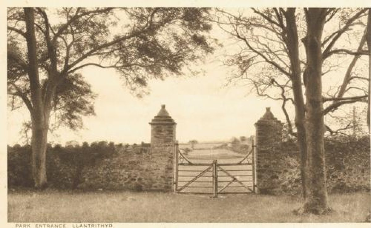
There is a large and substantially intact deer park to the north and east of the gardens. The park is thought to have been created some time after 1660 by Sir John Aubrey. It is not shown on a survey of 1643, but is noted on a map of 1675 when it was stocked with fallow deer. The site was disparked around 1900 and re-stocked in 1990. The perimeter walls and internal paddocks from the 17th century are still in use today.
- Visitor Access, Directions & Contacts
Telephone
01443 336000
- History
The house was built by John Basset in the early-16th century. Later in that century it passed by marriage to the Mansel family. It is thought that John Basset began the creation of the gardens, but Anthony Mansel is credited with the creation of the walled and terraced gardens and the fishponds.
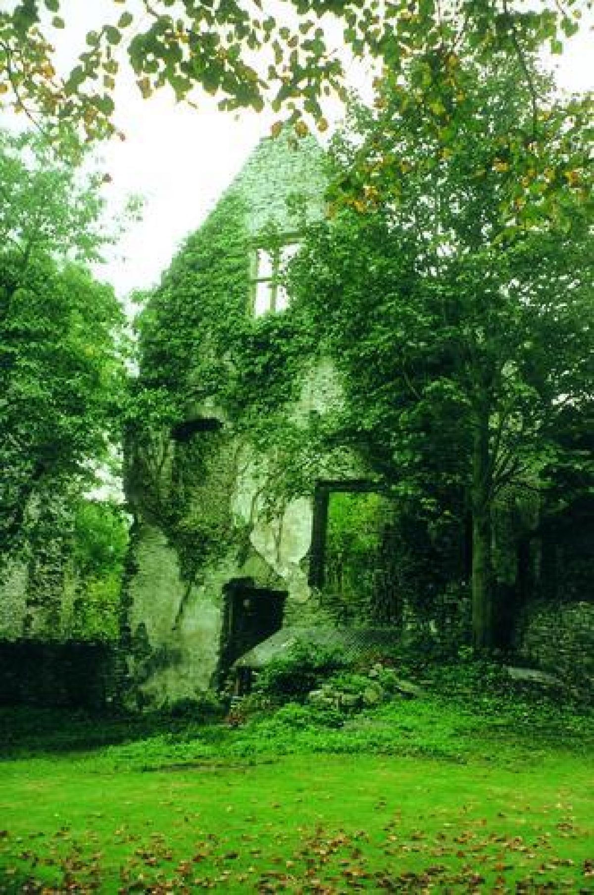
In 1586, the marriage of Mary Mansel with Thomas Aubrey passed the house to the Aubreys, for whom it was the main residence. They made additions to the house in the early-17th century, but abandoned the site in the late-18th century, when their main residence was in Buckinghamshire. The house fell into ruin.
Period
- Post Medieval (1540 to 1901)
- Tudor (1485-1603)
- Features & Designations
Designations
CADW Register of Landscapes Parks and Gardens of Special Historic Interest in Wales
- Reference: PGW(Gm)43(GLA)
- Grade: II*
CADW Register of Listed Buildings in Wales
- Reference: Llantrithyd Place
- Grade: II
Features
- House (featured building)
- Description: The house is now a ruin, built of local lias linestone with sandstone dressings. It has three ranges, but only parts stand to their full height.
- Earliest Date:
- Latest Date:
- Park Wall
- Description: There is a wall enclosing the deer park, occupying 32 hectares. The wall is made of mortared rubble stone, and dates from the mid-17th century.
- Earliest Date:
- Latest Date:
- Pond
- Description: Pond with stone walls and ramped entrances.
- Stream
- Description: Canalised stream.
- Cascade
- Description: Small cascade.
- Garden Terrace
- Description: There are two terraces.
- Mount
- Description: Raised viewpoint at the end of the mount.
- Orchard
- Description: Former orchard.
- Bee Bole
- Description: There are four bee boles below the churchyard and within the upper garden terrace.
- Key Information
Type
Garden
Purpose
Ornamental
Principal Building
Heritage Site
Period
Post Medieval (1540 to 1901)
Survival
Extant
Hectares
30
Open to the public
Yes
Civil Parish
Llancarfan
- References
References
- CADW, {Register of Landscapes, Parks and Gardens of Special Historic Interest in Wales: Glamorgan} (Cardiff: CADW, 2000) 254 Register of Landscapes, Parks and Gardens of Special Historic Interest in Wales: Glamorgan
- Newman, J., {The Buildings of Wales: Glamorgan} (London: Penguin, 1995) 404-5 The Buildings of Wales: Glamorgan
- Stone, J., {Survey of Llantrithyd Place} (1788) Survey of Llantrithyd Place
- Hilary M. Thomas {Historic Gardens of the Vale of Glamorgan} (Welsh Historic Gardens Trust, 2007) 145 Historic Gardens of the Vale of Glamorgan