Introduction
Lanhydrock is a 17th-century deer park and woodland of around 137 hectares, with 19th- and 20th-century gardens of around 8 hectares. The gatehouse and north wing of the house survive from the 17th century, but the main house was restored in 1881. The garden has a collection of camellias, magnolias and rhododendrons, with extensive woods and parkland running to the River Fowey.
Terrain
The site is undulating, with a valley extending south-east from the house.www.historicengland.org.uk/listing/the-list
Gardens of mid 17th century origin which were further developed in the 19th and 20th centuries, together with a mid 17th century deer park which was extensively landscaped in the early and mid 19th century.
DESCRIPTION
LOCATION, AREA, BOUNDARIES, LANDFORM, SETTING
Lanhydrock is situated c 2.5km south-east of Bodmin, from which it is separated by the A30 road. The c 145ha site comprises some 8ha of gardens and pleasure grounds, and c 137ha of parkland and associated plantations and carriage drives. The site is bounded to the north-east by a minor road which leads south-east from Bodmin to Respryn Bridge; a further minor road leading from Newton south-west to Maudlin forms the east boundary of the site. To the south-east the boundary follows the east bank of the River Fowey as far as Restormel Manor where it turns west to encompass Restormel Castle (scheduled ancient monument). To the south-west the site adjoins agricultural land, some of which formed part of the mid C17 deer park; archaeological remains of the C17 park boundary survive (LUC 1995) corresponding to the extent of the park shown on the Lanhydrock Atlas of c 1696. The north-west boundary of the site is formed by a further minor road which joins the B3268 road at the western corner of the site. The site is undulating, with a valley extending south-east from the house through the park towards the River Fowey which flows from north to south through a wide valley c 1.4km east of the house. The ground rises to the north, south, and west of the house, affording extensive views from the gardens and north-west park north-east to Bodmin Moor, and east across the Fowey valley. There are also significant views south from the park to Restormel Castle c 2.5km south-east of the house. This medieval castle was exploited as a picturesque feature in views from Lanhydrock in the late C18.
ENTRANCES AND APPROACHES
Lanhydrock is today (2000) approached from a minor road which crosses the site from east to west, linking the minor roads forming the north-east and north-west boundaries, at a point c 480m north of the house. Simple quadrant walls flank the entrance from the road while to the south-east of the entrance stands a late C20 visitors' centre. The tarmac drive with cobbled gutters extends c 500m south through the park to reach the gatehouse east of the house. An approach on the line of this drive is shown on the Lanhydrock Atlas (c 1696). The drive extends to the north of the minor road from which the site is now entered, passing c 560m north-east through ornamental woodland to reach the Double Lodges (listed grade II*). The southern end of this section of the north drive has been adapted in the late C20 as a visitors' parking area. The entrance comprises a symmetrical pair of two-storey granite lodges flanking a central gate supported on granite piers with pedestrian gates to each side. Each lodge comprises two blocks, the inner being square on plan under a pyramid roof; the outer blocks are of similar design. The lodges were originally constructed in the C18, and were extended in the mid C19; the north drive is shown in its present form on the 1" OS map of 1813, and the Tithe map of 1843.
The principal C17 approach to the house was from the minor road forming the south-east boundary at Newton. The entrance is flanked by a pair of granite piers (listed grade I) dated 1657 and bearing the initials of John and Lucy Robartes (inscription). The piers are surmounted by obelisks with ball finials, and support a single early C20 timber gate. Flanking quadrant walls c 3m high contain a pedestrian arch closed by C20 timber gates each side of the carriage entrance. Within the park and to the south-west of the entrance is a late C19 two-storey stone lodge (listed grade II). Beyond the entrance the tarmac drive extends c 960m west through a double avenue of beech, to reach the gatehouse east of the house. The avenue was originally planted by John, second Baron Robartes in 1648 and comprised a single avenue of sycamore; some specimens from this avenue survive. A double avenue of beech was planted in 1827 (guidebook 1995). There are views south across the park towards Restormel Castle from the avenue and east drive.
A mid C19 extension to the principal, east drive extends to the east of the minor road forming the north-east boundary of the site and leads to Bodmin Parkway or Bodmin Road Station. This drive is entered through a single timber carriage gate supported on granite piers and flanked by a pair of single pedestrian gates c 270m east of the Newton gate. A late C19 two-storey stone lodge stands to the south-east of the entrance. The drive, which is today a footpath, leads c 550m north-east through a belt of mixed ornamental planting including many specimen conifers; this planting is bounded to the north-west by a minor road, and to the south-east by the River Fowey, of which there are glimpsed views. Passing south of a late C20 pond, the drive turns south-east to cross the river on a mid C19 single-arched granite bridge. The drive continues south-east for c 200m before passing beneath the railway and turning north-east to approach the station. The Station Drive was constructed c 1860 to connect the house with a proposed private halt on a branch line leading to Bodmin; this line was not constructed and the drive was adapted in 1883 to lead to the station on the main line. The line of the drive is shown on the 1881 OS map, while the lodge and bridge are shown on the map of 1907.
A further drive approaches the site from the B3268 road to the west, where the entrance is marked by a single timber carriage gate supported by a pair of granite piers, flanked to each side by a single pedestrian gate. A late C19 two-storey granite lodge with hipped slate roofs, known as Treffry Lodge, stands immediately north-east of the entrance. The tarmac drive extends c 400m along a ridge of high ground running through the north-west park, before sweeping south-east to join the north drive c 270m north of the house.
A drive, today surviving in part as a footpath and in part as a public road, connects Lanhydrock to Restormel to the south. A track leads c 960m south-east from the house through Great Wood. Crossing Newton Lane, the track passes through a timber gate supported by a pair of simple granite piers and continues south-east through woodland for c 200m before emerging into agricultural land. The drive extends c 1km south-east above and to the south-west of the River Fowey. The meadows between the drive and the river retain scattered mature specimen trees, while there are views north and south along the river valley, Restormel Castle forming a picturesque feature in views to the south. The drive passes to the north-east of the wooded slope below the Castle before sweeping south to reach Restormel Farm; from this point the drive continues as a public road leading c 1.25km south to Lostwithiel. The Restormel drive was established by 1813 when it and its associated ornamental planting is shown on the 1" OS map. In the late C18 or early C19 Anna Maria Agar took a lease of the Restormel estate from the Duchy of Cornwall, and in 1827 the picturesque quality of the valley and Castle was noted by Ackerman (LUC 1995).
PRINCIPAL BUILDING
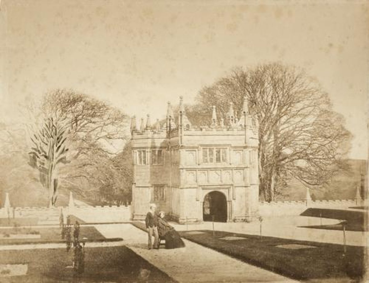
Lanhydrock (listed grade I) stands on an artificially levelled site partly cut into a north-east-facing slope towards the south-west corner of the site. The house is U-shaped on plan with a courtyard open to the east; a further service court adjoins the house to the south. As originally constructed, the house enclosed a central courtyard but the east wing, which is shown in a view in the Lanhydrock Atlas (c 1696), was demolished by George Hunt c 1780 (guidebook 1995). The house is approached through a two-storey granite gatehouse (listed grade I) which stands c 80m east of the house. Constructed in 1651 for John and Lucy Robartes, the gatehouse comprises a pair of octagonal towers surmounted by crenellated parapets and obelisks with ball finials, linked by a carriage arch set below an upper room lit by mullion windows. The main house is constructed in granite ashlar and comprises two storeys lit by wide mullion windows under hipped slate roofs set behind crenellated parapets. A two-storey stone porch is placed centrally on the east facade, on an axis with the gatehouse, while the north wing contains in its upper floor the Gallery with important mid C17 plasterwork. The service quarters to the south-west of the main house are constructed in rubble stone with granite dressings. To the south-east and south of the house are a range of mid and late C19 coach houses and service buildings (all listed grade II*), some of which were constructed to the designs of George Gilbert Scott.
The present house at Lanhydrock was begun c 1620 by Sir Richard Robartes, replacing a medieval monastic barton which probably stood c 50m north-west. The house remained incomplete at Sir Richard's death in 1634, and was completed by his son John (1606-85), later first Earl of Radnor. Under the third Earl in the early C18, the house was largely unoccupied and neglected, and following his inheritance in 1758, George Hunt undertook a programme of renovation which included the demolition of the east wing. Further improvements were made under the direction of George Gilbert Scott in the mid C19. The house was, with the exception of the north wing containing the Gallery, and the porch, destroyed by fire in 1881. It was rebuilt in 1882-5, largely following the original plan but with the addition of modern facilities and new service quarters to the south-west, under Richard Coad, a local architect who had earlier assisted Scott at Lanhydrock (ibid).
GARDENS AND PLEASURE GROUNDS
Formal garden are situated to the north and east of the house, while informal pleasure grounds extend to the north-west, west, and south-west of the house.
The formal gardens comprise a symmetrical terraced parterre of six beds in the Front Court to the east of the house, and lawns and a further parterre to the north of the house. The Front Court is divided by the gravelled drive which extends west from the gatehouse to the carriage court immediately east of the house. Enclosed to the north, west, and south by wings of the house, the carriage court is laid out with a central circular lawn, while the walls of the house are planted with mature evergreen magnolias. The Front Court is enclosed and retained to the north, east, and south by crenellated granite walls which are broken by piers surmounted by obelisks with ball finials (all listed grade II*); the walls were designed by George Gilbert Scott in 1857. Terraced lawns rise in three levels from the gatehouse to the house, with shallow flights of stone steps connecting each level adjacent to the north and south boundary walls. Further steps ascend north and south from the central walk to the eastern pair of lawns. These steps are flanked by a pair of late C17 bronze urns (listed grade II), part of a set of eight similar urns formerly in the gardens at the Chateau de Bagatelle, Paris, which were introduced into the gardens at Lanhydrock by the seventh Viscount Clifden c 1930. Each lawn is laid out with a series of geometric flower beds flanked by four clipped Irish yews. The beds on the middle lawns are centred on a further pair of bronze urns (listed grade II). The formal garden to the east of the house was laid out in 1857 by George Gilbert Scott; the original scheme of geometric beds was simplified in the 1930s. Scott's garden replaced lawns which, in the C18, had taken the place of an enclosed forecourt with a central flagged walk, with a walled garden to the north; these are shown on a C17 view of the house, and in an early C18 sketch by Edmund Prideaux (LUC 1995; Architect Hist 1964; NMR).
To the north of the house are two further terraced lawns. The eastern or lower is laid out with a complex geometric box-edged parterre centred on a further bronze urn (listed grade II) and planted with seasonal subjects and enclosed by low yew hedges. The upper or western lawn is laid out with a symmetrical group of five beds planted with seasonal subjects. Stone steps connect the terraces to the north and south, while further stone steps ascend west to a terrace walk extending from north to south below a mixed border retained by a low stone wall and a high crenellated stone wall which retains the churchyard to the west. A gothic-arched stone arbour set into the retaining wall terminates a gravel walk leading west below the north facade of the house, while stone steps ascend west to the parish church of St Hydroc (listed grade I) which stands immediately north-west of the house. The formal garden north of the house was laid out by George Gilbert Scott in 1857 on the site of the C17 bowling green recorded on the Lanhydrock Atlas (c 1696).
A low mid C19 wrought-iron gate leads north from the formal garden to the informal pleasure grounds. To the north and north-east of the house is an area of lawns planted with specimen trees and shrubs, including, adjacent to the tennis lawn north-east of the house, trees planted by Lord Rosebery and W E Gladstone. A gravel walk leads c 50m north-west to a C19 arch-topped wrought-iron gate under an arched overthrow set in a wrought-iron fence with spear-headed rails; this fence was erected c 1860 by Lord Robartes to enclose the pleasure grounds from the park. The gate leads north-west to a network of walks which pass through an area of trees underplanted with specimen magnolias. Laid out c 1860 with walks and serpentine beds on the site of the C17 walled garden (Lanhydrock Atlas, c 1696), this area became overgrown in the early C20; in 1933 the seventh Viscount Clifden began to plant magnolias. To the south a small stream flows from west to east and is planted with moisture-loving plants and a collection of camellias. Some 130m north-west of the house a flight of stone steps ascends to a circular garden enclosed by yew hedges. The garden is divided into quarters by a gravel walk running from east to west, and a grass walk running from north to south. Each quarter is laid out with borders planted with herbaceous subjects. To the north the Herbaceous Circle is overlooked by the south facade of a C19 barn (listed grade II) which incorporates architectural fragments removed from the church in the mid C19. The southern half of the Herbaceous Circle was laid out by Lady Clifden before 1914 while the northern half, which was occupied by a greenhouse and potting shed, was laid out in 1972 (guidebook 1988). To the west of the Herbaceous Circle a gravel walk leads c 30m west to join the Broad Path, a walk which leads c 100m south parallel to the western boundary of the pleasure grounds which is here formed by a stone wall. To the east of the Broad Path is a further glade of specimen magnolias, while c 130m west of the house the walk passes to the south of the Holy Well (listed grade II), a mid C19 gothic, gabled stone structure enclosing a spring. Some 10m south-east of the Holy Well stands Joseph's Cottage (listed grade II), a two-storey stone and cob thatched-roofed gardener's cottage. Of C18 origin, the cottage was remodelled and given picturesque details in the mid C19, and is named after its last occupant, Joseph Berry (d 1885) (guidebook 1995).
South of the cottage a walk ascends the north-facing slope through a late C20 wrought-iron tunnel covered by trained magnolias. This walk connects the western end of two terrace walks which traverse the slope, and which converge c 80m south of the house adjacent to a pair of mid C19 wrought-iron gates which lead from the pleasure grounds to the woodland garden. The grass slope between the two terrace walks is planted with mature specimen trees, rhododendrons, and other ornamental shrubs. Adjacent and to the south-west of the gates stands a late C20 cob, timber, and thatch summerhouse. Some 50m south-east of the gates leading to the woodland garden, the Treffry Cross (listed grade II), a pre-Conquest granite wheel-headed cross set on a C19 granite shaft, stands on Scotland Hill, an eminence planted with specimen Irish yews. The cross was placed in its present position in 1890, having previously stood at Treffry crossroads at the western corner of the site (guidebook 1995). A large subterranean reservoir was constructed in this area following the fire of 1881. The Top Path extends c 300m south-east through the mature woodland on the north-facing slope to the south of the house, and joins the drive leading to the kitchen garden and the Restormel drive at a point c 350m south-east of the house; subsidiary walks descend the slope connecting the transverse walks and drives. The predominantly deciduous woodland is interspersed with late C19 specimen conifers, and is underplanted with rhododendrons, camellias, and other ornamental shrubs.
The pleasure grounds to the west and south-west of the house were developed from the mid C19 when Lord Robartes enclosed the area to the west and north-west of the house from the park. The Lanhydrock Atlas (c 1696) indicates that the C17 gardens were concentrated to the north and north-east of the house, with the park running up to the stables court to the south.
PARK
The park is situated on undulating ground to the west, north, east, and south-east of the house, and remains pasture with scattered specimen deciduous trees and groups of trees. A valley, known as South Park, descends south-east from the house towards the River Fowey, with The Round, an irregularly shaped plantation containing a pool c 750m south-east of the house. South Park is enclosed to the north by the mid C17 avenue, which separates it from Lower Park on a south- and south-east-facing slope c 400m north-east of the house. Higher Park is situated on a ridge of high ground north-west of the house. To the north-west, north, and north-east the park is bounded by plantations which screen it from adjacent public roads, while a more substantial area of woodland, Great Wood, extends south-east of the house on a north-east-facing slope above the park. Great Wood is separated from the park by a sunk fence, while the Lady's Walk extends south-east within the Wood and parallel to its boundary with the park. Great Wood corresponds to a smaller area of unfenced woodland which is shown within the park on the Lanhydrock Atlas (1696). Some 270m north of the house the boundary plantation known as The Belts corresponds to the late C17 Wilderness which was separated from the gardens by the 'New Orchard' on the south-facing slope north of the house (Lanhydrock Atlas, c 1696). On high ground c 560m north-east of the house the early C20 stables (listed grade II) comprise an approximately U-shaped structure with east and west wings extending from the north wing to enclose part of the stable yard to the south. The yard is enclosed to the south by stone walls, and today has a hard surface for parking. The stables were constructed in 1905 for the sixth Viscount Clifden, and were converted to form offices in the late C20. Two swimming pools are set into the south-east-facing slope some 375m south-east of the stables and separated from them by a plantation. The northern pool is approximately rectangular on plan, and has retaining walls constructed in coursed granite and quartz rubble; it appears to be of early C19 construction. The southern pool is also rectangular on plan; of early C20 construction, it is lined in concrete.
The park was first enclosed by John, second Baron Robartes c 1657. This park comprised land to the south of the avenue which had been planted in 1648, including Great Wood and land to the south-west which is today (2000) in agricultural use, together with Brownqueen Wood to the south-east of Newton Lane. By 1696 the park had been reduced in area, with land to the west of the house and to the south-west of Great Wood being enclosed for cultivation; Kitchen's Plan of the County of Cornwall (1749) indicates that Brownqueen Wood had also been disparked. By the end of the C18 deer were no longer kept, and the former deer park was incorporated into the ornamental landscape. In the late C18 George Hunt extended the park to include land to the north of the avenue and to the west of the house, while Lower Park was extended to the north-east and south-east in the mid C19 (Tithe map, 1843). The park had reached its present extent by 1881 (OS), and much of the present plantations in the north, north-west, and north-east areas of the site date from the mid and late C19 when Lord Robartes improved the estate with picturesque woods formed from his 'Lanhydrock mixture' of beech, Scots pine, and silver fir (guidebook 1995). The park and plantations have been subject to a restoration programme by the National Trust following storm damage in 1990.
KITCHEN GARDEN
The kitchen garden is situated c 530m south-south-east of the house, and is screened from the house and park by Great Wood. Rectangular on plan, the garden is enclosed by slatestone rubble walls (listed grade II) with slate coping and granite quoins. The garden is divided by a transverse wall running from east to west which is pierced by a brick arch, while a two-storey gardener's cottage is attached to the west wall (listed grade II). The cottage is constructed in granite rubble with brick dressings under a hipped slate roof. A tool shed is built onto the outer side of the north wall, and a brick segmental arch in the north wall closed by timber doors provides access to the garden. A further gateway to the north of the gardener's house is closed by a wrought-iron gate. A yew hedge running south parallel to the west wall divides the northern compartment of the garden which is today (2000) used as a nursery.
The kitchen garden was constructed in the mid or late C19 and replaced an earlier kitchen garden to the north-west of the house which is shown on the Lanhydrock Atlas (c 1696).
OTHER LAND
The Cricket Ground c 600m north-east of the house is included in the site here registered. The ground is approximately triangular on plan, and is bounded to the north-west by ornamental planting adjacent to the north drive, and to the north-east by Lodge Plantation. To the south it adjoins the minor road which passes from east to west across the site. A timber pavilion stands on the western side of the ground. The Cricket Ground was laid out in 1901 as a coming of age present for Thomas Agar Robartes (1880-1915).
REFERENCES
W Borlase, The Natural History of Cornwall (1758), p 288
C S Gilbert, Historical Survey of Cornwall ii, (1820), p 636
R. Ackerman, Repository of Arts ... 10, (1827), pl 8
W W J Gendall, Views of Country Seats ... I, (1830), p 19
J Britton and E W Brayley, Devonshire and Cornwall Illustrated (1832), p 27
Country Life, 14 (19 December 1903), pp 890-896; 147 (5 March 1970), pp 540-544; 163 (16 February 1978), pp 383-385; (23 February 1978), pp 458-460
Lady Rockley, Historic Gardens in England (1938), p 162
Architect Hist 7, (1964), pp 31, 75
N Pevsner and E Radcliffe, The Buildings of England: Cornwall (2nd edn 1970), pp 89-90
J Roy Instit Cornwall (1988), pp 221-252
Lanhydrock Storm Damage 1990, (National Trust Report 1991)
Lanhydrock: survey and management, recommendations for the designed historic landscape (Land Use Consultants 1995)
Lanhydrock Estate, guidebook, (National Trust 1996)
D E Pett, The Parks and Gardens of Cornwall (1998), pp 189-190
Lanhydrock, Cornwall, guidebook, (National Trust 1995, revised edn 1999)
Lanhydrock, Cornwall - Parks and Gardens, guidebook (National Trust 1999)
Maps
J Gascoyne, Lanhydrock Atlas, c 1696 (Cornwall Record Office)
Kitchin, Plan of the County of Cornwall, 1749 (Cornwall Record Office)
Tithe map for Lanhydrock parish, 1843 (TM109), (Cornwall Record Office)
OS Old Series 1" to 1 mile, published 1805
OS 25" to 1 mile: 1st edition published 1881
Illustrations
Bird's-eye view of Lanhydrock from the north-east, mid or late C17 (National Monuments Record (NMR))
E Prideaux, Lanhitherock near Bodmyn in Cornwall, 1727 (NMR)
Archival items
The Clifden family collection, including estate plans, records and accounts, and personal and estate correspondence, is held at the Cornwall Record Office (DD.CL).
Photographs, mid and late C19, C20 (National Trust Collection; NMR)
Description written: January 2001
Edited: October 2001
- Visitor Access, Directions & Contacts
Telephone
441208265950Access contact details
The gardens are open all year round, but access to the house, shop and plant centre is from February/March to November only. Please see: http://www.nationaltrust.org.uk/place-pages/198/pages/opening-times-calendar or telephone 01 208 265950
Directions
The site is 2.5 miles south-east of Bodmin.
Owners
The National Trust
Heelis, Kemble Drive, Swindon, SN2 2NA
- History
The following is from the Register of Parks and Gardens of Special Historic Interest. For the most up-to-date Register entry, please visit the The National Heritage List for England (NHLE):
www.historicengland.org.uk/listing/the-list
HISTORIC DEVELOPMENT
In the medieval period Lanhydrock was a grange belonging to the Priory of St Petroc at Bodmin. At the Dissolution the property passed to the Glynn family, and subsequently, through marriage, to the Lyttelton family. In 1577 a further marriage settlement conveyed it to Thomas Trenance, in whose family it remained until 1620 when it was sold to Sir Richard Robartes of Truro. Sir Richard was created Baron Robartes of Truro in 1625, and began to rebuild the monastic grange; this work was completed by his son John, second Lord Robartes, who inherited the estate in 1634. Lord Robartes, who in 1630 married Lucy Rich, daughter of the Earl of Warwick, was active in politics and garrisoned Lanhydrock for Parliament during the Civil War and fought at Edge Hill and Newbury. The house was taken by Royalist forces in 1644, but after 1649 it was recovered by Robartes, who spent much time there in retirement from politics. In 1679 he was created Earl of Radnor and Viscount Bodmin by Charles II.
The first Earl's eldest son, Robert, Viscount Bodmin died in 1682, three years before his father; at the first Earl's death the estate passed to his grandson, Charles Bodville Robartes, second Earl of Radnor. Through his wife the second Earl inherited Wimpole Hall, Cambridgeshire in 1693; Radnor laid out extensive formal gardens at Wimpole, but in 1710 financial pressures forced him to sell the property. The second Earl died without issue in 1723, and was succeeded as third Earl by his nephew Henry (about 1695-1741). The third Earl also died childless, leaving the title to a distant cousin and the Cornish estates to his sister Mary, the wife of Thomas Hunt of Great Mollington, Cheshire. Their eldest son, George (about 1720-1798), moved to Lanhydrock and renovated the house which had been empty since 1723. George Hunt, who served as MP for Bodmin from 1753, remained unmarried, and at his death in 1798 left the property to his niece, Anna Maria Hunt. Anna Maria married Charles Agar, youngest son of the first Viscount Clifden in 1804, but her husband died only seven years later, leaving her to manage the estate until their son, Thomas, came of age in 1829. Thomas Agar assumed the additional name of Robartes in 1822, and between 1847 and 1868 served as MP for East Cornwall; he was created Baron Robartes of Lanhydrock and Truro in 1869. At Lanhydrock, Lord Robartes developed the park and surrounding estate with plantations and connecting carriage drives, while the house was altered by George Gilbert Scott (1811-1878) in 1857.
In 1881 the house was devastated by fire; Lady Robartes died within days from shock, and Lord Robartes died the following year. Their son Thomas, second Baron Robartes, rebuilt the house to designs produced by Richard Coad. In 1894 Lord Robartes bought back the Wimpole estate which had been sold in 1710; this was settled on his second son, Gerald, in 1906. On the death of his cousin in 1899, Lord Robartes became sixth Viscount Clifden.
Lord Clifden's eldest son was killed during the First World War, and at his death in 1930 Lanhydrock passed to his second son, who sold Wimpole in 1936. The seventh Viscount gave the house, park, and woodlands to the National Trust in 1953, in whose ownership the property remains (2000).
- Associated People
- Features & Designations
Designations
The National Heritage List for England: Register of Parks and Gardens
- Reference: GD1417
- Grade: II*
Features
- House (featured building)
- Description: The earlier house was destroyed by fire in 1881 and the new one was built by Richard Coad.
- Earliest Date:
- Plantation
- Drive
- Description: Carriage drive
- River
- Description: River Fowey
- Woodland garden
- Gatehouse
- Parkland
- Deer Park
- d
- Key Information
Type
Estate
Purpose
Ornamental
Principal Building
Domestic / Residential
Survival
Extant
Hectares
145
Open to the public
Yes
Civil Parish
Lanhydrock
- References
References
- {English Heritage Register of Parks and Gardens of Special Historic Interest} (Swindon: English Heritage 2008) [on CD-ROM] Historic England Register of Parks and Gardens of Special Historic Interest
- Pevsner, N and Radcliffe, E {The Buildings of England: Cornwall} (Harmondsworth: Penguin, 1970) pp 89-90 The Buildings of England: Cornwall
- Pett, D E {The Parks and Gardens of Cornwall} (1998) pp 189-190 The Parks and Gardens of Cornwall
- Land Use Consultants {Lanhydrock Revised Historic Survey and Conservation Plan} (1993) Lanhydrock Revised Historic Survey and Conservation Plan
- Related Documents
-
CLS 1/339
Survey and Management Recommendations for the Designed Historic Landscape - Digital copy
LUC - 1995
-
CLS 1/339