Introduction
Tregrehan has 19th- and 20th-century pleasure grounds, woodland gardens and pinetum of 8 hectares. These are set within a larger agricultural estate.
Terrain
The site occupies a ridge of high ground which extends south from the northern boundary to the site of the house; from the house the ground falls to the south towards the A390 road, and west and east to small streams.www.historicengland.org.uk/listing/the-list
Mid 19th century gardens and pleasure grounds designed by W A Nesfield together with significant 19th and 20th century plant collections, set in 18th and 19th century parkland.
DESCRIPTIONLOCATION, AREA, BOUNDARIES, LANDFORM, SETTING
Tregrehan is situated c 4km east of St Austell and c 1km west of the hamlet of St Blazey Gate, to the north of the A390 St Austell Road. The c 45ha site comprises some 8ha of formal gardens and informal pleasure grounds, and c 37ha of parkland. The site is bounded to the south by the A390 St Austell Road which leads east from St Austell to Lostwithiel, while to the west the boundary is formed by a minor road which leads north from the A390 road to Tregrehan Mills. To the north-west the site adjoins domestic properties which abut this minor road, and to the north the boundary is formed by a further minor road which leads east from Tregrehan Mills to Ashcombe. To the north-east a footpath and track leading south-east to St Blazey Gate forms the boundary of the site; the 1" OS map of 1810 shows this path as a road. To the east the site adjoins the gardens and grounds of properties in St Blazey Gate. An avenue and associated drive extend south from the site beyond the A390 road towards Carlyon Bay. The site occupies a ridge of high ground which extends south from the northern boundary to the site of the house; from the house the ground falls to the south towards the A390 road, and west and east to small streams which flow in valleys near the west and east boundaries of the site. There are extensive views south, west, and east from the house across the park, those to the south extending to Carlyon Bay. To the east, the spire of the mid C19 church at St Blazey Gate acts as an eyecatcher from the pleasure grounds.
ENTRANCES AND APPROACHES
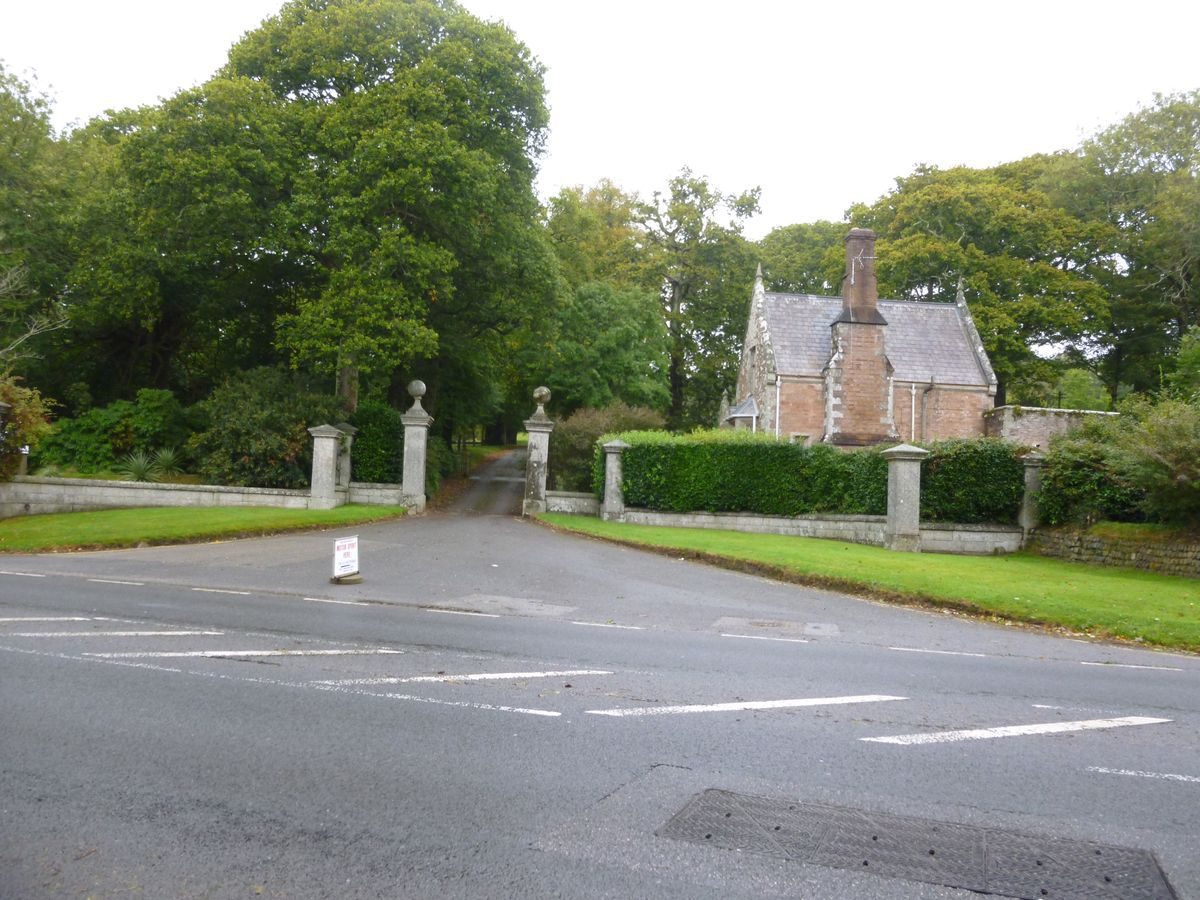
Tregrehan is approached from the A390 St Austell Road to the south at a point c 800m south-west of St Blazey Gate. The entrance comprises a series of square-section granite piers surmounted by pyramid caps which are linked by low granite quadrant walls; these walls formerly supported iron railings. The quadrant walls flank a pair of tall, square-section granite piers surmounted by ball finials which adjoin the drive. Within the site and immediately to the north-east of the entrance stands a two-storey Tudor-gothic stone lodge (listed grade II); this was erected c 1853 to the design of Colling (Pring Assocs 1992). The tarmac drive extends c 200m north-west of the entrance through an avenue of late C19 limes. Ascending gently through the park, the drive sweeps north-west and north-east before turning east for c 120m to pass through groups of rhododendrons and evergreen shrubs to reach the forecourt below the west facade of the house. The gravelled forecourt is entered through a pair of C20 timber gates supported by a pair of square-section granite piers surmounted by heraldic lions, and is enclosed to the west by granite walls and balustrades. To the north and south the forecourt is enclosed by yew hedges, while a central quatrefoil-shaped lawn is ornamented with a carved stone lion couchant. The carriage turn is surrounded to the west, south, and north by panels of lawn, while stone steps ascend to the north to reach the service quarters and stables to the north-west of the house, and a gate leads south to the formal garden terraces. The forecourt was laid out to a design prepared by W A Nesfield for Edward Carlyon in 1843 (Carlyon papers); the south drive probably formed part of Nesfield's scheme. The present south drive replaced an earlier approach from the south which comprised an avenue leading north through the park which turned sharply east and north to approach the house on the axis of the south facade. This approach is shown on the 1736 estate plan but had been removed and replaced by a drive from the south-east by 1810 (OS); the south-east drive is also shown on the Tithe map (1839), but had in turn been removed by 1880 (OS).
A further drive leads north from the south drive c 50m west of the house. This drive is today (2000) a track which leads c 370m north to the minor road which forms the northern boundary of the site. An approach from the north is shown on the 1736 estate plan, the 1" OS map (1810), and the Tithe map (1839); this drive was realigned in the mid C19 when the public road to the north of the pleasure grounds was closed. An approach from the minor road forming the western boundary of the site is shown on the OS map of 1810 and the Tithe map of 1839 but had been removed by 1880 (OS), although traces survive as a track today (2000).
To the south of the A390 St Austell Road and opposite the principal entrance to Tregrehan, a drive leads c 950m south-east and south to Carlyon Bay and Crinnis. The northern 375m of this drive survives as a footpath passing through the remains of a late C19 avenue of Wellingtonia and Scots pines; the southern 575m to the south of Par Moor Road is today (2000) a public road which passes through an early C20 avenue of cypresses. This drive is terminated to the south by a mid C19 gothic stone arch flanked by turrets which carries the Penzance to Exeter railway line over the road. The extension of the south drive was formed in the mid or late C19 to provide access to the Carlyons' mines at Crinnis (Pring Assocs 1992).
PRINCIPAL BUILDING
Tregrehan (listed grade II) stands on a spur of high ground from which the land drops to the west, south, and east. The house comprises two storeys and is constructed in ashlar under hipped and Mansard slate roofs. The west or entrance facade comprises a recessed central section with an off-centre, single-storey rusticated stone porch flanked to the north by a pedimented pavilion lit by a ground-floor Venetian window, and to the south by a plainer pavilion. The south or garden facade has a balustraded parapet, projecting single bays to east and west, and a centrally placed door flanked by paired Ionic columns supporting a simple entablature. The east facade is of irregular plan with a projecting wing to the north-east lit by a first-floor Venetian window; an elaborate pedimented porch adjacent to this wing is said to be the front door to the late C17 house (The Field 1985).
Tregrehan originated as a double-pile house constructed in 1680 by Thomas Carlyon. This building was altered and extended to the south by William Wood who worked for another Thomas Carlyon in the 1770s, and further major alterations were made c 1845 by George Wightwick. The mid C19 additions included a new porch on the west facade and a colonnade of paired Ionic columns linking a pair of single-storey pavilions at the east and west ends of the south facade overlooking the formal terraced garden. A large service wing was built to the north of the house. These alterations are shown in an engraving published in 1846 (Twycross). The porch was reduced and the colonnade removed in the 1970s; the mid C19 service wing was also demolished at this time.
GARDENS AND PLEASURE GROUNDS
The formal terraced gardens are situated to the south of the house, with further informal pleasure grounds extending to the east.
The south terrace is retained to the south, east, and west by mid C19 stone walls with saddle copings; to the south a semicircular bastion projects into the park. The urns formerly ornamented the mid C19 south parterre. The bastion contains a circular stone-kerbed pool (dry, 2000) and a C19 cast-iron fountain of simple tazza form. A stone-flagged terrace extends below the south facade of the house on the site of the mid C19 colonnade. Centrally placed stone steps descend to a gravelled walk which extends west to reach the gate leading north to the forecourt and east to a gate which leads north to the pleasure grounds. Further centrally placed stone steps descend a grass bank to a lower grass terrace which encloses an approximately rectangular sunken lawn, in the centre of which is a late C20 rectangular swimming pool. The south terrace was designed by W A Nesfield in 1843 as part of a scheme of improvement for Edward Carlyon. As laid out the terrace comprised a symmetrical broderie box-edged parterre set out on a gravelled sunken area; this was surrounded by a gravel walk with a further gravel walk below the south facade of the house. An aerial photograph of 1938 shows the parterre to correspond closely to Nesfield's plan (Carlyon papers). The parterre was removed and the scheme simplified in the 1970s, at which time the swimming pool was constructed. A lawn at the south-east corner of the house shown on Nesfield's plan with an arrangement of circular beds does not survive (2000).
A simple gate in the east wall of the south terrace leads to a formal grass walk which passes through an avenue of alternate ilex oaks and Irish yews underplanted with mid and late C20 camellias for c 80m east to a rondpoint. There is a series of glimpsed views south from the west Yew Walk across the park to the sea. The rondpoint comprises a circular bed partly edged with a low box hedge which has been used as a dogs' cemetery by the Carlyon family. There are views east from the rondpoint towards St Blazey Gate. From the rondpoint a similar avenue of Irish yews and a gravel walk extend north for c 100m to steps which ascend west to the walled garden, and further steps which descend east to the pinetum. To the north of the western Yew Walk is an area planted with exotic specimen trees and shrubs, while below the east facade early C20 stone steps ascend from a sunken area to a formal gravel walk which extends c 100m east through an area of lawns planted with Chusan palms and specimen trees and shrubs. A cross-walk leads north from a semicircular stone-walled and flagged recess to a flight of stone steps which ascends to a door in the centre of the south wall of the walled garden. To the east of this walk, and to the west of the northern Yew Walk, is a mid or late C20 tennis court. The pleasure grounds to the east of the house were developed in the mid and late C19, possibly as part of Nesfield's scheme of improvements. The northern Yew Walk was adapted from an existing formal feature which is shown on the Tithe map (1839), while the eastern Yew Walk is shown on Nesfield's plan (1843) as the 'Temple Walk'. This area is described as the 'Shrubbery Walk' on the 1839 Tithe map. The ornamental areas to the east of the house are shown in a series of 1930s photographs (Pring Assocs 1992), and were developed in the mid and late C19 from an area described on the Tithe map (1839) as the 'Pheasantry'.
The east-facing slope below the northern Yew Walk is laid out in two parallel terraces running from north to south and linked by sloping paths. The slope is planted with an extensive collection of mid and late C19 conifers and specimen shrubs including rhododendrons. The walks descend to an area of level lawn planted with mature specimen trees and late C20 ornamental shrubs which border a stream, the White Water. The west-facing slope to the east of the stream which is reached by two simple late C20 bridges has been developed by the present owner in the late C20 with a collection of South American and New Zealand trees and shrubs.
The pinetum on the east-facing slope below the Yew Walk was developed by Jovey Carlyon in the late C19, who built on planting initially made by Edward Carlyon in the mid C19. The Tithe map (1839) shows this area to have comprised an orchard which was enclosed to the north, east, and west by plantations.
PARK
The park lies principally on sloping ground to the south-west, south, and south-east of the house, and remains pasture with scattered specimen trees and conifers. To the north-west the park is enclosed by a belt of woodland which includes an area cultivated in the late C19 as orchard (OS 1880); traces of this planting survive today (2000). Further woodland is planted on the west-facing slope c 300m west of the house, and on level ground adjacent to a stream which flows parallel to the western boundary of the site. Ornamental and experimental planting of trees and shrubs raised from seed collected by the present owner has taken place in the western shelter belt. The western plantation returns east along the southern boundary screening the A390 road from the park. To the east of the drive the park is enclosed to the north by the formal gardens and pleasure grounds, and extends east of the White Water stream, ascending the west-facing slope below St Blazey church and Bluegate farm. A further area of park lies to the north of the house and gardens, and comprises pasture crossed by the former north drive; this area was developed from field enclosures in the mid C19 (OS 1880).
The estate survey of 1736 shows no park associated with Tregrehan, but in 1788 the house was described as standing on 'a pleasant airy eminence, richly planted' (Shaw 1788), perhaps indicating that the park was established in the mid or late C18 (Pring Assocs 1992). The 1" OS (1810) and the Tithe map (1839) both show a disposition of park and plantations which relates closely to that surviving today (2000), while the ornamental planting within the park relates to that shown on the late C19 OS map (1880).
KITCHEN GARDEN
The kitchen garden is situated c 50m north-east of the house, to the north and west of the pleasure grounds and to the east of the stable court. The garden is approximately square on plan and is enclosed by stone-coped brick walls c 3m high, with arched doors set at the north-east and north-west corners, and in the centre of the south wall. The doorway to the south is closed by an ornamental C19 wrought-iron gate which allows a reciprocal vista from the kitchen garden to the pleasure grounds. The garden is laid out with cruciform gravel walks, the intersection being marked by a circular stone-kerbed pool in which is set a mid C19 fountain comprising entwined dolphins set on a rocky base which support a shell basin and putto on their raised tails; the fountain is attributed to Nesfield (Pring Assocs 1992). The walk to the south of the fountain is edged with low box hedges and rose beds, while the four quarters of the garden are laid to lawn planted with specimen trees and shrubs. A range of mid C19 timber-framed glasshouses of ornamental design stands against the inner face of the north wall of the garden. The central house, a vinery, contains a circular stone-kerbed bed planted with a specimen tree fern; this may have originated as a pool. This house is adjoined to east and west by open loggias planted with climbers and specimen shrubs, beyond which on each side is a further lean-to glasshouse planted with temperate subjects. To the south of the glasshouses is a gravel walk flanked by specimen rhododendrons and other shrubs. To the north of the glasshouses and outside the walled garden is a range of bothies and further glasshouses; this area is today used for nursery propagation.
The kitchen garden walls were constructed in 1844 (date stone) for Edward Carlyon, while the range of glasshouses was built in 1846. The mid C19 walled garden replaced a smaller walled garden which is shown on the Tithe map (1839) in a location slightly to the south of the present garden, while the present cruciform walks and fountain are recorded on the 1880 OS map. The walled garden, glasshouses, and fountain may have formed part of Nesfield's 1840s scheme of improvement for Edward Carlyon.
REFERENCES
S Shaw, A Tour to the West of England (1788)
C S Gilbert, Historical Survey of Cornwall ii, (1820), p 872
E Twycross, The Mansions of England ... Cornwall (1846), p 47
Lake's Parochial History of Cornwall i, (1867), p 60
Royal Botanic Gardens, Bulletin of Miscellaneous Information (1916), p xxv
Gardeners' Chronicle, ii (1939), p 120
N Pevsner and E Radcliffe, The Buildings of England: Cornwall (2nd edn 1970), p 224
The Field, (24 August 1985), pp 51-52
Tregrehan: A Guide, guidebook, (Tregrehan 1985)
Tregrehan Garden, guidebook, (Tregrehan 1991)
Tregrehan, A Restoration/Management Plan, (G R Pring Associates 1992)
Maps
W Doidge, A Plan of the land belonging to the Honble Richard Edgcumbe lying in Tregrehan ..., 1736 (DD/ME 2367), (Cornwall Record Office)
W Hole and A Law, A Map or Plan of the Manor of Tregrehan, 1775(6 (DD/ME 2368/1(4), (Cornwall Record Office)
Tithe map for St Blazey parish, 1839 (Cornwall Record Office)
W A Nesfield, Plans for the forecourt and parterre terrace, 1843 (private collection)
OS Old Series 1" to 1 mile, published 1810
OS 6" to 1 mile: 1st edition published 1881
2nd edition published 1906
OS 25" to 1 mile: 1st edition published 188)
Archival items
Carlyon family archive including garden and estate accounts, correspondence, nursery accounts (DD/CN), (Cornwall Record Office)
The Carlyon papers, including diaries and planting records, are held in a private collection.
Aerial photographs of Tregrehan from the south-west, 1938 (reproduced in Pring Associates 1992)
Photographs of the parterre terrace, forecourt, pleasure grounds and walled garden, 1930s (reproduced in Pring Associates 1992)
Description written: November 2000
Amended: January 2001
Edited: October 2001
- Visitor Access, Directions & Contacts
Telephone
01726 814389Website
http://www.tregrehangarden.ukAccess contact details
Spring Opening
The Garden is open in 2023 from March the 15th until May 31st, 4 days of the week.
Wednesday, Thursday, Friday and Sunday from 10:30am - 5:00pm.Summer and Autumn Opening
The Garden is also open from June 7th - October 25th, Wednesday afternoons 1:00pm - 4:30pm.Also open at other times by appointment. Group visits are also welcome at other times by arrangement.
Directions
The gardens lie north of the A390.
Owners
Carlyon family
Tregrehan, St. Austell, PL24 2SJ
- History
The following is from the Register of Parks and Gardens of Special Historic Interest. For the most up-to-date Register entry, please visit the The National Heritage List for England (NHLE):
www.historicengland.org.uk/listing/the-list
HISTORIC DEVELOPMENT
In the late 15th century part of the Tregrehan estate was acquired by Sir Richard Edgcumbe, with whose family it remained until 1787. The larger portion of Tregrehan was purchased in 1565 by Walter Carlyon, yeoman of St Blazey, who purchased further land there in 1574 and about 1591. Walter Carlyon died in 1616 and was succeeded by his grandson, also Walter, who lived at Tregrehan. Walter's son, William, described in 1652 as a gentleman, did not reside at Tregrehan but purchased property in Devon and Cornwall. William Carlyon was succeeded in 1676 by his second son, Thomas, a lawyer, who was able to purchase further land at Tregrehan in the late 17th and early 18th century as the result of wealth acquired through mining interests. A late 17th century house built by Thomas Carlyon was described in 1732 as a 'neat new house ... seated on rising ground from which there is a good prospect of the sea' (Lake 1867). Following Thomas Carlyon's death, Tregrehan was inherited by his son, Philip, who in 1738 was selling trees from the estate (Carlyon papers); an estate plan of about 1736 (Cornwall Record Office) does not indicate any park or gardens associated with the early 18th century house.
Philip Carlyon was succeeded by his son, Edward Trewbody Carlyon, who was in turn succeeded by his cousin, the Reverend Thomas Carlyon of St Just, in 1768. Thomas Carlyon married his first cousin, Mary, thus consolidating the family estates; improvements, including parkland and gardens, are shown on the 1" Ordnance Survey map (1810). The house was altered in about 1770 by William Wood for Thomas Carlyon. In the early 19th century Thomas' son, William, began to develop the pleasure grounds with newly introduced conifers and a yew walk; these are shown, together with parkland, on the Tithe map of 1839 (Pring Associates 1992).
William Carlyon died in 1841 when he was succeeded by his brother, Major-General Edward Carlyon, who continued to develop the pleasure grounds and park, and in 1843 commissioned plans for parterres and other improvements (Carlyon papers) from W A Nesfield (1793-1881). Extensive alterations to the house were undertaken with the advice of George Wightwick in the 1840s, while in 1851-1852 a new lodge was built. In 1884 the estate passed to Edward Carlyon's grandson, G R G Carlyon, known as Jovey, who had previously lived in New Zealand: Jovey Carlyon undertook further significant development of the plant collection in the pleasure grounds, exchanging plants with other Cornish gardens including Carclew, Caerhays Castle, Heligan, and Menabilly.
After Jovey Carlyon's death in 1898 the family did not reside at Tregrehan again until 1935 when E T R Carlyon, a keen plantsman, moved to England from New Zealand. Following his death during the Second World War the estate passed to his daughter, Miss Gillian Carlyon, who, from about 1945, undertook important work on hybridising camellias at Tregrehan. The pleasure grounds suffered during the war, and clearance and reclamation did not begin until the mid 1970s. Miss Carlyon continued to live at Tregrehan until her death in 1987. Today (2000) the site remains in private ownership, with the present owner continuing the family tradition of plant collecting and propagation.
Period
- Post Medieval (1540 to 1901)
- Victorian (1837-1901)
- Associated People
- Features & Designations
Designations
The National Heritage List for England: Register of Parks and Gardens
- Reference: GD1530
- Grade: II*
Plant Environment
- Environment
- Woodland Garden
Features
- Avenue
- Drive
- House (featured building)
- Description: The house was altered in around 1770 and again in the 1840s.
- Latest Date:
- Pleasure Garden
- Woodland garden
- Pinetum
- Key Information
Type
Garden
Purpose
Ornamental
Plant Environment
Environment
Principal Building
Domestic / Residential
Period
Post Medieval (1540 to 1901)
Survival
Extant
Hectares
45
Open to the public
Yes
Civil Parish
St. Blaise
- References
References
- {English Heritage Register of Parks and Gardens of Special Historic Interest} (Swindon: English heritage 2008) [on CD-ROM] Historic England Register of Parks and Gardens of Special Historic Interest
- Pevsner, N and Radcliffe, E {The Buildings of England: Cornwall} (Harmondsworth: Penguin, 1970) p 224 The Buildings of England: Cornwall