Introduction
Menabilly has about 15 hectares of pleasure grounds set within around 50 hectares of a late-18th century landscape park and woodland. There are significant views south from the pleasure grounds to the coast at Polridmouth. A stream flowing through the valley is dammed to form a chain of pools.
Terrain
Level ground to the north-west, which drops away steeply to the east and south-east.www.historicengland.org.uk/listing/the-list
19th century woodland garden, pleasure grounds, and parkland.
DESCRIPTION
LOCATION, AREA, BOUNDARIES, LANDFORM, SETTING
Menabilly is situated c 2km west of Fowey and c 0.5 km south-east of the village of Polkerris. The c 65ha site comprises some 15ha of pleasure grounds and c 50ha of parkland and ornamental plantations adjoining a network of carriage drives. To the north, north-west, east, and south-west the site adjoins agricultural land, while to the west the boundary is formed by a minor road which runs south from Polkerris to Menabilly Farm. The northern boundary to Ash Wood and Menabilly Wood is formed by a sunk fence, as is the south-east boundary of Tregear's Wood. To the south the site adjoins the beach at Polridmouth. The site comprises level ground to the north-west, which drops away steeply to the east and south-east where a valley extends south-south-west through the site from East Lodge to Polridmouth. A stream flowing through this valley is dammed to form a chain of pools. There are significant views south from the pleasure grounds to the coast at Polridmouth and south-west to the Gribbin Tower, a navigation marker on Gribbin Head. A view west from West Lodge to St Austell Bay is today (2000) obscured by vegetation.
ENTRANCES AND APPROACHES
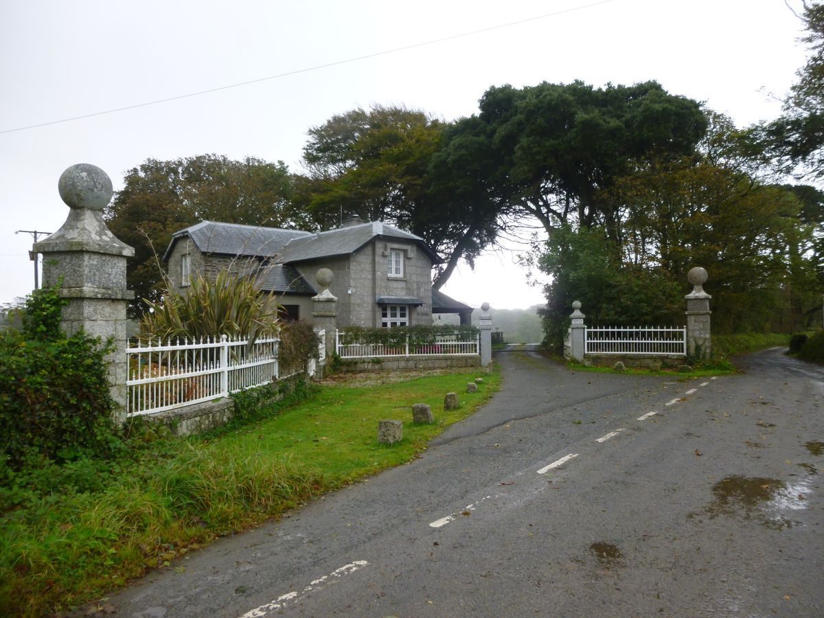
Menabilly is approached from the minor road which forms the western boundary of the site at a point c 400m south of Menabilly chapel. The entrance comprises a pair of square-section granite piers surmounted by ball finials which support an early C19 metal gate. The gate piers are flanked by low granite quadrant walls which support white-painted railings (replaced late C20), which in turn terminate in a further pair of square-section piers. Within the site and to the east of the entrance stands West Lodge (listed grade II), a picturesque two-storey structure built in granite ashlar with a single-storey pentagonal verandah to the south affording views across the park. West Lodge is probably of C18 origin but was rebuilt in its present form in the early C19 for William Rashleigh I.
From West Lodge the tarmac west drive leads c 400m south-east through the park before joining the east drive and sweeping c 240m east-south-east to reach the carriage turn below the south facade of the house. The stables, today (2000) known as Rashleigh Cottage, are situated c 30m south-west of the house adjacent to a service drive which passes c 300m west from the stables along the southern boundary of the park to reach the minor road on the western boundary of the site. This drive is today (2000) a track.
The east drive enters the site from the junction of the A3082 road and the B3269 Passage Lane c 1.5km north-east of the house. The entrance is marked by East Lodge, a picturesque two-storey structure of early C19 origin (altered late C20). Beyond the Lodge the drive, today (2000) a track, passes c 1.4km south-west through Menabilly Wood, a mixed plantation underplanted with specimen rhododendrons. The drive follows a stream which flows south-west through the valley, and passes over a footpath on a C19 stone bridge c 400m south-west of East Lodge. The drive crosses the stream on C19 stone bridges at two points c 1km and 1.6km south-west of East Lodge. Beyond the second bridge the drive passes immediately south of South Cot and sweeps north-north-west for 400m before entering the park and sweeping south-west for c 350m to join the west drive c 190m west-north-west of the house. The east drive appears to have been developed by Philip Rashleigh III or William Rashleigh in the late C18 or early C19; the ornamental planting in Menabilly Wood formed part of the early and late C19 improvements made by William Rashleigh and Jonathan Rashleigh.
A further drive leads south-east and south through the pleasure grounds from Rashleigh Cottage to Polridmouth. This drive is today (2000) a track.
PRINCIPAL BUILDING
Menabilly (listed grade II*) stands on a spur of level ground from which the land drops away to the north-east and east. The house comprises four ranges built around a central courtyard, with a further L-shaped wing extending to the north-east and a balancing L-shaped range of service quarters to the north-west of the main house. The two-storey south or entrance facade is constructed in coursed stone under a hipped roof which is partly concealed behind a moulded cornice and parapet. It is lit by tall sash windows, while a centrally placed door has a pilastered doorcase with a broken pediment. The east or garden facade is of similar design, while the north-east range comprises two storeys above a basement; it also has hipped slate roofs and tall sash windows.
Menabilly was originally built in the late C16 or early C17 for John Rashleigh II. This house was severely damaged during the Civil War, and was rebuilt to its present courtyard plan in 1710-15. Further extensive alterations were made for William Rashleigh in 1821, while the north-east and north-west ranges were built in the mid C19.
GARDENS AND PLEASURE GROUNDS
The informal pleasure grounds and woodland gardens are situated to the north, east, and south of the house and comprise areas of level ground immediately adjacent to the house, and the valley to the north-east, east, and south-east of the house. In addition, Menabilly Wood to the north-east of the house includes ornamental trees and conifers which are underplanted with C19 specimen shrubs.
A lawn bordered to east and west by mixed ornamental trees and shrubs extends c 160m south from the house to a walk or drive which leads south-east to Hooker's Grove. Adjacent to the drive stands a granite cross (listed grade II). To the south-west of the drive is a further area of lawns and ornamental planting. The lawns return below the east and north facades of the house and are similarly bordered by mixed ornamental trees and shrubs.
A series of curvilinear walks lead through the informal pleasure grounds on the north-east- and south-west-facing slopes of the valley to the north-east of the house; these continue south into the valley south-east of the house. Here, further ornamental trees and conifers are underplanted with a collection of C19 rhododendrons and other ornamental shrubs. This area is known as Hooker's Grove, commemorating William Rashleigh's friendship with Sir Joseph Hooker and the supply of plants to Menabilly from Kew in the mid C19. In the valley below Hooker's Grove a stream is dammed to form a chain of three pools, the southern and most extensive being retained by a concrete dam above Polridmouth beach. Some 720m south-east of the house are the ruins of a late C18 grotto (listed grade II). Octagonal on plan, the grotto is constructed from rounded quartz boulders with joints snecked with sea shells; each wall is surmounted by a small gable. The pyramidal roof no longer survives, and the interior was formerly ornamented with a collection of shells and minerals gathered by Philip Rashleigh III in the mid and late C18, together with a circular table composed of polished Cornish granites. The grotto was in poor condition by 1940 (Pett 1998). Constructed for Philip Rashleigh III in the late C18, an early C19 watercolour (in Pett 1998) shows the grotto linked to a wall surmounted by rocks and pierced by a gothic arch flanked by whale bones. To the east of the remains of the grotto stands Polridmouth Cottage, a two-storey stone structure of early C19 origin which overlooks the lower pool and the beach.
In the late C18 Philip Rashleigh III and his advisor, Thomas Gray, removed formal gardens associated with the early C18 house, laying out lawns, shrubberies, and plantations. Sir Colman Rashleigh described traces of formal gardens showing in the lawns during dry weather (c 1845), and commented that Gray was 'all for shaving the lawn and dotting it with clumps and confining it with a belt' (Memoirs, CRO). Philip Rashleigh's pleasure grounds extended through the valley south-east of the house to include the grotto and foreshore at Polridmouth. Philip Rashleigh undertook extensive planting in the pleasure grounds, some plants probably being obtained from William Townsend Aiton (1766(1849) at Kew as well as local nurseries (DD/R 5685/1, CRO). Sir Colman Rashleigh commented (c 1845) that 'Mr Rashleigh has indeed relieved the monotony and tameness [of the grounds] by the groups of shrubs which he has planted and scattered throughout the Pleasure Ground' (Memoirs, CRO). Philip Rashleigh's improvements were continued by William Rashleigh who inherited Menabilly in 1811; he was responsible for sustaining and the developing the plant collections (Pett 1998). Further development of the plant collections took place under Jonathan Rashleigh V and Jonathan Rashleigh VI in the late C19 and early C20; this included the formation of an important collection of bamboos, and the expansion of the early and mid C19 collection of rhododendrons (DD/R 5688, CRO). Late C19 correspondence refers to an avenue of Dracaenas in the pleasure grounds (location unknown), the bamboo collection, and groups of alternate blue and pink hydrangeas planted around the edges of the main lawns (FS/3/1190, CRO).
PARK
The park is situated on a gentle east-facing slope c 80m west of the house, and remains (2000) pasture with scattered specimen trees and conifers. It is crossed from north-west to south-east by the west drive, from which there are views east across the park to Ash Wood c 200m north-east. To the north-west the park adjoins Cocklehorn Plantation, a mixed wood through which a walk passes to emerge into a meadow which it crosses to reach Menabilly Chapel c 880m north-west of the house. The Chapel, which stands in a walled enclosure planted with C19 specimen trees, conifers, and shrubs, was built by William Rashleigh c 1814 (Lysons 1814).
The agricultural land to the north of the park and to the south of the Chapel preserves ornamental clumps of mature pines, while there is further, similar ornamental planting in the agricultural land to the east of the park, and on the west-facing slope above and to the east of Ash Wood (all outside the site here registered).
The park appears to have assumed its present form as part of the improvements undertaken by Thomas Gray for Philip Rashleigh III in the late C18; the planting was developed in the early and mid C19 for William Rashleigh.
KITCHEN GARDEN
The kitchen garden is situated on a south-facing slope c 200m south-west of the house. Approximately rhomboid-shaped on plan, the garden is enclosed by stone walls c 3m high. It is no longer in cultivation (2000) and is in an overgrown condition.
REFERENCES
W Borlase, The Natural History of Cornwall (1758), p 228
D and S Lysons, Magna Britannia (1814), pp 316-17
C S Gilbert, Historical Survey of Cornwall ii, (1820), p 874
J C Loudon, Encyclopaedia of Horticulture (1822), p 1247
F W Stockdale, Excursions in Cornwall (1824), p 41
Lake's Parochial History of Cornwall ii, (1868), p 32
Gardeners' Chronicle, i (1886), pp 817-21; i (1903), pp 234-6
N Pevsner and E Radcliffe, The Buildings of England: Cornwall (2nd edn 1970), pp 116-17
B Jones, Follies & Grottoes (1974), pp 288-9
S Pring, Glorious Gardens of Cornwall (1996), p 20
D E Pett, The Parks and Gardens of Cornwall (1998), pp 155-8
Maps
OS 6" to 1 mile: 1st edition published 1881
Illustrations
G Boney, watercolour view of the grotto, Menabilly, 1805 (reproduced in Pett 1998, p 156)
Aerial photographs, 1959 (HAW 9399/28, 29), (NMR)
Archival items
Memoirs of Sir Colman Rashleigh, mid C19 (FS/3/1127/1), (Cornwall Record Office)
Correspondence from Jonathan Rashleigh V to Kew Gardens, late C19 (FS/3/1190), (Cornwall Record Office)
Rashleigh family collection including planting records, nursery catalogues, and correspondence (DD/R), (Cornwall Record Office)
Description written: December 2000, Amended: March 2001
Register Inspector: JML
Edited: October 2001
- Visitor Access, Directions & Contacts
Telephone
01726 808150Website
https://www.menabilly.comDirections
Menabilly lies on the south coast of Cornwall, east of St. Austell.
- History
The following is from the Register of Parks and Gardens of Special Historic Interest. For the most up-to-date Register entry, please visit the The National Heritage List for England (NHLE):
www.historicengland.org.uk/listing/the-list
HISTORIC DEVELOPMENT
In the early 16th century Philip Rashleigh, a merchant from Barnstaple, Devon, began trading from Fowey. Through his son's marriage with Alice Lanyon the family acquired property in Cornwall, and was able to build a new town house in Fowey. In 1596 Philip Rashleigh's grandson, also John, purchased property at Menabilly, outside Fowey and began to build a new house which was completed by his son Jonathan. During the Civil War the house was looted; it was restored and improved in 1710-1715 by Jonathan Rashleigh II and his son Philip, to whom the estate was given in the early 18th century. Philip Rashleigh II was also responsible for developing the pleasure grounds which benefited from the coastal climate; Borlase noted (1727) that 'every thing that belongs to the flower-garden, and grows in any part of England, will thrive and flourish here'. Philip Rashleigh III, who inherited Menabilly in 1764, continued the development of the grounds, constructing a grotto near the coast at Polridmouth and, in the late 18th century, calling in Thomas Gray to landscape the grounds. Gray's work at Menabilly was criticised by Philip Rashleigh's cousin, Sir Colman Rashleigh of Prideaux, who commented that 'in destroying the formal features of that place entirely divested it of the charm which belonged to it in a more formal condition. It is now nothing more than a house in a tame, flat field, at least as far as Mr Gray's alterations are concerned' (Memoirs, Cornwall Record Office).
Philip Rashleigh died in 1811 when the estate passed to his nephew, William (b 1777), who was already noted for his interest in new and exotic plants. William Rashleigh maintained close connections with the Royal Botanic Gardens, Kew, exchanging plants and seeds and developing a valley garden at Menabilly which was known as Hooker's Grove as a compliment to his friend, Sir Joseph Hooker (1817-1911); by 1822 Loudon identified Menabilly as a 'show-place' in his gazeteer of Cornish gardens (Loudon 1822). When William Rashleigh died in 1855 his son, also William, built a new marine villa, Point Neptune, at Readymoney Cove west of Fowey in preference to residing at Menabilly. At Point Neptune he developed an ornamental carriage drive and built a family mausoleum on St Catherine's Point. William's brother, Jonathan Rashleigh V (1820-1905) inherited in 1871, and together with his son, Jonathan VI (b 1845), made significant additions to the plant collections at Menabilly including many bamboos and eucalyptus. In the 1930s the house was left unoccupied, and in 1940 it was let to the author, Dame Daphne Du Maurier (1907-1989), who drew upon Menabilly for inspiration in her novels 'Rebecca' and 'The King's General'. Today (2000) the site remains in private ownership.
- Features & Designations
Designations
The National Heritage List for England: Register of Parks and Gardens
- Reference: GD1642
- Grade: II
Features
- House (featured building)
- Description: John Rashleigh built a new house which was completed by his son Jonathan. It was restored in 1710-15.
- Earliest Date:
- Plantation
- Drive
- Description: Carriage drives
- Stream
- Pool
- Description: A stream flowing through the valley is dammed to form a chain of pools.
- Landscape garden
- Woodland
- Key Information
Type
Park
Purpose
Recreational/sport
Principal Building
Domestic / Residential
Survival
Extant
Hectares
65
Open to the public
Yes
Civil Parish
Fowey
- References
References
- {English Heritage Register of Parks and Gardens of Special Historic Interest} (Swindon: English heritage 2008) [on CD-ROM] Historic England Register of Parks and Gardens of Special Historic Interest
- Pevsner, N and Radcliffe, E {The Buildings of England: Cornwall} (Harmondsworth: Penguin, 1970) pp 116-117 The Buildings of England: Cornwall
- Pett, D E {The Parks and Gardens of Cornwall} (1998) pp 155-158 The Parks and Gardens of Cornwall