Introduction
Kingston Lacy is a 17th-century house and parkland with woodland, avenues and gardens of around 164 hectares. The estate was radically remodelled in the 19th century by Sir Charles Barry, and includes 19th-century gardens of 11 hectares.
Terrain
The site slopes gently from north-east to south-west, while the land rises to the north-west to a summit at Badbury Rings.The following is from the Register of Parks and Gardens of Special Historic Interest. For the most up-to-date Register entry, please visit The National Heritage List for England (NHLE):
Parkland developed in the 17th, late 18th and 19th centuries, together with late 19th century formal gardens and informal pleasure grounds.
Location, Area, Boundaries, Landform and Setting
Kingston Lacy is situated c 2km north-west of Wimborne Minster, to the south-west of the B3082, Blandford Road. The c 164ha site comprises some 5ha of gardens and pleasure grounds and c 159ha of park and other ornamented land, and is bounded to the north-east and east by Blandford Road from which it is separated by a variety of fences and hedges, and, to the east, by a low stone wall forming a ha-ha allowing easterly views from the park to a clump of cedars to the east of the road. To the south-east the boundary is formed by a minor road, Abbott Street, while to the south-west and west the site is bounded by a track which connects Abbott Street to Blandford Road. The site slopes gently from north-east to south-west, while the land rises to the north-west to a summit at Badbury Rings. There are southerly views across the valley of the River Stour.
Entrances and Approaches
The site is approached from Blandford Road to the north, at a point c 500m east of West or Blandford Lodge. The entrance, comprising a pair of C19 style timber carriage gates, is set back from the road behind wide grass verges and is flanked by hedges which enclose Kingston Plantation from the road. Beyond the entrance a tarmac drive sweeps c 200m south-west through the boundary plantation and park, joining the north-west drive c 550m north-north-west of the house.
The present principal entrance and section of drive connecting it to the north-west drive were constructed by the National Trust c 1982. The north-west entrance is marked by Blandford Lodge, an early C20 single-storey stone structure, and wrought-iron gates supported by stone piers (all listed grade II). The drive sweeps south-east and south from the entrance to arrive at a carriage turn below the north facade of the house.
A further entrance, marked by a similar early C20 lodge and wrought-iron gates (listed grade II), leads from Blandford Road at a point c 1km east of the house. East Lodge is set below and to the north-west of a mixed plantation, Entrance Copse, which marks the eastern extremity of the park. Beyond the entrance, the drive extends first south-west and then north-west through the park to arrive at the carriage turn north of the house. A spur leads south from the east drive at a point c 650m east of the house, to reach Kingston Lacy Home Farm, which is situated c 700m south-east of the house to the south of Abbott Street, outside the site here registered.
A third drive, which today (2004) survives as a track, leads south from the late C19 stables to the north-west of the house, through the park, to an entrance on the track forming the south-west boundary of the site. This entrance is marked by an early C20 two-storey brick lodge.
The system of drives was laid out c 1811 when Henry Bankes the Younger (d 1834) extended the park and secured the diversion of the Blandford Road to a more northerly course (NT 2001). The lodges were constructed by Henrietta Bankes in 1912-13 (ibid).
Principal Building
Kingston Lacy (listed grade I), known until c 1840 as Kingston Hall, stands towards the centre of the site. The house, which is constructed in brick cased in Chilmark stone, comprises two storeys with a basement and an attic storey lit by dormers. The hipped roof is covered with lead, with a central flat section surrounded by a balustrade. A slender cupola rises from the centre of the roof. The entrance, through a mid C19 porte-cochère, is situated to the north, while to the south a centrally placed door surmounted by a segmental pediment leads to a stone-flagged terrace extending the full width of the building. The east facade has a triple-arched loggia which provides access to the garden, while the plainer west facade gives onto the late C18 laundry and kitchen court (listed grade I).
Kingston Lacy was originally constructed to the design of Sir Roger Pratt in 1663-7 for Sir Ralph Bankes (d 1677). The house was built in brick, with a hipped, balustraded roof and cupola. This arrangement was altered in 1736-8 by John Bankes the Younger when the roof had to be reconstructed without the balustrade and cupola. Further internal and external alterations were made by R F Brettingham, nephew of Matthew Brettingham, for Henry Bankes the Younger in the 1780s, including the construction of a new entrance on the east side of the house, and a verandah on the south facade.
The house assumed its present form in 1835-41, when William Bankes commissioned Charles Barry (1795-1860) to undertake an extensive scheme of improvements which included casing the C17 brick house in Chilmark stone, reinstating the C17 roof form and cupola, and removing many of the late C18 additions. Barry returned the entrance to the north side of the building, providing the porte-cochère to shelter the principal door, and constructed the loggia on the east facade and the terrace to the south. Both William Bankes and Barry worked in the style of Inigo Jones, to whom the house was at that time attributed.
The single-storey kitchen and laundry buildings which enclose the north and south sides of the court to the west of the house were constructed in brick to the design of William Rice (d 1789), Custom Surveyor, for Henry Bankes the Elder in 1772-6. The red-brick stables (listed grade II) which stand to the west of the kitchen court were constructed to the design of T H Wyatt in 1880; the original stable court was to the east of the house.
Gardens and Pleasure Grounds
The formal gardens are situated to the south and east of the house, with an area of informal pleasure grounds extending to the south-east.
A stone-flagged balustraded terrace (listed grade I) extends below the south facade of the house, with a series of mid C19 bronze urns by Carlo Marochetti set at regular intervals on the balustrade; the terrace is terminated to east and west by stone benches set in alcoves. A centrally placed flight of stone steps descends from the terrace to a gravel walk which is terminated to the east by a stone bench seat backed by yews, and to the west by a box-edged rose bed with a central armillary sphere. Panels of lawn to the north and south of the gravel terrace walk support a further series of marble urns and a pair of bronze urns, while the piers at the bottom of the steps from the south terrace support a pair of Rosso Veronese lions carved by Giuseppe Petrelli in 1848 after the originals on the Capitol, Rome. The gravel terrace is retained to the south by a low stone wall on which are set further C19 marble urns, while a series of marble well-heads are arranged to contain clipped specimen bays during the summer months.
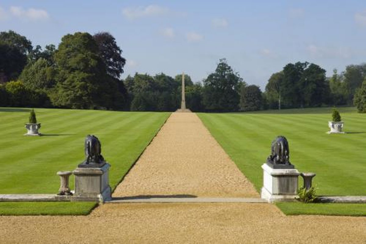
A shallow flight of stone steps flanked by a pair of mid C19 bronze lions by Comperot (all listed grade II) descends to a gravel walk extending south on the axis of the centre of the garden facade of the house. This walk divides two areas of level lawn, that to the west separated from the park by a brick ha-ha and a belt of ilex and Turkey oaks. Each lawn supports a further Veronese well-head (listed grade II), while the gravel walk is terminated to the south by a C2 BC Egyptian obelisk (listed grade II*), originally erected at the Temple of Isis on the island of Philae by Ptolemy VII and Cleopatra III. The obelisk was acquired in Egypt by William Bankes in 1815, and was finally re-erected at Kingston Lacy in 1839, the Duke of Wellington having laid its foundation stone in 1827 (inscription).
The south terraces and lawn assumed their present form in the mid C19 as part of the improvements undertaken by William Bankes; the collection of urns and sculpture is contemporary with this scheme. The mid C19 formal gardens replaced an area of informal lawns laid out in the late C18 by Henry Bankes the Younger and shown in an engraving published by J P Neale (Neale 1818), which in turn replaced the early C18 walled formal gardens and a semicircular exedra containing statues which survived to be recorded on Woodward's plan of 1774-5. The early C18 formal garden probably embodied the structure of Sir Ralph Banke's mid C17 garden, as improved by his son, John Bankes the Elder, in 1713 (NT 2001), and was adjoined to east and west by a pair of formal wildernesses.
To the east of the house, and separated from the south terrace by a low stone kerb ornamented with urns and a north-facing grass bank traversed by a flight of stone steps, is a rectangular formal garden known as the Dutch Garden, comprising a series of geometrical flower beds for seasonal planting set in lawn. The focal point of the garden is a lead putto placed on a stone pedestal, while low domes of clipped golden yew are arranged in a symmetrical pattern. To the north the garden is enclosed by a wall, while to the east a centrally placed flight of stone steps descends to a further area of lawn adjoined to the north by herbaceous borders. The axis of the east facade of the house, the formal garden, and the lower lawn is projected eastwards into the park by a mid C19 avenue of cedars.
The formal garden east of the house was laid out to the design of C E Ponting, Salisbury Diocesan Architect, in 1899, with the topiary yews being added to the original scheme in 1912 (ibid). Plans for a formal garden approached by a double flight of stairs from the south terrace provided by Charles Barry in 1835 do not appear to have been implemented (ibid; Jackson-Stops 1992), while planting schemes for Ponting's formal garden obtained from William Goldring (1854-1919) in 1899-1906 may not have been realised (NT 2001). The formal garden occupies the site of the late C18 entrance court, formed when Henry Bankes the Younger commissioned R F Brettingham to remodel the house. The entrance court replaced an early C18 bowling green (ibid).
An area of informal pleasure grounds is situated to the east of the south lawn. To the north-east, screened from the lawn by a box hedge clipped into a series of domes and by mature yews, the Fernery comprises a series of shaded serpentine walks separating slightly raised rock-edged beds planted with a collection of ferns. To the north-east there is a pool and cast-iron fountain. The garden is enclosed to the east by a brick wall, perhaps of C17 origin. The Fernery was completed in its present form by 1900 (ibid), and occupies the site of a late C17 or early C18 wilderness which is shown on Woodward's plan (1774-5).
A gravel walk leads south-south-east from the eastern end of the south terrace, passing to the west of the Fernery and extending through an avenue of cedars. The trees forming the Cedar Walk were planted by visiting dignatories including the Duke of Wellington (1827), the Kaiser (1907), and HRH the Prince of Wales (1996). The walk is adjoined by lawns, backed to the east by mixed ornamental shrubbery and to the west by the Sunken Garden, an area of geometrical beds laid out to designs supplied by William Goldring in 1899-1904. Four early C20 lead statues representing the Seasons were relocated from the kitchen garden in the late C20 (NT 2001). To the south-east the Cedar Walk is terminated by a stone baluster sundial, from which point walks radiate east to the Lime Walk, south to the Lady Walk, and west to an area of mixed planting known as Blind Wood, which contains a stone obelisk (listed grade II) erected by Walter Ralph Bankes in 1887 to commemorate Queen Victoria's Golden Jubilee.
The Lime Walk extends c 200m east along the north side of a mixed plantation, Chalk Pit Copse, which screens the park from Abbott Street to the south-east. The avenue includes some trees which were planted by Sir Ralph Bankes in the mid C17 (Woodward, 1774-5; NT 2001), and was extended eastwards in the late C19 to allow access to The Nursery, an area of woodland planted in the late C20 with George Hyde's collection of hybrid rhododendrons (NT 2001). From the eastern end of the Lime Walk, and the parallel Laurel Walk, further walks lead south and west through the woodland and shrubbery to join the southern end of the Lady Walk c 50m north of the kitchen garden. The Lady Walk, which leads c 270m north to join the Cedar Walk adjacent to the sundial, was developed as an extensive Japanese Garden in the early C20; this area is currently (2004) under restoration.
To the west of the house, the area between the Kitchen Court and the late C19 stables is laid out as a rose garden with a central circular lawn and bed. This area was developed c 1882, although the present planting scheme dates from the late C20.
Park
The gently undulating park surrounds the house to the north, east, south-west, and west and is enclosed to the north, south, and west by boundary plantations. Walks lead west from the Lady Walk c 450m south of the house through the south and west boundary plantations to join a similar walk leading though Kingston Plantation to the north, thus forming an extended circuit walk or ride (OS 1902). The park remains pasture, with many scattered specimen trees which are loosely grouped to frame a series of vistas across the park from the house and pleasure grounds. Some 320m south-west of the house an C18 stone obelisk (listed grade II) stands on an eminence, while to the west of the south lawn a short lime avenue extends into the park. This survives from Sir Ralph Bankes¿ mid C17 formal park landscape which is recorded on Woodward's plan (1774-5). Two pools situated in the park c 260m north-east of the house appear to correspond to features shown on Woodward's late C18 plan.
The park assumed its present form following the Enclosure Act of 1784 which allowed Henry Bankes the Younger to extend the C17 park, in part by removing the hamlet of Kingston which was situated adjacent to the C16 Keeper's Lodge (listed grade II), diverting the Blandford road, and converting former agricultural land to parkland. Further land to the east of the house was imparked by 1811, and an extensive planting programme was undertaken from 1789 (NT 2001).
The much smaller early C18 park, originally laid out by Sir Ralph Bankes in the mid C17 to accompany his new mansion, comprised avenues radiating in two patte d'oie to the north and south of the house. The avenues to the south of the house appear to have been planted by Sir Ralph, and this area of park was overlooked by a summerhouse or banqueting house on the edge of the formal gardens, which was demolished in 1721 (ibid). The northern avenues were formed by Henry Bankes the Elder in 1733-5 by cutting through a plantation of elms which had been made in 1716-17. These features are recorded by Woodward on his plan of 1774-5.
The medieval deer park appears to have been situated to the north and north-west of the present mansion, perhaps separated from the medieval manor house by the original course of the Blandford road. Lodge Farm (listed grade II*) situated opposite the north-west entrance to the present park (outside the area here registered), incorporates the remains of the medieval park keeper's lodge. Badbury Warren to the north-west of Lodge Farm was enclosed as farmland in 1740 (ibid).
During the Second World War an extensive military encampment was established in the south-east quarter of the park. This was subsequently removed and the park restored in the late C20.
Kitchen Garden
The kitchen garden is situated to the south of the pleasure grounds, from which it is separated by Abbott Street. The garden is connected to the house, c 530m north, by the Lady Walk. The garden is approximately rectangular on plan and is enclosed by red-brick walls c 3m high. A slip garden to the north is separated from Abbott Street by a hedge, while the garden is entered through ornamental wrought-iron gates situated at the north-west and north-east corners. The garden, which is today (2004) in use as a commercial nursery, retains some early C20 glasshouses and associated structures. The gardener's house stands outside and to the north-east of the garden.
The kitchen garden and the gardener's house were constructed in the early C20 for Henrietta Bankes. An earlier kitchen garden is shown on Woodward's late C18 plan to the south of the eastern wilderness.
Other Land
The beech avenue lining Blandford Road for c 3.5km north-west of Blandford Lodge is included in the site here registered. It was planted by William Bankes in 1835. To the north of the beech avenue, Badbury Rings, an Iron Age hillfort (scheduled ancient monument) is planted as an eyecatcher from the park. It was first planted with pine trees to delineate the views towards local landmarks in 1761; this planting was restored by the National Trust in the late C20.
To the south-east of the park an oak avenue planted in 1842 (NT 2001) extends from the church of St Stephen (outside the site here registered), across Pamphill Green to the school and almshouse. The church was built for Henrietta Bankes in 1907 to the design of C E Ponting.
REFERENCES
J P Neale, Views of the seats - I, (1818)
J Hutchins, The History and Antiquities of the County of Dorset III, (2nd edn 1868), p 236
Country Life, 7 (21 April 1900), pp 496-501; 179 (17 April 1986), pp 1016-1019
C Holme, Gardens of England in Southern and Western Counties (1907), pl 87
A Oswald, Country Houses of Dorset (2nd edn 1959), pp 144-147
N Pevsner and J Newman, The Buildings of England: Dorset (1972), pp 244-246
G Jackson-Stops, An English Arcadia 1600-1990 (1992), pp 134-137
Kingston Lacy, guidebook, (National Trust 1994)
Kingston Lacy Garden and Park, guidebook, (National Trust 2001)
Maps
- Kingston Manor, 1742 (DI/BKL), (Dorset Record Office)
- W Woodward, Plan of the manor of Kingston, 1774-5 (DI/BKL), (Dorset Record Office)
- A Plan of the Allotments within the parish of Wimborne Minster in the County of Dorset, 1786 (Incl 1.I.1), (Dorset Record Office)
- OS 6" to 1 mile: 1st edition surveyed 1885, published 1890
- 2nd edition published 1902
- OS 25" to 1 mile: 2nd edition revised 1900, published 1901
Archival items
- The Bankes family archive, including estate accounts, plans, and personal papers, is held at the Dorset Record Office (DI/BKL).
Description written: January 2004
Amended: April 2004
Edited: January 2005
- Visitor Access, Directions & Contacts
Telephone
01202 883402Access contact details
The park and gardens are open throughout the year, but the house is only open between March and October. Please see: http://www.nationaltrust.org.uk/place-pages/191/pages/opening-times-calendar
Directions
The estate lies 1.5 miles west of Wimborne Minster, on the B3082.
Owners
The National Trust
Heelis, Kemble Drive, Swindon, SN2 2NA
- History
The following is from the Register of Parks and Gardens of Special Historic Interest. For the most up-to-date Register entry, please visit the The National Heritage List for England (NHLE):
www.historicengland.org.uk/listing/the-list
HISTORIC DEVELOPMENT
During the medieval period, Kingston Lacy formed part of an extensive royal estate within the manor of Wimborne. The manor house stood to the north of the present mansion, with a deer park to the north-west. The estate was frequently let to supporters of the Crown, including the de Lacy family, earls of Lincoln, while in the mid 15th century it was occupied by John Beaufort, Duke of Somerset (d 1444). His daughter, Lady Margaret Beaufort, mother of Henry VII, was brought up at Kingston Lacy. By the early 16th century, the medieval manor house had fallen into disrepair and much of the open hunting land on the estate was enclosed. In 1603 James I gave the manor to Sir Charles Blount, whose son sold the Kingston Lacy estate to Sir John Bankes in 1636. Bankes, who was appointed Attorney General to Charles I in 1634, was a successful lawyer who originated in Cumberland and had acquired the royal castle of Corfe in the Isle of Purbeck in 1635, which became his principal seat. Sir John died at the fugitive royal court at Oxford in 1644, while his wife, known as 'Brave Dame Mary', defended Corfe Castle through two Parliamentary sieges. When the Castle fell through treachery in 1646 it was slighted and rendered uninhabitable.
In 1663, Sir John's second son, Ralph (knighted 1660), who had inherited the estate in 1656, commissioned Sir Roger Pratt (d 1685) to design a new house to be erected at Kingston Lacy. This building, known as Kingston Hall, was completed by 1667. The new house was provided with formal gardens, some of which were enclosed by walls, while a series of formal avenues radiated through the park. This layout survived to be recorded on a plan by William Woodward in 1774-1775.
Sir Ralph Bankes died in 1677, leaving the estate to his son John, who was a minor. Between 1686 and 1688, Kingston was let to the Duke of Ormonde, the family only returning to the house in 1693. John Bankes and his wife Margaret, daughter of Sir Henry Parker of Honington Hall, Warwickshire, sought to consolidate the family's finances, and made improvements to the house and gardens, possibly realising incomplete elements of Sir Ralph's original scheme (National Trust 1994). John Bankes died in 1714, and the estate remained in his widow's management until 1719 when it passed to his son, John Bankes the Younger. This John Bankes, who remained unmarried, undertook major structural repairs to the house, which included reconstructing the roof in 1736-1738. At his death in 1772, the estate passed to his brother Henry, who despite a tenure of only four years, initiated significant changes, including the enclosure of agricultural land outside the 17th century park, the remodelling of the house, and the construction of new service blocks. In 1776 Henry Bankes was succeeded by his son, also Henry, who continued his father's programme of improvements, implementing the enclosure and expanding the park. Further major changes were made to both the house and its setting by Henry Bankes' son William, who inherited in 1834. A connoisseur who travelled widely in Europe and Egypt buying works of art and antiquities, William Bankes commissioned Charles Barry in 1835 to remodel Kingston Hall, which was now to be known as Kingston Lacy. The programme of improvements was completed in about 1841 and included schemes, some of which remained unimplemented, for new formal gardens. In September 1841, Bankes left England for voluntary exile on the continent after he was accused of `indecently exposing himself with a soldier of the Foot Guards in Green Park [London]'. Work on the house and gardens continued in Bankes' absence under the supervision of his sister Anne, Lady Falmouth (d 1864), while the estate was managed by his brother George, who inherited at William Bankes' death in 1855. George Bankes survived only a year and was succeeded in quick succession by his son and elder grandson. In 1869 Kingston Lacy was inherited by George Bankes' younger grandson, Walter Ralph. Marrying late in life, at his death in 1902 W R Bankes left a two-year-old son, Ralph, and until 1923 the estate was controlled by his widow, Henrietta (d 1949), who was responsible for many improvements including the construction of the church (1907), new entrance lodges (1912-1913), and numerous estate cottages.
In 1923 control passed to Ralph Bankes, who at his death in 1982 bequeathed the Corfe and Kingston Lacy estates to the National Trust. The site remains (2004) the property of the National Trust.
- Associated People
- Features & Designations
Designations
The National Heritage List for England: Register of Parks and Gardens
- Reference: GD1709
- Grade: II
Features
- Tree Avenue
- House (featured building)
- Description: The house has been re-modelled a number of times since it was built in 1667.
- Earliest Date:
- Latest Date:
- Ha-ha
- Description: A low stone wall forming a ha-ha allowing easterly views from the park to a clump of cedars to the east of the road.
- Gate Lodge
- Earliest Date:
- Latest Date:
- Parkland
- Avenue
- Gardens
- Woodland
- Key Information
Type
Estate
Purpose
Ornamental
Principal Building
Domestic / Residential
Survival
Extant
Hectares
164
Open to the public
Yes
Civil Parish
Pamphill
- References
References
- Newman, J and Pevsner, N {The Buildings of England: Dorset} (Harmondsworth: Penguin, 1972) pp 244-246 The Buildings of England: Dorset
- Oswald, A {Country Houses of Dorset} (2nd edn 1959) pp 144-147 Country Houses of Dorset
- {English Heritage Register of Parks and Gardens of Special Historic Interest} (Swindon: English Heritage 2008) [on CD-ROM] Historic England Register of Parks and Gardens of Special Historic Interest
- Black, KM {National Trust Gardens Survey (Kingston Lacy)} (1982) National Trust Gardens Survey (Kingston Lacy)
- Bohea, Freya; Rutherford, Sarah {Kingston Lacy Conservation Plan Kitchen Garden} (2014) Kingston Lacy Conservation Plan Kitchen Garden
- Rutherford, Sarah {Kingston Lacy Park and Garden Conservation Statement} (2014) Kingston Lacy Park and Garden Conservation Statement