Introduction
Charborough Park has about 4 hectares of formal gardens within an 18th century deer park. The park was landscaped in the early-19th century and enlarged in the mid-19th century, and occupies about 364 hectares.The site is occasionally open to the public. Please visit their website (on this site under 'Description').
Terrain
The site is undulating, rising to the south-east from the River Winterborne which flows through the site from south-west to north-east.The following is from the Register of Parks and Gardens of Special Historic Interest. For the most up-to-date Register entry, please visit The National Heritage List for England (NHLE):
Early 19th century park, gardens, and pleasure grounds developed from an 18th century deer park and mid 17th century formal gardens, elements of which survive in the present scheme.
Location, Area, Boundaries, Landform and Setting
Charborough Park is situated c 5km west-south-west of Wimborne Minster, and c 1.5km south-west of Sturminster Marshall. The c 368ha site comprises some 4ha of gardens and pleasure grounds, and c 364ha of parkland and ornamental plantations. The site is bounded to the north and north-west by the A31 road leading from Wimborne Minster to Dorchester, from which it is separated by a mid C19 red-brick wall. To the east and west the site adjoins agricultural land, while to the south it is bordered by a minor road leading south-east from the A31 road to Lychett Matravers, from which it is separated by a further C19 brick wall. To the south-east the site adjoins High Wood, a mixed plantation on rising ground which forms an integral part of the setting of the site. The site is undulating, rising to the south-east from the River Winterborne which flows through the site from south-west to north-east parallel to the north-west boundary, towards the house and the folly tower on the south-east boundary adjacent to High Wood. There are extensive views to the north-west across the valley of the River Stour and west across the Winterborne valley from high ground within the park. The tower is also a significant landmark visible from many points in the surrounding country.
Entrances and Approaches
Charborough Park is approached from the A31 to the north-east and north-west, and also from the minor road leading to Lychett Matravers to the south.
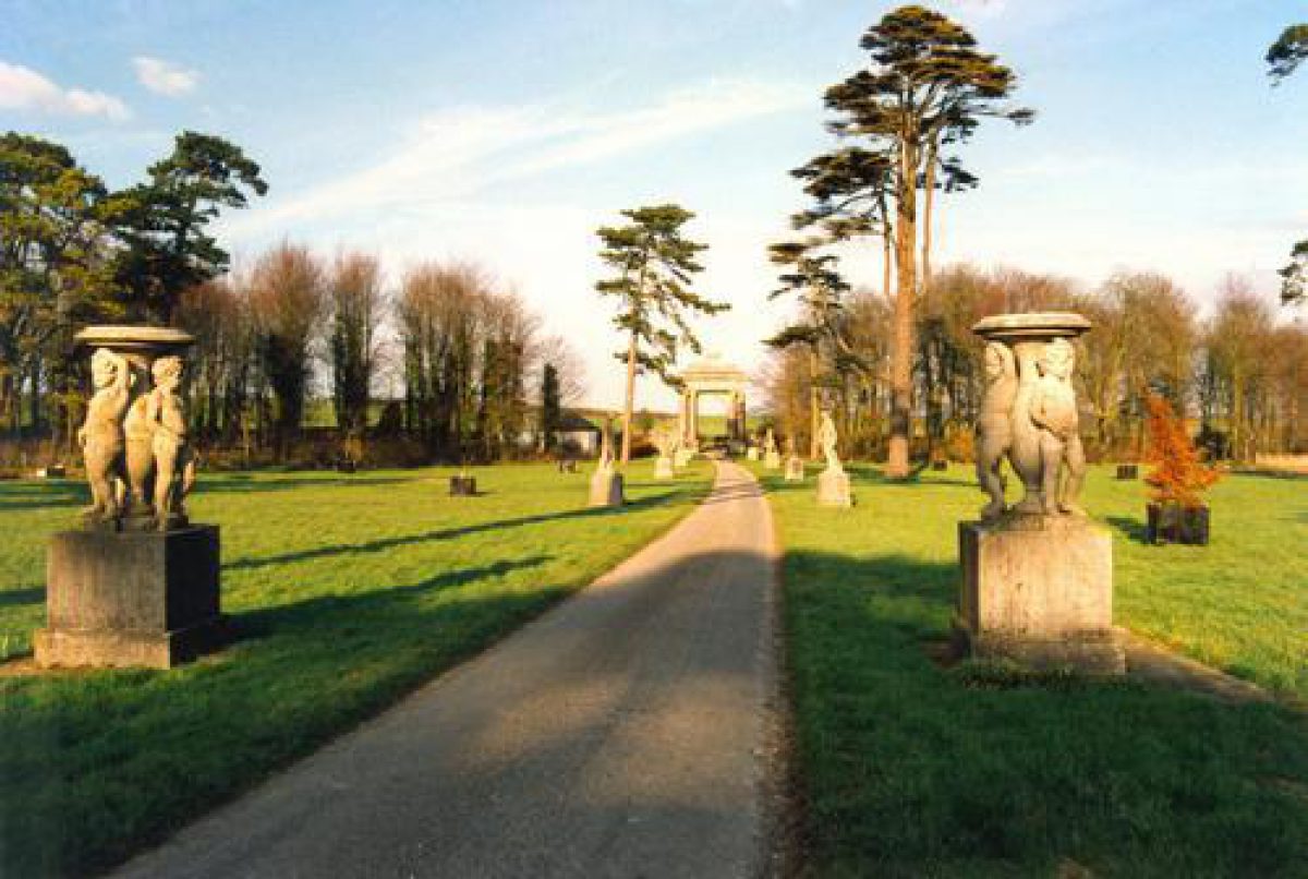
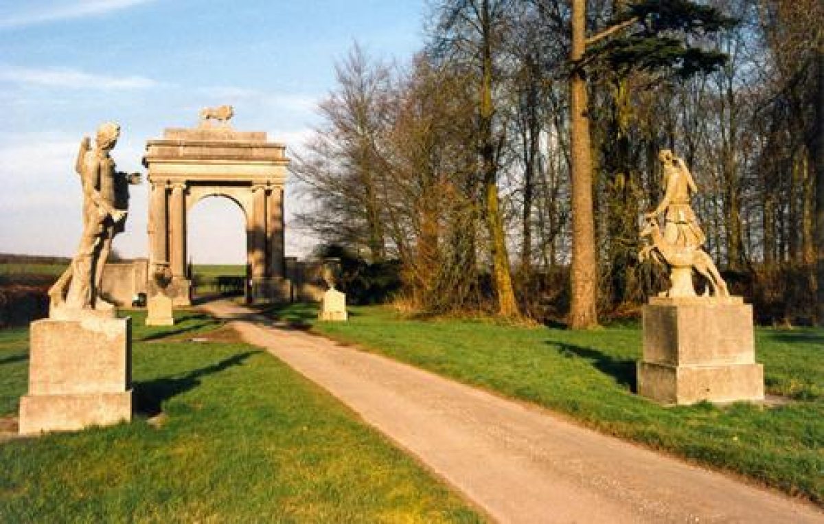
The north-east entrance is situated on the A31 road at a point c 1.5km north-west of the junction of the A31 road and the A350 road, and is marked by Lion Lodge (listed grade II). Lion Lodge comprises an early or mid C19 stucco triumphal arch surmounted by a carved stone lion, the arched opening of which is closed by monumental cast-iron gates obtained from the Great Exhibition (1851). The arch is set back from the road and is flanked by stone quadrant walls. A single-storey lodge-keeper's house stands c 20m west of the entrance. The entrance leads to a tarmac drive which extends c 200m south-west through the remnants of a mid C19 avenue of cedars and pines, beneath which stands a group of C19 composite stone statues and urns.
The drive continues for c 500m south-west through the park, before passing through mid C19 metal gates set in the mid C19 metal deer fence, to enter the deer park. This fence, which follows the line of the parish boundary between Charborough and Sturminster Marshall, corresponds to the north-east boundary of the C18 park prior to its extension by John Sawbridge Erle-Drax in the early C19. Within the deer park the drive continues south-west for c 400m, before sweeping south for c 300m to join the north-west and south drives at a point c 100m north of the house.
The north-west drive enters the site from the A31 road at a point c 650m north-east of the hamlet of Almer. The entrance is marked by East Almer Lodge (listed grade II), an early or mid C19 stucco structure comprising a pedimented archway flanked by quadrant wings. Above the arched entrance, which is closed by C19 wrought-iron gates, an inscription records the diversion of the Wimborne to Dorchester road by John Sawbridge Erle-Drax in 1811-12. A single-storey lodge-keeper's cottage stands behind the western quadrant wing. Beyond the entrance a tarmac drive extends c 750m south through Wire Drove, a mixed plantation. The drive is bordered by grass verges and low clipped laurel hedges, and is joined c 650m south of the entrance by a service drive which leads north-west to the mid C18 Home Farm and Kennels (listed grade II; outside the registered area), and thence to West Almer Lodge.
The north-west drive enters the deer park through Peacock Lodge (listed grade II*), an early C19 stone structure comprising an elliptical arched entrance surmounted by a figure of a stag, flanked by single-storey quadrant wings lit by circular windows. Peacock Lodge marks the western extent of the C18 park but does not appear to correspond to the lodge shown at this point on a late C18 estate plan. Beyond Peacock Lodge the drive continues for c 770m through the park, ascending gently to the junction with the north-east and south drives north of the house. The drive east of Peacock Lodge corresponds to that shown on the late C18 estate plan; the avenue shown on the plan does not survive, and was not recorded on the late C19 OS map (1885).
The south drive enters the site from the minor road leading to Lychett Matravers at a point c 700m east of its junction with the B3075 road. The entrance is marked by Boar Hill Lodge, a single-storey C19 structure which stands adjacent to C19 metal gates supported by piers flanked by quadrant walls, all in white brick. The drive leads c 670m north-east through the park before passing along the east side of Eagle Plantation for c 400m and joining the north-west and north-east drives north of the house. The south drive corresponds to a track shown on the late C18 estate plan, the southern extent of the C18 park approximating to the southern end of Eagle Plantation.
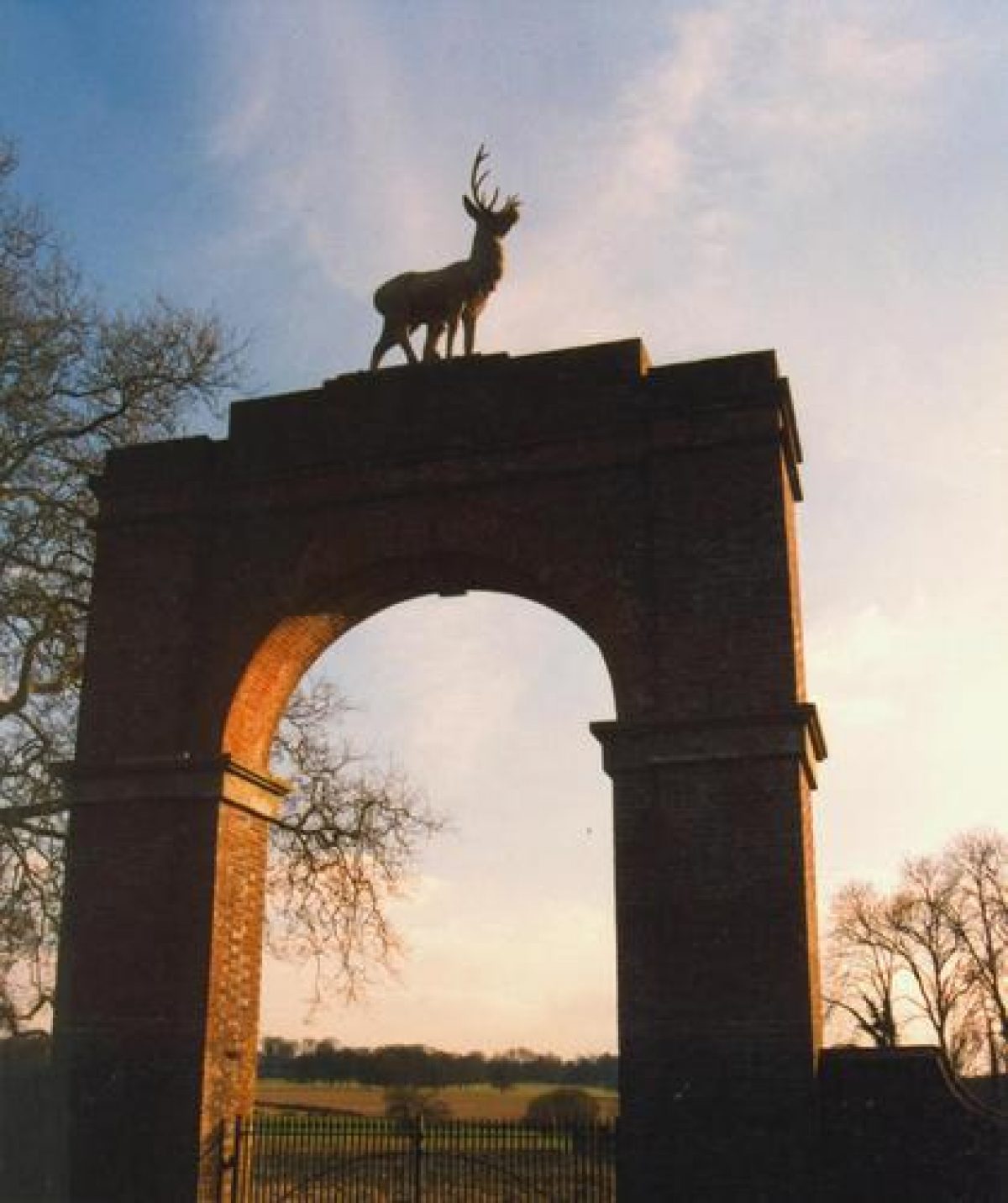
Two further entrances to the site are now (2004) no longer in use. To the north, Stag Gate (listed grade II) stands on the A31 road at a point opposite its junction with a minor road leading to Sturminster Marshall. The early or mid C19 entrance comprises a monumental Roman arch of brick construction surmounted by a lead figure of a stag. The entrance is closed by C19 spiked metal gates; there is no drive beyond the entrance, and none is indicated on the late C19 OS map (1885). Stag Gate corresponds to the point where the Wimborne to Dorchester road was diverted in order to extend the park in 1811-12.
To the south-west of the site a further disused entrance is situated on the minor road leading to Lychett Matravers at a point opposite its junction with the B3075 road. This entrance is marked by Round House Lodge (listed grade II), an early C19 circular, single-storey thatched cottage orné (with a later extension to the east) which stands between two entrances, each comprising a pair of C19 metal gates supported by octagonal brick piers. This entrance now (2004) leads to a woodland ride passing round the western boundary of the park. Round House Lodge corresponds to the southern end of the road which was stopped-up by John Sawbridge Erle-Drax in 1811-12, but does not appear to have served a drive leading to the house (OS 1885).
From the point c 100m north of the house where the drives converge, the principal drive sweeps south and south-west to reach a gravelled carriage turn beneath the west facade of the house. The entrance to the house was moved to its present position c 1810 from the north facade. Two mid C18 oil paintings of Charborough show an enclosed forecourt to the north of the house with a central circular lawn. A similar arrangement is shown on a vignette illustrating the late C18 estate plan. A service drive sweeps south-west round the northern and western boundary of the pleasure grounds to reach the late C18 or early C19 stables and coach house (listed grade II) which stand on high ground c 130m west of the house. These buildings replaced C17 or C18 stables which stood immediately north-east of the house, and which are shown in the mid C18 paintings of the house; these had been removed when the late C18 estate plan was made.
Principal Building
Charborough Park (listed grade I) stands on high ground towards the centre of the site. The house comprises two storeys and an attic, and is constructed in a mixture of stone and stuccoed brick under hipped slate roofs which are concealed behind parapets. The north facade facing the park extends to eleven bays beneath a pediment containing a carved coat of arms which is supported by Ionic pilasters. The facade was extended and the pediment added c 1810 as part of a scheme of improvements attributed to John Nash. The entrance to the mid C17 house was situated on the north side of the building, the original facade corresponding to the seven western bays of the present structure.
The present entrance facade is to the west, where a single-storey portico is supported by Ionic columns. The west facade is terminated to the south by a three-storey tower, beyond which extends the single-storey library wing, perhaps originally an orangery, enclosing the west side of formal gardens to the south of the house. The south and east facades of the house are of relatively plain style, with a further single-storey picture gallery extending east from the south-east corner of the main block. The interior of the house retains the important early C18 staircase decorated by Sir James Thornhill in 1718 for General Erle.
The house as originally built in the mid C17 by Sir Walter Erle was constructed in brick under a hipped roof lit by attic dormers. The entrance was placed to the north, while the west facade overlooked formal gardens. The appearance of this building is recorded in two mid C18 paintings (private collection; CL 1935). A new wing was constructed to the east of the C17 house by Henry Drax c 1740 in order to accommodate Frederick, Prince of Wales. This structure was incorporated into the unified north facade c 1810. The library wing is shown on the late C18 estate plan, but was probably remodelled by Nash and again in the mid C19 for John Sawbridge Erle-Drax. The picture gallery similarly appears to be C18 in origin, with extensive C19 remodelling.
Gardens and Pleasure Grounds
Formal gardens lie to the south of the house, while areas of informal pleasure grounds extend to the west and south-west.
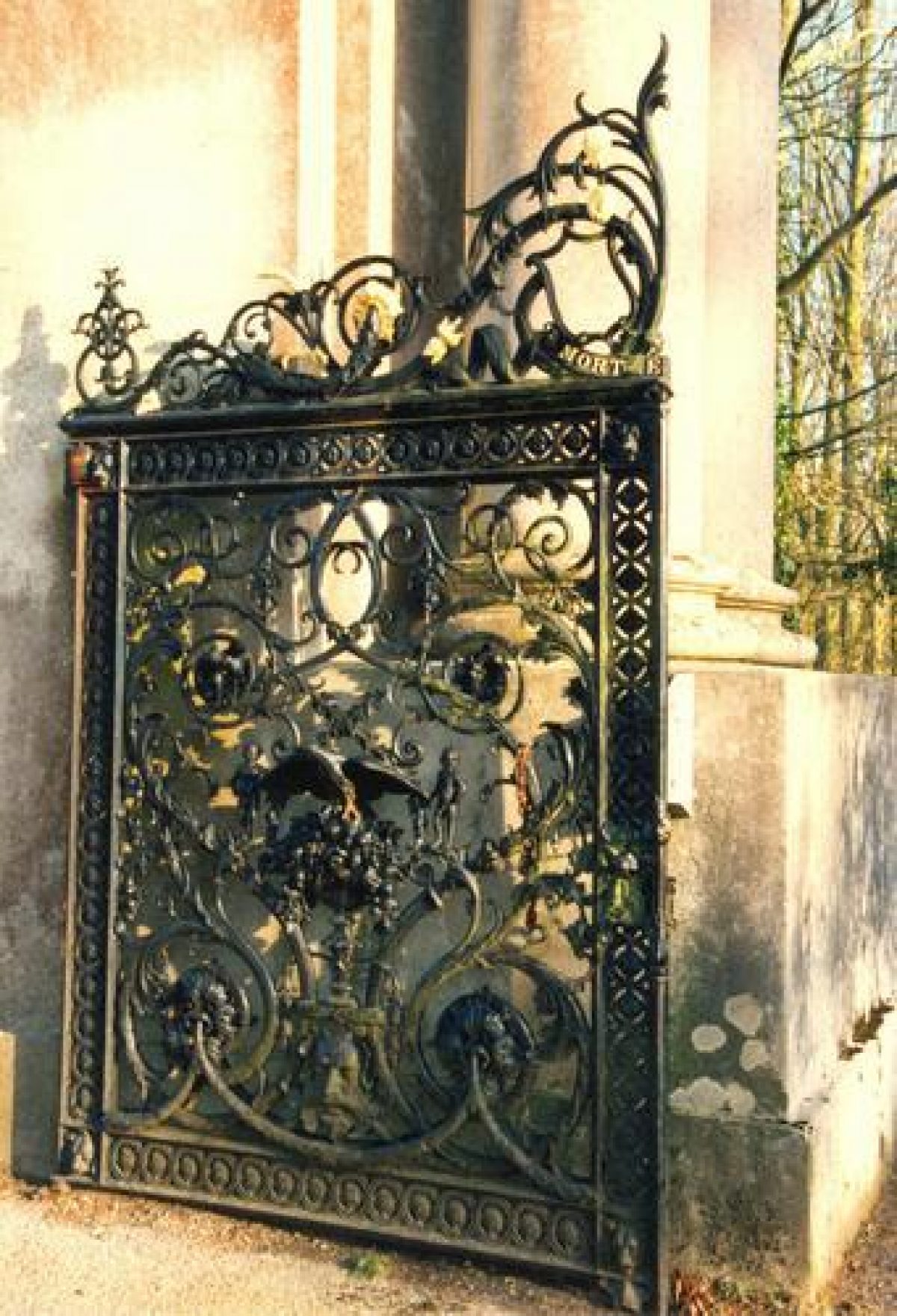
A stone-flagged terrace extends below the south facade of the house, returning along the east facade of the library wing and enclosing an approximately square area of level lawn. The lawn is retained above, and separated from the park to the east, by a stone ha-ha, while a flight of stone steps flanked by stuccoed piers surmounted by urns and supporting simple iron gates (all listed grade II) terminate the flagged terrace to the east, framing a vista of the folly tower in the park. The lawn surrounds a central circular stone-kerbed fountain basin. The formal terraced garden appears to have been laid out in the early C19, probably as part of Nash¿s scheme. It remains substantially as delineated on the late C19 OS map (1885).
To the south-west of the formal garden the ground rises gently towards the kitchen garden. This north-east-facing slope is laid out with lawns beneath scattered specimen trees and groups of ornamental shrubs. A circular stone-kerbed bed, formerly a fountain pool, lies c 80m south of the house.
An area of level lawn planted with scattered specimen trees extends to the west of the house. This lawn is enclosed to the south and west by grass banks which ascend to further areas of informal shrubbery and specimen trees. A grotto (listed grade II) is set into the southern bank, c 50m west of the house. The entrance to the structure is ornamented with a pilastered facade surmounted by a curved Flemish gable. An inscribed tablet set in to the facade commemorates the Glorious Revolution of 1688 and the accession of William III.
The arched opening now leads to an C18 icehouse which apparently replaced an earlier grotto in which General Erle held discussions leading to the Revolution. The lawns to the west of the house correspond to the site of late C17 or early C18 formal gardens shown in the mid C18 views of the house (CL 1935). These gardens comprised two areas, with a parterre to the north and geometrical lawns to the south overlooked by the grotto and a raised terrace ornamented with a series of urns (Mowl 2003). The formal gardens appear to have been removed by the late C18 as they are not recorded on the late C18 estate plan.
A walk ascending from the carriage turn to the south of the west lawn corresponds to the formal terrace. This walk sweeps south-west through the pleasure grounds to reach the north-west end of a further terraced walk which extends c 130m south-east. The outer edge of the terrace is enclosed by a low stone balustrade with pierced quatrefoil-shaped openings, while a centrally placed flight of stone steps flanked by similar balustrades (all listed grade II) descends to the parish church of St Mary (listed grade II*) which stands c 50m south-west of the house. The church is constructed in early Gothic Revival style with corner pinnacles and a gabled facade to the east. It was constructed in 1775 to replace a medieval structure, and was subsequently altered in the early C19. The terrace to the south-west of the church was constructed in the early C19 to form a formal approach to the church.
Above the terrace, further walks ascend through the pleasure grounds to reach a curvilinear conservatory (listed grade II) which overlooks a small fountain basin c 100m south-west of the house. This early or mid C19 building comprises a series of ashlar piers supporting a moulded cornice and C20 glass roof.
A further area of detached pleasure ground is situated to the north-west of the park, adjacent to the north-west drive beyond Peacock Lodge, taking in both banks of the River Winterborne. This area is planted with mixed woodland, through which a series of serpentine paths pass, crossing the river on footbridges, one of which is constructed in the style of a suspension bridge. This area lay outside the park and designed landscape in the C18 and forms part of the area taken in by John Sawbridge Erle-Drax after the diversion of the road in 1811-12. It had assumed its present form by the late C19 (OS 1885).
Park
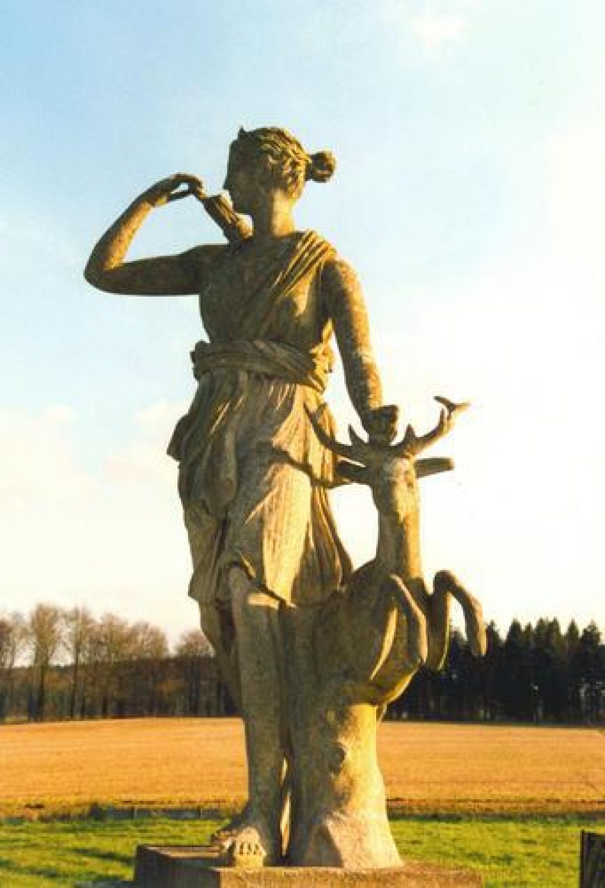
The park surrounds the house and pleasure grounds on all sides and remains (2004) principally pasture, in part grazed by a deer herd. The park is undulating and is characterised by scattered clumps of mature beech trees which frame a series of vistas through the park to the wider landscape beyond. The northern boundary of the park, adjacent to the A31 road, is screened by narrow plantations, while further plantations enclose the park to the east, west, and south-west. To the south-east, the park is wooded and adjoins High Wood (outside the registered area). Some 450m north-east of the house, and visible from it, the Deer Monument (listed grade II) comprises a statue of a stag (possibly Coade stone) set on a brick plinth and flanked by six cannons.
The monument is framed by ornamental clumps and is also visible in views from the north-east drive, whereas the house is concealed by the bluff on which the monument stands. The Deer Monument occupies the site of the Statue of Apollo which is marked on the late C18 estate plan. Some 430m south-east of the house, the Charborough Tower (listed grade II*) stands on rising ground against the background of High Wood. The tower is placed on the axis of the south terrace and is approached by a terraced walk articulated by stuccoed piers beneath moulded caps and broken by two flights of stone steps with pierced traceried balustrades (all listed grade II). The tower is octagonal on plan and comprises five graduated stages constructed in Gothic style.
Originally constructed in 1790, the tower was partially reconstructed and heightened in 1839 following damage by lightening. It appears to occupy the site of an earlier structure which is shown on the late C18 estate plan, while an avenue is shown leading to a structure in this position on the mid C18 views of the house (CL 1935). Several seats marked within the park on the late C18 estate plan do not survive, nor do the kennels shown at the south-west end of Old Nursery Plantation.
The park was developed during the second half of the C18, and was extended to its present area in the early C19 following the diversion of the Wimborne to Dorchester road in 1811-12. The mid C18 views of the house (CL 1935) show the gardens adjoined by agricultural land, while the late C18 estate plan shows a small park, the boundaries of which correspond to High Wood to the south-east, the parish boundary with Sturminster Marshall to the north, and the eastern boundaries of Furze Hill and Forty Acre Bottom to the west. The south-west corner of the C18 park corresponds approximately to the barrow c 800m west-south-west of the house, which was planted as an ornamental feature. John Sawbridge Erle-Drax was able to extend the park to the north, west, and south c 1811-12 by the diversion of the existing Wimborne to Dorchester road, the enclosure of Sturminster Marshall Common Field, and the acquisition of land belonging to William Trenchard.
Kitchen Garden
The kitchen garden is situated on a south-east-facing slope c 160m south-west of the house above the pleasure grounds and church. The garden is rectangular on plan and is enclosed by brick walls c 3m high. The internal space, which is no longer in cultivation, is divided into two equal compartments by a lateral wall. A range of glasshouses remains against the inner face of the north-west wall, which doubles as the east wall of cottages in the stable yard. The late C18 estate plan shows the kitchen garden in its present location, but with an unequal internal division, the smaller, western section having a central pool, and the larger, eastern division having a free-standing range of glasshouses at its north-west corner.
REFERENCES used by English Heritage
Country Life, 77 (30 March 1935), pp 322-327
A Oswald, Country Houses of Dorset (2nd edn 1959), pp 142-144
J Newman and N Pevsner, The Buildings of England: Dorset (1972), pp 139-141
T Mowl, Historic Gardens of Dorset (2003), pp 44-46
Maps
- J Taylor, The Parish & Manor of Charborough belonging to T E Drax Esq Including the Park & Farm in the County of Dorset, c 1780 (Ph 2/2, (Dorset Record Office)
- OS 6" to 1 mile: 1st edition surveyed 1885, published 1892
- OS 25" to 1 mile: 2nd edition revised 1900, published 1901
Illustrations
- Two oil paintings of Charborough Park from the west, c 1740 (private collection) [one reproduced in CL 1935]
- Vignette of Charborough Park from the north, c 1780 (Ph 2/2), (Dorset Record Office)
Description written: June 2004
Amended: December 2004
Edited: April 2005
- Visitor Access, Directions & Contacts
Telephone
01258 857204Website
http://www.charborough.co.ukAccess contact details
Access is limited, please check their website before visiting for details.
- History
The following is from the Register of Parks and Gardens of Special Historic Interest. For the most up-to-date Register entry, please visit the The National Heritage List for England (NHLE):
www.historicengland.org.uk/listing/the-list
HISTORIC DEVELOPMENT
In 1086 Charborough was a royal manor, and during the medieval period it passed by marriage and descent through several families, finally coming into the possession of the Wykes family of Bindon, Devon. In the mid 16th century the Wykes' heiress, Mary, married Walter Erle of Culhampton, Devon. Erle's grandson, also Walter (knighted 1626), fought for Parliament during the Civil War, leading the unsuccessful first siege of Corfe Castle. Royalist troops destroyed Erle's house at Charborough, and after the conclusion of hostilities he built a new house, which remains the core of the present structure, making use of stone and timbers obtained from the slighted Corfe Castle. Erle died in 1665 and was succeeded by his grandson, Thomas, who played a significant role in the Glorious Revolution of 1688, the planning of which is said to have taken place at Charborough. Thomas Erle had a long military career, rising to the rank of General under Queen Anne; he finally retired from active service in 1709 and returned to Charborough where he made alterations to the house, including constructing a new staircase hall with mural paintings by Sir James Thornhill. The formal gardens to the west of the house, which incorporated a grotto in which the accession of William III was apparently discussed, were laid out by General Erle in the 1680s; these gardens survived to be recorded in two paintings commissioned by Henry Drax in the 1740s.
General Erle was succeeded by his daughter, who married Sir Edward Ernle of Maddington, and they were in turn succeeded in 1728 by their daughter, who married Henry Drax of Ellerton Abbey, Yorkshire. Drax was a close associate of Frederick, Prince of Wales, serving as his Secretary and Keeper of the Privy Seal. The Prince visited Charborough in 1741, and was accommodated in a wing specially constructed for the occasion (Country Life 1935).
Drax's son, Thomas Erle Drax, continued to make improvements to the house and estate, rebuilding the parish church adjacent to the house in 1775, while his brother, Edward Erle Drax, who succeeded in 1790, built the folly tower to the east of the house. Edward Drax died in 1791, and Charborough was inherited by his daughter, the wife of Richard Grosvenor, who assumed the surname Erle-Drax. Richard Erle-Drax was responsible for remodelling the house in about 1810, probably employing John Nash (1752-1835) as his architect. It is likely that the 18th century formal gardens west of the house were removed at about this time, and new gardens laid out to the south. At Richard Erle-Drax's death Charborough was again inherited by a daughter, who was married to John Sawbridge; he also took the surname Erle-Drax. John Sawbridge Erle-Drax diverted the road leading from Wimborne to Dorchester in 1811-1812, and extended the park, constructing a park wall and a series of new lodges.
After his death the estate passed to his daughter, the widow of Colonel Francis Plunkett, and then to his granddaughter, Lady Dunsany. When Lady Dunsany died in 1916, Charborough was inherited by her younger son, Admiral Sir Reginald Plunkett-Ernle-Erle-Drax, who had served in the West Indies. Today (2004) the site remains the property of the Erle-Drax family.
Thomas Hardy (1840-1928) included Charborough Park and the folly tower in his novel Two on a Tower (1882), where it is called Welland House.
Period
18th Century (1701 to 1800)
- Associated People
- Features & Designations
Designations
The National Heritage List for England: Register of Parks and Gardens
- Reference: GD1704
- Grade: II*
Features
- House (featured building)
- Earliest Date:
- Folly
- Description: Folly tower to the east of the house.
- Earliest Date:
- Formal garden
- Key Information
Type
Estate
Purpose
Ornamental
Principal Building
Domestic / Residential
Period
18th Century (1701 to 1800)
Survival
Extant
Hectares
364
Open to the public
Yes
Civil Parish
Morden
- References
References
- Newman, J and Pevsner, N {The Buildings of England: Dorset} (Harmondsworth: Penguin, 1972) The Buildings of England: Dorset
- {English Heritage Register of Parks and Gardens of Special Historic Interest} (Swindon: English Heritage 2008) [on CD-ROM] Historic England Register of Parks and Gardens of Special Historic Interest