Introduction
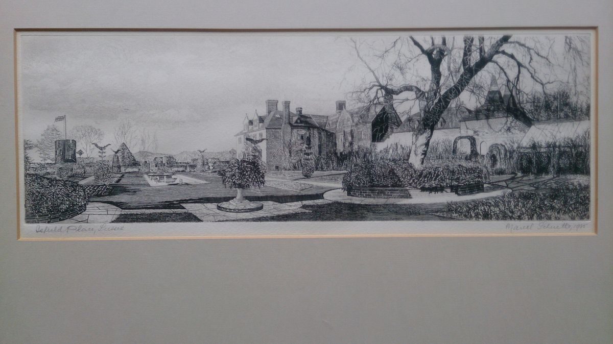
Isfield Place is a formal compartmentalised garden laid out from the late-19th century to the west and south of an Elizabethan manor house. There are surviving elements of garden and landscape features from the 16th century onwards.
Isfield Place stands on a natural prominence surrounded by the low-lying, ancient demesne land of the Manor of Isfield, approximately one kilometre north-west of the village of Isfield and about ten kilometres north-east of Lewes. The site, covering some 123 hectares is bordered to the west by the River Ouse, to the south by the River Uck, by Lodge Wood to the north and the Piltdown Road to the east.
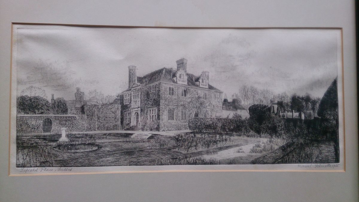
The house is set back from the road and screened by woodland, ornamental trees and hedged fields. It presents an imposing sight with turreted walling and bastions when viewed from the south-east, south and south-west, in particular from across the fields from Isfield church which stands 500 metres to the south-west of the house. Views from the house are south towards the South Downs over hedged fields under both grass and arable cultivation.
Isfield Place is approached from the west of the road leading north from Isfield village towards Piltdown and Fletching, with the main Lewes-Uckfield road (A26) about four kilometres to the east. The entrance is through imposing brick gate piers flanked to the north by a Gothic revival gate lodge constructed in brick with a tiled roof and stone mullioned windows. The lodge garden, mainly laid to lawn with fruit trees and a mature yew, is surrounded by a clipped yew hedge.
Immediately past the lodge the gravelled drive divides, the present-day approach leading to the north of the house as established by Henry King (shown on the 1874 Ordnance Survey map) through an arboretum (shown on the 1910 Ordnance Survey map). On exiting the arboretum a path leads south to the kitchen garden and north to the outbuildings and modern stable block.
The drive continues west for a further 60 metres before turning south through an arch in the stable block and culminating in a circular, gravelled turning area with a central grass island and ancient clipped yew tree. A small formal garden with low box hedges sits within a recess by the brick-built porch with flagstone floor, stone arch and heavy, timber double doors that leads into the house.
Almost certainly the 18th-century entrance did not turn north from the entrance but continued westwards to the south of the relic moat arm (now located 100 metres south-east of the house). It then skirted the southern side of the house before turning to give access to the principal, western front of the house via the gates set centrally within the western arm of the walled enclosure.
The first 150 metres of this road running along the moat remains is now a service road, turning north at a World War 2 pill box (now, 2004, in a dilapidated state) to the kitchen garden and garaging. The water (now, 2004, stagnant) of the moat arm is surrounded by a wooden post and wire fence, a row of four mature yews and rhododendrons in lawn lining its southern side, whilst a raised woodland walk on its northern side is bordered by mature oaks, hollies, yews, laurels and rhododendrons.
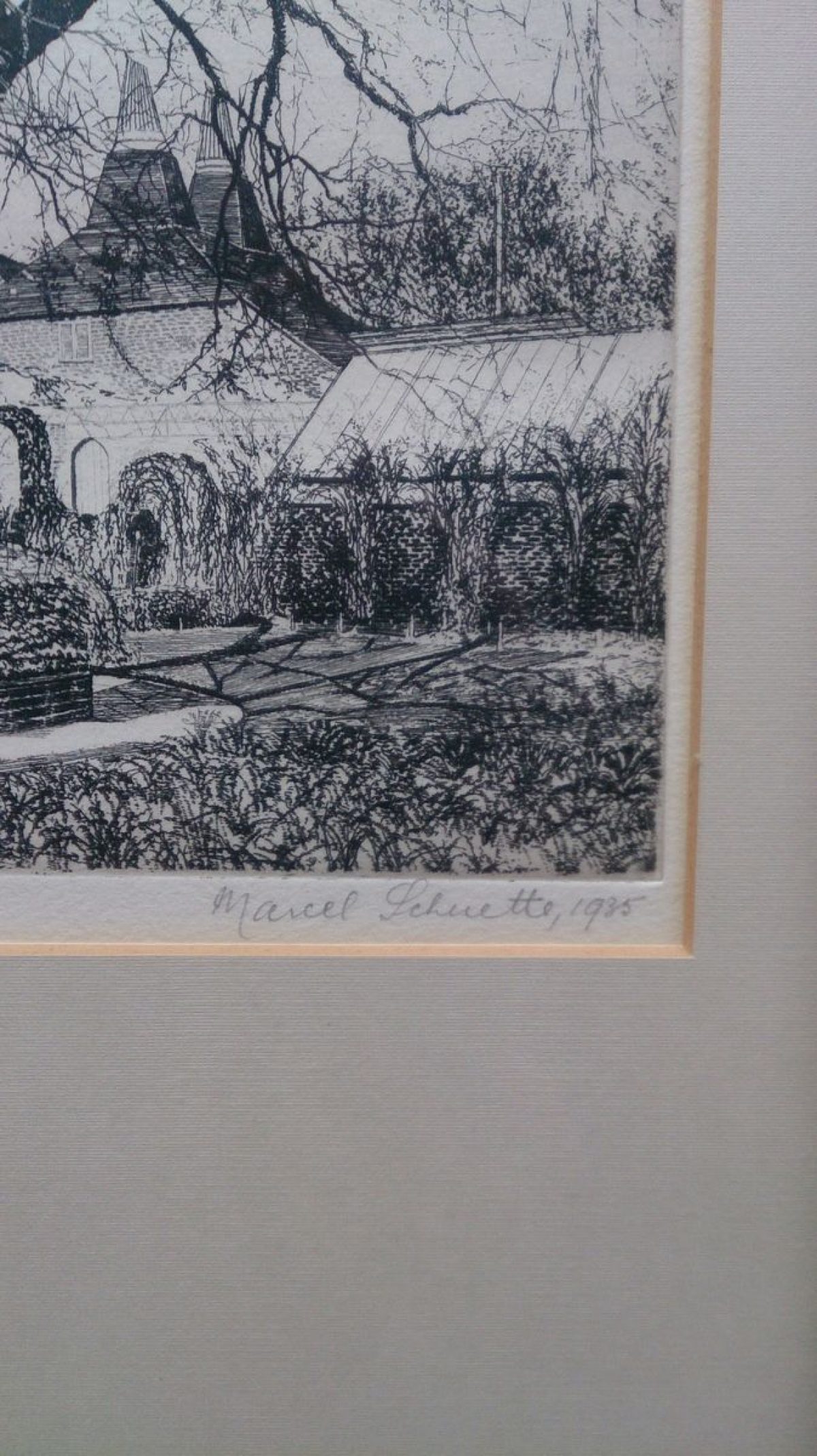
The gardens on the south and west of the house comprise a series of formal compartments divided by mellow red brick wisteria clad walls or clipped yew hedges and contained by the bastioned and turreted walls of the demolished 18th-century mansion. The brickwork in all the walls is built in English bond (alternate rows of headers and stretchers) with some laid in a diamond pattern.
The formal gardens, with views south over the fields to the church, are surrounded by informal lawns studded with mature trees on the west, north-west and north-east and by the kitchen garden on the east. From the south side of the house, the drawing room windows open onto a wide crazy paving stone path bordered by grass plats and shrubs, the cross path terminating on the west in a seating area enclosed by the ivy-clad ruins of the mansion walls, the east path leading into the topiary garden.
An assortment of mature clipped yew trees (probably 19th-century) offset by lavender bushes and standard roses border the two east-west York stone paths in the topiary garden. A rectangular stone lily pond with circular stone insets forming its curved ends is the central feature, whilst a second pool in an adjoining compartment to the west and shown in 1940s photographs has been filled in to form a flower bed. The topiary garden is enclosed by low yew hedges clipped into round shapes, a grass path on the south giving access to viewing points in the bastion wall.
At the east end of the garden wall enclosing the topiary garden on the south sits a two storey, octagonal, castellated watchtower incorporated into the garden design in the 19th century but now (2004) in a poor state of repair. There is a second turret dated 1880 with a timber flag pole at the western end of the wall, both watchtowers providing access through wooden doors and circular stone steps to the informal gardens.
Between the topiary garden and the house, on the site of an earlier glasshouse shown on Ordnance Survey maps from 1899, there is an outdoor heated swimming pool with diving board, electrically operated cover and flagstone surround (partly 20th century). The pool is screened from the garden by further clipped yew hedges, a lavender and rose bordered path leading from it to the house. To the west of the house is a sunken rose garden with wide, crazy paving stone paths, a central sundial and a five metre long lime tunnel underplanted with spring flowers. A door leads into the drawing room, above which is an ornately carved Shurley family coat of arms and architrave.
On the west side of the rose garden a low, two leaf double wrought iron gate leads down steps to a lawn, all-weather tennis court 20 metres west of the house screened by a high clipped yew hedge and north to a croquet lawn by two ancient oaks. The northern end of the north-south garden wall terminates in an octagonal brick summerhouse with thatched roof whilst at the southern end, where the garden wall abuts the west watchtower, an arch cut in a high yew hedge gives onto rough grass with daffodils and three ancient beech trees.
Below the formal garden to the south, the rose-covered red brick of the garden wall, three bastions and two buttresses (one incomplete) show evidence of repair, one section being stone. Photographs (1940s) show a deep herbaceous border running the length of the south wall fronted by a sunken path accessed by steps from each end (now, 2004, gone). Continuing south from the bastion a further expanse of rough grass has replaced an earlier putting green which ran down to a shallow ditch, possibly the remains of a ha-ha, now forming the garden boundary. The ha-ha is bordered on the north by three spaced yews planted on mounds with hedged agricultural fields on the south.
Immediately to the west of the farm buildings lie grass paddocks enclosed by wooden post and rail fences. Further west and to the north and south of the house can be seen the hedged field boundaries interspersed with trees as denoted on 18th-century maps, still largely used for pasture and agricultural land.
Running to Lodge Wood in the north is a double lime avenue (dattng from the 19th century) about half a kilometre in length (now, 2004, in poor condition). This divides the land to the north of the house, which is now principally arable production and 15,000 mixed hardwood trees.
The River Ouse on the west, (now, 2004, used for fishing sea trout, pike and other coarse fish), is fringed by woodland belts and copses, one containing a Victorian weir and fishladder (not seen). On the river bank is a small timber and tile boathouse (not seen). To the south of Isfield Church, now the Parish Church of St Margaret (Grade I), the river runs through grassland and water meadows. Twenty metres south of the church is the site of the motte and bailey castle (scheduled ancient monument).
Description written: March 2004
- Visitor Access, Directions & Contacts
Directions
The site is approximately one kilometre north-west of the village of Isfield and about ten kilometres north-east of Lewes.
- History
On the site of a motte and bailey castle, the Manor of Isfield (Sifelle) is recorded in the Domesday Book. Owned by the de Folkington family in the early-13th-century, Isfield was acquired through marriage by John de la Warr in 1243. His family retained it until 1427, when the property was inherited by John Griffin. In 1507 the Manor was bought by John Shurley, chief clerk of the kitchen to Henry VII, who probably replaced the original Tudor house with a new, partly-moated mansion on the present site to accommodate officials of the royal household. Isfield Church (12th-14th century) contains the Shurley chapel and monument to Sir John Shurley.
During the 18th century, probably under the ownership of the Radcliffes, Shurley descendants by marriage, the mansion was reduced to a farm house. Yeakell and Gardner‘s map of Sussex 1778-83 shows the house still intact, but a 1798 estate map shows an enclosure on the present garden site laid out in formal quarters and planted with trees. The estate was then tenanted and remained so until 1871 when the then owner, Henry King, converted the building for his own occupation. He made additions to the house and restored outhouses and garden walls, as confirmed by the 1st edition 25" Ordnance Survey map of 1874. He also rearranged the interior of the house, made the north front the principal approach and laid out a formal walled garden.
Changes by subsequent owners were made to the house. In the early-20th-century the enclosed gardens to the west and south of the house were transformed into an Arts and Crafts style ‘garden of rooms', shown with established planting in 1940s photographs. Later additions included a tennis court and swimming pool. The house and formal gardens with considerable pasture and arable land, modern and traditional outbuildings, remain in single, private ownership.
- Features & Designations
Designations
The National Heritage List for England: Listed Building
- Reference: Isfield Place
- Grade: II*
Style
Formal
Features
- House (featured building)
- Description: Isfield Place (listed grade II*), a large, irregular-shaped, two-storey house with attic, incorporates part of the 16th-century mansion of the Shurley family, the main portion being early-17th-century with a 19th-century wing on the north east. It is built of red brick with a tiled roof, stone eaves, cornices and casement windows with stone mullions and small square panes. Ground floor windows have obtusely pointed heads.Its principal elevation now faces north over the forecourt but it is likely that the mansion originally faced west, away from the road with a principal west front of around 39 metres in length. The relic moat arm to the south-east of the present house (and possibly the two shorter rectangular stretches of water ten metres to the north and north-east of the house, adjacent to the stable) indicate that the 16th-century house was at least partly moated.During the early to mid-18th-century, the mansion was reduced to a farm house by the demolition of the hall and parlour ranges, leaving only parts of the western walls standing as garden walls. The southern end of house was re-fashioned in Queen Anne style and the south front re-built to form a garden front as shown in Grimm?s watercolour of 1784. A 1798 estate map shows that at that date a range extended westwards from the northern end of the house to the northern wall of the garden.The white limestone Renaissance portico on the west front dates from around 1600 although it is not clear whether the portico was placed in its present location at the time or whether it originally formed part of a porch over the main entrance to the hall and was moved to its present location when the house was reduced in size during the early-mid-18th-century.
- Earliest Date:
- Latest Date:
- Garden Building
- Description: Two square oast houses (listed grade II), red brick with grey headers have been added on the eastern end of the mansion, probably in the 19th century. Both retain their cowls above a shared roof and now form covered parking for two cars, area for fuel storage and a modern 5000 litre oil tank. A further storage area and three rooms on first floor level are accessed via a timber, open tread stair.
- Earliest Date:
- Latest Date:
- Stable Block
- Description: Ten metres to the north of the house is a two storey stone and red brick stable (listed grade ll) now used as accommodation and office space. Built in the 18th to 19th century, with tiled roof and pointed casement windows it is shown in Grimm?s watercolour annotated as `the chapel now a stable?. A path leads from the stable to the farmyard 20 metres beyond and a cobbled courtyard flanked by brick and stone buildings comprising stables with two traditional loose boxes, four stalls, a tack room, coach house and well house with open well.
- Earliest Date:
- Latest Date:
- Garden Building
- Description: There are also other farm buildings including a granary and Sussex barn.
- Kitchen Garden
- Description: The 19th-century (shown on the 1874 Ordnance Survey map) stone and brick walled kitchen garden (around 20 metres x 20 metres) lies to the east of the formal gardens. 20th century additions within the garden include several raised beds, two greenhouses (one containing a grapevine), espaliered fruit trees and garden stores. The remains of cold frames and further planting form an adjoining area outside the walls on the south.
- Earliest Date:
- Latest Date:
- Planting
- Description: The gardens on the south and west of the house comprise a series of formal compartments divided by mellow red brick wisteria clad walls or clipped yew hedges and contained by the bastioned and turreted walls of the demolished 18th-century mansion.
- Gate Piers
- Description: The entrance is through imposing brick gate piers.
- Gate Lodge
- Description: Gothic revival gate lodge constructed in brick with a tiled roof and stone mullioned windows.
- Drive
- Description: Gravelled drive.
- Tree Feature
- Description: Arboretum.
- Specimen Tree
- Description: Ancient clipped yew tree.
- Dry Moat
- Description: Relic moat arm.
- Border
- Description: An assortment of mature clipped yew trees (probably 19th-century) offset by lavender bushes and standard roses border the two east-west York stone paths in the topiary garden.
- Earliest Date:
- Latest Date:
- Ornamental Pond
- Description: A rectangular stone lily pond with circular stone insets forming its curved ends.
- Planting
- Description: The topiary garden is enclosed by low yew hedges clipped into round shapes, a grass path on the south giving access to viewing points in the bastion wall.
- Tower
- Description: Two storey, octagonal, castellated watchtower incorporated into the garden design in the 19th century but now (2004) in a poor state of repair.
- Tower
- Description: There is a second turret dated 1880 with a timber flag pole at the western end of the wall
- Earliest Date:
- Latest Date:
- Outdoor Swimming Pool
- Description: Outdoor heated swimming pool with diving board.
- Rose Garden
- Description: To the west of the house is a sunken rose garden with wide, crazy paving stone paths, a central sundial and a five metre long lime tunnel underplanted with spring flowers.
- Sundial
- Description: There is a sundial in the rose garden.
- Croquet Lawn
- Specimen Tree
- Description: Two ancient oaks.
- Summerhouse
- Description: Octagonal brick summerhouse with thatched roof.
- Ha-ha
- Tree Avenue
- Description: Running to Lodge Wood in the north is a double lime avenue (dating from the 19th century) about half a kilometre in length (now, 2004, in poor condition). This divides the land to the north of the house, which is now principally arable production and 15,000 mixed hardwood trees.
- Earliest Date:
- Latest Date:
- River
- Description: River Ouse.
- Boat House
- Description: On the river bank is a small timber and tile boathouse.
- Gardens
- Key Information
Type
Garden
Purpose
Ornamental
Principal Building
Domestic / Residential
Survival
Part: standing remains
Hectares
123
Open to the public
Yes
Civil Parish
Isfield
- References
References
- (Harmondsworth: Penguin, 1965) 545 The Buildings of England: Sussex
- Horsfield, Thomas Walker {The History, Antiquities, and Topography of the County of Sussex. [With plates and maps.] Volume 1} (Lewes: Sussex Press, 1835) 371-3 The History, Antiquities, and Topography of the County of Sussex. [With plates and maps.] Volume 1
Contributors
Barbara Simms
Sussex Gardens Trust