Introduction
The designed landscape associated with the mid-18th-century house at Hatchlands consists of parkland (probably originating in the late-17th century) improved by Humphry Repton in the early-19th century. There are also gardens and pleasure grounds. There are features dating back to the mid-18th century and an early-20th-century formal garden by Gertrude Jekyll.
Terrain
The topography of the parkland is not dramatic, although from its highest ground, south of Little Wix Wood, there are long views back to the house and notably northward towards Windsor and Slough.www.historicengland.org.uk/listing/the-list
Park with probably late 17th-century origins, improved following the commissioning of a Red Book from Humphry Repton in 1800, associated with a Grade I listed house. Its gardens and pleasure grounds include mid-18th-century features and a formal garden of 1900 by Gertrude Jekyll.
DESCRIPTION
LOCATION, AREA, BOUNDARIES, LANDFORM, SETTING
Hatchlands stands east of the village of East Clandon, and 7km east of Guildford. The land here registered, a roughly triangular area 1.5 km from north to south, covers c115ha. To the south the boundary is provided by Epsom Road, the A246 from Guildford to London. The other boundaries follow field edges, meeting at the northern tip of the park which abuts the London-Guildford railway. This defines what in the C19 and C20 has been the principal parkland; it excludes land added to the park down its east side c1909 by H S Goodhart-Rendel (see below, Entrance and Approaches). The topography of the parkland is not dramatic, although from its highest ground, south of Little Wix Wood, there are long views back to the house and notably northward towards Windsor and Slough.
ENTRANCES AND APPROACHES
Before c1911, when the old London road was closed, the main approaches were from the south-west and south-east corners of the park. Although the former approach apparently already existed on approximately this line, Repton's suggested improvements of 1800 at Hatchlands included setting out these drives through the park, each with views of the house framed by trees. About 1820 a mock-Tudor lodge was built at the western entrance to the park; later this was extended and renamed Fullers Farmhouse. Lodge (or Gardener's) Cottage, to its west, a two-storey tile-hung house, replaced it as the lodge c1900. At about the same time Wix Hill Lodge, a single-storey red brick structure in the style of the main house, was built at the east entrance. From the lodges, drives arc northward to meet at a point north of the house. Previously a third drive also arrived here, approaching via a cut through Great Wix Wood from the Hatchlands (or Station) Lodges on the west edge of West Horsley. This was planned in 1909 by H S Goodhart-Rendel to provide a more direct route to West Horsley railway station, and to allow the parkland to be expanded to the east. At the end of the drive is a small pair of identical, two-storey brick lodges - cube-like, with hipped slate roofs around a central chimney - of 1913 designed by Goodhart-Rendel. These stand either side of large, wrought iron gates, also of 1913, modelled on those at nearby Clandon Park (qv). This drive is now discontinuous, and the lodges lie beyond what in the C19 and C20 was reckoned to be the eastern limit of the park, here taken as the edge of the registered area (although the drive outward to the lodges and the structures themselves are included as outliers). The main visitors' entrance, constructed 1991, is now off the Epsom Road close to the south-west corner of the park. This runs east and then north to a large car park against the west side of the kitchen garden.
In the Boscawen's time the main, and perhaps only, approach to the house was a straight approach from East Clandon to the west. This was later modified, and Lindley's 1793 map suggests that the approach adopted by Repton from the south-west was in existence.
PRINCIPAL BUILDING
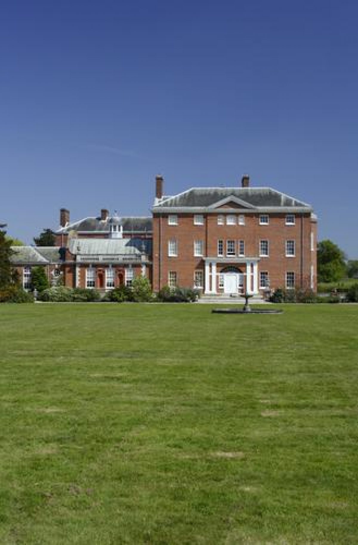
Hatchlands (listed Grade I) was built c1756-60 by Admiral Boscawen, a younger son of the first Viscount Falmouth. His architect was Stiff Leadbetter (d.1766). Robert Adam (1725-92) advised on the house's decoration, one of his earliest English country house commissions. That house, of brick under a slate roof, originally had its main entrance on the west front; here the house is of two storeys and an attic, of seven bays with the three, narrow, bays to the centre breaking forward beneath a pediment. About 1890 the main entrance was switched by Stuart Rendel to the east where a porch was added; here the façade is of two storeys, with full-height canted bays to either side, a feature repeated on the centre of the south front. To the north are service ranges and the stables (below). As well as altering the entrance front some remodelling of the interior also occurred in the time of Stuart Rendel's ownership, especially after he became Lord Rendel; a new east entrance and dining room were contrived, and a Music Room in the manner of Christopher Wren to the design of Sir Reginald Blomfield, its decoration part of a more general enlivenment of the original Adam scheme. Something of the original austerity of the decoration was recovered by his heir H S Goodhart-Rendel.
To the rear (north) of the house is a red brick stable block and service court (listed Grade II) of 1889 by Halsey Ricardo, Lord Rendel's nephew by marriage.
GARDENS AND PLEASURE GROUNDS
The main garden front is today to the west, where a formal, flagged and balustraded terrace was constructed c1890 when this ceased to be the entrance front. This looks out onto a lawn with central C19 fountain (traces of flower beds around this, grassed over in 1960, can be seen in the lawn), and over a railed fence to the gently rising parkland beyond. To the south of the house is a small formal garden, one of two designed in 1900 by Gertrude Jekyll, to whose house at Munstead Wood the young Hal Goodhart-Rendel had bicycled for tea (proposals for the west of the house were apparently only partially carried out). This south garden, apparently originally known as the Dutch Garden, received a revised planting plan by Jekyll in 1914. It still follows Jekyll's plan but now comprises box-edged beds around low palms, with the whole defined by a low stone balustrade (under restoration 2007).
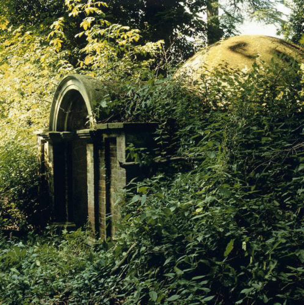
About 100m south of the Jekyll garden, on a slight rise, is a C18 garden temple (listed Grade II), a circle of Doric columns on a stepped base beneath a copper-domed roof, moved to Hatchlands in 1953 from Busbridge Hall (Surrey). Just east of this is the Dell, probably a former quarry, already planted as a flower garden in the late C18. Today it is largely scrubby woodland although terraced, flint-lined, paths can be picked out. Set in its east side is a probably mid-C18 icehouse with a brick façade of c1900 (listed Grade II). Running east-west behind this, along the north side of the old London road, is a narrow sunken way, the Boscawens' New Walk of the earlier 1750s (below).
The historic sources indicate that the Boscawens were landscaping around the old house from soon after they arrived in 1751, and by 1755 there was a New Walk with lilacs, roses, thorns and laburnums and had benches and a thatched tea-house set along it. Repton's description of the place in 1800 suggests it may have run from the large quarry (where Repton mentions a flower garden) to the south-west of the house and then alongside the London road (the surviving length, noted above). Seven hundred plants were added to the New Walk in 1756. In 1757, as the new house was going up, they planted 'Caroline poplars' (balsam poplars), pines and laurels around it, along with a group of Scots pines near the south-east corner of the house, which survived until the 1950s. Humphry Repton was commissioned in 1800 to produce a Red Book for the property, and it appears most of his proposals were carried out. A 'dressed lawn or pleasure ground' was to be laid out around the house; gravel walks constructed leading to 'certain objects which might interest the attention and thus display the house and the place to the greatest advantage'; the 'flower garden in the dell' and the 'shady walk near the house' were preserved from the earlier garden.
PARK
The park is now permanent pasture. In the southern half of the park are large numbers of mature trees, mostly oaks, with some veterans west of the western drive to the house. The National Trust suggests that the older trees may date from the Boscawens' time, although it would seem equally likely they stood in the park documented in 1693 (below). Great Wix Wood stands in the centre of the park, and Little Wix Wood on its eastern border; both are mixed deciduous woodand, mostly young although there is one notable veteran oak where the former drive leaves the west side of Great Wix Wood. Northward of Great Wix Wood there are few trees other than in the Long Walk which runs around its perimeter. Along the former line of the London road are some mature beech trees; beyond there has been much planting in the recent past in an attempt to screen off the A246. This includes Centenary Wood, planted in 1995 to mark the centenary of the National Trust.
A small park had been created around Hatchlands by 1693, somewhat smaller than the later park. By c1761 (as perhaps from its creation) its east boundary followed the parish boundary, now marked by the straight north-south field boundary 350m east of the house (no sign of a pale is visible). The Boscawens probably made some improvements to the park in the 1750s; in 1756, for instance, considering making a fir plantation. This may have been the western part of Wix Wood, called Louisbourg Grove on early C19 maps and named after Admiral Boscawen's most famous victory, the capture of Louisburg in 1758 which preceded the fall of Quebec and the capture of Canada for Britain. Further changes to the woodlands around Hatchlands came after the estate's sale to William Sumner in 1770 as he invested heavily in grubbing up a large area of coppice woodland, presumably that which Rocque's map of 1761 shows occupying all of the present parkland north of Wix Wood. Repton's Red Book of 1800 saw the main problem at Hatchlands as the London road which ran close to the house, between it and the walled garden. Apparently its removal was not an option, and he proposed instead to screen off the road and the kitchen garden beyond using a mound and shrubs, and to open up views west from the house by some limited felling. Only in Lord Rendel's time in 1911 was the road finally moved to its present alignment leaving the old road as a track lined, in the vicinity of the kitchen garden, with mature, possibly early C19, limes. Another change in Rendel's time was the infilling of Grotto Pond, a large rectangular pool 150m west of the house; its name suggests an otherwise unrecorded C18 parkland feature. A mound visible on the skyline from the house may be associated with Grotto Pond.
KITCHEN GARDEN
The walled kitchen garden stands 150m south the house, originally separated from it by the London Road. Overall it is roughly rectangular, and measures c50m east-west by c150m north-south. That along the north side curves inward to the top, has decorative coping and an elaborate central gateway into the garden with ball finials atop rusticated piers. A gardener's house of 1889 and ranges of sheds (all tenanted; not inspected) stand along the outside of the north wall. The interior of the garden was down to pasture in 2007. The walled garden was already here by c1761 when Rocque's map was surveyed, and its walls probably predate the Boscawens' ownership of the place.
REFERENCES
C Renow-Clark, Hatchlands: Restoration Scheme Research (report for the National Trust, 1992)
K Fretwell, Hatchlands: Park and Garden Survey (National Trust 1990)
J Lees-Milne, People and Places (1992) caption 14
Hatchlands Park (National Trust guidebook, 2002)
Maps
OS 25" to 1 mile: published 1870
OS 6" to 1 mile: published 1873, 1897, 1919
Various historic maps from the late 17th century onwards are reproduced in the two reports for the National Trust noted above.
Description written: March 2007
- Visitor Access, Directions & Contacts
Telephone
441483222482Access contact details
Park walks open daily throughout the season. The house and garden are open at more restricted times. For details please see: http://www.nationaltrust.org.uk/place-pages/162/pages/opening-times-calendar
Directions
Hatchlands is 7km east of Guildford and just east of the village of East Clandon.
- History
The following is from the Register of Parks and Gardens of Special Historic Interest. For the most up-to-date Register entry, please visit the The National Heritage List for England (NHLE):
www.historicengland.org.uk/listing/the-list
HISTORIC DEVELOPMENT
In the Middle Ages Hatchlands, which had a moated capital messuage in 1307, belonged to Chertsey Abbey. At the Dissolution it passed to Sir Anthony Browne, remaining in his wife's family until sold in about 1700. In 1749 the property was bought by the naval hero Admiral the Hon. Edward Boscawen (1711-61), who moved here with his wife in 1751 to the old Tudor house where they were to live for the first ten years of their ownership, apparently beginning landscaping soon after they moved in. In 1756 they decided to have a new red brick house, employing Stiff Leadbetter and Robert Adam to build and decorate it. This is the present house. The Boscawens' enjoyment of their new house was but brief; in 1761 the Admiral died and in 1770 his widow sold Hatchlands to William Brightwell Sumner (died 1791), who had made a fortune in the East India Company. In his family's time minor alterations were made to the house by Joseph Bonomi and improvements made to the grounds by Humphry Repton who was commissioned in 1800. Most of his proposals for improvements to the landscape and house were modest, presumably reflecting his client's aspirations and purse, and were carried out, although not his suggestion to stucco the house. In 1888 Hatchlands was sold to Stuart Rendel (1834-1913), a wealthy industrialist and Liberal MP who was raised to the peerage as Lord Rendel of Hatchlands in 1895. In his time various changes were made both to the house and its surrounds, including the commissioning of new gardens from Gertrude Jekyll and the closure of the old London road which passed within 150 metres of the house and its replacement by the present A246. On his death in 1913 Hatchlands passed to his grandson, Harry Stuart Goodhart-Rendel (1887-1959), architect and soldier. He gave Hatchlands to the National Trust in 1945, who retains ownership today (2007).
- Associated People
- Features & Designations
Designations
The National Heritage List for England: Register of Parks and Gardens
- Reference: GD5311
- Grade: II
Features
- Parterre
- Description: The south parterre, designed by Gertrude Jekyll and restored by the National Trust.
- House (featured building)
- Description: In 1756 a new red brick house was commissioned, employing Stiff Leadbetter and Robert Adam to build and decorate it. This is the present house.
- Earliest Date:
- Latest Date:
- Key Information
Type
Estate
Purpose
Ornamental
Principal Building
Heritage Site
Survival
Extant
Hectares
115
Open to the public
Yes
Civil Parish
East Clandon
- References
References
- {English Heritage Register of Parks and Gardens of Special Historic Interest}, (Swindon: English Heritage, 2008) [on CD-ROM] Historic England Register of Parks and Gardens of Special Historic Interest
- Fretwell, Katie {Hatchlands: park and garden survey} (1990) Hatchlands: park and garden survey
- The Landscape Agency {Hatchlands Park Conservation Management Plan} (2009) Hatchlands Park Conservation Management Plan