Introduction
Wotton House has Italian gardens of around 5 hectares. It was the family home of Evelyns, and is now a conference centre.
Terrain
The ground at Wotton slopes generally from the west and east into the central valley bottom, and from the south towards the north, before rising again to the north of the house.
The following is from the Register of Parks and Gardens of Special Historic Interest. For the most up-to-date Register entry, please visit The National Heritage List for England (NHLE):
Location, Area, Boundaries, Landform and Setting
Wotton House and its surrounding grounds of c 20ha as here registered, is located in the valley of the River Tillingbourne, 4km west of Dorking, in the county of Surrey. The site is bounded by open land and Manor Farm to the north and north-west, Damphurst Wood and Bushy Wood to the east, Millpond Copse to the south, and Mundies Plantation and Whitings Wood to the west. The ground at Wotton slopes generally from the west and east into the central valley bottom, and from the south towards the north, before rising again to the north of the house (outside the area here registered). There are good views from the artificially made higher ground in the centre of the gardens, to the west and east over the pleasure grounds, and north towards the House. The boundaries are marked by a mixture of walls and fences.
Entrances and Approaches
Wotton House is approached from Guildford Road (A25) to the north, from where the North Drive leads past the North Lodge (c 1850, listed grade II), on the east side of the drive, southwards and then curving westwards for c 800m to the House approach. A second drive from the west, past the West Lodge, is (2000) no longer used. This drive is terraced and leads directly eastwards for c 400m to the House approach. These two drives were laid out in c 1850, replacing the straight C17 approach from the north, which was aligned on the House. The two drives meet c 100m to the north of the House, from where a drive leads south, through entrance gates with a C19 lodge on the west side, and down a straight formal approach between walls to the turning oval on the north side of the House. This section of the drive existed in the C17 but the treatment, with gates, lodge, walls, and turning oval, is C19.
Principal Building
Wotton House (listed grade II*) was built in the late C16 for the Evelyn family. It was extended in the later C17 and to the east in the C18 by William Kent (1685-1748). The House was further extended and altered in the early C19 by Francis Edwards and restored (following a fire) and enlarged by Henry Woodyer for William John Evelyn in 1877. The entrance or north front has two storeys and is built around three sides of a courtyard, with a two-storey porch to the centre. The east side of the House has three storeys. The exterior is clad with brick and terracotta decorations on the entrance front, and with a cement render to the south or garden front. To the south-east side of the House is an C18 orangery, extended in 1877 when the decorative parapet and banded piers were added.
Gardens and Pleasure Grounds
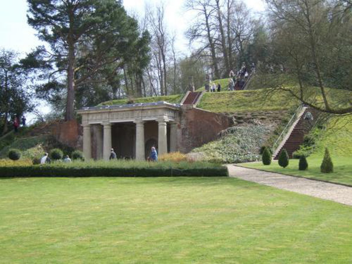
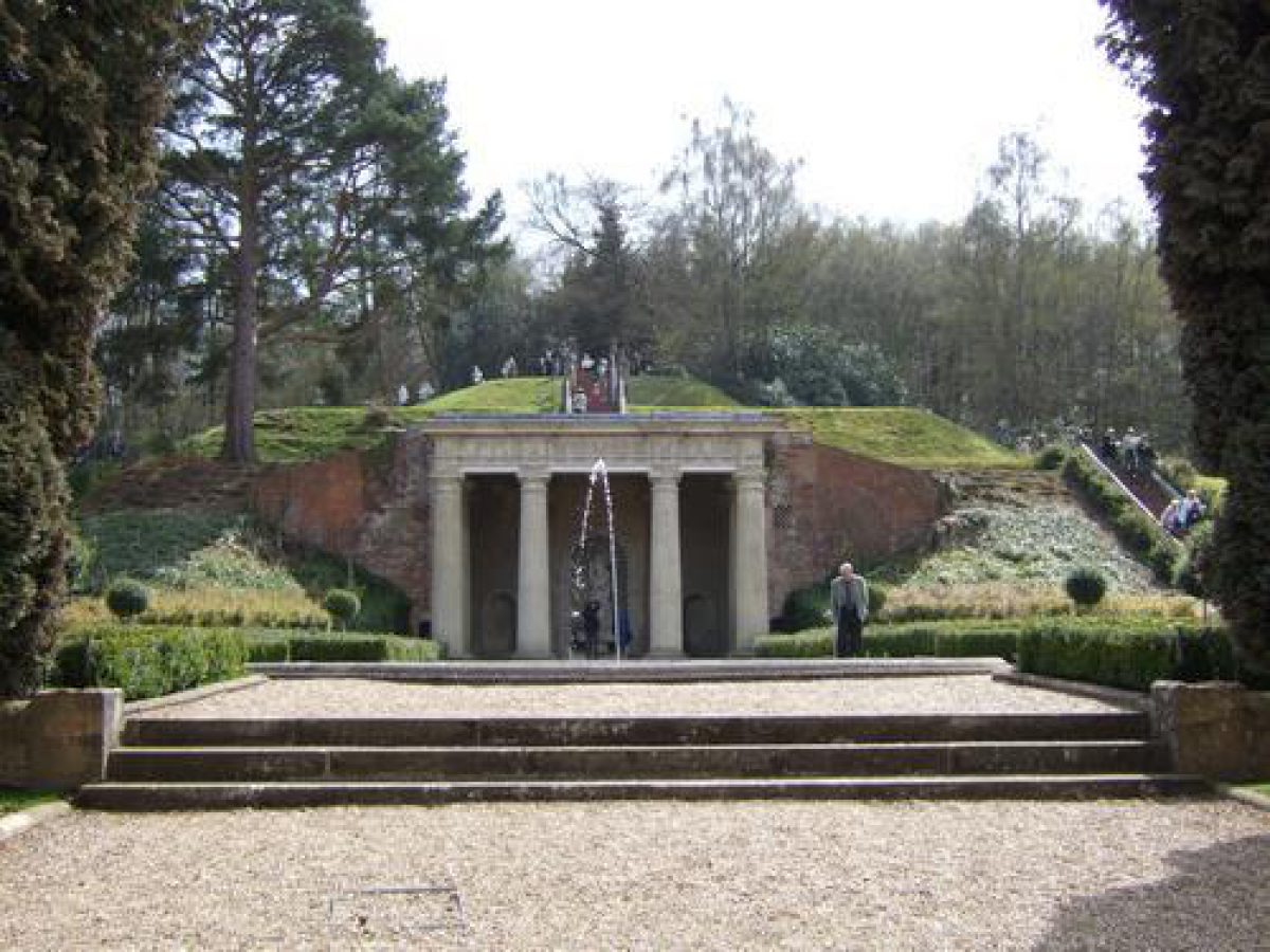
A paved terrace lies to the south of the House, overlooking a formal garden to the south and bounded by low brick walls decorated with a fish-scale pattern in clay half-round tiles. A terrace was extant in 1640, pre-dating the alterations to the garden by John Evelyn. This was probably removed in the mid to late C18 when the gardens were simplified and by the early C19 a lawn ran up to the south front of the House. The terrace was restored in the mid to late C19 by William John Evelyn. A pair of brick gate piers with wrought-iron gates are aligned on the centre of the south front, beyond which a series of features are seen, rising one above the other: a fountain, with a temple beyond, and above it a mount. A wide axial path leads from the terrace to a late C19 fountain basin. The path is edged in stone with rope-edge detail, in a similar pattern to that used on the fountain basin, which has a double rim incorporating an inner planting bed and rockwork at the centre, formerly decorated with conch shells (CL 1898). The circular fountain and axial path were features of the mid C17 layout by John Evelyn and were at the centre of a parterre. The parterre and path were removed in the C18 but the path was restored and a new fountain basin (replacing the mid C17 one by John Evelyn) installed in the late C19, with peripheral planting beds for rhododendrons and azaleas. This planting survives but the shrubs have outgrown their beds. A temple (listed grade II) lies c 10m to the south of the fountain, set into the hillside to the south. It is built of stone, with stone paving and earth covering the roof, and has four giant Doric columns supporting a triglyph frieze and entablature. Around the walls of the temple are arched niches, the centre one containing a statue of Venus and a fountain basin. A temple was built on the site by George Evelyn in c 1649, but it was restored and rebuilt in the C18 and later.
To the west and east of the temple the ground is graded into steep slopes which are planted with yew and other trees. Paths in a horseshoe shape curve south from either side of the fountain and up a flight of steps on either side of the temple. From this level, two flights of steps lead up the centre of the north side of a terraced mount, formed from a hill in 1652. This path layout probably dates from the mid to late C18 and replaced the mid C17 retaining walls, through which the Mount was approached by an arched entrance on either side. The Mount is backed by woodland to the south but is open to the west and east, from where the grass sides descend in terraced steps (now only in four terraces but in the mid C17 there were five: three smaller, lower terraces and two larger, upper terraces). The summit of the Mount is levelled and statues of the Four Seasons are placed on either side of the upper steps (in this position by the late C19, CL 1898). A conduit for the fountain runs along the east side of the Mount, on one of the terraces, and terminates on the south side of the temple roof. The leat dates from the mid C17 but was lined with red bricks in the C20.
To the west of the Mount is an area of open lawn, bounded by a C17 garden wall to the south and west, which runs west from the south side of the Mount and then north, up the west side of the garden. The lawn has clumps of shrubs and scattered mature trees and is backed to the west by a belt of trees. Within this belt and adjoining the west boundary wall is a walled garden which dates from the late C18 or early C19 and was shown on the plan by Landsell of 1818. Keane (1849) described it as a 'geometric flower garden, laid out on gravel, edged with box, and surrounded by walls'. Within the enclosure is a garden building known as the Tortoise House (listed grade II). It was probably built in the late C19 and is a rectangular building of Portland stone, rubble stone, and brick, with the remains of a wooden superstructure and tiled roof. The ground floor has four bays with Ionic columns supporting an architrave frieze and the upper storey, now (2000) collapsed, had open sides divided into bays by thin wooden piers. A rectangular sunken tank is located at the centre of the enclosure to the north of the Tortoise House, and was probably intended for turtles or terrapins rather than tortoises. The enclosure was marked as an aviary on the OS maps of 1872 and 1896.
To the north-east of the Tortoise House and c 15m south-west of the House, are the remains of a glazed fernery, built in artificial stone, with planting pockets, stalactites, and hot water piping. Only the end wall survives (listed grade II) but in the gardens immediately to the west are further areas of rockwork along the path edges and a free-standing arch, formed of artificial stone and rubble composite with an earth and rubble roof. The glazed fernery and another glazed building (demolished by late C20), c 5m to the east, were shown on the 2nd edition OS map of 1896.
A serpentine channel of the Tillingbourne runs through the small area of garden to the west of the House. There was a pond in this area, shown in a drawing by John Evelyn dated 1640, which was drained in the mid to late C19. The stone retaining walls from the pond survive but the northern half of the pond has been filled in and is now a tarmac car park, associated with the adjoining C20 buildings (now, 2001, demolished) on the west side of the House.
The River Tillingbourne runs from east to west to the north of the House. It is canalised along the length of the House, the sides retained with stone revetments. The Tillingbourne was shown in its present form in mid C17 sketches, and was possibly a moat prior to the mid C17 alterations.
To the north of the Tillingbourne are two enclosed gardens, one on either side of the main approach. To the west is the Lodge Garden, largely built over by a C20 lecture hall (now, 2001, demolished) and car park. The garden was enclosed and laid out by William John Evelyn as part of the work on the main approach. In the equivalent space on the east side of the drive is the Irish Garden, enclosed with low walls and with a late C19 fountain basin to the west of centre, now (2000) empty of water. Formal paths, now mostly grassed over but still visible, run around the edge of the garden, with additional straight paths crossing the gardens at the fountain. Until the mid C19 this area was part of the park lying on the north side of the House. The garden was enclosed and laid out at the same time as the Lodge Garden.
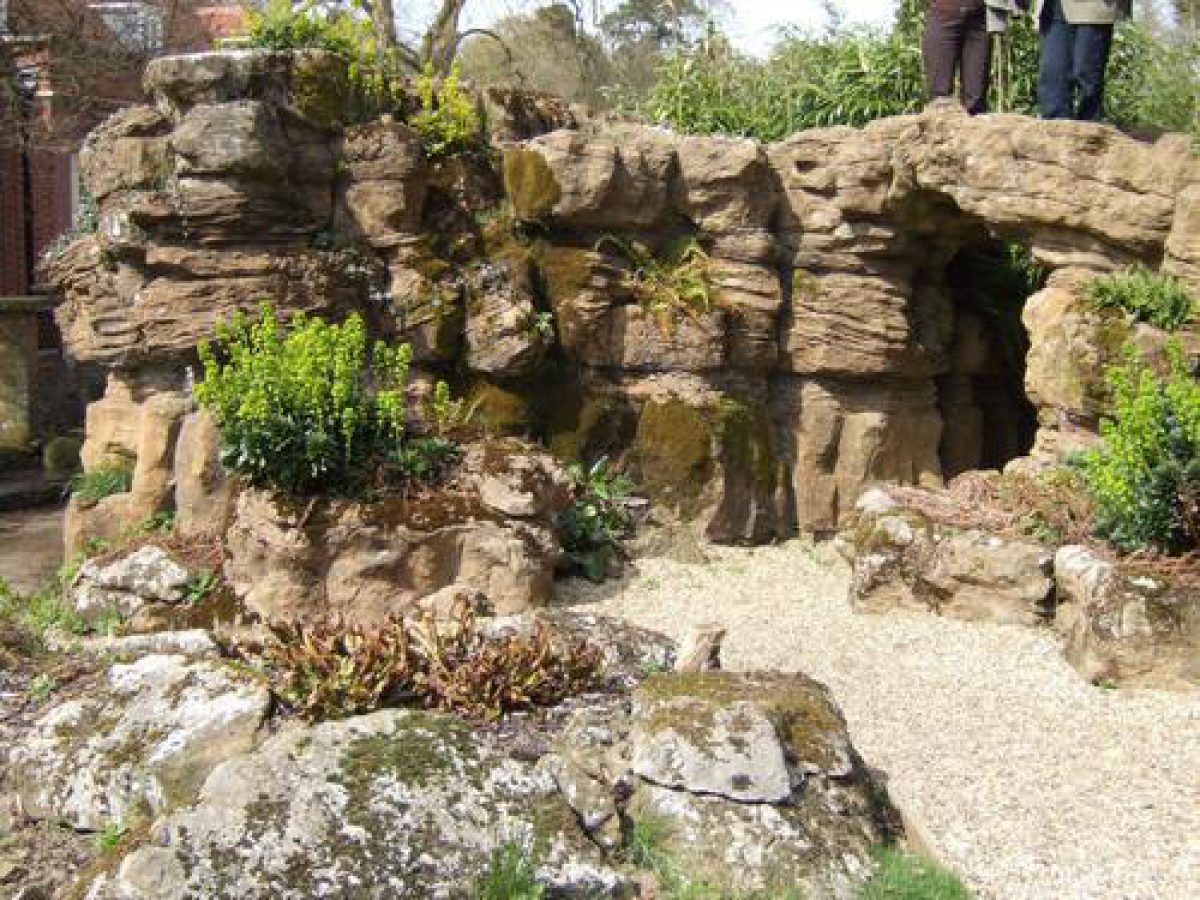
Near the north-east corner of the House the Tillingbourne is joined by a canalised stream that runs along the east side of the gardens. The terrace on the south side of the House continues around the south-east corner of the House and up its east side. The east terrace is bounded by a continuation of the terrace wall that runs alongside the stream, which is edged with artificial stone. At the south-east corner of the terrace the stream forms a pool, again edged with artificial stone. An artificial stone bridge crosses over the stream, connecting the terrace with a small area of garden to the east of the stream, the northern end of which is occupied by a substantial free-standing Pulhamite grotto (listed grade II), formed of sandstone rubble with artificial cement and earth roof. There are two main entrances to the grotto, which has two chambers inside. Steps lead up the north side on to the top of the grotto. An ornate fountain basin, with central rockwork around the fountain, lies c 20m to the south of the grotto in an area laid out in the late C19 as a garden, the paths and beds now largely grassed over. The eastern boundary of the gardens is defined by a late C19 wall. Prior to the construction of the wall, the stream marked the eastern edge of the garden.
Park
From the north drive, a track leads south to an area of open grassland with scattered trees, bounded to the west by the garden and to the east by Damphurst Woods. To the south is a c 10ha area of ornamental meadow, bounded by woodland on all sides and with a stream running from south to north up the centre. The stream is dammed to form a series of ponds, linked by cascades. This area was laid out by Sir John Evelyn in the early C18. The work included forming a serpentine 'new river', with cascades along a one mile stretch. The river was described by Manning and Bray (1809) and by Keane (1849), who referred to fifteen waterfalls along the stream. On the north-west side is an area of open ground, lying immediately south-east of the Mount, which had kangaroo and deer paddocks in the late C19 and early C20 (OS 1896, 1914).
Walled Garden
The C18 kitchen garden is located c 200m north-east of the House on ground sloping southwards. The garden is two parts: an inner, rectangular area on the south side, with an outer walled area to the west, north, and east. This outer area was extended to its present size in the late C19. The garden is walled on all sides and there are two cottages, Quarry Cottage on the west side, and Gardener's Cottage, on the east side. The garden and cottages are privately occupied but the kitchen garden is now (2000) no longer used for cultivation.
Other Land
Within the estate (but outside the area here registered) are a number of landscape features including: an icehouse in Damphurst Wood to east of the gardens; a pond, 200m to the west of the House and 20m to the south of the west drive; an early C19 pedimented stone Mausoleum, 1km to the west of the House; and c 60ha of woodland to the west and east of the park, with the remains of radiating rides from an eight-point star in Damphurst Wood, extant by 1720.
Maps
- John Rocque, Map of Surrey, surveyed c 1762, published 1768 I Landsell, Estate Survey, 1818 (in Colson Stone 1997)
OS 6" to 1 mile: 1st edition surveyed 1869-70, published 1873 OS 25" to 1 mile: 1st edition surveyed 1870, published 1873 2nd edition published 1896 3rd edition published 1914
Illustrations
- J Evelyn, Drawings, 1640, c 1652, 1653 (in Colson Stone 1997, figs 2-4, 6) John Aubrey, Watercolour, late C17 (in Colson Stone 1997, fig 7) George Lambert, Painting, 1739 (in Colson Stone 1997, fig 5)
Description written: February 2000
Amended: July 2001
Register Inspector: CB
Edited: April 2003
- Visitor Access, Directions & Contacts
Website
https://wottonhouse.co.uk/Access contact details
Hotel and Conference centre.
Directions
The site is on the A25 between Dorking and Guildford. There is also a railway station in Dorking.
Owners
Hayley Conference Centres
Principal House, 11 Ripon Road, Harrogate,, HG1 2JA
- History
The following is from the Register of Parks and Gardens of Special Historic Interest. For the most up-to-date Register entry, please visit The National Heritage List for England (NHLE):
Mid C17 gardens by John Evelyn and George Evelyn, with early to late C19 alterations.16th - 17th Century
In 1579, the Wotton estate was sold by its owner, Henry Owen, to George Evelyn (d 1603). He was succeeded by Richard Evelyn who died in 1640, leaving three sons: George (d 1699), who inherited Wotton House, John (1620-1706, the author of Sylva), who inherited Sayes Court; and Richard, who inherited Woodcote House. The gardens of Wotton were recorded in 1640 by George's brother, John, in two sketches (described in VCH 1911). Early improvements were made to the gardens by John, who was influenced by the Italian Renaissance gardens he had seen on his tour of Italy in 1644-5.
By 1649, George had constructed a temple in the garden, designed by his cousin, Captain George Evelyn, and in 1650, John returned to Wotton to advise his brother on further improvements, which included an artificially terraced mount, a fountain, and a parterre garden on the site of an earlier moat, which was filled in. The work was recorded in a sketch by John, dated 1653. John continued to make minor improvements to Wotton, including planting an evergreen grove in 1696/7, and in 1699 inherited the property on the death of his brother. His final improvement was the addition of an orangery on the east side of the south front of the house, built in 1704. He was succeeded by his grandson, John (1681-1763, created a baronet in 1713). Sir John Evelyn preserved the temple, fountain, and mount but laid out a more informal landscape around them.
The kitchen garden was moved from its C17 location to the east of the gardens, to a site north-east of the House, and an informal river with a series of cascades was formed to the south-east of the gardens in the 1740s.
18th Century
In the mid to late C18, the formal parterre and terrace to the south of the House were removed by Sir John (1st Bt), or his son, also Sir John (2nd Bt, owner 1763-7), or his son, the 3rd Bt, Sir Frederick (d 1812), who inherited in 1767. Wotton passed in 1812 to Sir Frederick Evelyn's widow and then on her death in 1817, to John Evelyn (d 1827), of the Godstone branch of the family. John commissioned I Landsell to prepare a survey of the estate in 1818, which depicts the garden and landscape at this date.
19th Century
The main features of the formal landscape had been retained but much of the detail had been removed and replaced by informal planting. On his death, the property passed to his son George (d 1829), and then, after a minority of fourteen years, to George's eldest son, William John Evelyn (d 1908), in 1843. William John Evelyn restored Wotton House in the 1860s and carried out extensive alterations to the gardens. These included the reinstatement of the terrace to the south of the House, which was extended to the east; new paths and planting around the fountain and temple; a formal approach across the Tillingbourne from the north; an Irish Garden to the north-east of the House; and various animal paddocks including a deer paddock and a kangaroo paddock (OS 1896).
20th - 21st Century
William John Evelyn died in 1908, but the property had been made over to his son, John Harcourt Chichester Evelyn, c 1900. The House was used by the Canadian Army during the Second World War and in 1947 Mr C J A Evelyn leased it to the Home Office for use as a fire training centre. It became the national headquarters of the Fire Service College, and new buildings were erected around the service buildings on the north-west side of the House, including a hall and accommodation block with a car park in between.
In 1981, the lease was assigned to British Telecom who remained at Wotton until 1986 when the lease was handed back to the Evelyn family. The property remains in private ownership. The property was leased to a hotel group in 1987 but refurbishment was delayed. The work commenced in 2001 and includes the demolition of the post-1945 buildings. It is due to open as a conference centre in 2002, run by Hayley Conference Centres Ltd.
- Associated People
- Features & Designations
Designations
The National Heritage List for England: Register of Parks and Gardens
- Reference: GD1354
- Grade: I
Style
Italianate Garden
Features
- Plantation
- Description: Mundies Plantation and Whitings Wood.
- Key Information
Type
Garden
Purpose
Ornamental
Principal Building
Commercial
Survival
Extant
Hectares
20
Open to the public
Yes
Civil Parish
Wotton
- References
References
- {English Heritage Register of Parks and Gardens of Special Historic Interest}, (Swindon: English Heritage, 2008) [on CD-ROM] Historic England Register of Parks and Gardens of Special Historic Interest
- Keane, W., {The Beauties of Surrey} (London: [n.pub], 1849), pp. 143-5 The Beauties of Surrey: being a description of about one hundred and twenty seats of the nobility and gentry in the county of Surrey etc.
- Pevsner, N. et al., {The Buildings of England: Surrey} (New Haven, Connecticut and London: Yale University Press, 1971), pp. 543-4 The Buildings of England: Surrey
- (22 October 1898), pp 496-9; 10 (26 October 1901), pp 522-3 Country Life, 4
- Brayley, E W, and Britton, J., (1848), pp 33-6 Topographical History of Surrey 5
- Manning, O, and Bray, W., (1809), p 145 History and Antiquities of the County of Surrey 2
- de Beer, E S (ed)., (1955), 1, p 55; 2, p 81; 3, pp 60-1 The Diary of John Evelyn 4
- (Colson Stone Partnership 1997) Wotton House: Historic Landscape Survey
- Related Documents
-
CLS 1/873/1-2
Wotton Underwood: A survey of the landscape Part 1 - History and Analysis - Hard Copy.
Debois Landscape Survey Group - 1999
-
CLS 1/873/1-2