Introduction
Polesden Lacey has gardens and pleasure grounds of 12 hectares, laid out in 1761. Features include a long walk and a rose garden.
Terrain
The house and gardens are on a ridge which runs from west to east, and from the ridge the ground falls gently to the north and more steeply to the south, before rising steeply again to Ranmore Common.www.historicengland.org.uk/listing/the-list
Gardens and pleasure grounds laid out in 1761, modified by R B Sheridan in 1790s, and by Joseph Bonsor in about 1820-5, when the estate was enlarged and walled gardens were built. The walled gardens were laid out as flower gardens from about 1906 onwards.
DESCRIPTION
LOCATION, AREA, BOUNDARIES, LANDFORM, SETTING
Polesden Lacey and its surrounding grounds of c 126ha (as here registered), is located 2km to the south-east of Effingham and 4km to the north-west of Dorking, in the county of Surrey. It is bounded by Bagden Wood and Ranmore Common to the south, Polesden Road to the north-west, Bagden Hill along the southern part of the east side, and open farmland to the south-west, west, north-east, and south-east. The house and gardens are on a ridge which runs from west to east, and from the ridge the ground falls gently to the north and more steeply to the south, before rising steeply again to Ranmore Common. There are good views from the higher ground, especially the lawns to the south of the house and from The Terrace or Long Walk, looking southwards over the pasture backed by Bagden Wood. The boundaries of the park are mostly marked by fences.
ENTRANCES AND APPROACHES
Polesden Lacey is approached along Polesden Road to the north, planted with an avenue of C18 beech trees, to a triangular turning area, from where a straight drive leads south to the North Lodge and through an entrance arch designed by Sir Hugh Casson in 1958. To the south of the arch the drive, lined by an avenue of beech trees (planted in 1956 to replace the C18 beech avenue), leads south for 550m before turning west for 100m to arrive at a forecourt to the east of the house. At a point 350m south of the North Lodge further drives lead off to the south-west to outbuildings and stables north of the house, and to the south-east to a visitors' car park, surrounded by rhododendrons, horse chestnuts, and conifers, on the west side of Preserve Copse. Bagden Lodge, on the Bagden Hill section of Chapel Lane, marks the start of an approach from the east, from where a drive curves through the south end of Freehold Wood, over a bridge (crossing Connicut Lane) and then north-west for 400m and west for 400m to the entrance forecourt on the east side of the house. The forecourt is gravelled, with a C15 Venetian well-head standing in the centre and clipped golden yew in dome-shapes around the edge.
PRINCIPAL BUILDING
The present house (listed grade II) was built in 1821-4 by Joseph Bonsor under the supervision of Thomas Cubitt as a simple Grecian villa. The house was enlarged for Sir Walter Farquhar in 1853-70 and rebuilt by Ambrose Poynter in 1903-5 for Sir Clinton Dawkins. It was enlarged to its present size by Mewes and Davis in 1906 for Ronald Greville. The two-storey houses is stuccoed, and is in the form of a quadrangle around a large central courtyard with an apsidal end. It has a symmetrical E-shaped entrance front (3:3:3 bays between projecting wings with a projecting pedimented centre), behind which is an octagonal two-stage cupola with a domed roof. The asymmetrical ten-bay south front has an Ionic octostyle loggia at the centre. The house has a projecting wing in the north-west corner with an Ionic colonnade on its south side, a symmetrical west front, and a service wing which forms the north range. The house was converted in the late C20 into the regional offices for the National Trust. This house replaced a house built in 1631 for the Rous family, which itself replaced the original, medieval house.
A path with a C19 lime avenue runs north from the west side of the house to the stable courtyard which now (2000) serves as a shop and restaurant.
GARDENS AND PLEASURE GROUNDS
On the west side of the house is the West Lawn, with scattered trees including a black mulberry planted by the Prince of Wales in 1988 to replace one planted by Edward VII in 1907 (lost in the Great Storm of 1987). To the north of the lawn is a pets' graveyard, amongst shrubs, and to the west of this, Mrs Greville's Grave in an enclosure surrounded by yew hedges, with C18 statuettes of the Four Seasons along the north side.
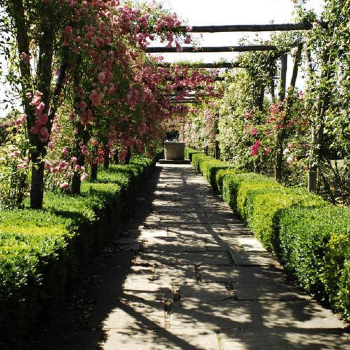
The West Lawn leads to a series of early C20 flower gardens which were laid out in the former early C19 kitchen gardens (C19 red-brick walls listed grade II). The walled gardens lie between 80m and 200m to the west of the house and include, from east to west, a Rose Garden, an Iris Garden, a Lavender Garden, and a Winter Garden, with ranges of bothies and glasshouses along the north side of the sequence. The east entrance to the Rose Garden is marked by a pair of stone griffins and from here a path leads west beneath a wooden pergola planted with rambling roses, to a C14 Italian well-head at the centre of the enclosure. From this point a cross-path leads north/south beneath further pergolas, dividing the garden into four rectangular beds, planted with roses, with borders of shrub roses, geraniums, and fuchsias, and edges of lavender and box. Set against the north wall are statues of the Four Seasons, while the wall itself supports roses, clematis, and wisteria. The Rose Garden is dominated by a water tower on the north side, which still (2000) supplies the garden with water. The main path through the Rose Garden continues westwards into a second walled garden, divided with yew hedges into three small gardens and bounded by C19 walls at the west and east ends and a C20 wall along the south side. The south wall is pierced with circular windows to allow views to and from the south and was added by Mrs Greville in 1912. The first garden has borders of peonies and lilies and to the west of this is an Iris Garden planted with old cultivars of Bearded Iris, with a statue on a tall sundial at its centre. To the west of the Iris Garden is the Lavender Garden with beds of Dutch and English lavender.
Beyond the west wall of the second walled garden is a Winter Garden, with trees underplanted with winter and early spring flowering bulbs and shrubs. From the Winter Garden a path leads southwards along the western boundary of the garden, then eastwards to a long herbaceous border which runs along the south wall of the walled gardens. To the south of the herbaceous border is a croquet lawn, with a statue in the south-east corner, and shrubs and some cedars of Lebanon planted in the 1960s around the edge. A bank divides the lawn from the Sunken Garden, an area planted with mature shrubs and trees, and with a rock garden at the west end. The Rock Garden is formed of Westmorland limestone and planted with dwarf shrubs and can also be approached from the steps down from the west end of the herbaceous border.
Several paths lead east through the Sunken Garden and onto the South Lawn, which lies to the south of the house. The lawn was the site of an early C20 fountain and flower garden commissioned by Captain Greville. A scheme put forward by the firm Murray and Seddon for an extensive Italian Garden in 1907 was only partially executed and was grassed over in the late C20. The lawn is bounded on the south side by an early C20 yew hedge and offers good views to the south over the park to Bagden Wood and Ranmore Common. The yew hedge continues to the east, forming the southern boundary of a c 500m long terrace known as the Long Walk, which was started in the 1760s and extended in c 1800 by Sheridan. The Walk runs from west to east and is retained by a limestone rubble wall (listed grade II), with the yew hedge standing above the ha-ha. The western end is marked by a pair of stone columns surmounted by lions and from here the Walk leads eastwards past seats and statuary, to a semicircular bay with equidistant rectangular bays, projecting to the south. There are views southwards along the length of the Walk over the park to Bagden Wood. It terminates at six tall Doric columns, part of the Doric portico of Joseph Bonsor's house, placed here in 1903 by Sir Clinton Dawkins. The Nun's Walk runs parallel to the Long Walk to the north, with late C20 planting of beech, yew, and holly which replaced the C18 and C19 trees which were felled in the 1970s. To the north of the eastern end of the Nun's Walk is an open-air theatre constructed in 1951 and to the north of the western end of the Nun's Walk is a Pinetum, with mature redwoods, cedars, spruce, and yew.
Admiral's Walk lies to the north of the east drive and runs parallel with the drive, Nun's Walk, and the Long Walk. The Walk is planted with mature trees and self-sown oaks and rhododendrons and runs along the south side of the car park and a picnic area in Preserve Copse.
PARK
The northern part of the park lies to the west and east of the main entrance drive from the north and consists of gently sloping ground with scattered trees and small clumps, including mature beech trees, with sweet and Spanish chestnuts.
There are large blocks of woodland on the east and south sides of the northern part of the park, including Connicut Wood to the east and Freehold Wood to the south-east, both mixed plantations with ash, oak, and beech, and Preserve Copse to the south, between the gardens and the park, planted with coniferous trees including Wellingtonias, redwoods, pines, cypress trees, and spruce. To the south-east of Preserve Copse is a former tree nursery for the estate, now (2000) planted with a mixture of pine, beech, oak, poplar, and Japanese maple. In the area of park to the east of the Nursery are several clumps of copper beech.
To the south of the garden is an area of park, backed by Bagden Wood and Ranmore Common. The sloping ground is planted with copses and small clumps of trees, some of which were derived from woodland or shaws which have been opened up in the C20. A C17 house, Tanner's Hatch (now a Youth Hostel; listed grade II), stands on the southern edge of the park. In the south-west corner of the southern part of the park (as here registered) is Prospect Lodge, a cottage built in 1854 by Sir Walter Farquhar, from where there are good views of the garden and house.
KITCHEN GARDEN
The early C20 kitchen gardens lie c 250m to the west of the house and are approached from the Winter Garden by an early C20 wooden bridge with a thatched roof which spans a cutting, excavated in 1861, for the road leading to Polesden Farm and Yew Tree Farm. The garden is now (2000) laid to grass, bounded by hedges and backed by woodland. In the late C20 it was planted with four squares of lime trees, with crossing avenues of common cherry. An early C20 thatched summerhouse terminates the west end of the east/west path. This garden was developed to replace the early C19 walled gardens of c 1.2ha when the latter were developed as ornamental gardens in the early C20 (see above).
REFERENCES
J P Neale, Views ... 1, (1824)
E W Brayley and J Britton, Topographical history of Surrey 4, (1841-8), p 471
W Keane, Beauties of Surrey (1849), pp 114-15
Country Life, 103 (5 March 1948), pp 478-81, 526; 169 (12 February 1981), pp 378-9
Proceedings of Leatherhead & District Local History Society 1, no 9 (1955), pp 25-9
M Allen, Fisons Guide (1970), p 60
N Pevsner et al, The Buildings of England: Surrey (1971), pp 414-15
Polesden Lacey, guidebook, (National Trust 1973)
T Wright, Gardens of Britain 4, (1978), pp 224-9
Polesden Lacey garden, guidebook, (National Trust 1992)
Polesden Lacey: Park and Garden Survey, (National Trust 1990/2)
Maps
John Rocque, Map of Surrey, surveyed around 1762, published 1768
Estate survey, 1797 (in National Trust 1990/2)
Estate survey, 1818 (in National Trust 1990/2)
Tithe map for Great Bookham parish, 1842 (in National Trust 1990/2)
OS 25" to 1 mile: 1st edition surveyed 1868-9; 2nd edition revised 1894-5, published 1896; 3rd edition revised 1912, published 1914
Description written: April 2000
Edited: April 2003
- Visitor Access, Directions & Contacts
Telephone
441372452048Access contact details
The gardens are open daily throughout the year from 11am to 4pm, except in January when the site is closed. http://www.nationaltrust.org.uk/place-pages/265/pages/opening-times-calendar
Directions
The site is off the A246 between Leatherhead and Guildford.
Owners
The National Trust
Heelis, Kemble Drive, Swindon, SN2 2NA
- History
The following is from the Register of Parks and Gardens of Special Historic Interest. For the most up-to-date Register entry, please visit the The National Heritage List for England (NHLE):
www.historicengland.org.uk/listing/the-list
HISTORIC DEVELOPMENT
There has been a house at Polesden Lacey since at least the 12th century but the first house whose appearance is known was built for the Rous family and completed by 1631. The estate was purchased by Arthur Moore, an economist and politician, in 1723 and his son, William, extended the house between 1735 and 1748. The Moores probably began the construction of the Long Walk or Terrace, which overlooks the park. The Sheridan family purchased the estate in 1797 and the house was in ruins by about 1814, when Richard Brinsley Sheridan, the playwright and politician, pulled most of it down with the intention of rebuilding it. However it was left to Joseph Bonsor, a stationer and bookseller, who purchased the estate in 1818, to rebuild the house to the designs of Thomas Cubitt. Bonsor was also responsible for planting thousands of trees, and renovating the garden, park, and estate. Sir Walter Farquhar purchased the estate in 1853 from the Bonsor family, and he enlarged the house between 1853 and 1870, preserving most of Cubitt's structure. Farquhar's house was in turn rebuilt in 1903-5 by Ambrose Poynter for Sir Clinton Dawkins, a civil servant and financier, who owned Polesden Lacey between 1902 and his death in 1906. Mrs Greville and her husband, Captain the Hon Ronald Greville, bought Polesden in 1906 and commissioned Mewes and Davis to alter the house. Ronald Greville died in 1909 but Mrs Greville continued to own Polesden Lacey until 1942, during which time she entertained Edward VII and other members of the royal family there. The Polesden Lacey Estate was bequeathed to the National Trust in 1942, and the house and garden were rearranged for public opening. The National Trust continue (2000) to own and manage the estate.
Period
- 18th Century (1701 to 1800)
- Late 18th Century (1767 to 1800)
- Associated People
- Features & Designations
Designations
The National Heritage List for England: Register of Parks and Gardens
- Reference: GD1233
- Grade: II*
Features
- Lawn
- Terrace
- Walk
- Description: The Long Walk.
- Rose Garden
- House (featured building)
- Description: There has been a house at Polesden Lacey since at least the 12th century. After several re-builds and alterations, the house was rebuilt in 1903-5 by Ambrose Poynter for Sir Clinton Dawkins.
- Earliest Date:
- Latest Date:
- Gardens
- Key Information
Type
Estate
Purpose
Ornamental
Principal Building
Domestic / Residential
Period
18th Century (1701 to 1800)
Survival
Extant
Hectares
126
Open to the public
Yes
Electoral Ward
Bookham South
- References
References
- {English Heritage Register of Parks and Gardens of Special Historic Interest}, (Swindon: English Heritage, 2008) [on CD-ROM] Historic England Register of Parks and Gardens of Special Historic Interest
- Wright, T., {The Gardens of Britain 4: Kent, East & West Sussex and Surrey} (London: Batsford, 1978), pp. 224-9 The Gardens of Britain 4: Kent, East & West Sussex and Surrey
- Keane, W., {The Beauties of Surrey} (London: [n.pub], 1849), pp. 114-5 The Beauties of Surrey: being a description of about one hundred and twenty seats of the nobility and gentry in the county of Surrey etc.
- Pevsner, N. et al., {The Buildings of England: Surrey} (New Haven, Connecticut and London: Yale University Press, 1971), pp. 414-5 The Buildings of England: Surrey
- Rutherford, Sarah {Polesden Lacey Estate Surrey Garden Conservation Plan (2 vols)} (2011) Polesden Lacey Estate Surrey Garden Conservation Plan (2 vols)
- ACTA {Polesden Lacey Estate Surrey Conservation Management Plan (3 vols)} (2013) Polesden Lacey Estate Surrey Conservation Management Plan (3 vols)
- Hardwick, Sallyann {Polesden Lacey Garden Conservation Plan} (1998) Polesden Lacey Garden Conservation Plan
- ACTA {Polesden Lacey. Park Conservation Management Plan} (2011) Polesden Lacey. Park Conservation Management Plan
- Related Documents