Introduction
Clandon has gardens and pleasure grounds of around 9 hectares, set within a landscaped park which originally covered some 220 hectares. The National Trust were gifted 7 acres, along with Clandon House in 1956. A further 2 acres were added to their care later so thy might extend their car park. The remainder of Clandon Park and its associated farmland and commercial forestry (approx. 1000 acres) has remained in the ownership of the Onslow family since the 1600s.
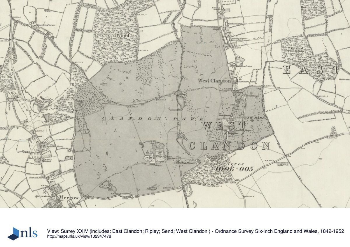
Terrain
The ground slopes generally down from the south-east and west towards the north-east.
The following is from the Register of Parks and Gardens of Special Historic Interest. For the most up-to-date Register entry, please visit the The National Heritage List for England (NHLE):
www.historicengland.org.uk/lis...
DESCRIPTION
LOCATION, AREA, BOUNDARIES, LANDFORM, SETTING
Clandon House and its surrounding parkland, c 220ha, are located immediately west of West Clandon, in the county of Surrey. The park is bounded by Epsom Road (A25) to the south, the London to Guildford railway line to the north, the A247 and houses and gardens in the village of West Clandon to the east, Park Lane to the south-west, and Merrow Common to the north-west. The ground slopes generally down from the south-east and west towards the north-east. There are good views from the higher ground, especially the lawns to the east of the House, northwards over the park. The boundaries of the park are marked by a mixture of walls and fences.
ENTRANCES AND APPROACHES
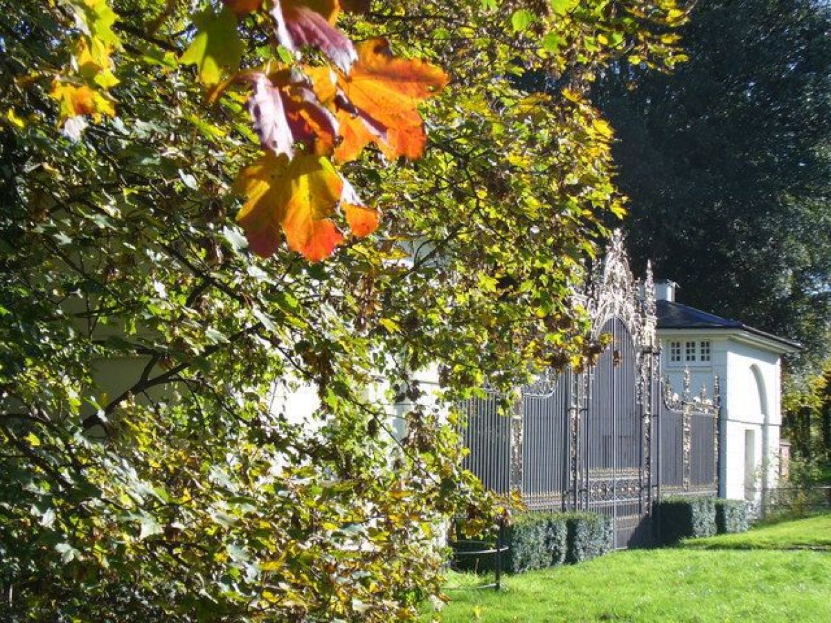
The main entrance in the late C18 was from the south-west corner of the park, approached from Merrow. Two lodges here, by Lancelot Brown (1776), flank early C18 wrought-iron gates with overthrow (listed grade II* with the lodges), set up in this position by Brown. The drive leads through a lime avenue (planted between 1897 and 1920, with C20 replanting) north-east to Temple Court and then east to Clandon House but the entrance is no longer used (2000). A second C18 approach leads from the south through Henchley Gate off the A25, from where a drive runs north to join the drive from the Merrow Lodges.
The main (public) access for Clandon House is from the east, c 120m north of the church of St Peter and St Paul. This curves south-west for 100m to a car park, c 150m north-east of the House. The drive continues west past the car park, c 20m north of the House, to Temple Court, or south around the south front of the House to a large gravelled forecourt before the west or entrance front. This access drive was formed by the National Trust in the 1970s. A drive leads west from an entrance c 50m further to the north of the National Trust entrance, and after c 200m divides into three branches: a late C19 drive leads west to the north side of Temple Court; an C18 drive leads south, along the west side of the car park and then connects to the main drive; and an early C19 drive leads north up the east side of the park and then curves north-east to an entrance through Cranley Lodge onto the A247, c 900m north of the church.
PRINCIPAL BUILDING
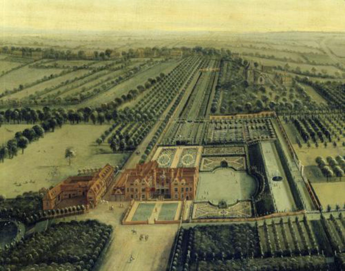
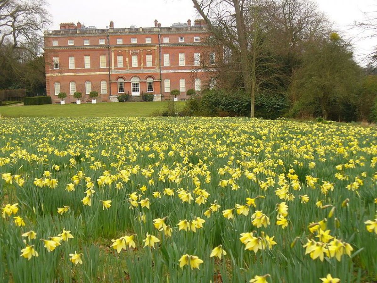
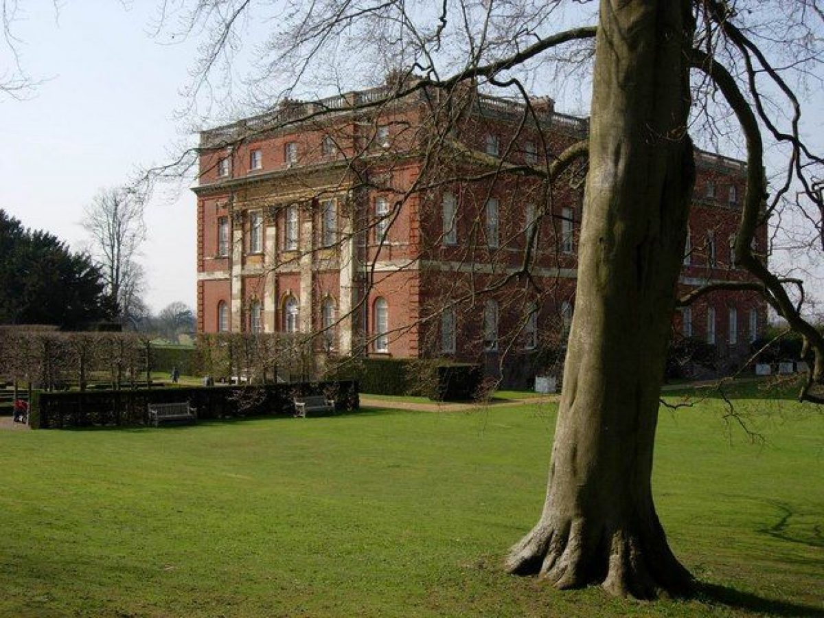
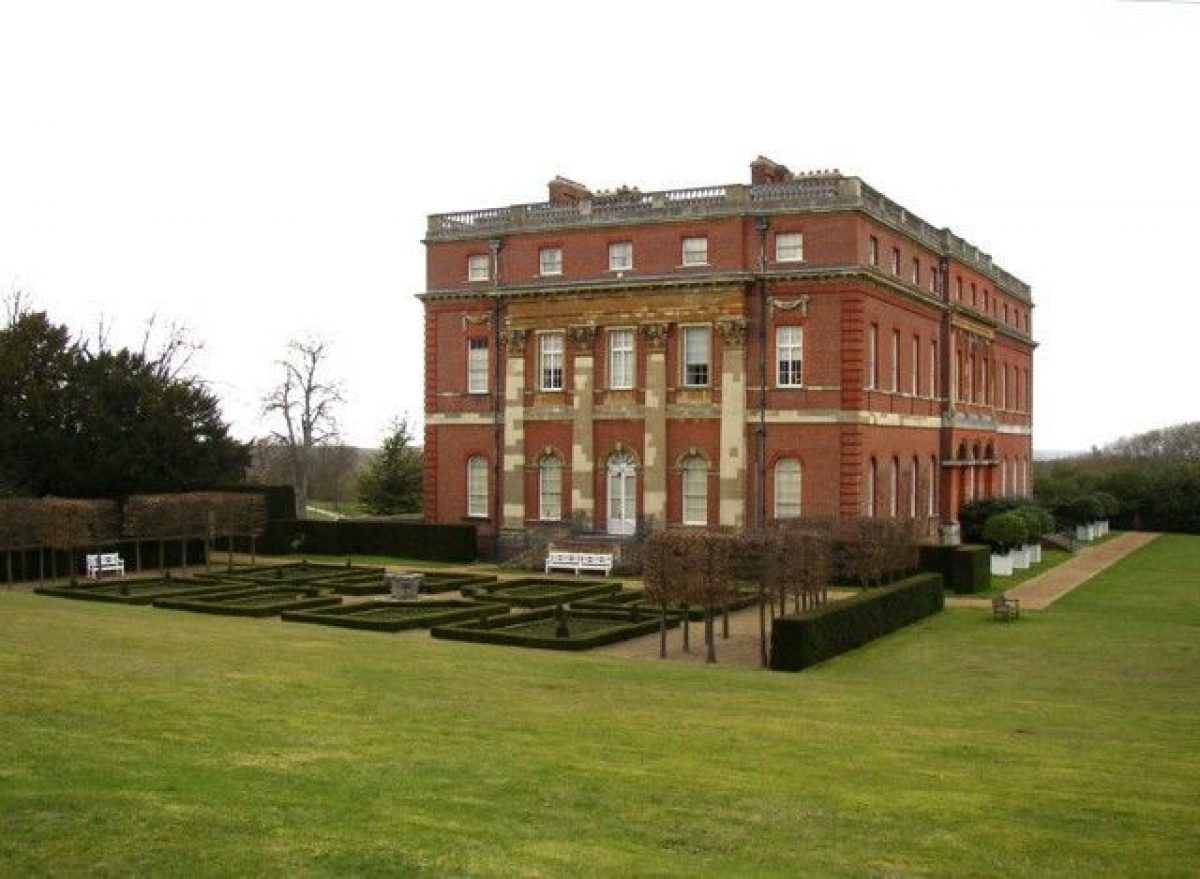
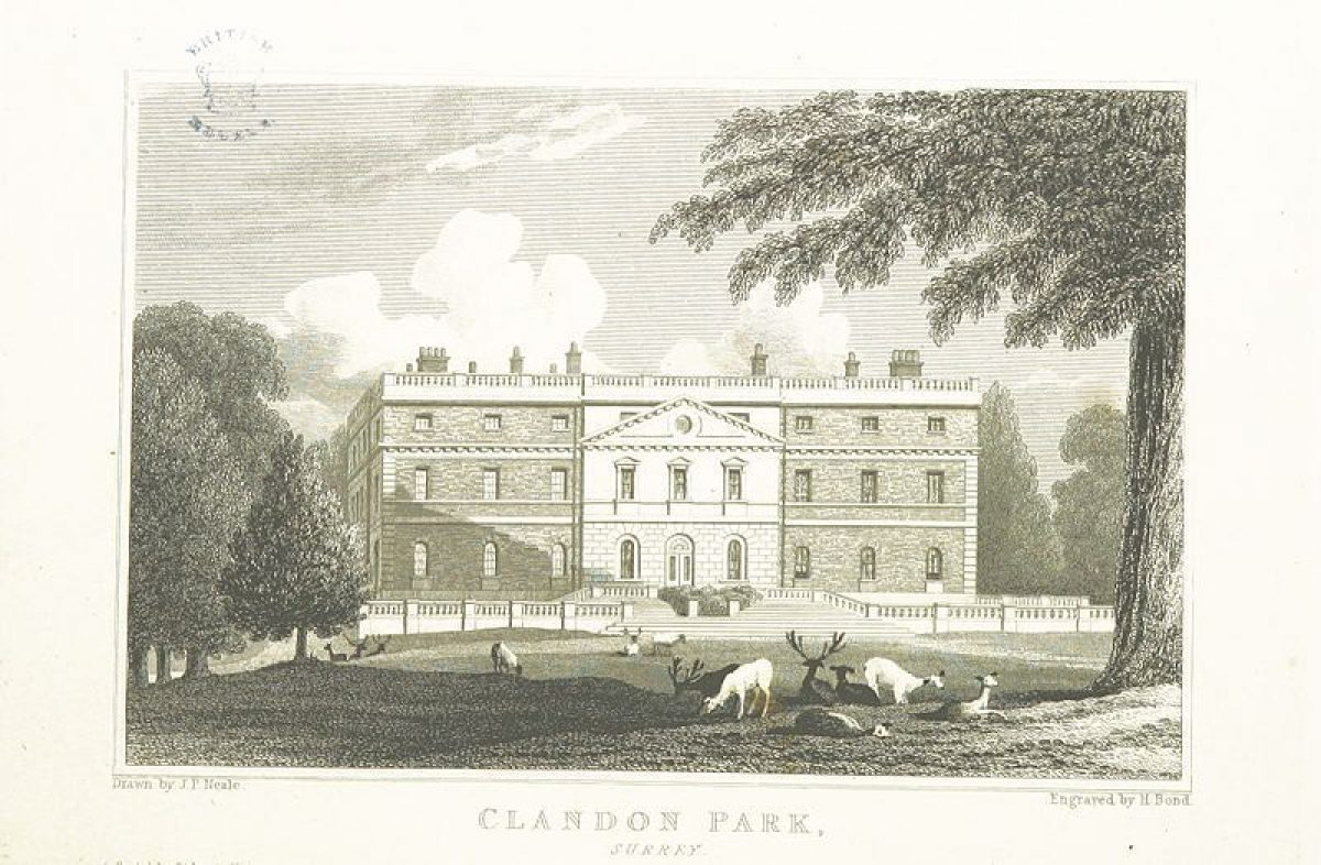
Clandon House (listed grade I) stands in the south-east corner of the park, with gardens to the south and east. It was designed in c 1713 by Giacomo Leoni for Thomas Onslow but not built until 1725-31. A porch and porte-cochere were added to entrance (west) front in 1876 by the fourth Earl of Onslow. The House is built on a square plan, with the porch projecting to the west and four different elevations. It is in red brick with stone dressings, the roof obscured by parapets. The interior includes a fine, two-storey marble hall.
A group of buildings stands south of the centre of the park, c 500m west-north-west of Clandon House and immediately west of the kitchen garden. The group includes a house known as Temple Court, probably C17 and altered in the C18 and later. An early C18 barn, now a stable (listed grade II), stands c 25m to the north of Temple Court. It is timber framed, on a brick plinth with weatherboard cladding. An C18 dovecot (listed grade II) stands c 15m to the south of Temple Court. It is built in flint rubble, with a brick-edged plinth and angle quoins, and a pyramidal tiled roof with deep eaves.
A block of stables, built c 1776 by Brown in a late Palladian style (demolished c 1972), stood to the west of the House near to Temple Court.
The C13 church of St Peter and St Paul stands c 200m to the east of Clandon House (adjacent and just outside the area here registered). The north tower with its wooden spire was added in 1879, the wooden spire being rebuilt in 1913.
GARDENS AND PLEASURE GROUNDS
Clandon House is set on lawns of c 1776?81 to the south and east, bordered by gardens mainly laid out in the late C19 but with some surviving late C18 tree and shrub planting. Gravel paths, laid out in the late C19, border the House on the south and east sides. To the south of the House is a parterre which lies between the gravel path and a sloping lawn. The parterre consists of eight rectangular enclosures, with box hedges around the edge and bedding plants in the centre. The four outer enclosures have box cones in the corners and the four inner ones curve around a stone capital. The parterre was laid out in 1978, to the design of John Fowler and Paul Miles for the National Trust. It is enclosed by two palisades of hornbeams planted in 1976. The parterre replaced an earlier C20 scheme with rectangular flower beds. From the parterre, which is on level ground, the ground slopes up to a Grotto and Bathhouse (listed grade II), c 60m south of the House, backed by an extensive shrubbery. The Grotto was designed by Lancelot Brown 1776-81, and is formed of flint rubble. It has a pedimented central range with an elliptical arch with rustic voussoirs, flanked by lower, curved retaining walls to the west and east. The interior has brick dressings and patterning, with a vaulted roof with six arched niches to the walls. A statuary group of the Three Graces stands just inside the Grotto and a sunken stone bath stands in the centre of the rear.
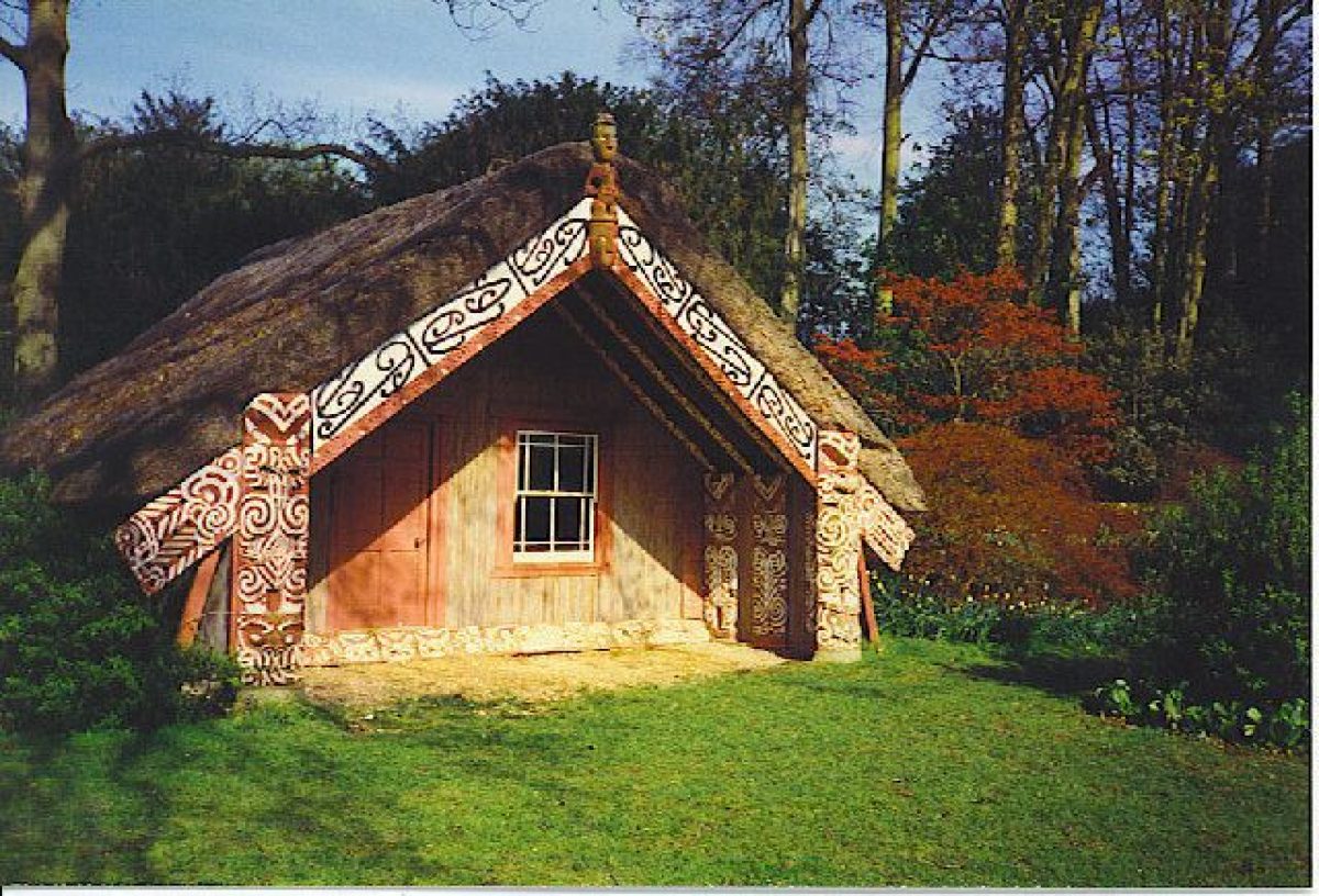
The lawn to the east of the House is backed by shrubberies, clearings giving views through to the church and further areas of the garden. A Maori Meeting House (listed grade II) stands on the east side of the lawn, c 70m to the east of the House. It is aligned on the gravel path which runs along the south side of Clandon House, which in the late C19 continued up to the Maori House lined by herbaceous borders. Brought from New Zealand by Lord Onslow in c 1892, the Maori House is timber framed with a gabled roof which is thatched with bamboo and reeds. The walls are clad and painted in bright colours. The building was shortened and moved to this site between 1920 and 1934 from its original position in the park on the shore of the Millpond.
A ha-ha runs along the east side of the main part of the garden and a further area of garden to the north of the church and east of the ha-ha is now (2000) approached from the entrance drive. A sunken Dutch Garden lies in the north-east corner of this garden, c 220m east-north-east of the House. It was laid out between 1897 and 1902, based on the sunken garden at Hampton Court (qv), and was restored by the National Trust in the late C20 to a simplified design. It has a central round pool, with clipped hedges, topiary, and statuary. The approach to the Dutch Garden was originally along a double row of Lawson's cypress which ran from west to east, with Corinthian capitals (probably from Clandon Regis) set within the rows of trees. The capitals were moved to this location between 1910 and 1925 from their late C19/early C20 location along the lines of the trees. The last remaining cypress trees fell in the 1987 storm and only the brick bases for the capitals remain.
An C18 Wilderness of c 6ha lies to the south of the garden, in the south-east corner of the park. It has glades amongst the trees, with some remaining C19 ornamental planting including yews and bulbs. An C18 perimeter walk runs along the south side, with box, philadelphus, holm oak, laburnum, and Iris foetidissima along its length. Within the Wilderness is a grass tennis court laid out by William Hillier Onslow, surrounded by an overgrown yew hedge. Most of the paths were cut through in the late C19 on the advice of Nesfield and were probably on the lines of the C18 walks (National Trust 1990).
PARK
The remains of a double beech avenue, Cranley Avenue, lies to the west of the House. This was planted in 1877, with copper beech on the inner rows and green beech on the outer rows. It is on the approximate line of the early C18 avenue (Senex, 1729; Rocque, 1768), which was removed by Brown in the 1780s. The avenue suffered from storm damage in 1987 and few of the trees in the east section have survived.
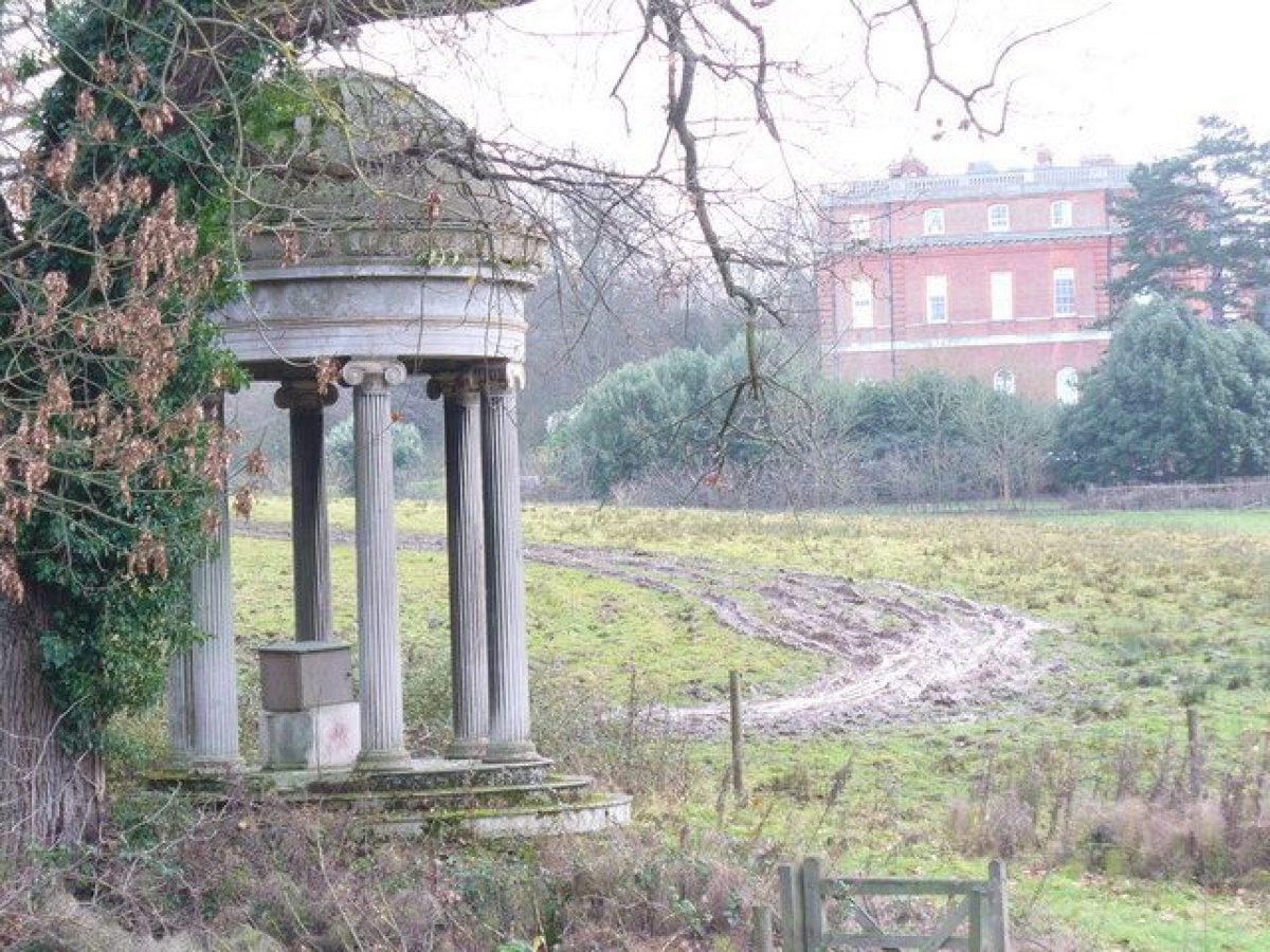
There are three main bodies of water in the park. The South Pool is leg of mutton-shaped and lies 100?300m to the north-west of the House. This was formed by Brown in the late C18 from an early C18 canal. An Iris Garden was laid out along the eastern shore in the late C19 which consisted of a path through swathes of naturalised daffodils and irises, with bamboo. This garden was abandoned before the Second World War but traces of the ornamental planting around the pool remain, including Taxodium distichum specimens and robinia in the woodland on the west side, ornamental planting of bamboo, aucuba, rhododendron, gunnera, and pear amongst the scrub at the southern end of the pool, and lilac, cedar of Lebanon, Monterey pine, and holm oak in the wood to the north of the pool. A circular stone temple with a copper dome supported by six Ionic columns (W and H W Inwood 1838, listed grade II) stands c 200m to the north-north-west of the House on the north-east edge of the South Pool. It was moved to this location in 1924 from Clandon Regis. The temple is backed by woodland on the east side of the South Pool, planted after 1897 with ash and hazel coppice. A late C19 boathouse and an ornamental bridge across the lake no longer exist.
A smaller lake lies c 250m to the north of the South Pool. It is bordered by trees and was formed by Brown in the late C18 from an existing millpond. In the late C19 the Maori House was sited next to this lake, and was surrounded by planting (iris, gunnera, climbing roses, and spiraea). The garden was abandoned and the Maori House moved to its present position by 1934. The Millpond and the South Pool were connected in the late C19 by a canal which no longer exists. A large fishing pool was formed in the park in c 1980 and lies c 200m north of the Millpond.
The park, which was divided into fields in the late C19, is now managed as farmland (some fields grazed and other parts cultivated), with C20 plantations. The C18 and C19 boundary plantations to the north, east, and south-east and some C18 and C19 parkland trees survive.
KITCHEN GARDEN
The walled kitchen garden, c 1.1ha, lies immediately to the east of Temple Court, c 350m to the west-north-west of the House. The interior has been used as a garden centre since c 1980 and none of the former glasshouses, planting or path system has survived.
REFERENCES
W Keane, Beauties of Surrey (1849), pp 119-20
Gardeners' Chronicle, ii (1885), pp 711-12; ii (1910), pp 112-16, 123, 394
Gardener's Magazine, (1911), pp 341
Country Life, 62 (10 September 1927), pp 366-72; (24 September 1927), pp 434-40; 146 (4 December 1969), pp 1456-60; (11 December 1969), pp 1582-4 Country Life Annual (1968), p 87
N Pevsner et al, The Buildings of England: Surrey (1971), pp 507
B Jones, Follies & Grottoes (1974), p 397
D Stroud, Capability Brown (1975), p 220
J Harris, The Artist and the Country House (1979), p 118
G S Thomas, The Gardens of the National Trust (1979), pp 115-16
Clandon: Park and Garden Survey, (National Trust 1990)
Maps
J Senex, Map of Surrey, 1729
Map of the parish of Clandon, c 1733 (reproduced in NT 1990)
J Rocque, Map of Surrey, surveyed c 1762, published 1768
J Willock, Estate map, 1776 (reproduced in NT 1990)
C and J Greenwood, Map of Surrey, 1823
OS Old Series 1" to 1 mile, published 1811
OS 6" to 1 mile: 1st edition surveyed 1870, published 1873
OS 25" to 1 mile:
1st edition surveyed 1870, published 1871
2nd edition revised 1895, published 1896
Description written: March 2000
Register Inspector: CB
Edited: April 2003
- Visitor Access, Directions & Contacts
Telephone
441483222482Access contact details
The gardens are open between March and October from 11 until 5, with the exception of Mondays, Fridays and Saturdays.
Directions
The site is 3 miles east of Guildford, at West Clandon on the A247. There is a railway station at Clandon 1 mile away.
Owners
The National Trust
Heelis, Kemble Drive, Swindon, SN2 2NAThe Onslow family
Other Websites
- http://www.nationaltrust.org.uk/clandon-park/
- http://list.historicengland.org.uk/resultsingle.aspx?uid=1001171
- https://www.parksandgardens.org/research-and-record/300-documents-for-the-database/904-clandon-park-geophysical-survey
- http://research.historicengland.org.uk/Report.aspx?i=15395&ru=%2fResults.aspx%3fp%3d1%26n%3d10%26rn%3d83%26ry%3d2015%26ns%3d1
- https://clandonpark.com
- History
The following is from the Register of Parks and Gardens of Special Historic Interest. For the most up-to-date Register entry, please visit the The National Heritage List for England (NHLE):
www.historicengland.org.uk/lis...
HISTORIC DEVELOPMENT
In 1531, Sir Richard Weston was granted a license to impark an area of 1050 acres (c 425ha) in Merrow and Clandon; this was later disparked. In 1642, Sir Richard Onslow bought a lodge in what had been the park and reimparked. By the early C18 a large formal landscape had been laid out, which is depicted in a view of Clandon by Knyff of 1708 (in National Trust 1990). To the west of the house was a deer park of c 80 acres (c 32ha), located in the south-east corner of the present park, and agricultural land was shown to the north. The main entrance was by a brick-walled forecourt on the west front with a double avenue aligned on it to the west. A stable block stood to the north of the house. The formal garden included a canal, parterres, and a Wilderness, covering and extending beyond the present garden. The house was rebuilt on the site of the old house between 1720 and 1730 by Leoni for Thomas Onslow, but the formal garden, canal, Wilderness, and small park were retained. A map of the parish of Clandon of c 1733 shows a layout similar to that shown by Knyff.
Thomas, second Baron Onslow died in 1740, and was succeeded by his son Richard, third Baron Onslow. The main road was turnpiked and straightened in 1758, possibly adding a small area to the south-east corner of the park. Rocque's survey of Surrey (1768) depicts the landscape, which was still formal at this date.
Richard, third Baron Onslow died in 1776 and was succeeded by his nephew George, fourth Baron Onslow, who commissioned John Willock to carry out a detailed survey of the estate in 1776. Lancelot Brown (1716-83) was commissioned to landscape the gardens and park in 1776 (plan dated 1781 referred to in CL 1927, now missing) and he removed the remaining formal gardens, altered the canal into an informal lake (the South Pool), and greatly extended the park to the west and north (National Trust 1990). An existing millpond (shown on Rocque, 1768; Willock, 1776) was increased in size to form another lake. Brown also built two lodges and moved a pair of fine wrought-iron gates from their former position close to the house, to their present location in the south-west corner of the park; this became the main entrance. New stables were built but the earlier stables by the house were retained.
In 1780 small parcels of land were sold to pay off debts but improvements were continued by the fourth Baron (created Earl of Onslow) into the early years of the C19. George, the first Earl, died in 1814 and was succeeded by his son Tom, second Earl of Onslow. He demolished the old stables to the north of the house in 1814. The second Earl died in 1827 and was succeeded by his son Arthur George, third Earl. He abandoned Clandon and lived at nearby Clandon Regis and later in Richmond. The house and garden were neglected during this period (1827-70).
In 1870 the third Earl died and was succeeded by his son, William Hillier, fourth Earl of Onslow. William Hillier restored the house, adding the porte-cochre to the west front. Nesfield (William Andrew or his son Markham) was consulted about the garden layout and work was carried out in the garden and Wilderness (National Trust 1990). The park was further extended to the north-east and restocked with deer, new plantations were planted, and a double beech avenue was planted to the west of the house (on the line of the C18 avenue). The park was then subdivided and much of it was used for grazing. Between 1895 and 1910 the garden was developed from 'a lawn of six acres' (Gardeners' Chronicle 1885) to a series of gardens, famous by the early C20. Further gardens were developed along the banks of the South Pool and Millpond in the park.
The northern end of the park was sold off for the new railway in the late C19 and during the C20 trees were lost due to decay, Dutch elm disease, and the storms of 1987 and 1990. The easternmost part of the park was developed for housing in West Clandon in the C20.
Clandon House was used as a hospital in the First World War and as a depository for the Public Record Office during the Second World War. The House and garden were given to the National Trust in 1956 in whose ownership they remain (2000). The park continues in private ownership.
Period
- 18th Century (1701 to 1800)
- Late 18th Century (1767 to 1800)
- Associated People
- Features & Designations
Designations
The National Heritage List for England: Register of Parks and Gardens
- Reference: GD2176
- Grade: II
Features
- Parterre
- Grotto
- Planting
- Description: Sunken Dutch garden.
- House (featured building)
- Description: The house was rebuilt on the site of the old house between 1720 and 1730 by Leoni for Thomas Onslow.
- Earliest Date:
- Latest Date:
- Garden Building
- Description: Maori meeting house.
- Earliest Date:
- Latest Date:
- Key Information
Type
Park
Purpose
Ornamental
Principal Building
Domestic / Residential
Period
18th Century (1701 to 1800)
Survival
Extant
Open to the public
Yes
Civil Parish
West Clandon
- References
References
- {English Heritage Register of Parks and Gardens of Special Historic Interest}, (Swindon: English Heritage, 2008) [on CD-ROM] Historic England Register of Parks and Gardens of Special Historic Interest
- Stroud, Dorothy, {Capability Brown} (London: Faber, 1975), p. 220 Capability Brown
- Harris, J., {The Artist and the Country House} {London: Russell Chambers, 1979), p. 118 The Artist and the Country House
- Thomas, G. S., {Gardens of the National Trust} ([London]: Weidenfeld and Nicolson, 1979), pp. 115-6 Gardens of the National Trust (1979)
- Keane, W., {The Beauties of Surrey} (London: [n.pub], 1849), pp. 119-20 The Beauties of Surrey: being a description of about one hundred and twenty seats of the nobility and gentry in the county of Surrey etc.
- Pevsner, N. et al., {The Buildings of England: Surrey} (New Haven, Connecticut and London: Yale University Press, 1971), p. 507 The Buildings of England: Surrey
- Nicholas Pearson Associates {Clandon Conservation Statement} (2010) Clandon Conservation Statement
- Fretwell, Katie {Clandon: park and garden survey} (1990) Clandon: park and garden survey