Introduction
Hatch Court has gardens, landscaped pleasure grounds and a park amounting to some 60 hectares, dating predominantly from the mid-18th century. Hatch Court occupies a ridge of high ground from which the land drops away steeply, giving extensive views in all directions which are framed by planting in the pleasure grounds and park.
Terrain
Ridge of high ground.
The following is from the Register of Parks and Gardens of Special Historic Interest. For the most up-to-date Register entry, please visit The National Heritage List for England (NHLE):
Extensive mid-18th-century pleasure grounds and a park with associated landscape structures.
Location, Area, Boundaries, Landform and Setting
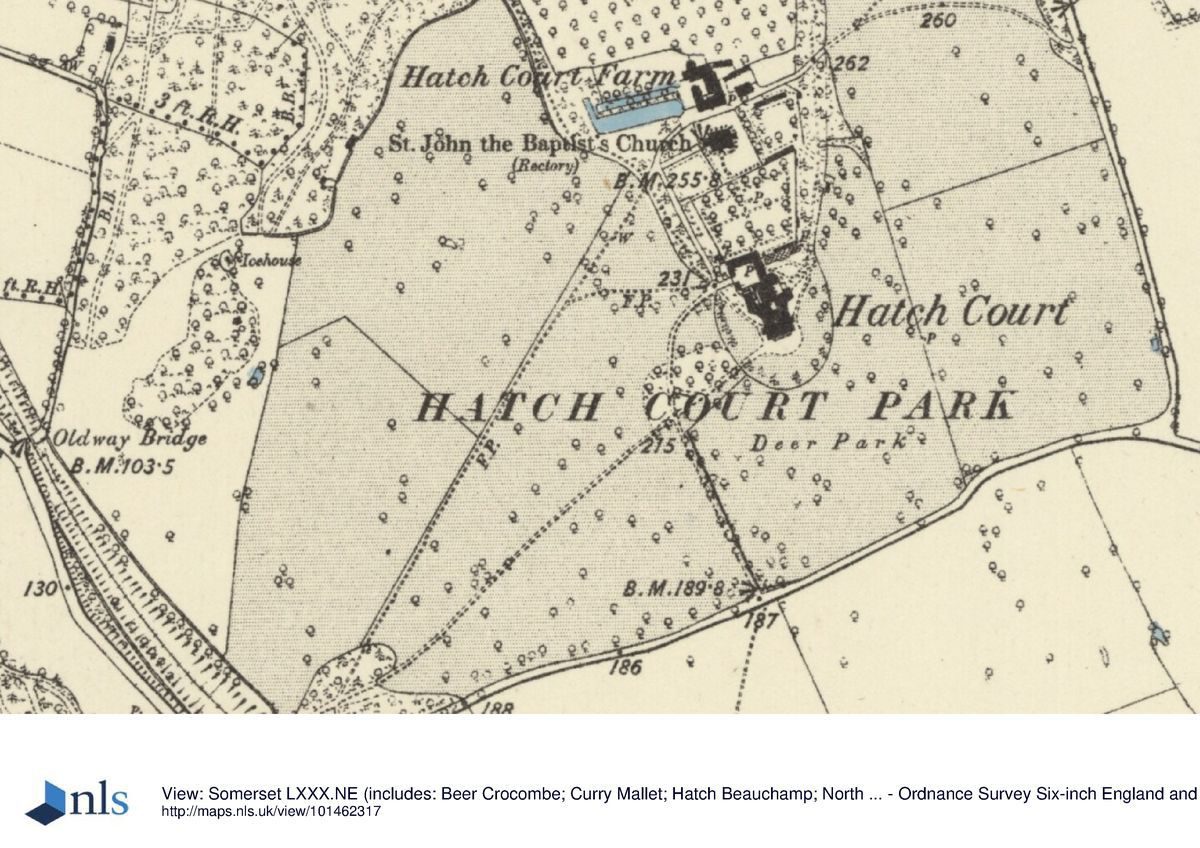
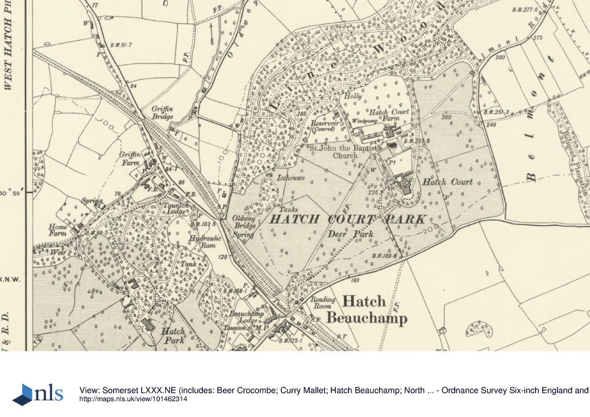
Hatch Court is situated c 6km south-east of Taunton and c 0.5km north-east of the village of Hatch Beauchamp, to the east of the A358 road. The c 60ha site comprises some 30ha of gardens and pleasure grounds, and c 30ha of parkland. To the north the site adjoins agricultural land and to the west the boundary is formed by a minor road, Oldway Lane. To the south-west the boundary is formed by the late C19 cutting of the former Taunton to Chard branch railway which is today (2000) disused. The railway passes through a tunnel at the southern corner of the site, beneath the principal drive. The south boundary of the site is formed by a minor road, from which it is separated by hedges. A further minor road, Belmont Road, forms the eastern boundary of the site, separating it from adjacent agricultural land and orchards. Traces of shrubbery walks and viewing mounds, elements of a mid C18 pleasure-ground walk associated with Belmont, survive within this area (John Townson pers comm, 2000). To the north-east the site adjoins agricultural land and woodland on Crimson Hill. Hatch Court occupies a ridge of high ground from which the land drops away steeply to the north through Line Wood, and more gently to the east, west, and south.
There are extensive views in all directions which are framed by planting in the pleasure grounds and park, with a series of designed views west, north, north-east, and south-east from the pleasure ground walks and the sites of various landscape structures to the north of the house. A reciprocal designed view extends north-west across the Vale of Taunton from the site of the Chapel and Bastion c 730m north-east of the house to the Gothic Alcove at Hestercombe (qv), c 8.5km distant. There are further views north-east from Belmont towards the column erected by Lancelot Brown for William Pitt at Burton Pynsent (qv) in 1765, and south and south-west from the house across the park and adjacent agricultural land.
Entrances and Approaches
Hatch Court is approached from the minor road, formerly the A358, which passes through the village of Hatch Beauchamp at the southern corner of the site. The entrance is marked by a pair of monumental, square-section piers constructed in rusticated and vermiculated stone, which are surmounted by low pyramid caps. A pair of lodges and entrance gates designed by Sir Edwin Lutyens (1869-1944) in 1926 was not executed (Plans, private collection; John Townson pers comm, 2000). The tarmac drive extends c 160m north and north-east from the entrance, passing through an area of evergreen shrubbery and mature trees to enter the park through a C19 wrought-iron gate; contemporary metal estate fencing separates the shrubbery adjoining the drive from the park. A footpath crosses the drive c 100m north-east of the entrance; leading south-south-east, this footpath emerges onto the minor road forming the southern boundary of the site adjacent to a mid C19 former Methodist chapel, and opposite a mid C19 ornamental stone wall or screen in which is set a blocked gothic arch.
The principal drive extends north-east across the park for c 320m before crossing the secondary, south drive; it then extends a further c 50m north-east from this junction. Passing through a late C20 avenue of pleached limes, it enters the pleasure grounds south-west of the house through C19 wrought-iron gates and continues c 20m to reach a semicircular gravelled carriage turn below the south façade of the house.
The south drive enters the park from the minor road forming the southern boundary of the site and passes c 160m north-north-west through a late C20 avenue of horse chestnuts before crossing the principal drive and sweeping c 100m north-east to reach the early C19 stables (listed grade II) immediately north of the house. The stables were constructed for Henry Powell Collins by an unknown architect c 1820, and replaced mid C18 stables to the west of the house which were probably designed by Thomas Prowse; the C18 stables are shown in an engraving by Bonnor published in Collinson's History of Somerset (1971). Beyond the stables the south drive continues north, parallel to the west wall of the kitchen garden to reach a gravelled parking area west of the parish church of St John the Baptist (listed grade I). From this point the drive sweeps north-east to reach the home farm, Hatch Court Farm, c 130m north of the house.
Principal Building
Hatch Court (listed grade I) stands on a level terrace towards the centre of the site, with views east, south, and west across the park and adjacent agricultural land. The house is constructed in Bath stone ashlar and comprises a central two-storey block which is approximately square on plan, with four, three-storey corner towers surmounted by pyramid roofs. The slate roofs and attic windows of the main block are concealed behind balustraded parapets, while a string course articulates the division between the ground and first floor. The south or entrance façade has a ground-floor loggia comprising five linked round-headed arches; this is approached from the carriage turn by a wide flight of stone-flagged steps. The loggia contains a pair of round-headed niches which, until the early C20, contained a pair of male and female lead figures (photographs). The east and west facades are of identical design, with a central canted bay window rising to the full height of the building. A double flight of stone steps with cast-iron hand rails descends from windows surmounted be segmental pediments in each bay. Single-storey early C19 stuccoed quadrant wings extend north-west and north-east from the main block. The wing to the north-west contains an orangery lit by full-height segmental-headed windows, while that to the north-east is of similar design and contains service quarters. Further early C19 service quarters lie to the north of the house and to the south of the contemporary stables (listed grade II). The interior of the house and the south loggia retain significant mid C18 rococo plasterwork.
Hatch Court was built to designs by the amateur architect Thomas Prowse for John Collins in 1755. Prowse, who served as MP for Somerset for twenty-seven years, was a member of a group of amateur designers and dilettante which included Sanderson Miller (1716-80), Lord Lyttelton (1709-73) of Hagley Hall, Worcestershire (qv), and the sixth Earl of Coventry of Croome Court, Worcestershire (qv). Prowse was consulted on the design of these houses, and also designed the Temple of Harmony for Sir Charles Kemeys Tynte at Haiswell Park, Somerset (qv) c 1765. The mid C18 Palladian mansion replaced an earlier house which stood c 100m north-west, to the west of the parish church. This building was said to be ruinous in 1633 (guidebook).
Gardens and Pleasure Grounds
Formal and informal gardens and pleasure grounds lie to the east, south, and west of the house, with a further area of informal pleasure grounds and woodland walks to the north. The pleasure grounds around the house are separated from the park to the east, south, and west by C19 metal estate fencing with ornamental down-swept top rails. The area enclosed forms a semi-ellipse on plan, projecting into the deer park to the south.
To the south of the house and the carriage turn, a lawn is planted with mature specimen trees. A grass bank descends to a level semicircular lawn which is planted with a pair of symmetrically placed mature Irish yews. A mid C20 rectangular swimming pool with apsidal ends to the east and west is placed centrally on the lawn below the house. The corners of the pool are marked by late C20 yews, while a late C20 vase and fountain stand at the centre of the pool. Mid C20 photographs (CL 1964) show a more complex formal garden on the south lawn with rose beds and stone steps aligned on the central axis of the house. The formal garden appears to date from the mid C19, and replaced the lawns planted with specimen trees shown in Bonnor's engraving of c 1785. Mid C18 drawings attributed to Thomas Prowse (private collection) show a lawn to the south of the house separated from the park by a straight ha-ha extending from west to east and returning to the east of the house; it is unclear whether this scheme was implemented (John Townson pers comm, 2000).
A gravel walk extends from the carriage turn below the west façade of the house, past the orangery to reach the stables to the north-west. A late C20 geometrical box-edged parterre is planted within the recess formed by the north-west quadrant wing containing the orangery; this replaces a mid C20 rose garden (guidebook). There are groups of ornamental shrubs to the north-west screening the entrance to the stables. A similar gravel walk extends to the east of the house, while the south lawn returns below the east façade. A grass bank on an axis with the east end of the north-east quadrant wing is surmounted by a late C20 yew hedge. This hedge separates the lower lawn from a further lawn to the north-east of the house which is planted with mature cedars. A stone bench seat stands in a recess in the south side of the yew hedge overlooking the lower lawn. The upper lawn is enclosed to east and west by herbaceous borders, while to the north further herbaceous borders flank the site of an early C19 conservatory which stood against the outer face of the south wall of the kitchen garden; this is today (2000) planted with roses. To the west of the site of the conservatory, an ornamental wrought-iron gate leads through the wall to the kitchen garden, while to the east of the conservatory a grass walk planted with specimen trees, shrubs and conifers extends below the east wall of the kitchen garden. Late C20 developments in the gardens including the parterre and herbaceous borders were designed by Robin Odgers and Lucy Huntingdon.
The east walk formerly connected with a shrubbery walk c 190m north-east of the house; the walk is today blocked-off. Planted with laurel and box beneath specimen trees including mature Turkey oaks, the east walk leads to the woodland pleasure grounds c 350m north of the house. The east walk is not shown on a deed plan of 1820, but appears to have been established at about that date. A similar walk extends from the drive to the west of the parish church, each walk enclosing an undulating paddock to the north of Hatch Court Farm and affording views across both the paddock and the surrounding park and country. In 1820 the paddock was planted as an orchard (Deed plan, 1820) and continued in this use in the late C19 (OS).
The west walk passes to the south and west of a U-shaped pond with a narrow northern branch separated from the main body of the pond by a narrow isthmus of land planted with trees. This pond was formerly two pools, an L-shaped pool to the south and a narrow rectangular pool to the north; it assumed its present form in the C20. The pond may be related to the medieval manor house which probably stood on a site to the south (John Townson pers comm, 2000). The west walk extends c 130m north-west. A junction with walks leading west and east along the summit of a north-facing wooded escarpment. A bank visible at several points to the north of the walk represents both the parish boundary between Hatch Beauchamp and North Curry, and the extent of John Collins' property in the mid C18; the woodlands on the lower slopes were acquired by Henry Collins c 1820. To the west and south-west the walk leads c 160m to the remains of a late C18 or early C19 brick-lined icehouse; this structure was filled in c 1900. Some 80m south-west of the icehouse the remains of a substantial mid C18 grotto are set into the north-west-facing slope below the walk. The grotto comprises the remains of a central approximately circular chamber constructed in rustic stone with the possible remains of a chimney flue to the south-east and an entrance to the west. A single dressed stone roof rib survives, while the remainder of the roof has collapsed into the interior of the structure. To the south-west a curved wall extends to a feature which may have been a pool or further chamber. Traces of a further stone structure, possibly a tunnel or wall, are visible to the north of the main chamber. To the east, and at a higher level, archaeological investigation has revealed a square stone-lined catch pit which supplied water via a lead pipe to the grotto (Webster 1998). The grotto is traditionally known as 'Diana's Baths' and is said to have comprised two chambers linked by a tunnel, one chamber possibly containing a plunge pool and the other waterworks (Townson 1999). The grotto was constructed for John Collins to the design of an unknown architect and was described by Edward Knight in 1761 (Diary, 1876).
The principal walk continues to the south and above the grotto, leading to an eminence from which there are extensive views west and north-west. To the south-east of the walk a depression below the park to the south-east has been identified as a possible site for the mid C18 Hermitage. Springs to the south-east of this depression formerly ran down into the dell to the north-west, possibly corresponding to the cascade shown in Bonnor's engraving of c 1785 (private collection) which shows a rocky cave containing a praying monk, flanked to the left by a cascade (Townson 1999; John Townson pers comm, 2000).
To the north of the icehouse a serpentine walk leads north-east and north through mature woodland to reach a shoulder of high ground from which there are extensive views to the north-west. Immediately east of the bluff, a square depression and remnants of dressed, moulded stone among mature box bushes and other ornamental shrubs represents the site of the mid C18 two-storey Square Summer House. This structure survived until c 1900, when it was described as a shooting shelter 'containing a room on the ground floor with a large fireplace and a good room over' (Sale particulars, 1899). This structure was described by Knight in 1761 (Diary, 1876) and by Lord Palmerston in 1787, when the view of 'all the Vale of Taunton' was noted.
From the site of the Square Summer House the walk sweeps east through the woodland for c 130m to re-pass the late C20 urn; it then extends c 240m north-east partly through an avenue of mature horse chestnuts parallel to the north side of the paddock or orchard, to join the north end of the east shrubbery walk. The remains of a further structure are located to the north of the walk; shown on the North Curry parish plan of 1787, the purpose of this building is unknown (Townson 1999). Continuing east-north-east for c 100m with alternate views north-west across the Vale of Taunton and south-east across the park and surrounding country, the walk turns sharply north to reveal a view down onto the mid C18 Bowling Green. This comprises a level rectangular terrace cut into the north-west-facing escarpment with sloping banks to the south, east, and west. Today (2000) the Bowling Green is surrounded by trees. Beyond the Bowling Green the walk continues north-east for c 80m to reach the site of the mid C18 hexagonal Chapel and Bastion, the foundations of which survive (2000). From the site of the Chapel there is an extensive view north-west across the Vale of Taunton towards the Gothic Alcove at Hestercombe (qv), and beyond to the Quantock Hills and South Wales. Immediately north-east of the Bastion a large, deep stone-lined tank and several lengths of stone wall have been excavated; these are interpreted as forming part of a mid C18 ornamental water feature (Bull Somerset Indust Archaeol Soc 1991). There is a further ruin of an unidentified structure c 50m north-east of the Bastion.
Further serpentine walks pass through Line Wood on the north-facing escarpment; these were developed in the early C19 when additional land was acquired by the Collins family under the North Curry Enclosure award. The sites of the mid C18 Bone House, Root House, and Gothic Shell Temple recorded by Knight in 1761 (Diary, 1876) are today (2000) unknown.
The pleasure grounds were developed by John Collins in the mid C18 and are contemporary with the building of Hatch Court by Thomas Prowse in 1755. The designer of the pleasure grounds and their associated structures has not been identified. Sale particulars of 1836 do not refer to the landscape structures, but note rides and walks extending more than a mile in length, 'wherein "peeps" have been judiciously selected, from which the far-famed Taunton Vale is brought immediately in contact' (Sale particulars, 1836).
Park
The park lies to the east, south, and west of the house and is today (2000) in mixed use, with areas in agricultural cultivation being situated to the north-west of the house beyond a footpath and C20 hedge. The park is predominantly pasture and retains scattered specimen trees and ornamental groups of trees arranged to frame and emphasise long views to the south and west. There is extensive late C20 planting to the north-west of the house forming an arboretum, with mown grass paths passing between groups of trees. An enclosure to the south of the house, today (2000) fenced with late C20 wire deer fences, forms a small deer park stocked with a herd of fallow deer. To the south-west of the house the archaeological remains of a medieval village have been identified.
The park, said to be the smallest in England (guidebook), was enclosed in the mid C18 and is contemporary with the construction of the present house for John Collins in 1755; it probably replaced an earlier park to the south-west of the village of Hatch Beauchamp on the site now occupied by Hatch Park. It has been stocked with deer since the mid C18 (ibid). The park is shown as pasture with ornamental groups of trees on Bonner's engraving of c 1785 published in Collinson's History of Somerset (1791).
Kitchen Garden
The kitchen garden is situated on a south-facing slope to the north of the house and stables. Approximately rectangular on plan, the garden is enclosed by stone-coped brick walls (listed grade II) c 3m high. Entered through an arched gateway at the south-west corner, the garden is today (2000) in mixed productive and ornamental cultivation. A broad stone-flagged walk extends east from the entrance across the southern end of the garden, with box-edged beds to the south. A further stone-flagged walk flanked by grass verges and yew hedges extends from south to north on the central axis of the garden, and is crossed by a central east to west grass walk, the crossing being marked by a stone sundial. To the east and west of the central north/south walk are three rectangular box-edged beds which are divided by grass walks extending from north to south; these are planted with late C20 espalier fruit trees. Below the north wall of the garden are deep, brick-edged beds which occupy the sites of C19 glasshouses, while to the south-east is a late C20 single-storey brick and timber bothy which stands on the site of a C19 boiler house for the conservatory which formerly stood on the outer face of the south wall. Sale particulars of 1836 describe a range of 'hot and succession houses 100 feet in length', together with a pinery. A wrought-iron gate in an arched opening to the west of the bothy leads to the pleasure grounds east of the house. A brick-edged circular well is situated in the north-east quarter of the garden, with a late C20 fruit cage adjacent to the east wall. The walls are planted with late C20 trained fruit trees.
The kitchen garden was laid out in its present form to a design by Robin Odgers from 1984, following a period of decline and decay in the mid C20 (guidebook). The walls were constructed c 1755 when Hatch Court was built for John Collins by Thomas Prowse.
The home farm, Hatch Court Farm (today, 2000, known as Belmont Farm), is situated to the north of the parish church and churchyard and comprises a complex of buildings including a farmhouse of mid C18 origin, early C19 barns, and a thatched circular horse engine house (listed grade II).
Maps
- North Curry parish map, 1787 (DD/CC), (Somerset Record Office)
- Deed plan, 1820 (DD/TN9), (Somerset Record Office)
- Tithe map for Hatch Beauchamp parish, 1840 (DD/Rt128), (Somerset Record Office)
- OS 6" to 1 mile:
- 1st edition published 1886
- 2nd edition published 1904
Illustrations
- T Prowse, two perspective views of Hatch Court, c 1755 (private collection)
- T Bonnor, The Hermitage at Hatch Court... Seat of John Collins Esq, c 1785 (private collection)
- T Bonner, Hatch Court from the south-west, c 1785 (in Collinson 1791)
Archival items
- Edward Knight, Diary, 1876 (Kidderminster Public Library)
- Viscount Palmerston, A Tour to the West of England, 1787 (Hampshire Record Office)
- Sale particulars, 1836 (DD/TN10), (Somerset Record Office)
- Sale particulars, 1900 (private collection)
- Photographs, late C19 and early C20 (private collection)
- Kitchen garden seeds, plants, trees, 1904-05 (DO/TN8 S/1655), (Somerset Record Office)
- E L Lutyens, Plans for entrance gates and lodges, Hatch Court, 1926 (private collection)
- J Townson, Notes of the Landscape Garden at Hatch taken from a number of sources, 1998 (Copy on EH file)
- Personal communication from John Townson Esq, 2000
Description written: October 2000 Amended: October 2000, March 2001
Register Inspector: JML
Edited: September 2021
- Visitor Access, Directions & Contacts
- History
The following is from the Register of Parks and Gardens of Special Historic Interest. For the most up-to-date Register entry, please visit The National Heritage List for England (NHLE):
14th Century
The Saxon name `Hache’ referred to a gateway leading to the Forest of Neroche which lay to the south-west of the parish church. Following the Conquest the manor was held by the Beauchamp family, from whom it passed in 1361 to the Seymour family.
17th - 19th Century
By 1633 a manor house near the church was described as ruinous, and in 1676 the manor passed by marriage to the earls of Ailsbury (guidebook). During the early 18th century John Collins, a wealthy clothier from Ilminster, Somerset, began to purchase property in Hatch Beauchamp and North Curry. His son, also John, matriculated at New College, Oxford in 1744 and after coming down from the university established himself as a country gentleman on his estate at Hatch Beauchamp. In 1755 Collins commissioned plans for a new house from the amateur architect Thomas Prowse (about 1708-67), an associate of Sanderson Miller, with whom he advised on the design of the contemporary Hagley Hall, Worcestershire and Croome Court, Worcestershire (there are descriptions of both these sites elsewhere in the Register). A resemblance to Hagley was noted in sale particulars of 1836.
Hatch Court was visited by Edward Knight of Kidderminster in June 1761. Knight (Diary, 1876) recorded seeing a pedimented greenhouse attributed by him to `Winde’ (perhaps William Winde, about 1685-1722), a gothic shell-temple, a serpentine river which lacked water, a chapel and bastion with a fine view, a bowling green, bone house, hermitage, square summerhouse, grotto, and root house in the pleasure grounds. The second Viscount Palmerston, who visited Hatch in 1787, noted 'a summer house standing nearby which commanded all the Vale of Taunton' (Palmerston 1787), while an engraving by Thomas Bonnor of around 1785 (private collection) illustrates a cascade and the Hermitage. John Collinson described `a pleasant park,...embellished with fine plantations, gardens,...On the north side of this eminence several temples and seats are erected on the brow of the hill, which is steep, finely indented, and adorned with hanging woods...’ (Collinson 1791). By 1899 (sale particulars) only the square summerhouse, icehouse, and grotto survived.
John Collins died in 1792, leaving Hatch Court to his eldest son, John Raw Collins; his second son, Henry Powell, inherited a neighbouring property, Hatch Park, while his third son, Bonnor, inherited Belmont, a late 17th- or early 18th-century house to the north-east of Hatch Court. This house, shown on Bonnor’s view of Hatch Court published in Collinson’s History of Somerset (1791) was demolished between 1820 and 1836. When John Raw Collins died in 1807, the estate passed to his brother Henry Powell, who lived at Hatch Court until the death of his wife in the early or mid-19th century. Henry Collins made various improvements to the house, and around 1820 purchased land below the escarpment to the north of the house and mid-18th-century pleasure grounds. Collins subsequently moved to Hatch Park and Hatch Court was let to a succession of tenants before being sold in 1833. After several changes of ownership, in 1899 William Henry Lloyd, banker and Birmingham steel manufacturer, purchased the estate, undertaking extensive improvements to the house and grounds before his death in 1917.
20th - 21st Century
From 1923 Hatch Court was occupied by Brigadier and Mrs Andrew Hamilton Gault, Mrs Hamilton Gault being the niece of Lloyd’s widow; in 1914 Brigadier Hamilton Gault had founded the Princess Patricia’s Canadian Light Infantry, with which he remained associated until his death in Canada in 1956.
In 1931 the reversionary interest in the estate was purchased by Brigadier Hamilton Gault on behalf of his wife, who continued to live at Hatch Court until her death in 1972. Today (2000) the site remains in divided private ownership.
Hatch Court is one of a group of three neighbouring estates, the others being Halswell Park and Hestercombe (there are descriptions of both these sites elsewhere in the Register), which were landscaped in a similar style by their owners in the mid- and late 18th century.
Somerset Gardens Trust Survey June 1992:
Hatch Court by Thomas Prowse of Axbridge 1755. Friend of Sanderson Miller. Halswell Temple of Harmony also by Prowse. Possible relationship to Hagley Hall, Worcestershire. Most interesting landscape elements in woods beyond Hatch Farm - earthworks indicate sites of bowling green, joke fountain grotto, summer house. Park planned as series of views and incidents to walk and coach rides around estate overlooking adjacent countryside.
Mr Townsend has carried out extensive research and is extremely knowledgeable on the estate and related matters. Edward Knight in his diary of 1760 lists Gothic shell temple greenhouse with pediment, grotto, square summer house Octagonal temple on bastion, hermitage, bone and root house, bowling green 240' x 60', serpentine river, medieval ponds.
Most of the above artefacts now vanished although some remains visible as variations in ground levels.
- Associated People
- Features & Designations
Designations
The National Heritage List for England: Register of Parks and Gardens
- Reference: GD2150
- Grade: II
Features
- Pool
- Description: Swimming pool.
- Specimen Tree
- Vase
- Fountain
- Orangery
- Walk
- Description: Gravel walk
- Hedge
- Description: Yew hedge
- Bowling Green
- Grotto
- Kitchen Garden
- House (featured building)
- Description: Palladian mansion
- Earliest Date:
- Fishpond, Earthwork, Railings, Archaeological Site
- Key Information
Type
Estate
Purpose
Ornamental
Principal Building
Domestic / Residential
Survival
Extant
Hectares
60
Open to the public
Yes
Civil Parish
Hatch Beauchamp
- References
References
- {English Heritage Register of Parks and Gardens of Special Historic Interest}, (Swindon: English Heritage, 2008) [on CD-ROM] Historic England Register of Parks and Gardens of Special Historic Interest
- Pevsner, N., {The Buildings of England: South and West Somerset} (Harmondsworth: Penguin, 1958), p. 192 The Buildings of England: South and West Somerset
- Neale, J, P., (1820) Views of the Seats of Noblemen and Gentlemen III
- Collinson, J., (1791), p 44 History and Antiquities of the County of Somersetshire I
- Webster, C, J., (Somerset County Council 1998) Hatch Court Excavations
- Townson, J., (1999) The Woodland Walk, guide leaflet
- 136 (22 October 1964), pp 1034-7; (29 October 1964), pp 1140-3; 161 (7 April 1977), pp 842-3 Country Life
- (Hatch Court nd) Hatch Court, guidebook, Hatch Court, garden guide,
Contributors
Andrew Paul, Somerset Gardens Trust Recorder, June 1992