Introduction
Burton Pynsent has landscaped pleasure grounds and a park of around 98 hectares. It was laid out mainly around 1765 by Capability Brown with William Pitt, Earl of Chatham.
Terrain
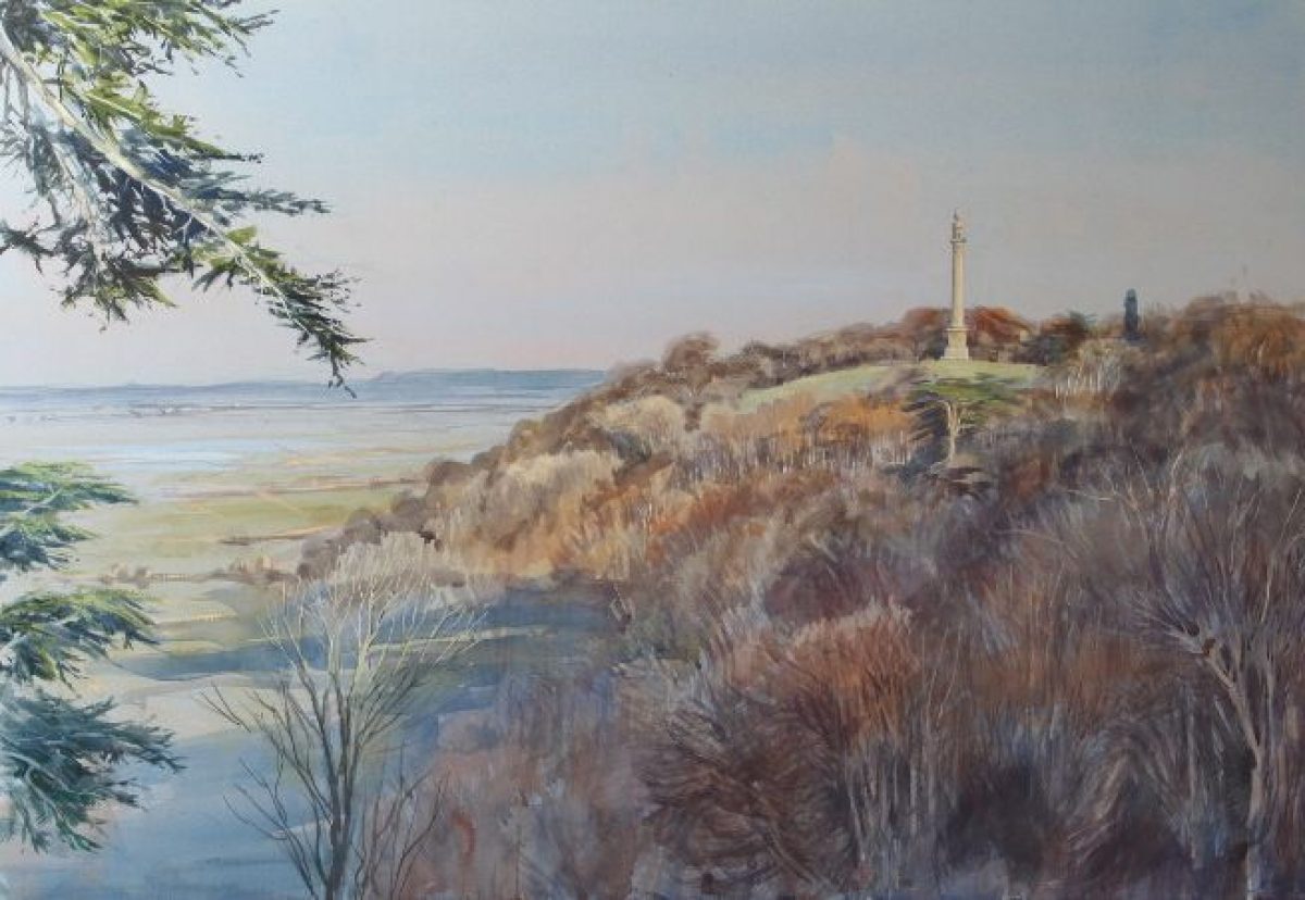
The site occupies a plateau of high ground which falls away steeply to the west and north-west, affording far-reaching views across West Sedge Moor towards the Quantock Hills.
The following is from the Register of Parks and Gardens of Special Historic Interest. For the most up-to-date Register entry, please visit The National Heritage List for England (NHLE):
A mid C18 landscape laid out by Lancelot Brown and William Pitt, Earl of Chatham, together with early C20 formal gardens designed by Harold Peto.
Location, Area, Boundaries, Landform and Setting
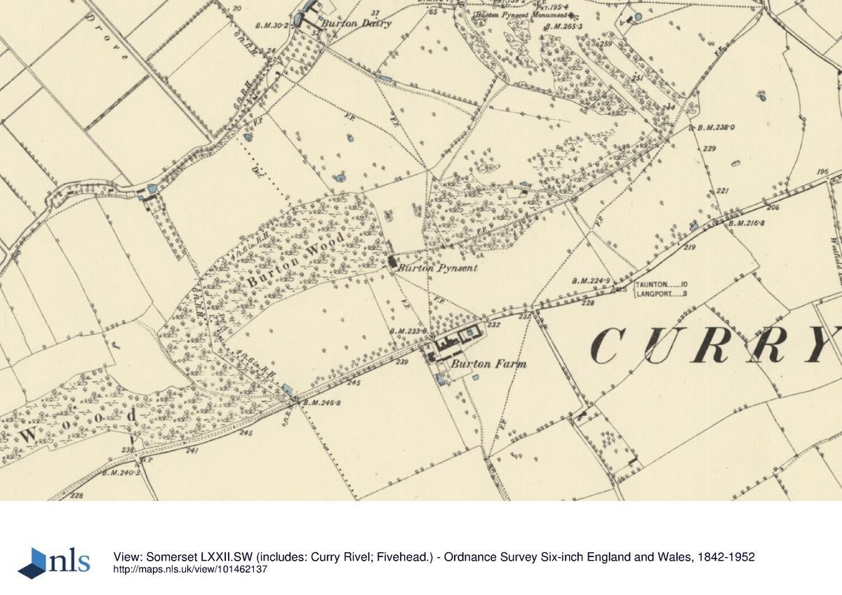
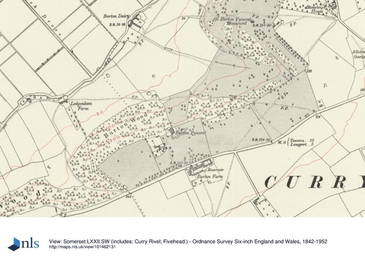
Burton Pynsent is situated c 1km west of Curry Rivel, to the north of the A378 road. The c 98ha site comprises c 1ha of formal gardens and pleasure grounds, and c 97ha of park and ornamental plantation. To the east and west the site adjoins agricultural land and woodland, from which it is separated by a variety of fences and hedges, while to the south the boundary is formed by the A378 road. The northern boundary is marked by a track, South Drove, and Burton Dairy Farm.
The site occupies a plateau of high ground which falls away steeply to the west and north-west, affording far-reaching views across West Sedgemoor towards the Quantock Hills. From the park to the south of the house there are also extensive views towards high ground c 10km south-east. The plantations on the west and north-west facing slopes within the park merge with areas of woodland beyond the boundaries of the registered site, including Swell Wood to the south-west and Stoneley Copse to the north-east.
Entrances and Approaches
Burton Pynsent is approached from the A378 road to the south at a point c 1.1km west of its junction with Westfield lane. The entrance is marked by a pair of mid or late C18 square brick piers with Ham stone cornices and finials, which are flanked by quadrant walls (all listed grade II) and which support a pair of C20 timber gates. From the entrance a straight tarmac drive extends c 190m north-north-west before sweeping north-east to enter the carriage turn to the west of the house. A spur leads west from the drive to provide access to the early C20 home farm and kitchen garden c 80m south-west of the house. The Tithe map (1841) shows a drive on approximately the alignment of the present approach, but leading to the south façade of the house. It appears that the present drive and the carriage turn to the west of the house formed part of the early C20 scheme of improvements implemented by Mrs Crossley with the advice of Harold Peto, in part to remedy problems created by the demolition of all of the original house except Pitt's mid C18 wing in 1805.
A further entrance to the site is situated to the east, on a minor road leading from Curry Rivel to Heale, at a point immediately south of a house known as Stoneleigh. Stone quadrant walls flank a pair of stone piers supporting metal gates which today (2002) serve this house, but which formerly led to a carriage drive extending westwards through the park. Some sections of this drive survive as public footpaths.
Principal Building
Burton Pynsent House (listed grade II*) stands on an artificially levelled terrace towards the south-western corner of the site. The classical-style house comprises two storeys and an attic, and is constructed in brick with ham stone dressings under a hipped tile roof. The principal façade faces east towards the garden, and is a symmetrical composition of seven bays with a central pediment, above which rises a small cupola. A centrally-placed door with a hood porch leads to a semi-circular flight of stone steps descending to the garden.
The south façade is of irregular design, with a regular section to the east representing the side of Pitts' mid C18 wing, with projecting bays to the west being of early C20 construction. The west or entrance façade is similarly irregular, with a tall projecting bay to the south-west comprising a triple-arched arcaded entrance at ground floor level beneath a large Venetian window and pedimented gable of C17 inspiration. The west façade was altered in the early C20 to regularise the house after the demolition, in 1805, of a large C16 and C17 mansion which extended to the west of the present house.
The core of the present house was constructed in 1765 for William Pitt, possibly to a design by Lancelot Brown (CL, 1934), who was designing the Pynsent Column for Pitt at the same period (Stroud, 1975; Bond, 1998). Although Pitt retained the earlier mansion to the west of his building, the landscape appears to have been designed to be viewed from the windows of his new wing and the terrace below (CL, 1934).
Gardens and Pleasure Grounds
The formal gardens are situated principally to the west, south and east of the house, with areas of informal pleasure grounds to the north-west.
The carriage turn to the west of the house is surrounded by areas of lawn and enclosed by ornamental shrubbery. From the south-east corner of the forecourt a gateway leads south to a walk which extends south for c 50m beneath a pergola of brick and timber construction. To the east, the pergola opens to a formal panel garden beneath the south façade of the house. This garden is ornamented with topiary, while a stone-paved walk leads east from the pergola, through the flower garden, to reach a rectangular lawn enclosed by yew hedges which form a semi-circular apse to the east. The lawn is planted with further topiary specimens. The southern end of the pergola opens eastwards into a pleached lime walk which extends parallel to the southern side of the flower garden and lawn, allowing southerly views across the park.
A terrace below the east façade of the house is enclosed by low stone balustrades, and is laid out as a further formal garden affording extensive views across the park towards the Pynsent Column and beyond across West Sedgemoor. A stone-flagged terrace extends below the walls of the house, with a further flagged walk extending eastwards on axis with the garden door in the centre of the façade to reach a low wrought-iron gate supported by low stone piers surmounted by ball finials. Panels of lawn flank this axial walk, while the corners adjacent to the house and the gate are marked by topiary globes. The wrought-iron gates lead to a flight of stone steps which descends to a mown grass walk extending eastwards beneath mature trees and flanked by ornamental shrubs forming a small woodland garden.
The gardens and pleasure grounds assumed their present form under Mrs Crossley in the early C20, and were laid out to the design of Harold Peto (Rockley, 1938). The Tithe map (1841) shows the park sweeping up to the south wall of the house, and the west garden, pergola, flower garden, south-east lawn and pleached lime walk were all laid out on areas taken in from the park or from a shrubbery to the west of the house. The east terrace garden occupies the site of a terrace which is shown on the Tithe map (1841), and which appears to have been constructed at the same time as Pitt's east wing to provide a platform from which to view the landscape. Philip Pear of Curry Rivel supplied Pitt with seats and Chinese railings for the terrace (Bond, 1998). The present arrangement of the walks and lawns formed part of Peto's early C20 scheme, as did the gate leading to the woodland garden beyond.
Park
The park is situated principally to the east and north-east of the house, with further, smaller areas to the south and south-west. Today (2002), the park is in mixed agricultural cultivation, with pasture predominating to the north-east and arable land to the east and south of the house. While many scattered specimen trees survive within the park, comparison of the early C20 OS (OS, 1930) and the Tithe map (1841) indicates that the number of park trees has declined significantly since the late C18, a process continued by late C20 storm damage.
To the south and south-west of the house the boundary between the park and the A378 road is screened by remnants of a double row of trees (Tithe map, 1841), while to the south-east the remnants of a triangular-shaped plantation adjoining the boundary (Tithe map, 1841) may have been intended to direct a south-easterly vista from the east terrace. In the 1770s, Pitt wrote that the park to the south of the house was 'finely wooded with large elm and other trees, and commanding a very fine view to the south, south-east and south-west, bounded by that high ridge of land which, stretching from pleasure grounds on the brow of the hill are elegantly disposed, and admit of great variety' (Garden Hist 1996).
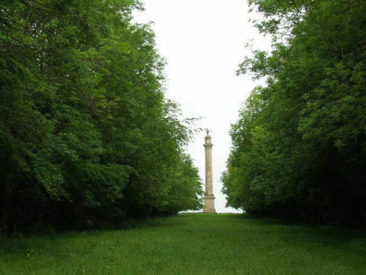
Some 400m east-north-east of the house, and on axis with the east façade, the remnants of what appears to be an avenue of mature limes extends for c 200m, marking the south side of an earthwork terrace which looks north-west down the valley separating the house from Troy Hill, the site of the Pynsent Column, to the north-east. The function and origin of this feature is unclear, but it appears to support a carriage drive which continues east-north-east on the line of a public footpath for c 150m before reaching the southern end of a ride c 50m wide which leads c 400m north-west to the Pynsent Column. The ride, which is recorded on the Tithe map for Drayton parish (1822), recalls the 'Grecian Diagonal' at Stowe (qv), a similar broad ride which frames a vista of the Cobham Monument.
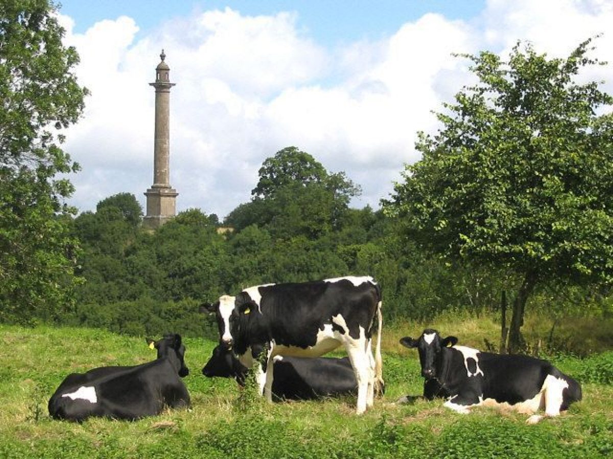
The Pynsent Column (listed grade I) stands on Troy Hill, a spur of high ground c 700m north-east of the house and visible in reciprocal vistas from Pitt's east wing and terrace. The Roman Doric Column stands c 42m high with a square pedestal set on a square stepped podium enclosed until the Second World War by metal railings. It is surmounted by a cupola with an urn finial which replaced the original statue representing 'Gratitude conveying to Posterity the name of Pynsent' in the late C19 (Bond, 1998). The column is constructed in local lias quarried on the estate, encased in an outer shell of Portland stone, with an internal staircase (now sealed) leading to a prospect terrace accessed through the cupola. An inscription records that Pitt erected it to commemorate Sir William Pynsent's benefaction. The Column was constructed in 1765-7 to the design of Lancelot Brown by the local builder Philip Pear at a cost of £2,000. The structure shares some features of design with Brown's earlier column of 1747-9 commemorating Lord Cobham at Stowe. The Pynsent Column is the focal point for a series of designed vistas within Pitt's landscape; it is also a prominent feature in the wider landscape and features as the focus of a vista from the contemporary pleasure grounds of Hatch Court (qv), c 7km south-west of Burton Pynsent.
The steep north and north-west facing slopes within the park are planted with blocks of ornamental plantation which are broken to allow vistas down valleys to the lower park and West Sedgemoor beyond; some of these vistas were aligned on the towers of local churches (Garden Hist 1996). While much C20 replanting has taken place, the slope c 100m north-east of the house, which appears to correspond to the bare open hillside which Pitt considered to spoil the view, retains some of the cedars and other trees which he ordered to be planted (ibid; Bond, 1998).
Some 250m north-east of the house, the park is crossed by a lane leading from the A378 road to Burton Dairy Farm. Where the lane passes across the eastward vista from the house, it is sunk from view; this work formed part of Pitt's mid C18 development of the park (Garden Hist 1996; Bond, 1998). Within the park and immediately north of this track, a spring is impounded in an artificial, stone-edged pool, apparently as an ornamental feature.
Kitchen Garden
The kitchen garden is situated c 80m west-south-west of the house, to the west of the drive and immediately north of Burton Pynsent Cottages. The garden appears to form part of the early C20 scheme of improvements undertaken by Harold Peto for Mrs Crossley, and was developed on an area which in 1841 formed part of the south park (Tithe map, 1841). There is no evidence relating to the location of the mid C18 kitchen garden, although it is possible that it lay outside the park adjacent to Burton Farm, south of the A378 road and c 100m east of the present entrance.
William Pitt is known to have ornamented agricultural buildings on the estate with Tuscan columns, and in 1770 commented to his wife that the 'dairy [was] enchanting' (Garden Hist 1996). These buildings were either situated outside the park, or do not survive above ground.
Maps
- Tithe map for Drayton parish, 1822 redrawn 1840 (M5146/1), (Somerset Record Office)
- Tithe map for Curry Rival parish, 1841 (M5136/1), (Somerset Record Office)
- OS 6" to 1 mile: 1930 edition
Archival items
- Lord Chatham's papers, including correspondence, plant lists and plans, are held at the Public Record Office.
Description written: December 2002
Register Inspector: JML
Edited: July 2021
- Visitor Access, Directions & Contacts
Owners
Mr & Mrs T Schroder
- History
The following is from the Register of Parks and Gardens of Special Historic Interest. For the most up-to-date Register entry, please visit The National Heritage List for England (NHLE):
16th - 18th Century
An engraving of the house at Burton Pynsent as it existed before 1765 shows it to have been an irregular structure which clearly evolved over a protracted period (Collinson, 1791). This process appears to have been commenced by Marmaduke Jennings c 1565, and to have been continued in the early C17 by his successor, also Marmaduke Jennings (CL, 1934). In 1679 Thomas Jennings died leaving the estate to a female relation, who married as her second husband ,Sir William Pynsent. Their only son died in 1754, and late in life Sir William appears to have developed an interest in politics.
Disillusioned by the dismissal from the government of William Pitt (1707-78) in 1761, and angered by Lord Bute's proposal in 1763 for a tax on Somerset cider which enjoyed the support of his putative heiress' husband, Lord North of Wroxton Abbey, Oxfordshire (qv), Sir William Pynsent made a new will in 1764 bequeathing his Somerset estate to Pitt. Pynsent died in 1765, and despite challenges to the will mounted by relations who had been left 1,000 guineas each, which continued until 1771 (Stroud, 1975), Pitt immediately travelled to Somerset to inspect the estate, writing to his wife that 'I propose to pass the rest of my days [there] if I find the place tolerable' (CL, 1934). Political commitments prevented Pitt, who was created Earl of Chatham in 1766, from taking up residence at Burton Pynsent until 1767, but as early as September 1765 he had commissioned Lancelot Brown (1716-1783), whom he had originally met at Stowe, Buckinghamshire (qv), to design a column commemorating Sir William Pynsent's benefaction. Brown also appears to have advised on the formation of the park landscape, and may have been responsible for the design of a new wing which Pitt constructed at the eastern end of the existing house in 1765-7 (ibid). The Pynsent Column was built by Philip Pear, a builder from Curry Rivel, at a cost of £2,000, and was also completed in late 1767 (Bond, 1998).
Lord Chatham continued to reside periodically at Burton until his death in 1778 and he himself directed improvements to the landscape including extensive tree-planting (ibid). The species planted included more exotic subjects and large numbers of cedars, many being supplied by London nurserymen including John Brodrick (Garden Hist 1996); while Capt. Samuel Hood sent black spruce from Nova Scotia (Bond, 1998). In 1768 Chatham repurchased his previous seat at Hayes Place, Kent which had been sold in 1766, the repurchase being financed by the sale of part of the Burton estate. After Lord Chatham's death his widow, and his granddaughter, Lady Hester Stanhope (1776-1839) lived at Burton until the death of Lady Chatham in 1803.
19th - 20th Century
The estate was offered for sale in lots in 1805, the house and park being sold to a speculator for £8,810. It was immediately re-sold to Col Pinney who demolished all but the mid C18 wing of the house. The Pynsent Column had been purchased by Dr Woodford of Taunton, Lord Chatham's physician, in order to prevent its destruction, and was subsequently conveyed to Col Pinney. The estate was owned by a series of non-resident proprietors in the C19, finally being sold in 1909 to Mrs Crossley, a relation by marriage of Harold Peto (1854-1933). Peto was commissioned to lay out formal gardens to the east and west of the C18 house, which was also provided with a new entrance front to the south-west (CL, 1934; Rockley, 1938). Burton Pynsent is one of a group of sites in Somerset and Dorset, including Wayford Manor (qv) and Seaborough Court, at which Peto worked for his relations during a period when he was officially barred from practising in England under the terms of the dissolution of his partnership with Sir Ernest George in 1892.
Burton Pynsent remained the property of Mrs Crossley's descendants until being sold in the late C20. Today (2002), it remains in private ownership.
Period
- 18th Century (1701 to 1800)
- Late 18th Century (1767 to 1800)
- 20th Century (1901 to 2000)
- Early 20th Century (1901 to 1932)
- Associated People
- Features & Designations
Designations
The National Heritage List for England: Register of Parks and Gardens
- Reference: GD2142
- Grade: II
Plant Environment
- Environment
- Walled Garden
- Woodland Garden
- Plant Type
- Flower Garden
- Kitchen Garden
- Rose Garden
Style
- Brownian Landscape
- Italianate
Features
- House (featured building)
- Description: Only the mid-18th century wing of the house survives.
- Earliest Date:
- Latest Date:
- Kitchen Garden, Lawn, Avenue, Herbaceous Border, Rose Garden, Terraced Walk, Pleached Trees
- Key Information
Type
Garden
Purpose
Ornamental
Plant Environment
Environment
Principal Building
Domestic / Residential
Period
18th Century (1701 to 1800)
Survival
Extant
Hectares
98
Open to the public
Yes
Civil Parish
Curry Rivel
- References
References
- {English Heritage Register of Parks and Gardens of Special Historic Interest}, (Swindon: English Heritage, 2008) [on CD-ROM] Historic England Register of Parks and Gardens of Special Historic Interest
- Stroud, D., {Capability Brown} (London: Faber, 1975), pp. 135-6, 219 Capability Brown
- Bond, J., {Somerset Parks and Gardens} (Tiverton: Somerset Books, 1998), pp. 89-90 Somerset Parks and Gardens
- Pevsner, N., {The Buildings of England: South and West Somerset} (Harmondsworth: Penguin, 1958), p. 111 The Buildings of England: South and West Somerset
- Dunning, Robert: 10th September 1987, pp166-167 Country Life
- Collinson, J., (1791), p 24 History and Antiquities of the County of Somerset
- Lady Rockley., (1938), p 172-3 Historic Gardens of Somerset
- (1996), pp129-30 Garden History
Contributors
Lee, Caroline
Mullineux, Alastair
Stirling, Mary
- Related Documents
-
CLS 1/1167-8
A History of the Landscape, Pts. 1 and 2
Debois Landscape Survey Group - 2002
-
CLS 1/1167-8