Introduction
Hestercombe House is set in 120 hectares of parkland. There is a formal garden of around 3 hectares beside the house, designed by Edwin Lutyens and Gertrude Jekyll from 1904 to 1908. There is also a landscaped valley behind the house of around 13.5 hectares, created by Coplestone Warre Bampfylde between 1750 and 1790.
Terrain
The site slopes from north to south, with a steep-sided combe, Hester Combe.
A mid and late 18th-century landscaped garden created by Coplestone Warre Bampfylde and early 20th-century formal gardens designed by Sir Edwin Lutyens, with planting by Gertrude Jekyll, set within wider parkland developed in part from the mid-18th century.
The house is on a site of Saxon habitation. The Queen Anne house was modernised during Victoria's reign - of little interest.
Regarded by Christopher Hussey as the best surviving example of the partnership between Edwin Lutyens (1869-1944) and Gertrude Jekyll (1843-1932). Commissioned in 1904 by Hon E W B Portman, on the southern side of the existing house, Lutyens created a series of different spaces set on varying levels arranged around a large sunken sheltered square called the plat. East and west sides have rills flowing to tanks sited on the pergola, where extensive views over Taunton Deane are obtained.
Miss Jekyll provided the distinctive character to each area to compliment the architectural structure. Grey walk most typical of Jekyll's approach to planting contrasts with the formality of the plat.
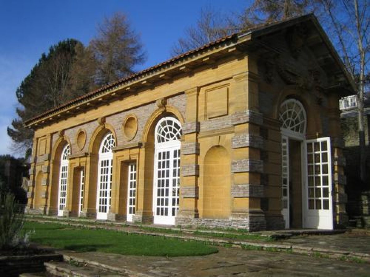
The only building by Lutyens, The Orangery, in 1904 (tea house folly) in his 'Wrenaissance' style. The Dutch garden beyond the building should be the East garden.
The Bothy is now a private house. The renovation of the planting started in 1974. Planting used in an architectural way to contrast and support elements. The relationship between plants considered important.
The following is from the Register of Parks and Gardens of Special Historic Interest. For the most up-to-date Register entry, please visit The National Heritage List for England (NHLE):
Location, Area, Boundaries, Landform and Setting
Hestercombe is situated some 3.5km north-north-east of Taunton, and c 1km north of the village of Cheddon Fitzpaine. The c 120ha site comprises some 3ha of formal gardens and pleasure grounds around the House, c 2ha of walled gardens, c 15ha of mid and late C18 pleasure grounds, and c 100ha of parkland and ornamental woodland. The site is bounded to the west by a minor road, Pitcher's Hill, while to the south the boundary is formed by Hestercombe Road. To the north-west, north, north-east, and east the site adjoins agricultural land and is enclosed by hedges and stone walls.
The site slopes from north to south, with a steep-sided combe, Hester Combe, running c 800m north-north-east from the House. A further, smaller combe, West Combe, extends north from the principal drive at a point c 300m west of the House. There are extensive views south across the Vale of Taunton to the Blackdown Hills from the terraces south of the House, and from the higher walks in the C18 pleasure grounds north of the House. The towers of the Taunton churches, and Creech Barrow, a prominent tumulus north-east of Taunton, are significant features in the longer views from the site, while agricultural land north of Taunton forms a foreground to the extended views.
Entrances and Approaches
Hestercombe is approached from Pitcher's Hill. Concave stone wing walls extend from rusticated stone piers with pyramid caps to flank the entrance, which was formerly marked by further rusticated stone piers (demolished c 1952). Opposite the entrance, to the west of Pitcher's Hill, stand Park Gate Cottages, a pair of late C19 gabled stone cottages placed on the axis of the drive. To the north of the entrance stands a similar pair of late C19 stone cottages. The tarmac drive passes c 130m east through an avenue of lime trees planted in 1973-5 to replace an avenue of elms felled in the 1950s, before sweeping east and east-south-east across the park for c 480m to arrive at the carriage court below the west façade of the House. Here a central elliptical lawn reflects the arrangement shown in a mid C18 watercolour by Coplestone Warre Bampfylde. A drawing dated 1700 (reproduced in Pearson Assocs 1998) shows a walled formal garden or forecourt below the west front of the House, with the medieval chapel and C17 stable block in a further walled enclosure to the north-west. This arrangement is shown in a portrait of C W Bampfylde painted by John Wootton c 1741.
A late C19 or early C20 drive enters the site from the south-west, at a point adjacent to the junction of Pitcher's Hill with the minor road leading south to Rowford, c 850m south-west of the House. Low stone concave wing walls flank wooden gate piers surmounted by ball finials, which support a single timber gate of pale construction. Immediately to the west of the entrance stands South Lodge, a late C19 Tudor-gothic stone lodge with gables and tall chimneys. The south-west drive passes north for c 400m through Sandilands, an area of ornamental woodland planted c 1900, to reach Hestercombe Road. On the north side of the road Middle Lodge, a late C19 gabled stone lodge, stands to the east of a further timber gate of lattice construction which is supported by square-section stone piers surmounted by pyramid caps and flanked by low stone wing walls. The drive sweeps north and north-east for c 430m through the park to join the principal drive c 200m west of the House. The south-west drive formed part of improvements to the estate undertaken by the Edward Portman in the late C19 and early C20. The drive is today (1999) disused and survives as a track.
A further drive approaches the House from the east, entering the site adjacent to Gotton Lodge, a late C19 gabled stone lodge which stands to the north-east of a pair of square-section stone gate piers which are surmounted by pyramid caps. The east drive passes for c 350m through Gotton Copse, a plantation of C18 origin, before continuing south-west for c 250m to approach the service area to the south and east of the House. The east drive existed by 1741 (Pearson Assocs 1998) and was altered to its present form by Edward Portman in the late C19. Today (1999) a late C19 or early C20 drive extends from the service area east of the House, to the Home Farm and Hestercombe Road c 250m south-east of the House. The late C19 OS map shows Hestercombe Road extending only to the south-east corner of the walled garden, where a drive entered the site, passing north and east across the park to reach Home Farm. Hestercombe Road was extended east to Gotton as part of the Portmans late C19 or early C20 estate improvements, and is shown in its present form on the 1904 OS map.
Principal Building
Hestercombe House (listed grade II*) contains elements of a late C15 and C16 house, together with C18 elements which were built for John Bampfylde (d 1750) and his son, Coplestone Warre Bampfylde (d 1791). The C18 house was a two-storey Palladian structure, with projecting wings flanking the entrance on the west front and a pedimented south façade (Collinson 1791; White 1995). In 1875 the first Viscount Portman commissioned extensive alterations to the House, which included the construction of an upper storey, and the erection of a porte-cochere on the west façade. A tall water tower was constructed at the north-west corner of the House. The late C19 work adopted an Italian villa style, with a mixture of French and Greek details. Early C20 photographs show that the stuccoed south façade was then obscured by heavy planting, providing an appropriate backdrop to the garden terraces. Some 60m north-west of the House and immediately north of the drive stand late C17 stables, altered in the late C19 and incorporated into the south range of stables which were built in the late C19.
Gardens and Pleasure Grounds
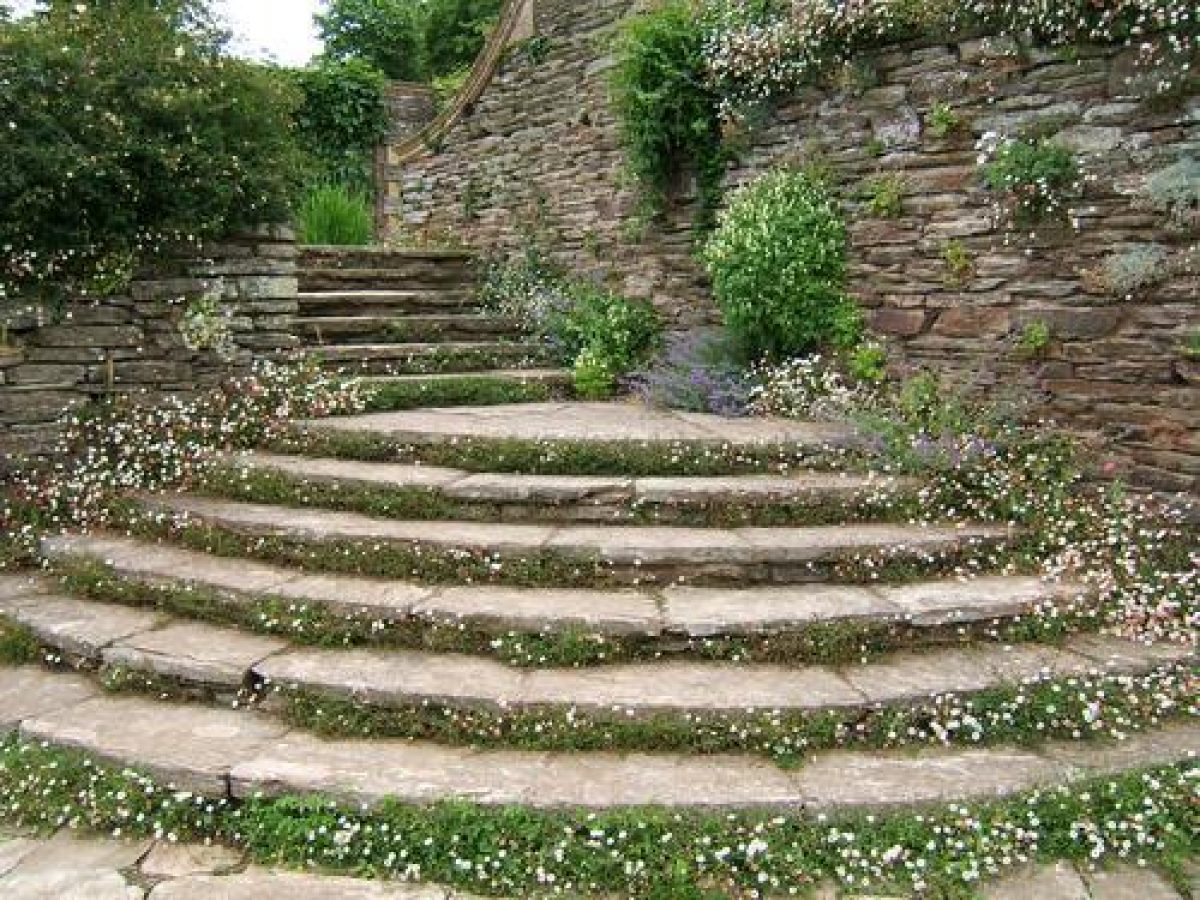
Lying to the north and south of the House, the gardens comprise the C18 landscape created in Hester Combe by Coplestone Warre Bampfylde, and the early C20 terraces and pleasure grounds designed by Edwin Lutyens and planted by Gertrude Jekyll. The two areas of the garden are linked by a monumental flight of stone steps known as the Daisy Steps, designed by Edwin Lutyens after 1908 (Country Life photographs), which descends a terraced grass bank c 30m north-west of the House to connect the C18 landscape garden to the carriage court west of the House. The axis of the Daisy Steps is continued south of the carriage court by a flight of semicircular concave-convex stone steps (closed by a yew hedge, planted 1990), which approach a walk forming the west boundary of the early C20 formal gardens which leads to the walled gardens c 270m south-west of the House.
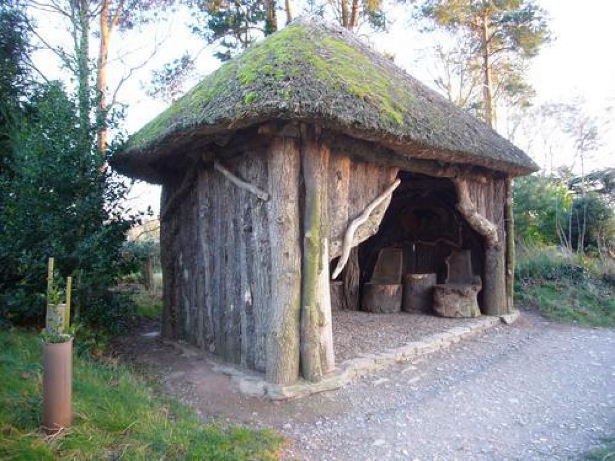
The Daisy Steps ascend to a terrace walk of C18 construction bounded to the south by a low stone wall which connects the landscape garden to the stables. This is today (1999) used as the principal public access to the site, with the car park lying to the north-west of the stables. Some 50m east of the Daisy Steps, the slope north of the House and above the service drive has been planted as a late C19 shrubbery garden to a design by Kim Leggatt (1999). Serpentine gravel walks pass through lawns and ornamental planting, with mature cedars and a late C19 yew tunnel running north-east towards the C18 landscape garden. Some 80m north-east of the House, archaeological investigation has revealed (1999) the site of the octagon summerhouse; constructed by C W Bampfylde, this was described by Edward Knight in 1761. This building had views south across the park and Taunton Deane towards Creech Barrow.
The combe was originally woodland on the site of a Saxon settlement. The estate was inherited in 1750 by Coplestone Warre Bampfylde and developed the combe in the picturesque style with waterfalls, rills, a temple and other buildings in the classic style after the pictures of Claude.
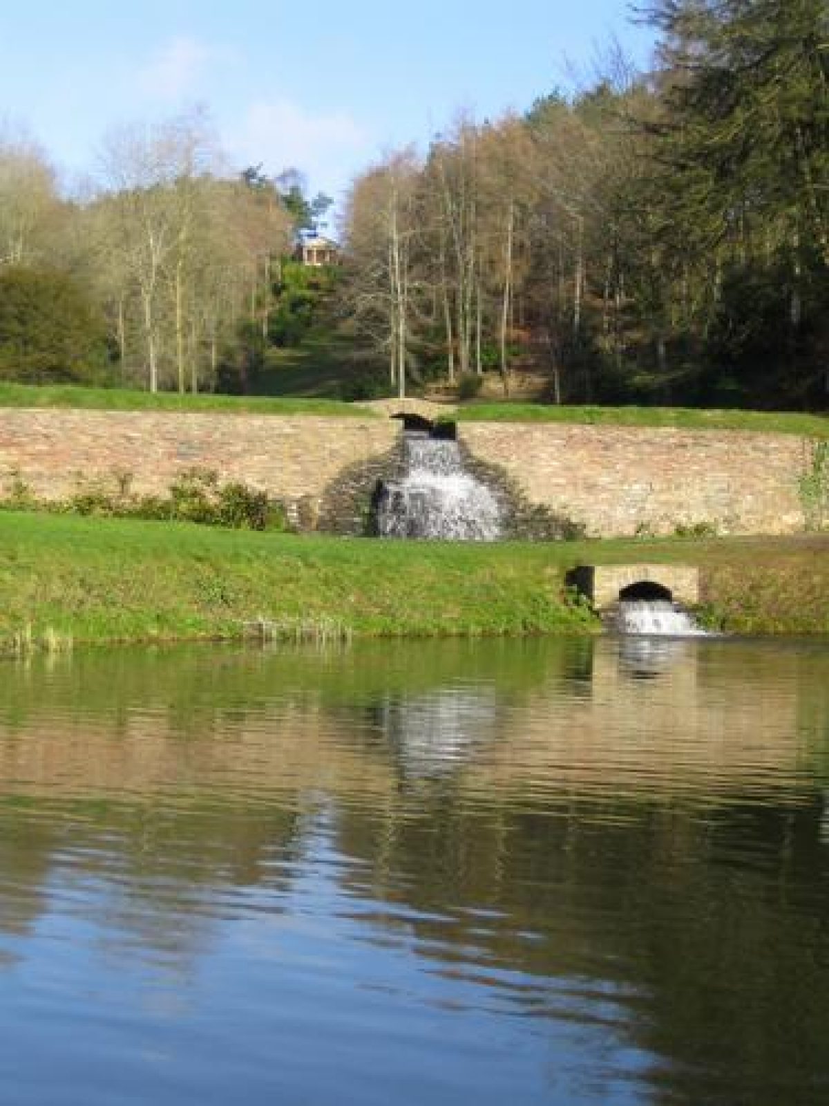
The combe which runs north and north-north-east from the mill pond c 50m east of the House was developed as a landscape garden by C W Bampfylde between 1750 and his death in 1791. To the north of the mill pond, grass banks and drystone retaining walls with a central stepped cascade retain the Pear Pond, named for its shape on plan. From the walk across the dam at the south end of the Pear Pond, there is an extensive view north and north-east up the combe to Pope's Urn, and to the Temple Arbour (listed grade II*), a pedimented Tuscan structure built by Bampfylde in the mid 1770s (guidebook) and restored in 1996-7. This stands on high ground c 350m north-east of the House. This view was painted by Bampfylde in the late C18. The Temple Arbour affords wide views south-west and south across the combe, park, and Vale of Taunton, to the Blackdown Hills beyond, and to the Great Cascade c 80m west-south-west.
A level terrace walk, above and to the west of the Pear Pond, passes a classical stone urn and pedestal erected by Bampfylde in 1786 (late C20 copy of the original) to record his friendship with Charles Tynte of Halswell Park, and Henry Hoare of Stourhead (qqv); and c 200m north-east of the House, the site of the mid C18 Chinese Seat, which was removed by the late C19. To the east of the Pear Pond, a west-facing sloping lawn ascends to the Mausoleum (restored 1996-7, listed grade II*), c 160m north-east of the House. Constructed in the 1750s by Bampfylde to his own design (guidebook), the west façade has an arched entrance with vermiculated, rusticated keystones, which is flanked by ashlar piers with vermiculated, rusticated bases, which support carved stone urns with flame finials. The façade sweeps up to a central truncated obelisk which rests on a rusticated plinth. The apsidal interior of the Mausoleum has a westerly view across the Pear Pond to the Friendship Urn, which is framed by the arched entrance.
A path ascending to the south-east of the Mausoleum leads to a knoll from which a mid C18 'capriccio view' (restored 1999) reveals the obelisk finial and the site of the Gothic Alcove c 425m north-north-east across a meadow, in alignment. A shallow cascade at the north end of the Pear Pond is overshadowed by a mature yew, while to the north-east of the Pear Pond, c 200m north-east of the House, a classical urn after that designed by William Kent for Alexander Pope (restored 1998) stands on a south-west-facing grass slope, below the woodland.
In the combe north of the Pear Pond, the stream descends a series of cascades ornamented with pieces of white quartz, known as the Valley of Cascades (Edward Knight, 1761). Some 270m north-east of the House a lawn planted with flowering shrubs and ornamented with white quartz boulders allows a view of the Great Cascade, which descends a picturesque rock face. Inspired by a visit to The Leasowes, Halesowen (qv) in 1762 (White 1995; guidebook), the Great Cascade is supplied by a brick-lined leat fed from the Box Pond c 580m north-north-east of the House. The leat passes along the west side of the combe, and has a terrace walk on its east side from which there are a series of picturesque views into, and along the valley.
Opposite the foot of the Great Cascade is the site of the Rustic Seat, a mid C18 structure (guidebook). From the foot of the Great Cascade a walk ascends north on the west side of the combe, passing through an area of light woodland to reach the dam at the southern end of the Box Pond, which has a centrally placed stone cascade (recreated 1998), flanked by yews and box. In the valley north-east of Box Pond a further two C18 lakes are now (1999) heavily silted. On a knoll above the east bank of Box Pond is the possible site of an C18 classical rotunda (P White pers comm, 1999). To the south-east of Box Pond, c 600m north-east of the House, a zig-zag path (restored 1997) following its mid C18 course (guidebook), ascends the west-facing valley side to a walk which follows the eastern boundary of the combe. Some 600m north-east of the House a spur of shrubbery extends east for c 100m to the site of the Gothic Alcove (foundations excavated 1998), a structure constructed by Bampfylde before 1761 (White 1995) and demolished in the late C19. The Gothic Alcove enjoyed wide views from east to south-west across an ornamental meadow, from which it was separated by a stone ha-ha, towards Taunton and Taunton Deane.
To the east of the Gothic Alcove a small gate flanked by rustic circular piers gave access to walks in the meadow, and allowed views east and south-east to woodland. To the south, the eastern boundary walk is bordered to the west by precipitous drops into the valley, and reaches the Temple Arbour, c 250m to the south-south-west. The Temple Arbour (restored 1997) affords views south across the gardens and park to Taunton. Some 75m further south, and c 300m north-east of the House, the Witch House, a picturesque rustic timber and thatch structure with a cobbled floor, affords a view west to the Great Cascade; the original building was in existence before 1761. The present structure was recreated by David and Andrew Raffle in 1998, following early C20 photographs. From the Witch House, the upper east walk continues south, descending to reach the Mausoleum on the east side of the Pear Pond.
The gardens to the south of the House comprise a series of formal terraces, with an area of formal and informal gardens to the south-east. Immediately below the south façade of the House, a rectangular terrace with a central late C19 cast-concrete tazza fountain set in a circular kerbed basin is laid out with four rectangular panels of grass set with rectangular beds of seasonal plants, separated by gravel walks. To the east, south, and west the terrace is enclosed by stone balustrades (listed grade I). The terrace was constructed in the late C19 for the first Viscount Portman to a design by the London architect Henry Hall (guidebook), and was restored in 1997-8. Below and to the east and west of the late C19 terrace, Edwin Lutyens constructed further terraces in 1904-06 for Edward Portman. To the west, stone steps descend from the late C19 terrace to the early C20 rose garden (restored 1974), a rectangular enclosure bounded by walls and yew hedges to the east and west and a stone balustrade to the south, with a central stone-lined and kerbed rill dividing lawns with rectangular panel rose beds.
To the north, benches to a design by Lutyens stand within an arched arbour formed from wych elm. The Venetian well-head shown in early C20 photographs to the south of the arbour does not survive. To the east of the late C19 terrace, an entrance flanked by square-section stone piers leads to the Rotunda, a circular walled enclosure with geometric stone flags and a central circular pool (restored 1991). To the north, a tall arched recess is surmounted by a pediment and winged putto keystone and is flanked by circular niches with carved brackets which are repeated on the south-east and south-west walls. To the north-east further square-section piers flank the entrance to the Orangery Terrace. The Rotunda is the pivotal feature of Lutyens' design, a role emphasised by the patterned stone paving which radiates from the central pool. The significance of the Rotunda within the overall scheme is reflected in the variety and detail of the stone and finishes employed (Jane Brown pers comm, 1999).
South of the Rotunda, piers formerly surmounted by lead figures of cherubs supporting baskets (Country Life photographs) flank a broad flight of stone-flagged steps which descends to a paved terrace enclosed to the south by stone balustrades, and to the east and west by ornamental shrubs. From the southwest corner of this terrace, and from the southeast corner of the Rose Garden, stone steps descend to the second principal terrace. Here a central lawn is enclosed by shaped stone flags, while to the north a border planted to a scheme by Gertrude Jekyll with silver and grey plants (restored 1973) is supported by a drystone planted wall. There is a similar, level border to the south of the lawn.
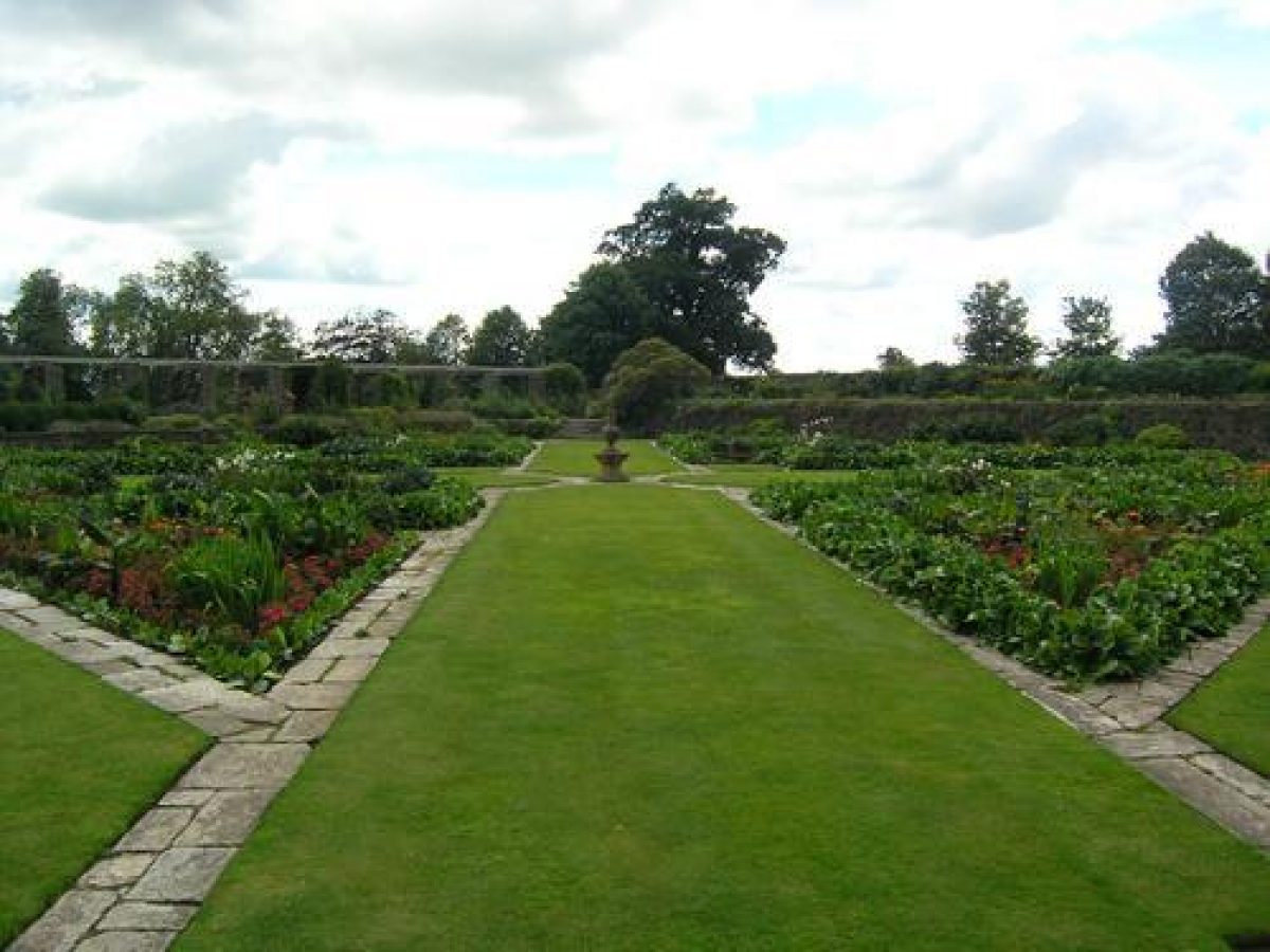
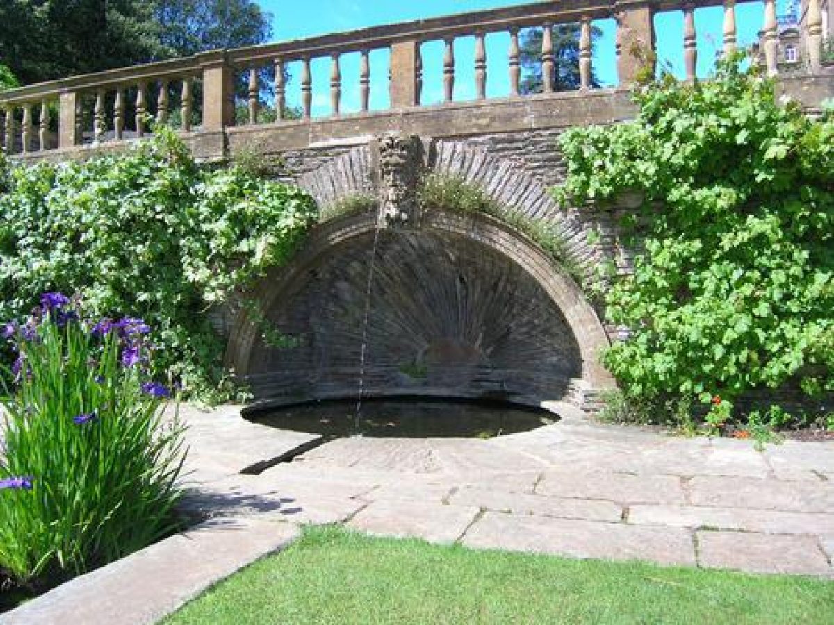
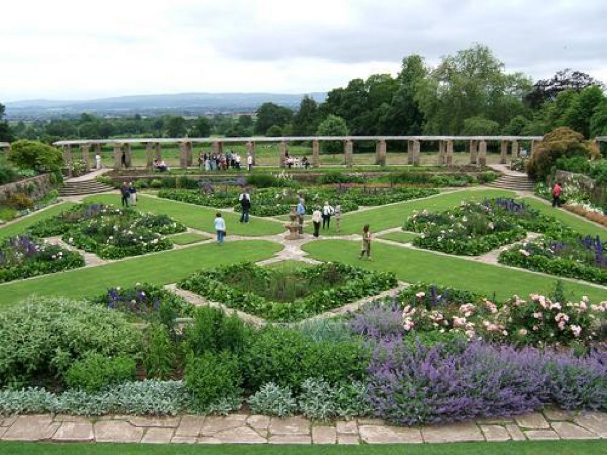
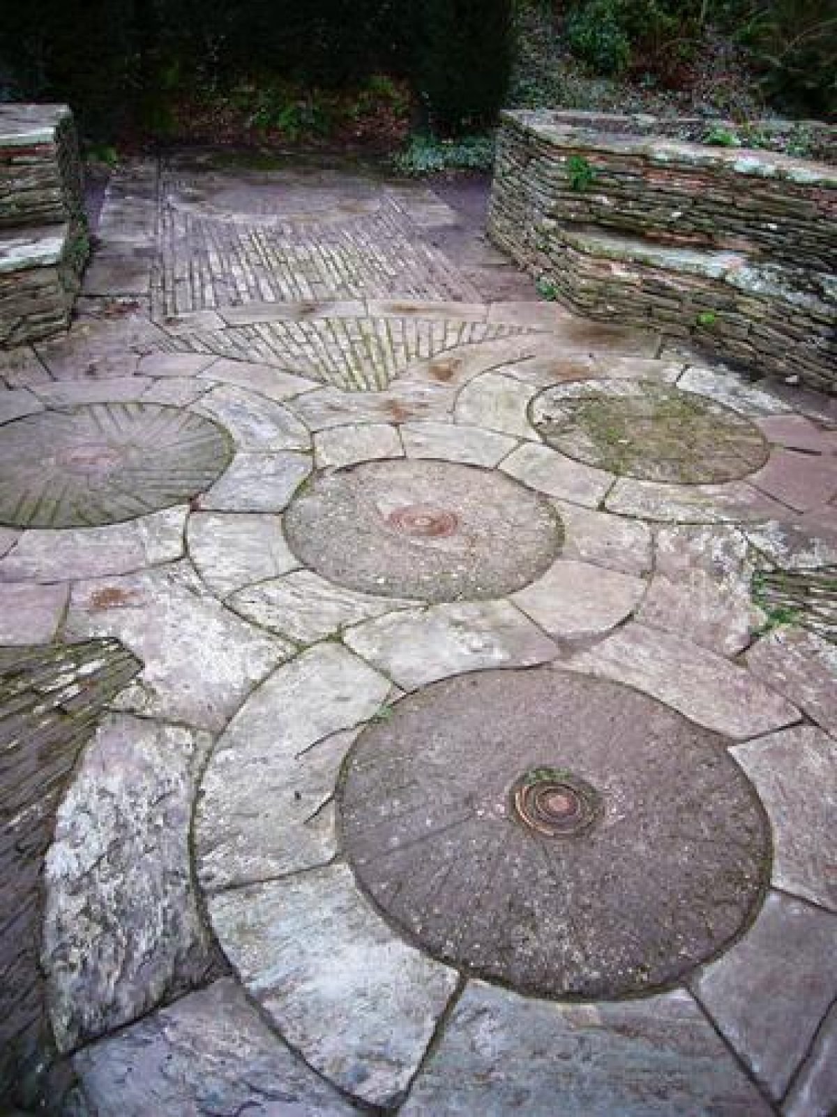
Stone steps descend east and west from the second terrace to a pair of symmetrical water garden terraces which enclose a large sunken garden, the Great Plat. Rectangular on plan, the water gardens each have a stone-lined and kerbed rill on their north to south axis, with three pairs of small circular pools that mark descents in level. The circular pools are of varying depths to accommodate different water plant species (Jane Brown pers comm, 1999). The rills divide lawns which are edged with stone flags and flanked by mixed borders planted to schemes designed by Gertrude Jekyll (restored 1974). To the north of the water garden terraces, swept-down walls partly enclose flagged areas, with a circular pool set into the north retaining wall. Mask fountains on the arch keystones, a male mask to the west and female to the east, feed simple jets into the pools below, which in turn supply the water garden rills. The fountain arches are flanked by circular niches similar to those in the Rotunda. To the south of the water garden terraces the rills discharge down simple cascades into square tanks with stone stepped margins. The bases of the rills and square tanks are lined with thin stones set on edge which are visible under the water (Brown 1982).
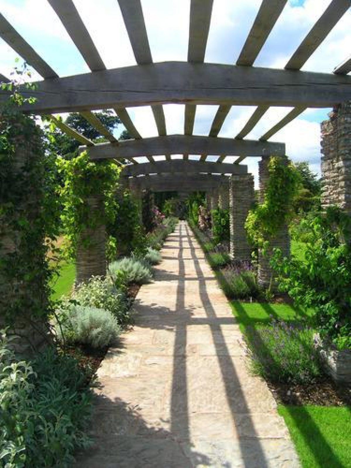
The tanks adjoin the pergola, a structure with alternate massive circular and square-section piers extending c 80m from east to west, which supports a slightly arched timber superstructure constructed from oak beams. The pergola is planted with roses and climbers and encloses the south side of the Great Plat. The pergola (restored 1973) contains a flagged walk and affords views north across the gardens and terraces to the House, and south across a level lawn, partly planted as an orchard, and over the park to adjoining country. Stone walls at the east and west ends of the pergola contain oeil-de-boeuf-shaped openings, which frame further outward views. The Great Plat is a level, sunken garden, square on plan, with stone quadrant steps at each corner connecting to the adjacent terraces. Geometric-shaped panels of lawn enclosed by stone flags extend diagonally across the garden from each corner, meeting at a central stone baluster sundial. The triangular areas formed by the panel lawns to the north, south, east, and west are divided by stone flags into geometric beds planted in accordance with Jekyll's scheme of 1906-07 (restored 1975, replanted following Jekyll's scheme 1998).
The structural elements of the south terraces are all listed grade I. Lutyens' scheme makes subtle use of a variety of stones and textures which have 'been carefully graded to the importance of the elements' (Brown 1982) and their relation to the other elements of the design (Jane Brown pers comm, 1999).
To the east of the Rotunda, stone steps descend to a square paved area below the south-west façade of the early C20 Orangery (listed grade I). Constructed in 1904-09 to the design of Edwin Lutyens, the Orangery faces south-east across a terrace and lawns. The single-storey Baroque-style structure is built in Ham Hill stone and local morte-slate, with tall arched windows in the south-west, south-east, and north-east façade. It is built against a bank to the north-west, from which pipes fed a pair of stone cisterns (dry, 1999) set in arched recesses to either side of a stone fireplace. Below the south-east façade of the Orangery an east to west terrace has geometric panels of lawn enclosed by stone flags, and a central circular rill (dry, 1999), fed from the basins within the Orangery. Rectangular beds to the south-east are separated by three broad flights of stone steps, which descend to a narrow flagged walk above a level lawn. Some 50m to the south the lawn falls in a gentle slope to an area of mixed informal planting. Several mature sweet chestnuts survive from the mid C18 park (guidebook). To the south-east, an area of mixed planting around a watercourse was designed by Jekyll in the early C20 as a bog garden (Pearson Assocs 1998), while an arched gate with a fretwork panel in the east boundary wall was designed by Lutyens to allow a glimpse into the lane beyond the garden. To the south-west the Orangery garden is enclosed by the buttressed rubble-stone retaining wall of the east Water Garden Terrace, against which specimen trees and shrubs are planted. Stone steps at the southern end of this wall ascend to a wrought-iron gate which leads to the east end of the pergola.
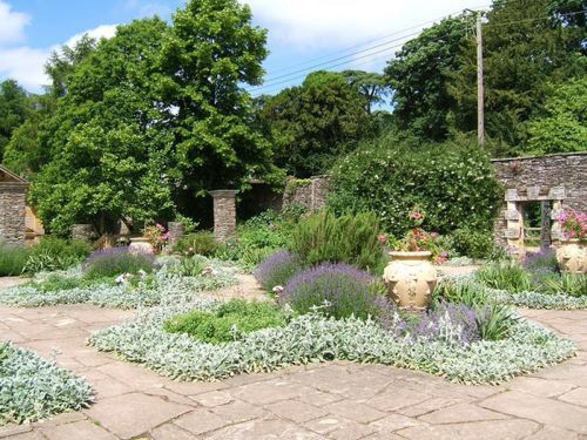
North-east of the Orangery, further stone steps flanked by circular and square-section piers ascend from a square flagged area to the Dutch Garden (restored 1976), a raised terrace, square on plan, which is divided by stone-flagged walks into a series of geometric beds. Planted according to Jekyll's plan of 1907, the garden is ornamented with late C20 reproduction Italian terracotta urns. The garden is enclosed to the north-west by a high stone wall which adjoins the service drive, and which is pierced by a square-headed doorway containing a door with a lattice-work panel which allows a view of the Mill Pond and cascade, and beyond, to the combe and the Alcove Temple. To the east the Dutch Garden adjoins the mill buildings (listed grade II), which were altered by Lutyens in the early C20 as part of his development of the gardens. Lutyens constructed the Dutch Garden by levelling an old rubbish dump (Weaver 1913) and building rubble-stone retaining walls to the south-west and south-east. Two semicircular arched recesses, one containing a stone bench seat, are set into the south-east-facing retaining wall, while figs are trained against the wall.
To the west of the formal terraces, a herbaceous border extends south along the west-facing retaining rubble-stone wall of the west Water Garden Terrace. Parallel to the border a gravel walk extends the axis of the Daisy Steps south towards the walled gardens c 270m south-south-west of the House. The walk is flanked to the west by a line of mid C20 lime trees.
Park
Lying to the south-east, south, and south-west of the House, the park today (1999) remains pasture with scattered deciduous trees. Some 190m south-east of the House, the Dairy is a late C19 structure with an ornamental verandah, the balustrade of which incorporates Chinese-style fretwork of similar design to that used by Lutyens indoors in the formal gardens. The Dairy is attached to a late C19 stone cottage. The meadow to the south of the Dairy slopes gently down to a serpentine fishpond which extends c 100m from east to west, its western end being adjacent to the late C19 drive serving the Dairy and Home Farm. The fishpond was originally balanced by a similar serpentine pool which extended c 200m to the west of the drive. The serpentine pools formed part of the mid and late C18 park landscape, giving the impression of a river running through the lower park to the south-east of the House; they may have been formed by remodelling earlier canals or stew ponds (Pearson Assocs 1998). In the early C20 the ponds had a stone-flagged edging and were planted with a naturalistic scheme devised by Gertrude Jekyll. The western fishpond was filled in during the 1970s, and the surviving, eastern pond was dredged in 1997. To the east of the south drive is a further area of meadow with scattered trees adjacent to the C18 east drive to its north. St Mary's Church, an estate church, was built by the Portmans at the northwest corner of this area of the park in the late C19; it was subsequently removed to Taunton c 1952 (P White pers comm, 1999).
The park to the south-west of the House is crossed from south to north-north-east by the late C19 south-west drive, to the north-west of which, and c 400m west of the House, lies The Decoy, an almost rectangular pond, now (1999) heavily silted, surrounded by deciduous trees. Remains of an early C20 boathouse survive to the north-east of the pond. The Decoy is an early park feature, dating from the post-medieval period (Pearson Assocs 1998). To the east of the pond, between The Decoy and the late C19 drive, a late C20 irrigation pool has been constructed.
The park was established by 1682 when Philip Butt 'did shoot off a Gunn at two Conies or Rabetts in the said Park' (P White pers comm, 1999), and by the 1740s, Wootton's portrait of C W Bampfylde shows it stocked with deer. Bampfylde extended the park up to the south and west façade of the House, removing walled garden enclosures shown in the drawing of c 1700. A plan of c 1788 by Colonel Dansey shows the park to the south and south-east of the House, with the western fishpond. Bampfylde's own view of the park and House published in Collinson's History of Somerset (1791) shows the park extending north of the west drive, to include the 'Upper Lawn (West)' and the 'Upper Lawn (East)', with woodland beyond. This arrangement is reflected on the Tithe map (1838), but had been altered to the present arrangement with the west drive forming the northern boundary of the park by 1887 (OS). In the early C20 a stone ha-ha was constructed across the park following a line south and south-west from a point c 40m west of the House, to the north-west corner of the C18 walled garden. This ha-ha enclosed areas of C18 and early C20 planting to the north of the walled gardens, and divided the park into two unequal compartments. Some 60m north-east of the southern end of the ha-ha, a well was provided with a decorative stone-flagged surround by Lutyens in the early C20. Many parkland trees were felled in the mid C20 when Hestercombe was acquired by the Crown Estate.
Kitchen garden
Some 200m south-south-west of the House, the kitchen gardens are enclosed by rubble-stone walls c 3m high (listed grade II). The gardens comprise two walled enclosures of unequal area, separated by a north to south wall of stone and brick. The larger, or eastern garden is laid to grass with late C20 polytunnels and the site of C19 glasshouses to the north. This enclosure was the C18 walled garden. The smaller, or western garden was designed by Edwin Lutyens in the early C20 and is linked to the eastern garden by large stone-framed doorways designed by Lutyens. It is also laid to grass, but retains the remains of ornamental features designed by Lutyens, which include a single-arched bridge-like structure surmounted by rubble-stone circular pillars linked by chains to the south, and to the north a two-arched bridge-like structure. These structures (listed grade II) originally terminated a central sunken garden and rill, bounded to east and west by drystone planted walls. This feature, illustrated in early C20 Country Life photographs, was filled-in in the late C20.
Other Land
Woodland to the north of the west drive in West Combe, Kennel Bottom, and Middle Combe is included in the area here registered. These areas of woodland appear to have formed part of C W Bampfylde's mid and late C18 development of the landscape at Hestercombe (P White pers comm, 1999), and are shown adjoining the park on the Tithe map of 1838. Pools and remains of pools survive in West Combe, together with a circuit of walks or drives. Late C20 car parks have been located within the woodland at the southern end of Middle Combe, adjacent to the site of the kennels. Some 470m north-west of the House, Combe House (formerly Combe Cottage), a late C19 estate cottage, is also included within the registered site.
The meadow and mid C20 plantation east of Hester Combe, c 500m north-east of the House, is included in the site here registered. This land, one large enclosure in the late C18, formed part of the ornamental circuit designed by C W Bampfylde and was crossed by the visitors' walk from the Gothic Alcove to the lower end of the garden. Also included within the registered site is the meadow and woodland to the east, and Gotton Copse to the south, which adjoins the east drive and formed part of the late C18 and early C19 ornamental landscape.
Maps
- Colonel Dansey, Hestercombe Lawn, around 1788 [plan of park and kitchen garden south of the house] (DD/SAS C/795 FA89), (Somerset Record Office)
- Tithe map for Kingston St Mary parish, 1838 (Somerset Record Office)
- A Plan of Estates at Hestercombe, 1839 (DD/SAS C/212), (Somerset Record Office)
- Tithe map for West Monkton parish, 1840 (Somerset Record Office)
- Sale particulars with plan, 1872 (Somerset Record Office)
- OS Surveyor’s Drawing 3" to 1 mile, surveyed 1802 (British Library Maps)
- OS Old Series 1" to 1 mile, published 1809
- OS 6" to 1 mile: 1st edition surveyed 1886, published 1887; 2nd edition revised 1903, published 1904
- OS 25" to 1mile: 1st edition surveyed 1887, published 1888/9; 2nd edition revised 1903, published 1904; 1930 edition
Illustrations
- View of Hestercombe, around 1700 (reproduced in Pearson Assocs 1998)
- J Wootton, Portrait of C W Bampfylde in front of Hestercombe House, around 1740 (private collection)
- John Inigo Richards, The cascade at Hestercombe, 1769 (National Trust collection at Stourhead)
- Coplestone Warre Bampfylde, three drawings of Hestercombe, around 1770 (Victoria and Albert Museum, London)
- Coplestone Warre Bampfylde, paintings and drawings of Hestercombe, around 1780 (Witt Library, Courtauld Institute)
- Coplestone Warre Bampfylde, View of the Pear Pond, Hestercombe, no date (Whitworth Art Gallery, University of Manchester)
- Coplestone Warre Bampfylde, drawings of Hestercombe, no date (private collection)
Archival items
- Hestercombe accounts, 1696-1703, including references to the park at Hestercombe (DD/SAS c/795; PR70, PR71), (Somerset Record Office)
- Hestercombe accounts, 1751-8 (DD/SAS c/795 FA103), (Somerset Record Office)
- Abstract of title, 1755, referring to late 17th-century park at Hestercombe (DD/PR 54), (Somerset Record Office)
- Edward Knight’s notebook, including a description of Hestercombe, 1761 (099: 310 BA 10470/2), (Hereford and Worcester Record Office)
- Diary of a Tour in the West of England made by the second Viscount Palmerston, 1787 (Broadlands MSS 27M60), (Hampshire Record Office)
- G Jekyll, planting plans for the gardens at Hestercombe, 1904-07 (File IV, folder 77), (copies held on microfilm at the National Monuments Record and at Somerset Record Office: originals held at Reef Point, USA)
- Photographs of the formal gardens, early 20th century (Country Life Picture Library)
- Personal communication from Jane Brown; Russell Lillford; Philip White
Description written: July 1999
Amended: October 2000
Edited: September 2021
- Visitor Access, Directions & Contacts
Telephone
01823 413923Website
https://www.hestercombe.com/Access contact details
The gardens are open daily from 10 until 5.30. Please see the Hestercombe website for more information on your visit.
Directions
Take Junction 25 from the M5 and follow signs to Cheddon Fitzpaine.
Owners
Hestercombe Gardens Trust
Hestercombe, TA2 8LG
- History
The following is from the Register of Parks and Gardens of Special Historic Interest. For the most up-to-date Register entry, please visit The National Heritage List for England (NHLE):
In the mid-11th century Hestercombe belonged to Glastonbury Abbey, but by the early 14th century it had been acquired by Sir John Meriet, who obtained a licence to found a chantry in his oratory at Hestercombe, and a grant of free warren.
14th - 18th Century
In 1392 the property passed by marriage to John La Warre, whose descendants continued to own the estate until 1718, when Sir Francis Warre died, leaving Hestercombe to his daughter, Margaret Bampfylde. Margaret and her husband, John Bampfylde, made extensive alterations to the house and gardens in the early 18th century (Pearson Assocs 1998), and in 1731 John Bampfylde paid a Mr Brown for 'a Draught of the Gardens, Park, etc'. In 1750 Hestercombe was inherited by Coplestone Warre Bampfylde (1720-91), a gifted amateur artist and associate of Henry Hoare of Stourhead, Wiltshire and Sir Charles Kemeys Tynte of Halswell, Somerset (see descriptions of both these sites elsewhere in the Register), whom he advised on the landscape development of their estates. Bampfylde married Mary, daughter of Edward Knight, an ironmaster of Wolverley, Worcestershire, and cousin of Richard Payne Knight of Downton Castle, Herefordshire (see description of this site elsewhere in the Register).
At Hestercombe, Bampfylde developed pleasure grounds in the combe north of the house with lakes, cascades, and a series of structures. Richard Graves’ satire, Columella, published in 1779 and illustrated by Bampfylde, has been identified as being based on Bampfylde’s work at Hestercombe (White 1995). In 1788, Bampfylde provided a model of a penstock or sluice for use at Virginia Water, Surrey (see description of this site elsewhere in the Register).
19th Century
On his death in 1791, Bampfylde left Hestercombe to his nephew, John Tyndale, who assumed the name Warre. John Warre himself died in 1819, leaving large debts. The property passed to his daughter, Miss Warre, who sold the reversion of the estate to Lord Ashburton around 1820 to regularise her financial position. Despite little expenditure on the estate in the early 19th century, the Tithe maps (1838/40) show four landscape structures surviving in the combe.
Miss Warre lived until 1872, and the following year the estate was sold to the 1st Viscount Portman. Lord Portman remodelled the house around 1875, and in 1876 constructed a garden terrace south of the House. Following the death of the 1st Viscount in 1888, the 2nd Viscount made over Hestercombe to his elder son, the Hon. E. W. B. Portman.
20th Century
Edwin Lutyens (1869-1944) was commissioned to design new formal gardens, pleasure grounds, and walled gardens in 1904, with planting schemes provided by Gertrude Jekyll (1843-1932); the early 20th-century gardens were described by Country Life in illustrated articles published in 1908 and 1927. Edward Portman died in 1911, but his widow continued in residence at Hestercombe until her death in 1951.
During the Second World War the estate was requisitioned by the British and American armies, and the Portman estate sold the freehold to the Crown Estate in 1944. From the early 1960s the Crown Estate carried out a programme of clear-felling in the park and pleasure grounds, causing significant damage to surviving structures.
Hestercombe House became the headquarters of the Somerset Fire Service in 1952, and the house, together with the formal gardens, was sold to Somerset County Council in 1977. A major restoration of the early 20th-century formal gardens was undertaken from 1973 to 1978, while restoration of the 18th-century pleasure grounds began under the direction of Philip White in 1995. The site remains (1999) in divided ownership; the Hestercombe Gardens Trust was established in 1997 to co-ordinate management of the whole site.
There are no rare plants - the planting is used in an architectural way to contrast and support elements. The relationship between plants is considered important.
Period
- 18th Century (1701 to 1800)
- Late 18th Century (1767 to 1800)
- 20th Century (1901 to 2000)
- Early 20th Century (1901 to 1932)
- Post Medieval (1540 to 1901)
- Victorian (1837-1901)
- Associated People
- Features & Designations
Designations
The National Heritage List for England: Register of Parks and Gardens
- Reference: GD1405
- Grade: I
Style
- Arts And Crafts
- Classical Landscape
- Cottage Garden
- English Landscape Garden
- Formal
- Picturesque
Features
- Planting
- Description: The Formal Garden.
- Earliest Date:
- Latest Date:
- Terrace
- Description: Laid out by Viscount Portman.
- Earliest Date:
- Latest Date:
- Drive
- Balustrade
- Bothy
- Description: Outside ownership.
- Pool
- Description: Pools - small circular and rectangular.
- Rill
- Lawn, Herbaceous Border, Steps, Orangery, Pergola, Rotunda
- Statue
- Description: Now missing.
- Sundial
- Description: Without dial.
- Lake
- Garden Seat, Claire voye, Raised walk
- Key Information
Type
Estate
Purpose
Ornamental
Principal Building
Civil
Period
18th Century (1701 to 1800)
Survival
Reconstructed
Hectares
120
Open to the public
Yes
Civil Parish
Cheddon Fitzpaine
- References
References
- Jekyll, G., {Garden Ornament} (London: Country Life, 1918), pp. 71, 189, 307, 339, 348, 391, 433 Garden Ornament
- {English Heritage Register of Parks and Gardens of Special Historic Interest}, (Swindon: English Heritage, 2008) [on CD-ROM] Historic England Register of Parks and Gardens of Special Historic Interest
- Brown, J., {Gardens of a Golden Afternoon} (London: Allen Lane, 1982), pp. 15, 78, 83-5, 179, 184, 186 Gardens of a Golden Afternoon: The Story of a Partnership: Edwin Lutyens and Gertrude Jekyll
- Pevsner, N., {The Buildings of England: South and West Somerset} (Harmondsworth: Penguin, 1958), p. 194 The Buildings of England: South and West Somerset
- Nicholas Pearson Associates {Hestercombe Conservation Management Plan} (1999) Hestercombe Conservation Management Plan
- Land Use Consultants {Hestercombe Conservation Management Plan 2} (1999) Hestercombe Conservation Management Plan 2
- October 10 and 17, 1908; April 16 and 23 1927, September 23 1976. Country Life
- Hestercombe Revitalised. Plants and Gardens. Spring 1990. Guide Book.
- A continuous patrimony. The Warres of Hestercombe.
- Young, A., (1771), pp 2-10 The Farmer’s Tour through the East of England IV
- Graves, R., (1779) Columella or the Distressed Anchoret, a Colloquial Tale
- Collinson, J., (1791) History and Antiquities of the County of Somerset
- Weaver, L., (1913, repr 1981), pp 140-57 Houses and Gardens by E.L. Lutyens
- (Debois Landscape Survey Group 1994) The Combe, Hestercombe Manor A survey of the landscape
- White, P., (1720-1791) (1995) A Gentleman of Fine Taste The Watercolours of Coplestone Warre Bampfylde (1720-1791)
- (Nicholas Pearson Associates 1998) Hestercombe Gardens Restoration Plan
- (Hestercombe Gardens Project Ltd 1999) Hestercombe Gardens An Illustrated History and Guide, guidebook
- Related Documents
-
CLS 1/1131
Hestercombe Dendroarchaeology Consultancy
Lear Associates - 1997
-
CLS 1/84/339
Draft Restoration Plan - Hard copy
Nicholas Pearson Associates - 1998
-
CLS 1/1129
The Combe; Hestercombe Manor: A survey of the Landscape, Pts 1 and 2 - Hard Copy
Debois Landscape Survey Group - 1993, revised 1994
-
CLS 1/1136
The Octagon Summerhouse, Hestercombe...History, Design, Context and Outline Proposals for Restoration
Kate Felus - 2005
-
CLS 1/1134
Rustic Seat Restoration Proposal
Kim Legate - 2004
-
CLS 1/1131