Introduction
A small 18th century landscape park worked on by Lancelot Brown between 1768 and 1771. The site has now been reduced to 15 hectares, and is used by Harrow School as a sports facility and golf course. Mature oaks and a lake on the golf course appear to date from Brown's landscaping, and there are yews, deodars and Wellingtonia near the house.
Terrain
The site falls steeply from the west with the lake lying in the lowest part near to the eastern boundary.www.historicengland.org.uk/listing/the-list/
A small C18 landscape park on which Lancelot Brown worked between 1768 and 1771.
DESCRIPTION
LOCATION, AREA, BOUNDARIES, LANDFORM, SETTING
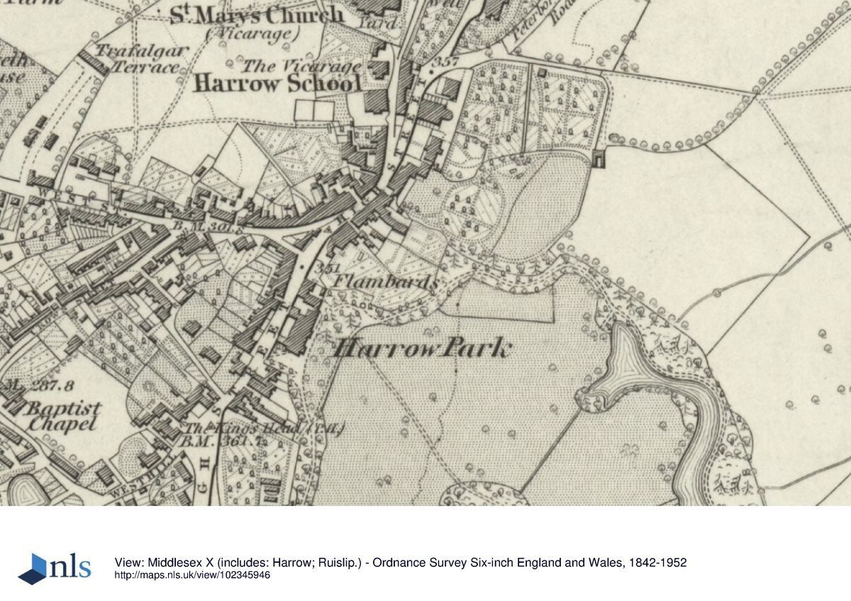
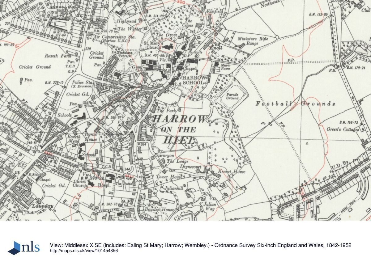
Harrow Park is situated in the 'village' of Harrow on the Hill which runs roughly north/south along a spine of high ground in the suburbs of west London. Wembley lies c 3km to the south-east, Kenton c 2km to the north-east, and Pinner a similar distance to the north-west.
The c 15ha site is bounded to the west by houses in the High Street and to the south and south-west by the gardens of houses in Harrow Park, a small road built, in part, along the line of the old perimeter drive; remains of the C18 brick boundary wall of the park survive to the south-west of the road. Buildings and playing fields of Harrow School provide the boundary to the north and east and part of the golf course, backed by open fields, the boundary to the south-east. The site falls steeply from the west with the lake lying in the lowest part near to the eastern boundary.
ENTRANCES AND APPROACHES
There is (1999) no public access to Harrow Park. The pupils and staff of Harrow School have access from the numerous properties they own along the west, north-west, and north boundaries. In addition there is private access to the golf course and sports facilities from Football Lane to the north and to the park from a private path midway along Harrow Park road.
There are no known maps of the grounds between Rocque's map of 1746 and the Enclosure award of 1803; consequently Brown's intended approach to the old house is not recorded. In the late 1820s (sale plan) the new house was approached from the south along a carriage drive which ran north, along high ground above the parkland, to the mansion. Immediately south of the mansion the drive divides, one branch passing to the south onto the High Street, the main branch continuing past the east front to proceed along the line of a perimeter drive around the lake.
PRINCIPAL BUILDING
The old mansion of Flambards, parts of which survived into the early C19, is thought to date back to the C14 (VCH 1971). It stood at the south end of the village of Harrow on the Hill approximately on the site of Nos 27-41 London Road. It was for this house that Lancelot Brown laid out his landscape and it was here that Henry Holland worked in c 1768. The new house designed by John Nash (1752-1835) for Richard Page and started in 1797, was built to the north of the old one on the highest point of the estate. When Lord Northwick bought the estate in c 1806 he employed John Shaw to add to the new house; by the time Northwick put the estate up for sale in 1823 the mansion was named Harrow Villa, but was subsequently known as Harrow Park; by 1897 it had acquired its current (1999) name, The Park. Since the mid 1820s further additions have been made to the mansion, particularly since the school acquired the site in 1831. In particular an extra storey was added c 1906. Built to an H-plan, the building (listed grade II) has thus been greatly altered but the late C18 stuccoed front with Diocletian window between two bays is still recognisable although much enlarged by north and south wings. The Coade stone lion relief, formerly above the east doorway and now on the south wing, dates from c 1806.
GARDENS AND PLEASURE GROUNDS
The gardens around the house were remodelled in the late C19. There is a grassed terrace off the east front of the house with fine views to the east across the park; a glacis runs down from the terrace to a formal rose garden (C20). Below the rose garden is a hedge and below this tennis courts. There is a bank running away from the house down the north side of the glacis and beyond this is a shrubbery.
PARK
From near the site of the old house, a private footpath from Harrow Park road leads down a steep path. After c 20m the path divides, the northern branch leading across an old orchard, below the gardens of Denecourt, a C19 red-brick house which occupies a commanding position on the corner of Harrow Park road; a C20 tennis court has been made to the east. This path continues north-east across the parkland, on what appears to be the route of a track recorded on C19 plans, towards the north end of the lake. The main path continues in an easterly direction, the land dropping away to the south-east. Scrub land rises steeply to the south above the path while a level area for sports has been made to the north. Some 100m along the path an area of woodland with a small pond has been developed as a nature reserve. The woodland, now mainly scrub but with a number of C19 horse chestnuts, probably developed from a rounded clump of trees, a dominant feature of the park from the early C19. The woodland, now (1999) enclosed within a chain-link fence, is entered by a small gate to the south-west. Between the path and the boundaries of the C19 and C20 houses in Harrow Park road are the remains of a 'drive' and although currently (1999) overgrown with scrub and ivy, elements of Brown's formal plantings survive along its line (Debois 1995). The Parochial Rate Assessment map (1852) shows a drive leading to a large building south-east of the clump of trees. This building appears on maps until c 1897. Some 20m to the east of the enclosed woodland the path divides, the north-east branch continuing across the golf course towards the north-west bank of the lake. The undulating ground is studded by trees, some of which are illustrated in Anne Rushout's paintings (Ball 1980). The southern path runs along the western boundary of the golf course with fine views north across the lake and to the north-east across grass fields to Northwick Park. After c 300m the path turns to the north-east and follows the perimeter walk around the narrow southern end of the lake.
The 2ha lake, first recorded in map form in 1803, was made by building a substantial dam, in places c 15m wide, with a steep fall below. The lake runs north-west for c 300m as a narrow serpentine, then widens out before terminating near to the north-east boundary of the park. The sale plan of c 1829 shows the lake bordered on the east side by woodland or shrubberies. The perimeter drive follows the line of the west bank of the lake, passing at a midway point the site of a rectangular building; this, according to map evidence, had been removed by the late 1880s. There is no available description of it but a painting (c 1803) by the artist George Barret junior (1762-1842) and dedicated to Richard Page, shows an ornamental tent on the lake's western bank (Ball 1980). The C19 plans show that the perimeter path crossed the eastern tip of the lake before continuing south-east along the boundary of the park.
The woodland along the east bank of the lake is made up of mixed trees including horse chestnut, yews, holm oak, beech, and a group of oaks below the dam and is typical of the planting found in many of Brown's pleasure grounds. The understorey contains a number of shrubs considered to be remnants of C18 or C19 plantings (Debois 1975). At the north-west end of the lake is a shrubbery with holly and thorn. From the perimeter path there are (in winter) good views back to The Park and Harrow church set on a high point to the north. The view to the brick gothic folly built onto the north-west boundary wall (in Harrow Park road), no longer exists. The sale plan of c 1829 suggests that the ruins were framed by planting so as to form an eyecatcher. Built to resemble a gothic tower, the folly is today (1999) in a more ruinous state than was originally intended. The perimeter path terminates at a car park and buildings associated with the school's sports facilities.
REFERENCES
D Lyson, The Environs of London ... Middlesex 2, (1810), p 374
W Keane, The Beauties of Middlesex (1850), pp 211-12
W W Druett, Harrow through the Ages (1956)
Victoria History of the County of Middlesex 4, (1971), pp 209-10, 229-30
D Stroud, Capability Brown (1975), p 225
Flambards, (Debois Landscape Survey Group 1975) [Report commissioned by EH as part of a survey of parks on the outskirts of London.]
A W Ball, Paintings, Prints and Drawings of Harrow on the Hill, 1562-1899 (1980)
B Cherry and N Pevsner, The Buildings of England: London 3 North-West (1991), p 269
Maps
J Rocque, London and the Country Ten miles round, 1746
Messeder, Plan of the Roads, Lanes, Commons, Greens and Waste of the Manor and Parish of Harrow on the Hill in the county of Middlesex, 1759 (Greater London Record Office)
Enclosure Award for Harrow, 1803 (Harrow Record Office)
Sale Plan, c 1828 (Harrow Record Office) [in Debois 1975]
Sale Plan, post 1829 (Harrow Record Office) [in Debois 1975]
Parochial Rate Assessment map, 1852 (in Debois 1975)
OS 1st edition 1" map published 1822
OS 6" to 1 mile:
1st edition published 1864
2nd edition published 1897
Description written: February 1999
Register Inspector: LCH
Edited: November 2001
- Visitor Access, Directions & Contacts
Directions
Nearest tube station - Harrow-on-the-Hill.
Owners
Harrow School
- History
The following is from the Register of Parks and Gardens of Special Historic Interest. For the most up-to-date Register entry, please visit the The National Heritage List for England (NHLE):
www.historicengland.org.uk/listing/the-list/
HISTORIC DEVELOPMENT
The old mansion of Flambards, or Flamberts as it was sometimes referred to as (VCH 1971), probably dated back to the C14. By 1664 Flambards was described as being the largest house in Harrow. It stood at the south end of the village of Harrow on the Hill surrounded principally, as recorded by John Rocque on his survey of 1746, by agricultural land. In 1767 the Flambards estate was sold to Francis Herne and a year later Lancelot Brown (1716-83) and Henry Holland (1745-1806) began work to improve both the house and landscape. Over the next three years they undertook work to the value of £12,000 (Ball 1980). After Herne's death the estate passed to his sister Mary, and in 1787 to Richard Page, the step-son of Hearne's sister Anne. Ten years later Page started work on a new house to the north of the old mansion. The Enclosure award of 1803 makes it clear that the basic structure of the C20 landscape was in place by that date. Details of the design is shown on various sale plans of the late 1820s.
In 1805 Page died and the house with c 35ha of land was sold to George Fleming of Hillingdon. Fleming never lived at the house and the estate was sold on to John Rushout, second Baron Northwick, who owned a great deal of land in the area. Although the sale was not completed until 1807, Lord Northwick lived there from 1805 and the architect John Shaw was undertaking alterations at the house in 1806-7. It would appear that Northwick also worked on the grounds, Lyson recording in 1810 that the pleasure grounds were much improved. John Rushout was a governor of Harrow School, which by this time was well established. Founded in 1572 under a charter from Elizabeth I, by the early C19 the 'Free Grammar School' had grown to dominate the town, and the boys were allowed to use the grounds of the new house for recreational purposes. Lord Northwick's daughter Anne was an accomplished water-colourist and a number of her paintings of Harrow Park survive (Ball 1980). By 1823 Lord Northwick had moved away and the house, referred to as Harrow Villa, and 23ha of land were put up for sale. In 1824 the estate was purchased by Archibald Campbell on behalf of Major General Alexander Mcgregor. In the same year, before the sale was completed, Mcgregor employed Decimus Burton to build Gothic Villas on part of the park (now Nos 7-17 London Road). By 1828 most of old Flambards house was gone.
In 1831 the Rev W W Phelps, an Harrow Master, bought Gothic Villas as a boarding house for the school and shortly after purchased the main house, the walled garden, a cottage, and part of the park (by now known as Harrow Park), for use by the School. In 1885 the Harrow Park Trust took over the freehold of the house and grounds from the Phelps family. This led to the development of the park for use by the school and many of the buildings in the area date from this period. From c 1897 (OS) the house was named The Park.
During the C20 much of the park was converted into a golf course and a small area set aside for a nature reserve. In the 1970s a number of houses to the south-west of the park were demolished to make way for a covered reservoir. The site continues (1999) to be owned and used by Harrow School for recreational and sports purposes, a large part of the park being managed by the school as a private golf course.
Period
- 18th Century (1701 to 1800)
- Late 18th Century (1767 to 1800)
- Associated People
- Features & Designations
Designations
Conservation Area
- Reference: Harrow Park/Harrow on the Hill Village
The National Heritage List for England: Register of Parks and Gardens
- Reference: 4179
- Grade: II
Site of Nature Conservation Importance
Features
- Lake
- Key Information
Type
Park
Purpose
Recreational/sport
Principal Building
Education
Period
18th Century (1701 to 1800)
Survival
Part: ground/below ground level remains
Hectares
15
- References
References
- {English Heritage Register of Parks and Gardens of Special Historic Interest} (Swindon: English Heritage 2008) [on CD-ROM] Historic England Register of Parks and Gardens of Special Historic Interest
- Pálsson, Gísli {Conservation Management Plan: Harrow Park} (2012) Conservation Management Plan: Harrow Park