
Introduction
Ham House has the remains of a 17th-century estate and gardens of around 12 hectares. The central gardens were restored to the late-17th-century form in 1975.
Terrain
The Ham House site lies on the south bank of the River Thames, upstream from Richmond.
The following is from the Register of Parks and Gardens of Special Historic Interest. For the most up-to-date Register entry, please visit the The National Heritage List for England (NHLE):
www.historicengland.org.uk/listing/the-list
Gardens and pleasure grounds attached to a 17th century house. The grounds were restored in late 17th century style in 1975-1976.
DESCRIPTION
Note: Ham House is orientated north-west/south-east but for the purpose of clarity in this description it has been assumed to lie north/south.
LOCATION, AREA, BOUNDARIES, LANDFORM, SETTING
The c 12ha Ham House site lies on the south bank of the River Thames, upstream from Richmond which lies to the north-east. Ham Street largely provides the boundary to the west, beyond which the West Avenue extends, with Ham Common to the south. Privately owned paddocks and a polo ground make up the east boundary. The pleasure grounds to the south of the House are enclosed on three sides by a high brick wall with three gateways, two on the east side and one on the south. The southern boundary wall (listed grade II) is pierced by wrought-iron gates c 1675/6 with the Tollemache coat of arms on the overthrow. The gates are hung from rusticated stone pillars (listed grade II) which open onto the South Avenue. Unfortunately the 1950s replanting of the initial part of the west side of this feature was not correctly aligned; however the important axis that runs centrally through Ham House and extends across Ham Common to the south-east is still apparent.
The fourth side of the pleasure grounds, to the north, is enclosed by a lower wall topped with iron railings. Stone piers are set at intervals along its length and these are topped with Coade stone pineapples. The gate, railings, and pineapples are all listed grade II. The ground outside the pleasure grounds is unfenced, being public open space.
ENTRANCES AND APPROACHES
Ham House is approached from the west along an avenue of mixed trees including limes, chestnuts, and planes. This approach is part of a considerably longer avenue of C17 origin which once extended to the west across the flood meadows of the River Thames and which was aligned to the east, across Petersham Meadow, on Richmond Hill. In front of the House, to the north, the avenue is intersected by a north/south avenue consisting mainly of limes which provides a view and access northwards, across the grass to the Thames and beyond to the grounds of Orleans House to the north, and Marble Hill (qv) to the north-east.
To the south this avenue leads through the north gateway (C17, listed grade II) into the forecourt, largely unaltered since the late C18 when the square, enclosed forecourt (illustrated by Smythson, 1609; Slezer and Wyke, 1671) was altered by the sixth Earl. At this time the north wall was taken down, the central path removed, and a turning circle created, partially enclosed with semicircular flanking walls inserted with niches containing classical heads and now (1997) fronted by bay trees trimmed to drums. The forecourt is dominated by the Coade stone river-god (John Bacon 1775, listed grade II), which is centrally sited between the entrance gates and the House. Beyond the statue the approach to the House continues with a flight of four stone steps providing access across a paved terrace flanked by panels of lawn, planted on the north side with pyramidal box and low box hedges and perennial plants. The entrance to the House is flanked by loggias at either side, known as The Cloisters.
Inside the main gate, on the south side, runs a wide gravel terrace, enclosed on the north side by C20 iron railings upon a brick wall which forms the edge of a ha-ha.
PRINCIPAL BUILDING
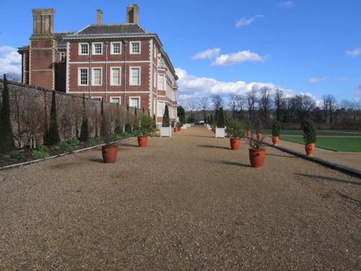
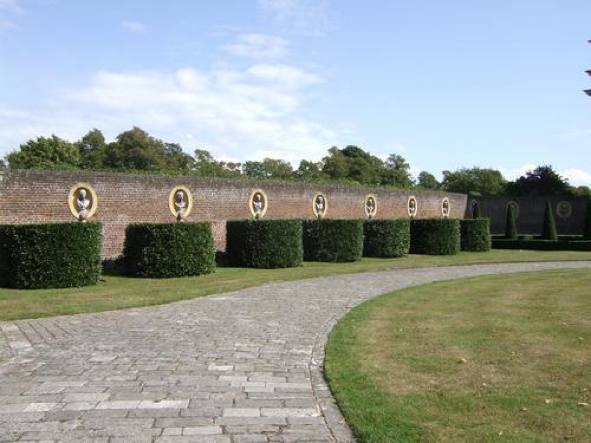
Ham House (listed grade I) was built 1609-10 for Sir Thomas Vavasour and extended and remodelled in 1672-4 for the Duke and Duchess of Lauderdale. A three-storey, brick-built house, the original H-plan was modified when the space between the wings on the south front was built over in the 1670s. A hipped roof and modillion cornice were substituted for the original gables. Full-height splayed bays were also added to the ends of the wings on the north front and niches with lead busts inserted c 1800 along this front at first-floor level.
The south, garden front, from which stairs lead down to ground level, overlooks the plats and the Wilderness. A door to the east opens onto the rear of the south terrace and a door to the west is approached through the west courtyard.
The stable block stands 150m south-west of the House, outside the area here registered.
GARDENS AND PLEASURE GROUNDS
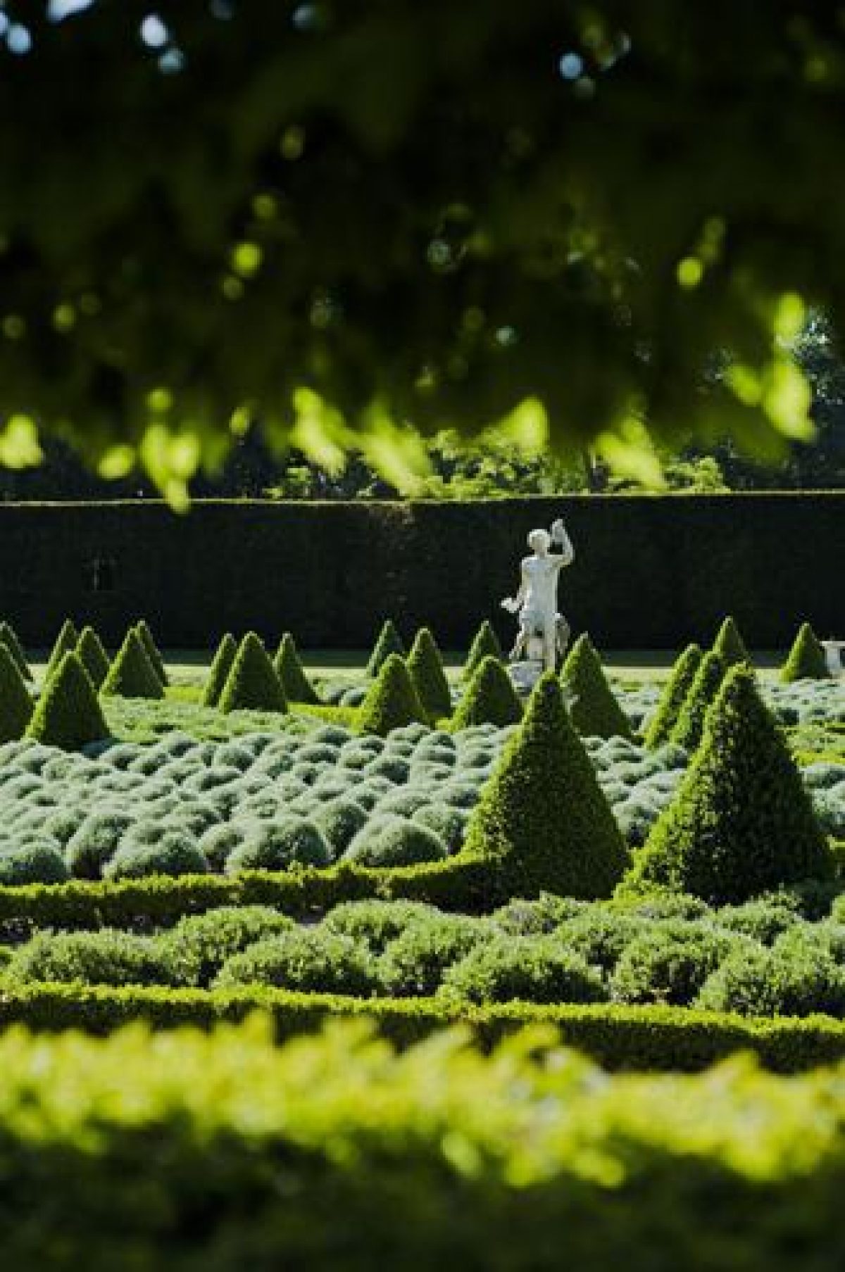
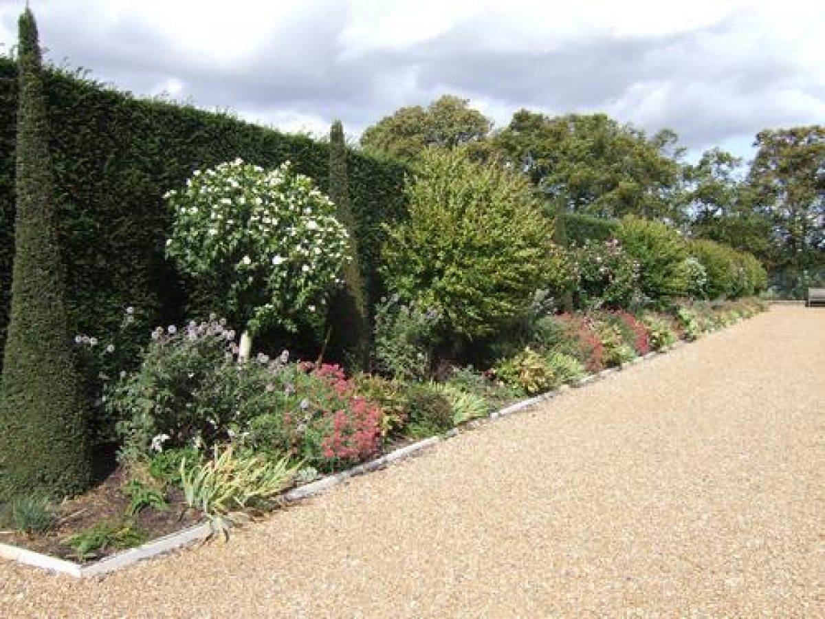
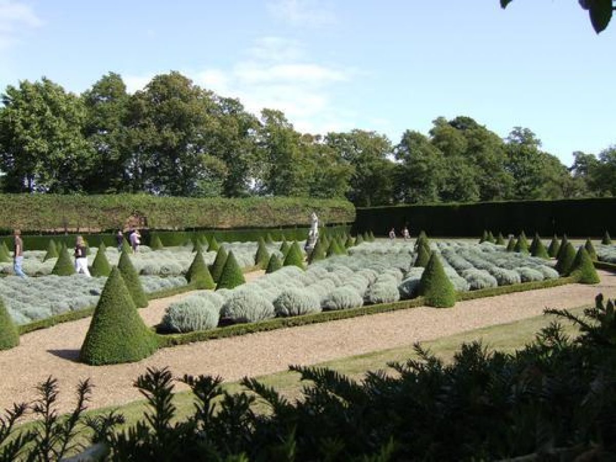
To the east of the forecourt on the north side of the House lies the Cherry Garden; it is not known why this name has been attached to the area. Robert Smythson's plan of 1609 identified it as the Principal Garden, but there are no design details included. The garden was replanted in 1975, a 1671 design by Slezer and Wyke (probably unexecuted) being used as a model. This plan shows a design of diamond-shaped beds and these have been executed in low box hedges with small pyramidal yews at intervals and at the corners. The shape is filled with either lavender or santolina and gravel paths separate the beds. Gravel paths and yew hedges enclose the Cherry Garden and hornbeam tunnel arbours to the east and west lead to the south terrace. The space between the western tunnel arbour and the rear of the eastern curved wall of the forecourt is made up as an herbaceous border. The Cherry Garden is screened from the south terrace along the south front of the House by tall yew hedges which are separated by a gravel path. The path leads from steps on the east side of the House to the east wall where, it is thought, there was a clairvoie out onto the Melancholy Walk.
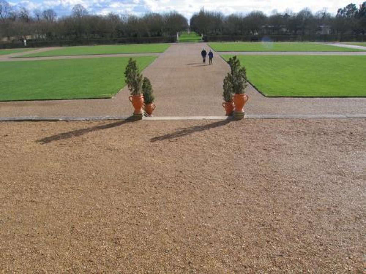
The gravelled south terrace, which runs between the east boundary wall and the wall of the Rose Garden to the west, is supported by a brick wall capped with coping stones topped at intervals with terracotta urns. The border below the terrace is planted out with herbs. Three flights of C19 steps lead south down to eight grass plats divided with gravel paths; these were reinstated during the 1975 restoration. Full-height iron railings, through which the Melancholy Walk and distant Richmond Hill can be viewed, pierce the boundary wall at the eastern end of the south terrace. To the north of the western end of the terrace, the south wall of the west courtyard provides the boundary, with herbaceous borders at the foot of it. Access to the west courtyard is through a doorway at the eastern end of this wall. Views extend south from the terrace across the plats to the Wilderness, and beyond along the main axial view to Ham Common in the south and the Melancholy Walk to the east.
A broad east/west gravel path separates the plats from the Wilderness to the south and joins up with the gravel paths that border the plats. A number of mature trees recorded on early editions of the OS map grow along the east and west edges of the grass plats.
The overgrown Wilderness was replanted in 1975 after the Slezer and Wyke design, which was also recorded on documents up to 1933. It is a geometric design of eight straight paths radiating from a central clearing, bisected by a single circular path. Consequently the Wilderness is divided into sixteen compartments which are planted with grass and naturalised bulbs and wild flowers, and screened off from the grass paths by hornbeam hedges with field maples planted at intervals. White wooden tubs with plants are set in the central area along with white wooden seats made to match the ones shown in a painting of the Wilderness executed by Henry Dankarts c 1675 (Mees 1993). Four small wooden huts (late C20) are also sited within the Wilderness; these are copied from a plan of Ham published in Vitruvius Britannicus c 1739.
To the west of the Wilderness and the plats, separated by a high brick wall and entered through tall iron gates hung on rusticated pillars topped with urns (listed grade II), is the Rose Garden. This area was first recorded as part of the Ham estate on the Slezer and Wyke plan c 1671 and was designated the kitchen garden on the Helmingham plan c 1730. The C18 orangery (listed grade II) standing at the north end, now (1997) the restaurant, bears a distinct resemblance to an orangery on the Vitruvius Britannicus plan of 1739.
The Rose Garden is not strictly rectangular: the west boundary wall cants slightly to the west and possibly reflects the enlargement of the area recorded on the OS 1st edition map of 1868. By 1897 (OS) the Rose Garden had been reduced in size and enclosed with a wall to the south. The Rose Garden now (1997) has peripheral gravel paths which meet up with the east /west path from between the plats and the Wilderness. This path, the Ilex Walk, continues the width of the garden and a statue base is set in the centre of the path half way between the gate and the west wall. A small yard for the gardeners is set in the south-west corner. The remaining part of this area is privately owned.
The grassed area to the north of the Ilex Walk is bordered to the east and west with beds containing roses. A mature horse chestnut survives to the south-east, and two ornamental trees enclosed within iron railings grow near the orangery. Field archaeology (see Mees 1993) and parchmarks reflect the buried remains of circular beds, and the sites of trees and paths recorded on the OS 1st edition map (1868). A connecting doorway is set in the northern end of the boundary wall, between the Rose Garden and the plats.
A further doorway, set in the wall to the east of the orangery, leads north to a grassed area which is bounded to the east by the west courtyard, giving access to the west front of the House, to the west by the stables (outside the area here registered), and to the south by the rear (north front) of the orangery. The grassed area is enclosed to the north by a high brick wall which is pierced at the eastern end by two brick piers which give access to the north terrace. Some 10m to the south of this entrance, set in the eastern boundary wall, is a brick icehouse (C19, listed grade II); 25m further south is the entrance to the west courtyard, and the west front of the House. The entrance is flanked by a pair of fine rusticated brick piers with Portland stone bases, cornices, and pineapples. Two late C17 lodges (listed grade II) stand on either side of the gateway; the one to the north is now the National Trust shop. The west courtyard is enclosed to the north and south with brick walls. A small doorway in the south wall gives access on to the south terrace and another in the north wall gives access to what is now (1997) called the orchard. Replanted in 1975 with a variety of fruit trees, the grassed area is shown on the Helmingham plan to have included an ornamental pond, remains of which were recovered during excavations in 1993 (Mees 1993) and have since been reburied.
OTHER LAND
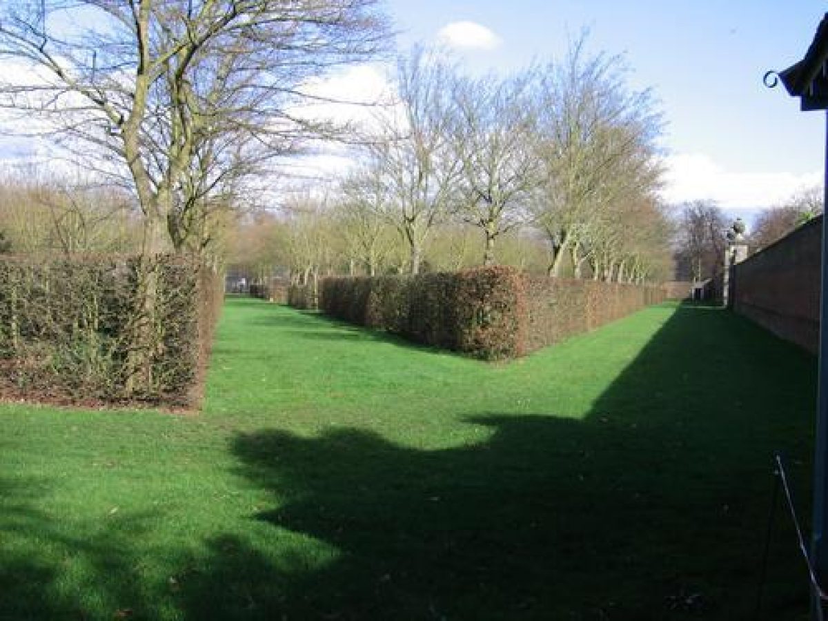
The ground beyond the brick walls of the pleasure grounds is largely laid to grass with the remnants of once extensive C17/C18 avenues still surviving. Adjacent to the east is the Melancholy Walk, a c 300m long path bordered by lime trees running north/south onto Ham Common. The South Avenue extends the north/south axis which runs through the House. The Avenue leads south for c 800m from the south boundary wall to twin gate lodges and beyond this for a further 350m across Ham Common. These brick cottages (listed grade II) possibly date from the early C17 (Mowl and Earnshaw 1985). The Melancholy Walk and the South Avenue are linked by a third, east avenue, which runs east from the north end of the South Avenue for c 700m to Petersham, where it terminates at an imposing brick-built arched gateway incorporating two flanking lodges (R D Oliver, 1900). On the east, entrance facade, above the archway, is a large coat of arms of the Tollemache/Dysart family.
John Rocque's survey of 1746 records a network of formal avenues aligned on the gardens of Ham House, providing it with grand vistas. The Melancholy Walk is shown on both the Slezer and Wyke plan of 1671 and Rocque's survey as being planted with multiple rows of trees.
REFERENCES
Note: There is a wealth of published material about this site. The reader is referred to R Desmond's Bibliography of British Gardens (1988) and the National Trust's 'Guide to Ham House'.
T Badeslade and J Rocque, Vitruvius Britannicus 4, (1739)
Richmond and Twickenham Times, 18 August 1900
T Mowl, Trumpet at a distant gate: lodges as prelude to the country house (1985), pp 19-21
D Mees, Ham House Historical Garden Report (1993)
Maps
Robert Smythson, Plan of Ham House, 1609 (reproduced in Mees 1993)
Attr John Slezer and Jan Wyke, Plan of House and Grounds, 1671 (reproduced in Mees 1993)
Plan of Ham House and Gardens, c 1730 (private collection)
Plan of Ham House and Gardens, published in Vitruvius Britannicus (1739)
J Rocque, Plan of the Cities of London and Westminster and Borough of Southwark and the country near ten miles around, surveyed 1741-1745, published 1746
OS 25" to 1 mile: 1st edition published 1868
2nd edition published 1897
Description written: April 1997
Amended: April 2001
Edited: November 2001
- Visitor Access, Directions & Contacts
Telephone
0844 800 1895Website
http://www.nationaltrust.org.ukAccess contact details
The gardens are open all year round between 11 and 6, except Thursdays and Fridays.
Directions
The site is on the Thames south bank, west of the A307. It can be accessed by car, train or bus, or on foot or bike.
Owners
The National Trust
PO Box 39, WA5 7WD
- History
The following is from the Register of Parks and Gardens of Special Historic Interest. For the most up-to-date Register entry, please visit the The National Heritage List for England (NHLE):
www.historicengland.org.uk/listing/the-list
HISTORIC DEVELOPMENT
Ham House was completed for Sir Thomas Vavasour in 1610. A plan made by Robert Smythson in 1609, before the House was completed, shows an H-shaped building with a garden laid out in a formal design and covering less ground than today (1997). William Murray, first Earl of Dysart lived at Ham from 1626 and his daughter Elizabeth, Countess of Dysart after him. Elizabeth's second marriage in 1672 was to the Earl of Lauderdale who soon after became Duke. It was from her first marriage (1647) to Sir Lyonel Tollemache (third Baronet) that were descended the subsequent earls of Dysart (and the baronetcy of Tollemache) who cared for the estate until 1948.
In the 1670s Ham House, used mainly as a summer residence, was enlarged and refurbished. A new south wing was built and the garden extended to the south. The Duke died in 1682 and his widow continued to live at Ham until her death in 1698 when the estate passed to her son, the third Earl of Dysart who, it would appear, took little interest in either the House or garden. His grandson, the fourth Earl of Dysart, inherited in 1727 and repaired the neglected House and is thought to have also refurbished the gardens. Attempts were made in the 1770s to naturalise the design of parts of the garden, when walls were removed and linear walks grassed over. By about 1800 the forecourt had been opened up but the remainder of the garden appears to have remained unaltered from about 1770. By the 19th century some elements of the fourth Earl's garden had been altered but the Wilderness survived. In the 20th century railings were erected along the line of the ha-ha to the north of the House.
In the early 20th century the property passed to Sir Lyonel Tollemache, Bt and Mr Cecil Tollemache who presented it to the National Trust in 1948. They in turn leased the House to the Ministry of Works (Department of the Environment) which maintained the building in close consultation with the Victoria and Albert Museum. In 1975 a large private donation enabled the National Trust to undertake a restoration of the gardens. In 1992 the Victoria and Albert Museum returned the House to the care of the National Trust. This initiated plans for restoration and refurbishment of the House as well as a new and thorough assessment of the historic gardens and pleasure grounds. Restoration work in the gardens is ongoing (1997).
- Associated People
- Features & Designations
Designations
The National Heritage List for England: Register of Parks and Gardens
- Reference: 1209
- Grade: II*
Style
Formal
Features
- Parterre
- Plat
- Summerhouse
- Orangery
- Avenue
- House (featured building)
- Description: Ham House was completed for Sir Thomas Vavasour in 1610.
- Earliest Date:
- Latest Date:
- Key Information
Type
Garden
Purpose
Ornamental
Principal Building
Domestic / Residential
Survival
Extant
Hectares
12
Open to the public
Yes
- References
References
- {English Heritage Register of Parks and Gardens of Special Historic Interest} (Swindon: English Heritage 2008) [on CD-ROM] Historic England Register of Parks and Gardens of Special Historic Interest
- Wilkie, Kim {Ham Avenues: Restoration Management Plan} (2001) Ham Avenues: Restoration Management Plan
- Eburne, Andrew {The gardens of Ham House: Conservation Management Plan} (2009) The gardens of Ham House: Conservation Management Plan
- Related Documents
-
CLS 1/403
Addendum chapter (typescript) for Garden CMP - Digital copy
Dominic Cole Landscape Architects - 2014
-
CLS 1/403