Introduction
Coopersale House has a small landscaped park occupying about 11 hectares, developed from about 1730 with possible input by Lancelot Brown in the later 18th century.
www.historicengland.org.uk/listing/the-list
C18 villa with landscape work of the early to mid C18 by Adam Holt; Lancelot Brown was consulted c 1774 but the extent of his involvement is not clear.
DESCRIPTION
LOCATION, AREA, BOUNDARIES, LANDFORM, SETTING
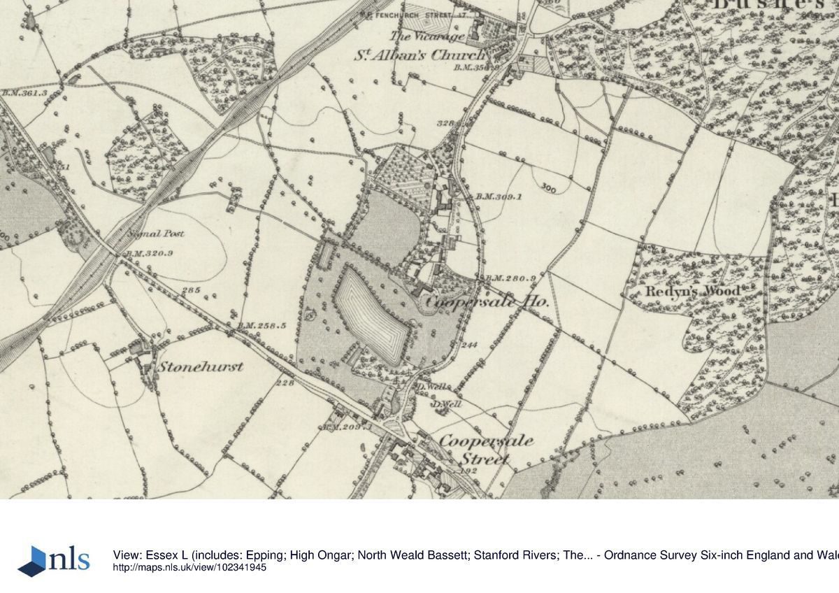
The c 11ha site lies to the west of the public road, Houblon Hill, which links the settlements of Coopersale 250m to the north, to Coopersale Street 100m to the south, the road forming the eastern boundary of the property. The southern boundary is defined by Stonards Hill/Coopersale Road, the public road joining Coopersale Street with Epping 1km to the north-west.
To the west and north the grounds merge with arable farmland, the wider setting to east and south also being agricultural.
ENTRANCES AND APPROACHES
The main drive leads south-west off Houblon Hill, through wooded shrubbery to the turning circle below the east front of the House. From the same entrance point, a back drive leads to the outbuildings and farm (outside the area here registered).
The south entrance, which continued the line of the public road north from Coopersale Street, is no longer in use. The public road now swings eastwards at this point, the House and associated buildings marking its former line. It was moved eastwards to its present position following authorisation of the diversion in 1770, around the time that Brown visited the site.
PRINCIPAL BUILDING
Coopersale House (listed grade II) stands east of centre of its grounds. Dating from the C17, it is mainly of C18 date, the upper of the original three storeys being removed in 1920. To the north stands a small complex of outbuildings. At the northern tip of the site, c 150m from the House, stand the buildings of the home farm, Coopersale Farm.
GARDENS AND PLEASURE GROUNDS
From the turning circle the ground falls eastwards as rough grass to the line of the road. This area has been worked to form a valley (Debois 1995), the raised east bank of which carries the eye over the surface of the public lane (now divided from the bank by a hedge). Long views extend out towards Hill Hall (qv); the views south are across the falling ground to the lake, c 60m from the House, which forms the dominant feature in the grounds.
A walk leads south from the narrow terrace (early C20) which lies below the south front, following the line of the old road southwards to the lake. From here it continues across the substantial dam which retains the water along the east and south sides. Partway along the eastern bank stands a pair of gate piers, beyond which is an area of woodland which forms the backdrop to the walk. To the north-west of the main lake is a smaller pond, planted up in the early C20 as a Japanese garden. A walk leads eastwards from here back up to the House; along its route are the earthwork remains of C20 additions to the grounds including a tennis court and lawn.
The main circuit walk continues from the pond northwards to the kitchen garden. Ditched to either side, it passes through mature shrubbery plantings, the ditches separating the path from, to the west the parkland, and to the east the paddock which occupies a c 2ha area above and to the north-west of the House. Dividing this open grass area from the kitchen garden to the north is a band of shrubbery, notable trees above the evergreen understorey including cedar of Lebanon and holm oak.
PARK
To the west of the pleasure grounds lie arable fields scattered with specimen oaks, visually terminated to the west by the wooded belt marking the line of a railway. The former park appears to have extended westwards beyond this to the line of the current (1997) public footpath, thus taking in two blocks of woodland. Andrews and Drury's map of 1807 however shows no parkland beyond that just west of the lake, this also being the position as shown on the 1st edition OS map surveyed 1873-4. Although the area is outside that here registered, it remains an important part of the setting of the pleasure grounds.
KITCHEN GARDEN
The c 0.75ha kitchen garden, which occupies the north-west corner of the site to the west of the farm, is a brick-walled enclosure. A plan for the 'new kitchen garden' survives (Houblon-Archer archive), dated 1758, the kitchen garden prior to this having been contained within two long thin triangles of land to the north of the lake.
REFERENCES
P Morant, The History and Antiquities of the County of Essex (1763-8), p 160
P Muilman, A New and Complete History of Essex III, (1770), p 404
Gentleman's Magazine LXX, (1801); LXXI, (1801)
J C Loudon, Encyclopaedia of Gardening (1822)
T Wright, History of Essex (1836), p 377
Victoria History of the County of Essex IV, (1956), p 269
D Stroud, Capability Brown (1975), p 221
Coopersale: A Survey of the Landscape, (Debois Landscape Survey Group 1995)
Garden History 26, no 2 (Winter 1998), pp 214-17
Maps
Watercolour plan for improvements to ponds, 1738 (D/EAH 6199/21), (Berkshire Record Office)
Samuel Woolmer, The Plan of the New Kitchen Garden, 1758 (D/EAH), (Berkshire Record Office)
Faden, Map of Essex, 1790
A Boundary Survey Round the Mansion House of John Archer, June 1773 (D/EAH), (Berkshire Record Office)
J Chapman and P Andre, A map of the county of Essex from an actual survey ..., 1777 (Essex Record Office)
J Andrews and A Drury, A Map of the County Sixty-five Miles round London from Actual Surveys, 22 January 1807
C and J Greenwood, Map of the County of Essex from an Actual Survey made in the Year 1824, published 1825
Tithe map for Theydon Garner parish, 1838
OS Surveyor's drawings, 1799 (British Library)
OS 6" to 1 mile: 1st edition surveyed 1873-4
OS 25" to 1 mile: 1st edition surveyed 1872
Archival items
Archer papers (mostly 1725(50), (D/DU 363/4), (Essex Record Office)
Archer archive (Berkshire Record Office)
Description written: September 1998
Amended: February 1999
Register Inspector: HJ
Edited: April 2001
- Visitor Access, Directions & Contacts
- History
The following is from the Register of Parks and Gardens of Special Historic Interest. For the most up-to-date Register entry, please visit the The National Heritage List for England (NHLE):
www.historicengland.org.uk/listing/the-list
HISTORIC DEVELOPMENT
Coopersale House was built at the end of the C17 by John Archer, whose family was established in the parish by the late C16. Archer died without issue in 1707 and left the estate to a colleague, William Eyre, on the condition he marry into the family and change his name to Archer. In the later 1730s, William called in Adam Holt, gardener at Wanstead Park (qv), to carry out an extensive scheme of landscaping for which detailed records survive. The accounts refer to work on shaping the pond, to the forming of levelled walks, to improving the contours, making a 'counter walk' 5' (c 1.5m) wide, and preparing the 'Grand Terrass' for turfing or seeding, for which Holt was paid a total of £260 (Archer papers). A letter from Holt to Archer of 30 September 1738 refers to, amongst other work, 'Carting of Clay for ye great slope next the town in ye Avuney', and 'Louvelling all ye Holes under the Great trees next ye upper Stew pond'.
Following the death of his wife Eleanor, William married secondly, Mary, daughter of Earl Fitzwilliam (d 1776), their son John inheriting the Coopersale estate in 1739. Lancelot Brown's account books of around or before 1774 indicate receipt of payment of £36 15s 0d '& all Demands' from 'Archer, Coopersale' for 'journeys and Plans'. Around 1780, John Archer, a wealthy landowner with property in Essex and Berkshire, ordered Coopersale to be shut up to save taxes, but the house had apparently already been deserted for 'twenty years or more' (Gentleman's Mag 1801) which casts doubt on the likelihood of any of Brown's proposals having been carried out. Chapman and Andre's map of 1777 and the OS Drawing of 1799 both show the lake in extended form, with an arm leading northwards from its western end. The Tithe map of 1838 however, and all later maps, records the shape of the water as being the same as that shown on the 1738 plan.
John Archer's daughter, Susanna (d 1837), who married Jacob Houblon of Hallingbury (d 1783), returned to live at Coopersale on the death of her father in 1800. In 1836 the estate became the home of Mrs Houblon Newton, 'representative of the Archer family' (Wright 1836), J C Loudon referring to the property as 'a spacious edifice, surrounded by lawns and pleasure grounds' in the villas section for Essex of his Encyclopaedia (1822).
The House was lived in successively by various females of the family until being sold in 1914, since when it has passed through a number of hands. The estate remains (1999) in private ownership.
- Associated People
- Features & Designations
Designations
The National Heritage List for England: Register of Parks and Gardens
- Reference: 4617
- Grade: II
Features
- House (featured building)
- Earliest Date:
- Latest Date:
- Key Information
Type
Park
Purpose
Ornamental
Principal Building
Domestic / Residential
Survival
Extant
Hectares
11
Civil Parish
Epping
- References
References
- Stroud, D {Capability Brown} (1975) p 221 Capability Brown (Country Life article)
- {English Heritage Register of Parks and Gardens of Special Historic Interest} (Swindon: English Heritage 2008) [on CD-ROM] Historic England Register of Parks and Gardens of Special Historic Interest