Introduction
Compton Place has a 19th-century formal garden featuring wooded grounds and circular lawn. There are also surviving 18th-century elements. The site occupies about 10 hectares.
Terrain
The site lies at the east end of a shallow, north-east-facing valley. The house occupies the level valley floor with the land rising gently to the near horizon on its north side but much more steeply and quickly on its south-west side.www.historicengland.org.uk/listing/the-list
A garden with elements surviving from the C18 with which Charles Bridgeman and Lancelot Brown are associated and for which Humphry Repton prepared apparently unexecuted proposals in a Red Book, and with additional C19 formal features.
DESCRIPTION
LOCATION, AREA, BOUNDARIES, LANDFORM, SETTING
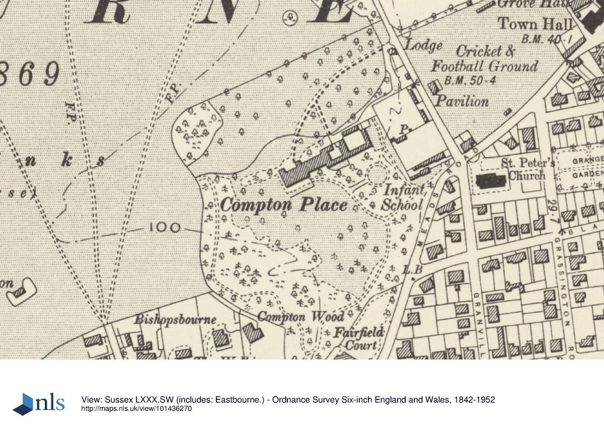
Compton Place is situated on the western fringe of Eastbourne, just to the south of the Old Town and the A259, and c 1km inland from the coast. To the north and west, its boundaries open immediately onto the Royal Eastbourne Golf Club course and are defined by a flint-walled ha-ha, probably of early C18 origin and possibly part of Bridgeman's work. To the south, a concrete and pebble-faced wall marks the C20 boundary with the housing development of Saffrons Park, begun on land sold in 1983. A block of flats, Saffrons Court, separates the registered site from Compton Place Road which runs the length of the eastern boundary. In 1782, the road which then formed the site's eastern boundary, known as the Way to the Bourne, was diverted eastwards to the course of the present Compton Place Road to unite the detached walled garden with the remainder of the grounds (estate survey dated 1739).
The c 9.9ha site lies at the east end of a shallow, north-east-facing valley, which is enclosed by the lowest slopes of the South Downs where they drop steeply towards the south-west side of the town from Beachy Head. The house occupies the level valley floor with the land rising gently to the near horizon on its north side but much more steeply and quickly on its south-west side.
ENTRANCES AND APPROACHES
The site has one main entrance, from Compton Place Road. This seems to have been established after this road was diverted eastwards in 1782. The original north to south line of the road can be seen on the estate map of 1739 and also on a plan (of the Hundred and Parish of Eastbourne) dated 1783. Before the road was moved, the entrance to the estate appears to have been further south and associated with the Elizabethan house.
Except along the frontage of the estate office, a high flint boundary wall encloses the site along Compton Place Road, with a convex wing of dressed flint wall defining each side of the entrance. Inside to the south is a single-storey, flint-fronted lodge, shown in existence on the Tithe map of c 1841. The drive sweeps in a wide arc westwards and then southwards across the lawns to the house.
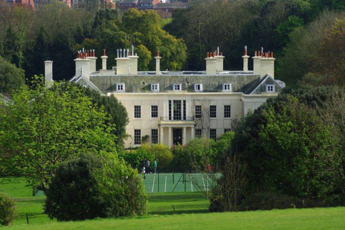
PRINCIPAL BUILDING
The present house, offices and courtyard stable block (listed grade I) form an east to west range of buildings in the centre of the site. Sophia Burrell's water colours of 1783 show open views from the house south-eastwards to the coast at Sea Houses and north to downland windmills which are now obscured by woodland and development.
Little evidence exists of the detailed layout of the Elizabethan house built in 1544 and incorporated into the present house. Its entrance was on the north front, through a courtyard formed by projecting wings. In 1726, Colen Campbell extensively remodelled and refaced the house but retained the E-shaped plan and a north entrance point. New kitchens and a brew house were built to the east of the house but the proximity, then, of the boundary of the grounds to the route of the public road prior to its diversion in 1782, suggests a later date for the construction of the extreme eastern stable and coach-house court.
During the ownership of Lord George Cavendish, (from 1782 until 1843), the house was given its present, stuccoed, Regency appearance, including the Doric colonnade to the south porch. The eastern kitchen and stable blocks were also altered and added to.
GARDENS AND PLEASURE GROUNDS
The house has small formal gardens on its west and south sides. The southern terrace, running the length of the house and edged by a stone plinth, was laid out in the early C19 by Lord George Cavendish. Rose beds are cut into the grass surface of the terrace. At the west end is a further garden with formal beds which were laid out after 1930, surrounded by a flint retaining wall and enclosed by trees and shrubbery.
South and west of the terrace are open lawns, dotted with a few single trees. The lawn rises steeply to the south-west, forming a glade within the woodland edge at the top of the slope. The woodland now contains few of the mature trees shown established on the OS 1st edition map surveyed 1873-5. It forms a wide belt around the south-west boundary, screening the house from external view. Within it is a short length of a hollow-way, running from east to west and marking the boundary of the grounds in the early C18. The land now occupied by the late C20 Saffrons Park development was added and planted as woodland in the mid or late C18 and early C19 and contained meandering walks.
From the eastern end of the terrace, a gravelled path curves south-eastwards across the lawn. To its east, enclosed within a grove of beech, holm oak and chestnut, and approached by a path lined with five pairs of stone plinths, is a circular, open lawn with a central mound and circular, metalwork rose arbour. The present ground plan of this feature has been in existence since at least the mid C19; it appears to have developed from the layout of the land prior to its incorporation into the estate after the road diversion in 1782 (estate survey, 1739; estate map, 1803).
North of the rose arbour grove, a path runs northwards between the stable block and the kitchen garden wall. Built against the eastern wall of the stable block is a small, rustic bothy, faced with unpeeled timber and with gothic windows. It is shown on the OS 1st edition and is now used as a gardener's store.
On its north side, the house opens onto a gravelled forecourt and a small lawn. The vista is limited to the near horizon of the golf links, just beyond the boundary ha-ha. A serpentine, iron paling fence, shown established on this line on the OS 1st edition, separates the whole building range and southern gardens from the grounds to the north. The present drive was in existence by 1845, as was its link southwards to the coach house and stable block; map evidence suggests that the link follows a section of the route of the Way to Bourne before its diversion in 1782. The northern grounds are laid out to lawn, lightly dotted with trees, a few of which survive from the denser planting shown in 1873-5.
To the north-west of the house, beyond a tennis court, the surrounding woodland belt encloses the grounds from vistas westwards. An opening in the belt was created between 1845 and 1875 but this had grown or been planted over by the early C20. The opening would have given a view to the folly, known as the Paradise Belvedere, sited 650m away on the western edge of the golf links. The flint-faced folly has a central pedimented arch and two wings with arched niches. A folly of stone seems to have been erected on the orders of Lord Wilmington in c 1740, to replace a previous timber structure on the same site (Compton estate archives) but it is unclear if the present folly is that erected by him.
KITCHEN GARDEN
The high, part brick and part flint north and west walls of the kitchen garden form part of the present eastern boundary of the estate. The garden was separated from the main grounds by the Way to Bourne before its diversion eastwards in 1782. An estate map of 1803 and William Figg's map of 1816 appear to indicate that the garden was more extensive to both the north and west than the double cube shown on the Tithe map of c 1841. Saffrons Court was built over the garden in 1963.
REFERENCES
H Pechell, A Complete History of Sussex (vol 5 of the Magna Britannia and Hibernica, 1730, with notes and additions by Sir William Burrell between 1730 and 1796)
E M and E Hopkins, The Guide to Eastbourne (c 1845), p 22
G F Chambers, Eastbourne Memories (1864), pp 16-18, 36
W Budgen, Old Eastbourne (1912), appendix A, p 339
Country Life, 40 (2 September 1916), pp 266-73; (9 September 1916), pp 294-303; 77 (9 February 1935), pp 144-50; 113 (13 March 1953), pp 734-7; (20 March 1953), pp 818-21
C Hussey, English Country Houses: Early Georgian (1955), pp 87-96
I Nairn and N Pevsner, The Buildings of England: Sussex (1965), p 485
P Willis, Charles Bridgeman and the English Landscape Garden (1977), pp 61-2
D Robert Ellaray, Eastbourne, a Pictorial History (1978), entries 29, 30
Garden History 17, no 2 (1989), p171
Maps
Eastbourne Hundred ... in the Year 1552 (Eastbourne Borough Library)
A survey of the Compton Estate, 1739 (Compton Place Archives, Chatsworth)
Plan of the Hundred and Parish of Eastbourne ... based on Yeakell and Gardner's Map of 1783 and other Surveys, c 1783 (Eastbourne Borough Library)
Estate plan, c 1803 (Compton Place Archives, Chatsworth)
William Figg, A map of the Parish of East-bourn in the County of Sussex, 1":352", 1816 (East Sussex Record Office)
William Figg, Plan of the Parish of Eastbourne in the County of Sussex, 1":396', 1845 (East Sussex Record Office)
Tithe map of Eastbourne, c 1841 (East Sussex Record Office)
OS 1st edition Old Series, 1" to 1 mile, surveyed 1793-6
OS 6" to 1 mile:
1st edition surveyed 1873-5, published 1879
2nd edition published 1900
3rd edition published 1910
4th edition published 1930
5th edition published 1938
OS 25" to 1 mile:
1st edition published 1876
2nd edition published 1899
3rd edition published 1910
4th edition published 1925
1960 edition
1995 edition
Illustrations
S H Grimm, Bourne Place, otherwise Compton Place, 1783 (Burrell Collection, British Museum)
S Burrell, View of Sea Houses at Southbourne, taken by S Burrell from Lady Elizabeth Compton's Gardens, 1781 (Magna Britannia)
S Burrell, View of the Mill above Lady Betty Compton's, taken by S Burrell from a Field behind the House, late Sir John Dyke's at Southbourne, 1781 (Magna Britannia)
View of north elevation of the house, signed S B, dated 1781 (Magna Britannia)
Archival items
Compton Place Archives ,Deeds and Documents belonging to His Grace the Duke of Devonshire at Compton Place... The above index to the archive [copy at Eastbourne Library, E 942.25] lists items from early charters relating to the Burton family, plans, surveys, designs, stewards' accounts and garden accounts etc, for the Compton and Cavendish periods, the material being stored at Chatsworth House. Repton's Red Book is also kept at Chatsworth, with photographic copies of a number of pages and illustrations at the Towner Art Gallery, Eastbourne Borough Council.
Description written: December 1996
Amended: July 1997
Register Inspector: VCH
Edited: March 2000
- Visitor Access, Directions & Contacts
Directions
On the west side of Eastbourne Old Town
- History
The following is from the Register of Parks and Gardens of Special Historic Interest. For the most up-to-date Register entry, please visit the The National Heritage List for England (NHLE):
www.historicengland.org.uk/listing/the-list
HISTORIC DEVELOPMENT
Part of the Lordship of medieval Eastbourne, the manor known as Eastbourne Place was acquired by James Burton in 1544. He changed its name to Bourne Place and was the likely builder of the Elizabethan house which became incorporated into the present mansion. The property passed by marriage in 1644 to the Wilson family who farmed the estate before letting it, in 1718, to Spencer Compton, younger son of the third Earl of Northampton. He purchased it in 1724 and, through his acquaintance with Lord Burlington, commissioned Colen Campbell (1676-1729) to enlarge and remodel the house which he renamed Compton Place. Charles Bridgeman (d 1738) is recorded as working on the site between 1728 and 1738 (Willis 1977). Spencer Compton, ennobled as Lord Wilmington, then later as Viscount Pevensey, died in 1743 and in 1766 a payment was made to Lancelot Brown (1716-83), for unknown works 'relative to the late Earl of Northampton' (Chatsworth papers). The house and its grounds passed by the marriage in 1782 of Lady Elizabeth Compton to Lord George Cavendish, son of the fourth Duke of Devonshire. In the late C18 the grounds were extended by the incorporation of land to the east and south, Humphry Repton (1752-1818) being invited by Lord Cavendish to advise on the landscape. He produced a Red Book in 1803 but his proposals were not, apparently, adopted. Lord Cavendish died in 1843 and by the mid C19 the grounds had reached their maximum size, through further small extensions to the south-west.
Residential development had begun by 1899 with the building of Fairfield Court on the southern, Meads Road, frontage. The Saffrons Court flats were built on the Compton Place road frontage in 1963 and the housing development of Saffrons Park was begun in 1987/8. The tenth Duke of Devonshire died in 1950. In 1954, Compton Place was leased as its present use as an educational establishment.
- Associated People
- Features & Designations
Designations
The National Heritage List for England: Register of Parks and Gardens
- Reference: GD1726
- Grade: II
Features
- Lawn
- Mansion House (featured building)
- Description: The Elizabethan house has been incorporated into the present mansion.
- Earliest Date:
- Latest Date:
- Ha-ha
- Description: Flint-walled ha-ha, probably of early 18th century origin.
- Earliest Date:
- Latest Date:
- Boundary Wall
- Description: To the south, a concrete and pebble-faced wall marks the 20th century boundary.
- Earliest Date:
- Latest Date:
- Formal garden
- Woodland
- Key Information
Type
Garden
Purpose
Ornamental
Principal Building
Education
Survival
Extant
Hectares
9.9
Open to the public
Yes
- References
References
- {English Heritage Register of Parks and Gardens of Special Historic Interest} (Swindon: English Heritage 2008) [on CD-ROM] Historic England Register of Parks and Gardens of Special Historic Interest
- Nairn, I and Pevsner, N {The Buildings of England: Sussex} (Harmondsworth: Penguin, 1965) p 485 The Buildings of England: Sussex