Introduction
Broomfield Park is an early-20th-century public park. It incorporates gardens laid out in the early-18th century to complement the house. The house is now derelict, following a fire. There are two lakes, a boating lake, a bowling green, a children's play area, a sports pitch, a green house and the remains of a walled garden.
Terrain
The site is on level ground and is set within a largely residential area of Enfield.The following is from the Register of Parks and Gardens of Special Historic Interest. For the most up-to-date Register entry, please visit The National Heritage List for England (NHLE):
Early 18th century gardens set in a park and associated with a mansion. Converted for use as a public park in 1903.
Location, Area, Boundaries, Landform and Setting
Broomfield House stands towards the south-east of the 21ha site, with the gardens and park lying to the west. The site is on level ground and is set within a largely residential area of Enfield between Arnos Park to the west and Palmer's Green to the north-east. The park is bounded by Alderman's Hill (A1004) to the north, Powys Lane to the west (B1452), Broomfield Avenue beyond a row of houses to the east, and Broomfield Lane bordering the southern edge of the park. The south-east boundary is marked by C16 to C18 brick walls (listed grade II) and there are park railings along the south-west, west and north sides.
Entrances and Approaches
The main approach to the House is from Broomfield Lane from where a drive leads west to the south side of the House. There are further entrances into the gardens and park from the surrounding roads on all sides.
Principal Building
Broomfield House (listed grade II*) originates from a C16, two-storey, timber-framed farmhouse, which was gradually expanded and altered through the C17, C18 and C19. The remaining exterior is largely C19 but with fake timberwork added by the Council in 1928-32. The fires damaged a staircase and a series of early C18 murals by Gerald Lanscroon, currently (1999) in store and awaiting restoration.
The early C18 rectangular stable block stands to the south of the House, currently (1999) empty. The stable court is enclosed by high, early C18 brick walls.
Gardens and Pleasure Grounds
A chain of four formal ponds runs north/south across the site to the west of the House. The southern three are rectangular and are depicted on the C18 maps (Rocque, 1754). A half-timbered bandstand of 1926 stands on the west side of the southernmost pond. The three southern ponds lie, along with the House, within a walled enclosure, the walls of which date from the C16 to C18 (west, south and inner walls listed grade II, east wall listed grade II*). The bowed north wall has been demolished. A gateway breaks the west wall at a point opposite the west front of the House, on either side of which are openings in the brickwork, now infilled with modern railings. These may have been early features, serving as clairvoies. An early C18 pavilion (listed grade II*) is built into the eastern wall, south of which is a gateway into Broomfield Lane.
The fourth and northernmost pond lies outside the walled enclosure. It is oval in shape and was an early C20 addition. A shelter stands at its northern end. To the east of the oval pond is a garden area with a children's playground beyond.
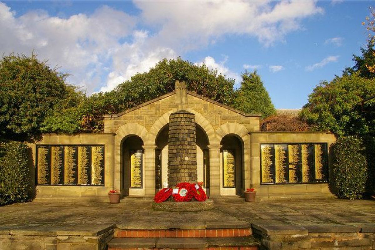
Garden of Remembrance
In the south-east corner of the gardens, lying between the stables and outbuildings to the north and the Broomfield Lane boundary to the south-east, is a walled Garden of Remembrance designed by the Borough Architect and Surveyor, R Phillips, and opened in 1929. An arcaded temple is flanked by pergolas, with a memorial cairn in front.
This walled memorial garden contains a small temple, in front of which is a cairn of stones. Each stone represents a life lost in war, and originally there were 280. Three small windows in the temple celebrate sacrifice, victory and fortitude. The entrance gates were presented in honour of Frank Barratt. This garden commemorates the soldiers who died in both World Wars, and the civilians who lost their lives in World War 2. The garden was opened on July 7th, 1929. The gates and memorial plaques have previously been stolen and replaced.
Park
To the west of the walled gardens is an area of open parkland, crossed by a double avenue extending north-west from the centre of the west wall of the gardens. The avenue now consists of lime trees, which were planted in the late C20 along the line of a double elm avenue shown on mid C18 plans. The north-east quarter of the park is occupied by a number of tennis courts and two bowling greens (on the northern boundary of the park), which were laid out from the early C20 onwards.
To the east of the gardens, the entire eastern side of the park is occupied by a sports ground.
Maps
- Estate map, 1599 (Enfield Local History Unit)
- J Rocque, Map of Middlesex, 1754
- Southgate Enclosure map (Enfield Local History Unit)
- OS 25" to 1 mile: 1st edition published 1865
- 2nd edition published 1896
- 3rd edition published 1914
- 1936 edition
Description written: March 1999
Edited: May 2000
- Visitor Access, Directions & Contacts
Access contact details
The park is open from 8am Mon-Sat / 8.30am Sundays to dusk (refer to Council website for seasonal details).
Directions
Rail: Palmers Green. Bus: 121, W6, 329
Owners
London Borough of Enfield
- History
The following is from the Register of Parks and Gardens of Special Historic Interest. For the most up-to-date Register entry, please visit The National Heritage List for England (NHLE):
16th - 17th Century
The house was built in the 16th century and is shown on an estate map of 1599 (Enfield Local History Unit), at which time it was owned by Geoffrey Walkaden. By the end of Elizabeth I's reign, it was the property of Alderman Sir John Spencer, who sold it to Joseph Jackson, a City merchant (in possession by 1624). Rocque's map of Middlesex, 1754, shows the park with its present boundaries, a series of ponds and an avenue.
18th - 20th Century
In 1773, Mary Jackson received the property as part of her dowry on her marriage to William Tash. Mary Tash's will, dated 1811, left the property to Louise Powys and her husband Henry Phillip Powys, of Hardwick House, Bucks. The Powys family lived at Broomfield until 1858 and it was then leased out until 1902, when the freehold was sold to Southgate Urban District Council.
The House and park were opened to the public in 1903. T H Mawson (1861-1933) advised on adapting the grounds to public use and his plan for Broomfield was published in his book Civic Art but few of his recommendations were implemented. The House was subsequently used as a school, a health centre, a café and a museum.
The House was gutted by fires in 1984, 1993 and 1994 and is currently (2024) unoccupied.
In 2003 Broomfield House was featured on the BBC television series Restoration as a nominee for the south-east segment of the show. It unfortunately lost out to London's Wilton's Music Hall. However, further funding applications have been submitted by Enfield Council to 'memorialise' Broomfield House and upgrade other areas, have won first stage National Heritage Lottery Funding. More information can be found on the 'restoring Broomfield house for the community' website.
Period
- 20th Century (1901 to 2000)
- Early 20th Century (1901 to 1932)
- Associated People
- Features & Designations
Designations
The National Heritage List for England: Register of Parks and Gardens
- Reference: GD1496
- Grade: II
The National Heritage List for England: Listed Building
- Reference: Broomfield House; remains of C16-18th east wall with attached early C18th pavilion/garden house & stableblock.
- Grade: II*
The National Heritage List for England: Listed Building
- Reference: remains of C16th-C18th west, south and north walls of Broomfield House enclosing ponds
- Grade: II
Plant Environment
- Environment
- Water Garden
Style
Formal
Features
- Ornamental Pond
- House (featured building)
- Now Derelict
- Description: The house was built in the 16th century and is shown on an estate map of 1599.
- Latest Date:
- Boundary Wall
- Description: The south-east boundary is marked by 16th to 18th century brick walls (Listed Grade II)
- Railings
- Description: There are park railings along the south-west, west and north sides.
- Key Information
Type
Park
Purpose
Recreational/sport
Plant Environment
Environment
Principal Building
Parks, Gardens And Urban Spaces
Period
20th Century (1901 to 2000)
Survival
Extant
Hectares
21
Open to the public
Yes
- References
References
- {English Heritage Register of Parks and Gardens of Special Historic Interest} (Swindon: English Heritage 2008) [on CD-ROM] Historic England Register of Parks and Gardens of Special Historic Interest
- Cherry, B. and Pevsner, N. {The Buildings of England: London 4: North} (London: Penguin, 1998) pp 461-462 The Buildings of England: London 4: North
- Mawson, T H., (1911), fig 168 Civic Art: Studies in Town Planning, Parks, Boulevards and Open Spaces
Contributors
London Parks and Gardens Trust
- Related Documents
-
CLS 1/982/1
Restoration of an Historic Public Park, Vol.1 Survey and Analysis - Hard Copy
Parklands Consortium - 1997
-
CLS 1/982/2
Restoration of an Historic Public Park, Vol.2 Conclusions and Recommendations - Hard Copy
Parklands Consortium - 1997
-
CLS 1/982/3
Restoration of an Historic Public Park, Vol.3 Appendices - Hard Copy
Parklands Consortium - 1997
-
CLS 1/982/4
Reinstatement of Lanscroon Murals, Report and Budget Figures !7 Oct 1997 - Hard Copy
International Fine Art Conservation Studios Ltd, Bristol - 1997
-
CLS 1/982/1