

Introduction
Brightling is a landscape park designed and laid out during the mid-18th century and in the 19th century under the direction of Humphry Repton. The site is now used for training racehorses and horse trials.
Terrain
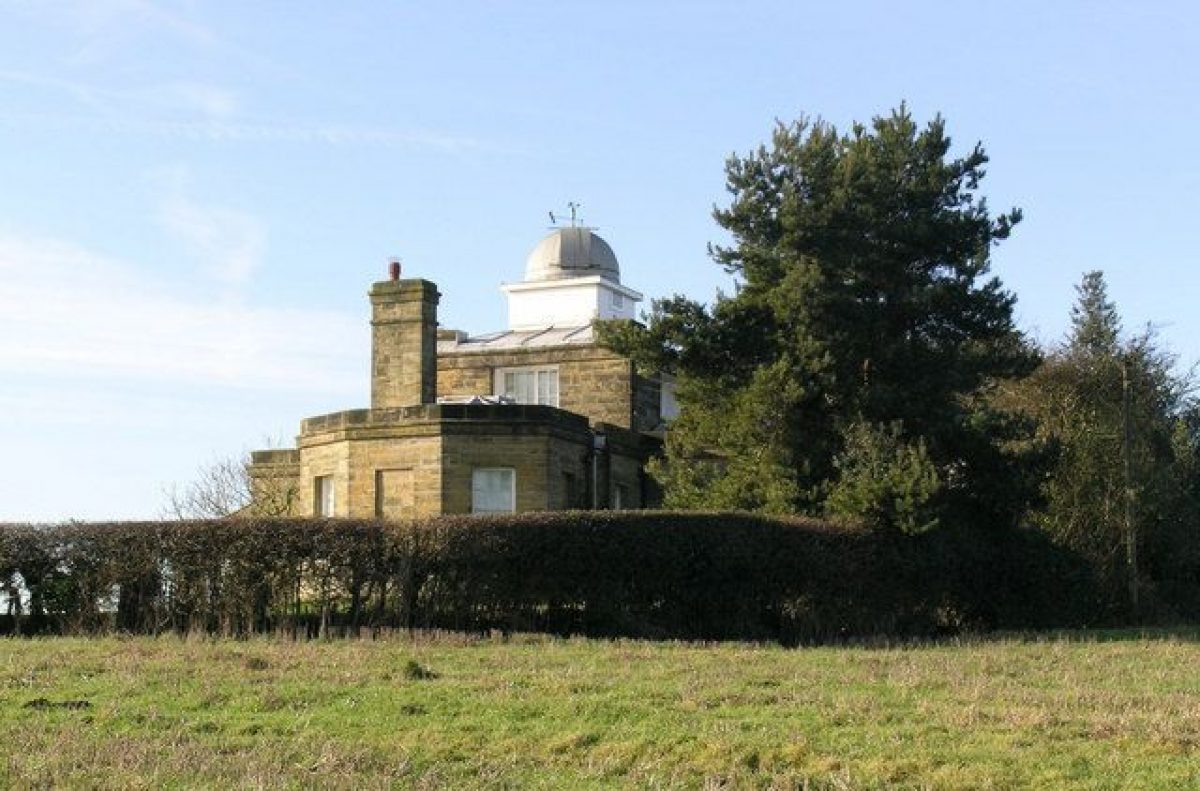
The park lies on the south-facing slope of a ridge that rises up to 195m at The Observatory. To the north the ridge falls away to the Duddon valley and further to the south the land falls down to the Darwell Stream before rising up to a sandstone ridge.www.historicengland.org.uk/listing/the-list
Landscape park originally laid out as a deer park in the 1740s, and considerably extended and enhanced in the early C19, with advice from Humphry Repton and a series of landscape follies designed by Sir Robert Smirke (1780-1867), situated within the park as well as outside as eyecatchers in prominent positions.
SITE DESCRIPTION
LOCATION, AREA, BOUNDARIES, LANDFORM, SETTING
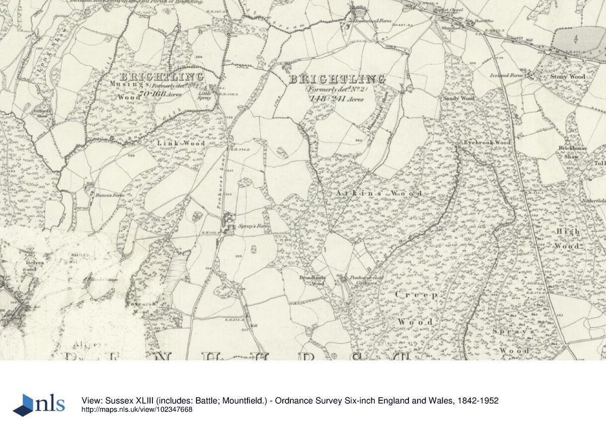
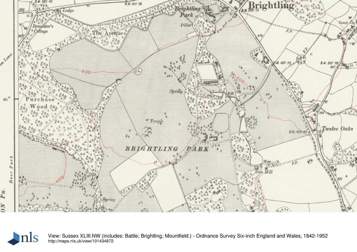
Brightling Park lies immediately to the south-west of the village of Brightling, 15km east of Heathfield and 10km to the north-west of Battle, and 3km west of the Darwell reservoir, in the High Weald Area of Outstanding Natural Beauty. The park lies on the south-facing slope of a ridge that rises up to 195m at The Observatory, where there are extensive views west, and south to the sea. To the north the ridge falls away to the Duddon valley and further to the south the land falls down to the Darwell Stream before rising up to the sandstone ridge that extends between Heathfield through Dallington to Battle and beyond. This landscape is typically Wealden, with wide views, enclosed valleys and a settlement pattern of scattered farms, hamlets and small villages.
The 212ha park, laid out initially in c1745-50 and thereafter progressively extended up to the early C19, is enclosed by a stone boundary wall built c 1825, except along its southern edge which is marked by a wide belt of woodland, Mansbrook Wood and Coblye Wood. Along the eastern boundary a tree belt lines the wall.
ENTRANCES AND APPROACHES
Brightling Park is situated in Brightling village, 150m south-west of the parish church, but the main approach to the house lies 1km west of Brightling village, where the entrance lies at Avenue Lodge situated at the north-west corner of the park. The mid-late C18 drive leads eastwards off the road (back in the direction of the village) and along the crest of the ridge, passing through a woodland called 'The Avenue', to reach the west front of the house. The Avenue is bounded on both sides by a stone ha-ha, its southern edge having been reworked to improve its ornamental effect following advice from Humphry Repton. The drive passes an alcove or summerhouse (designed by Smirke and listed grade II), with the makers mark 'Coade and Sealey' and dated 1803. It is positioned on the southern edge of the ha-ha and set so as to enjoy extensive views over parkland to the south. A secondary drive leads from a lodge (now demolished) in the south-west corner of the park, north-eastwards across the deer park, but is no longer in use.
PRINCIPAL BUILDING
Brightling Park house (listed grade II*), was built c 1700 and extended by the Fullers, principally in the 1720s, and then again in c 1745. The west and office wings, built by Smirke c 1810-2, were demolished in 1955, when the walled yard south of the house, with the laundry and game larder, was converted into an area of garden. The C18 stables and coach-house (listed grade II) stand to the south-east of the house and consist of one long building under a single roof span.
GARDENS AND PLEASURE GROUNDS
The pleasure ground circuit, divided from the park by a ditch, leads south from the house to, and around, the kitchen garden. This walk was laid out as recommended by Repton taking the form of two planting compartments- one surrounding the house, office court and pleasure ground and separated from the second sheltering the north and east side of the kitchen garden (Red Book, 1806). The walk linking these path circuits remained open to the parkland but was planted up to form one continuous plantation in the mid C19 (Sales Particulars, 1879).
The pillar surmounted by an anchor at the eastern end of the ha-ha was erected in the mid C20 by the Tew family.
PARK
The northernmost three ponds, in a chain of five, are set within and on the edge of the pleasure grounds, to the south of the kitchen garden. The ponds are divided by substantial dams, which run down the centre of the park, and were constructed in 1747 by John Fuller II and extended by Jack in the early C19. The outflow from the lowest of the ponds, a mid C19 addition, drove a sawmill. The present building (listed grade II, and now ruinous) dates from the late C19/early C20 but stands on the site of the earlier mill.
South of the pleasure grounds and west of the ponds is the village cricket pitch, dating from the mid to late C19, and a stone estate building.
Both Brightling Park and prominent points outside the park boundary are studded with follies- eyecatchers designed to highlight views from and to the park. The Temple, a rotunda (early C19, listed grade II* and designed by Smirke) is sited on the top of a knoll, 400m from the south-west corner of the kitchen garden and within the park. Repton recommended siting an eyecatcher in this position, although the area was already known as 'Temple Bank' prior to his visit (Russell & Gream, 1797). From the Temple there are views over to the Sugar Loaf, the Tower and the Observatory (see below). Purchase Wood, to the west of the knoll, was extended southwards c 1960, over a formerly open area. By the late C18 this was called The Paddock (Russell & Gream, 1797), thereafter the Deer Park (Attested Copy of Conveyance of Brightling Park Estate, 1879; OS 6" 1910). Much of the park is now divided into arable fields; few parkland trees remain.
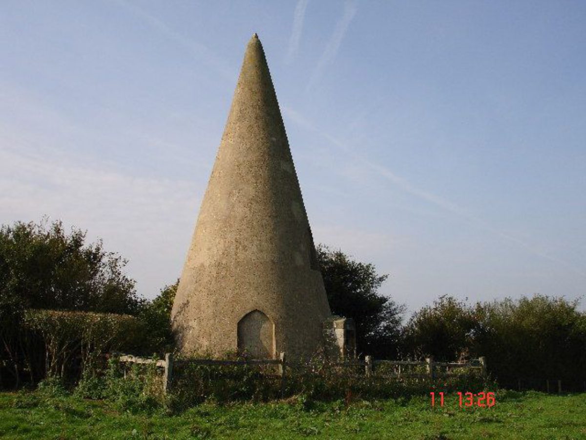
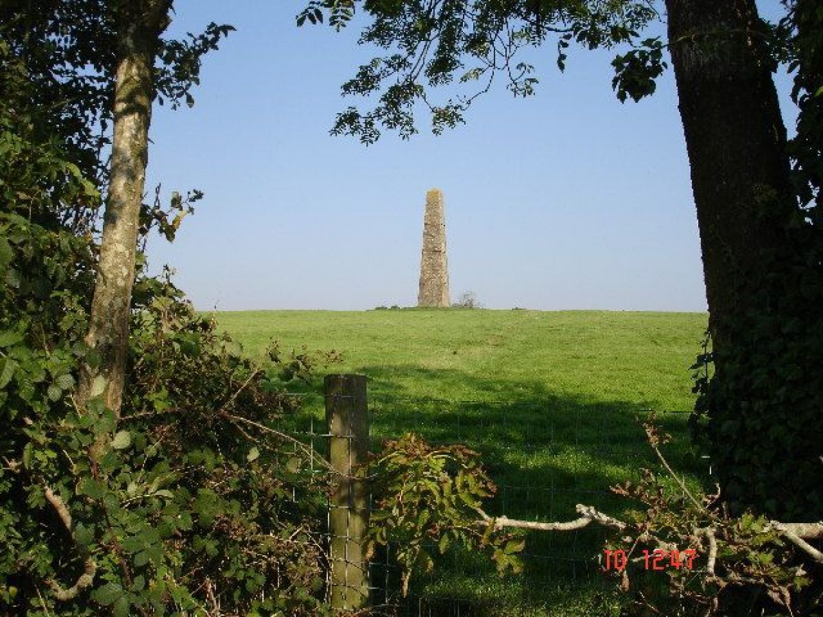
The follies without the landscape park occupy high points on the estate and all were built to Smirke's designs in the early C19. The Hermit's Tower (listed grade II) stands approx. 150m east of the park wall; the Observatory (listed grade II*) 150m to the west with Brightling Needle, sometimes called the Obelisk (listed grade II), 500m to its north; and the Pillar 125m to the south. The Sugar Loaf is sited 200m south of the south-western corner of the park. The last of Jack's follies was a mausoleum in the shape of a 25-foot high pyramid, built in 1810 in the churchyard just north of the house.
KITCHEN GARDEN
The mid C18 kitchen garden stands to the south of the house and is surrounded by a high brick wall with entrances in each face. It has a walled slip garden along the southern side.
REFERENCES:
Printed material
Rape of Hastings Architectural Survey, Brightling-Rosehill [P8/49], (1993)
E Shanes, Turner's England 1810-38 (1990)
S. Farrant, 'The Development of Landscape Parks and Gardens in Eastern Sussex c.1700 to 1820 - A Guide and Gazetteer' Garden History, Vol.17, no.2 (1989)
G Carter et al, Humphry Repton (1982), p 163
J Harris, The Artist and the Country House (1979), p 352
D Stroud, Capability Brown (1975), p 204
Sussex Archaeological Collections, 104, (1966), pp 61-88; 106, (1968), pp 73-88; 107, (1969), p 14-24
I Nairn and N Pevsner, Buildings of England: Sussex (1965), p 425
Anon, Historical Development of Brightling Park (East Sussex County Council Planning Department, undated).
Sussex County Magazine 29, (1955), pp 463-9
Maps
W Gardner and T Gream, A Survey of the Acual County of Sussex, 1" to 1 mile, 1795
Russell & Gream, A Survey & Plan of RoseHill Park the Seat of John Fuller Esq. Surveyed and drawn by Russell & Gream, 1797
OS Surveyor's Notebook Map 2" to 1 mile, 1807
OS Old Series, 1" to 1 mile, published 1813
Tithe Map for Brightling Parish, 1839 (East Sussex County Record Office)
Tithe Map for Dallington Parish, 1842 (East Sussex County Record Office)
Sales Particulars.
Map of 1879
OS 6" to 1 mile:
1st edition surveyed 1878
2nd edition surveyed 1910
2nd edition revised 1932
OS 25" to 1 mile:
2nd edition surveyed 1909
Illustrations
Drawing of Rosehill Park, 1784 (The Burrell Collection of Engravings, BL Add MSS 5670/65
Archival items
Rosehill in Sussex. A Seat of John Fuller Esq MP for that County by Humphry Repton 1806. (Bodleian Library, Oxford)
Fuller Papers in the care of Sussex Archaeological Trust 2/133 (East Sussex Record Office)
Attested Copy of Conveyance of Brightling Park Estate, 1879 (East Sussex Record Office, RAF/F2/17/1-2)
Description written : October 1992
Register Inspector : HJ
Revised KC, July 2000
Amended (owner comments): January 2001
- Visitor Access, Directions & Contacts
Telephone
01424 838241Website
https://www.brightlingpark.com/
- History
The following is from the Register of Parks and Gardens of Special Historic Interest. For the most up-to-date Register entry, please visit the The National Heritage List for England (NHLE):
www.historicengland.org.uk/listing/the-list
HISTORIC DEVELOPMENT
The first known mansion on the site was 'Sheperdes', built between 1540-61 by Michael Martin. In 1582 Thomas Martin sold it to Thomas Isted, and thereafter it passed to John Baker in 1608 and Edward English in 1652. English and his wife extended the estate and then sold it in 1684 to William Peake. His sister inherited it in 1685 and it was then sold in 1697, to Thomas Fuller (d.1720), a local industrialist, staying within the family until 1847.
The Fuller family's wealth was built on the Wealden iron industry. By 1703 their estates in Sussex generated £1,200 in rents and they had investments and iron furnaces at Collins Forge on the Burwash/Brightling border and Heathfield, the principal product being guns. Thomas Fuller extended the Brightling estate to 95ha and commenced a scheme of improvement, rebuilding the house c1699. In 1703 he gave the property to his nephew John Fuller (1680-1745) who that year married Elizabeth Rose, a Jamaican heiress who brought a considerable fortune to the family along with estates in the West Indies of over 1215ha. Fuller renamed the house Rosehill in her honour. At this stage the grounds were relatively compact despite Fuller's acquisition of an additional 59ha.
On John Fuller's death in 1745, the property was inherited by his son, John Fuller II (c 1705-55), who inheriting further estates from a cousin in 1752, spent a considerable fortune between 1745-55 on the Brightling estate. During this period he rebuilt the house, adding the west and the office wings. He extended his land ownership, purchasing 372ha until the estate reached 526ha, and laid out a deer park around the remodelled house, the park being bounded on its east, south and west sides by a tributary of the River Darwell. He diverted the public road leading directly past the north front of the house and acquired a long lease of land on Brightling Hill, as sheep grazing. He started planting up the park with clumps of trees and built a Chinese Temple and a keep in the grounds.
John Fuller II died without an heir in 1755 and the estate passed to his brother Rose Fuller (1708-77), who ran the family estates in Jamaica. By this time in addition to the overseas income, the rents from Sussex property came to £2,226 p.a. Rose Fuller did little to the estate before his death in 1777, the property then being inherited by his nephew known as 'Honest Jack', and more recently as 'Mad Jack'.
John Fuller III (1757-1833), was a friend and patron of JMW Turner and of the architect, Sir Robert Smirke (1780-1867) as well as other artists, architects and authors. Active as an MP and founder member of the Royal Institution, he inherited a considerable fortune, although the iron foundry industry had largely ceased, and set about developing the estate. In 1806 he commissioned Humphry Repton (1752-1818) to advise on the layout of the park. Repton presented his recommendations in the form of a Red Book in which he discusses a plan previously put forward by a 'Mr Brown' for improvements to the site. Lancelot Brown's son, also Lancelot, had married Frances Fuller, 'Mad Jack's aunt (sister of Rose Fuller), who he met in Lausanne in 1784, the year after his father's death, but there is no other evidence to confirm Lancelot Brown senior's involvement in the park.
Repton's main criticism of Rosehill was the siting of the house in such an exposed position, and he advised it be re-built in the Gothic style, elsewhere in the park or, failing this, that its surroundings be modified to provide a greater degree of shelter. Most of Repton's suggested improvements were not implemented, apart from some tree clumps on the southern boundary of the Avenue, between the house and kitchen garden and the erection of a temple to highlight the knoll (Tithe Map, 1838). Fuller continued his own scheme of improvements; commissioning Smirke to extend the main house c 1800 and to build a number of follies on the estate. An enclosing park wall was built at a cost of some £10,000. To celebrate his work, he commissioned Turner to do four watercolours of views in and around Rosehill. By the end of his life the estate had grown to 1530ha.
His cousin Augustus Fuller inherited the estate in 1834. During his tenure Augustus Fuller added a further 20ha to the estate. The name of the estate was changed to Brightling Park in 1879 when purchased from the Fuller family by Percy Tew. The estate remained in the Tew family until 1953, when it passed to Mr Tew's daughter-in-law, Rosemary Grissell. (Mr Tew's son had been killed in the war and his daughter-in-law married Michael Grissell). Death duties enforced the sale of part of the estate and partial demolition of the house in 1955. The parkland, extending to 482 acres (1992), remains in private ownership.
- Associated People
- Features & Designations
Designations
The National Heritage List for England: Register of Parks and Gardens
- Reference: GD2277
- Grade: II
Features
- Folly
- House (featured building)
- Earliest Date:
- Latest Date:
- Tree Clump
- Description: Most of Repton's suggested improvements were not implemented, apart from some tree clumps on the southern boundary of the Avenue.
- Earliest Date:
- Kitchen Garden
- Avenue
- Parkland
- Key Information
Type
Park
Purpose
Recreational/sport
Principal Building
Domestic / Residential
Survival
Extant
Hectares
212
Civil Parish
Brightling
- References
References
- {English Heritage Register of Parks and Gardens of Special Historic Interest} (Swindon: English Heritage 2008) [on CD-ROM] Historic England Register of Parks and Gardens of Special Historic Interest
- Stroud, D {Capability Brown} (1975) p 204 Capability Brown
- Carter, G et al {Humphry Repton} (1982) p 163 Humphry Repton
- Pevsner, N and Nairn, I {The Buildings of England: Sussex} (Harmondsworth: Penguin, 1965) p 425 The Buildings of England: Sussex