Introduction
Bilton Grange was originally a 13th-century monastic site. A Georgian house and park was altered and extended in the 1840s by Augustus Welby Pugin, and the grounds remodelled as gardens and pleasure grounds. The site is now a preparatory school, with sports facilities.
Terrain
The site occupies the level summit of a ridge of high ground which runs north-east from Dunchurch.www.historicengland.org.uk/listing/the-list
Mid-Victorian gardens and pleasure grounds set in a small park accompanying a country house designed by A W N Pugin, together with a walled garden to Pugin's design.
DESCRIPTION
LOCATION, AREA, BOUNDARIES, LANDFORM, SETTING
Bilton Grange stands mainly in the parish of Bilton, but the boundary with the parish of Dunchurch passes through the grounds to the south-west of the house. The site lies c 700m north-east of St Peter's church, Dunchurch, and some 2.5km to the south-west of Rugby. The 50ha site comprises c 11ha of gardens and pleasure grounds, and c 39ha of parkland, and occupies the level summit of a ridge of high ground which runs north-east from Dunchurch. The agricultural land beyond the park falls steeply away to the south-east, thus providing extensive views in this direction into Northamptonshire, the boundary with which county lies c 1.3km south-east of the house. The northern boundary is formed by public roads: the B4429 Ashlawn Road and, further to the west, the A426 Rugby Road. To the west the area is defined by a public footpath, fenced off from the park, with a scatter of private houses and their gardens occupying the ground between this and Rugby Road. To the south lie the grounds of Dunchurch Lodge (qv).
ENTRANCES AND APPROACHES
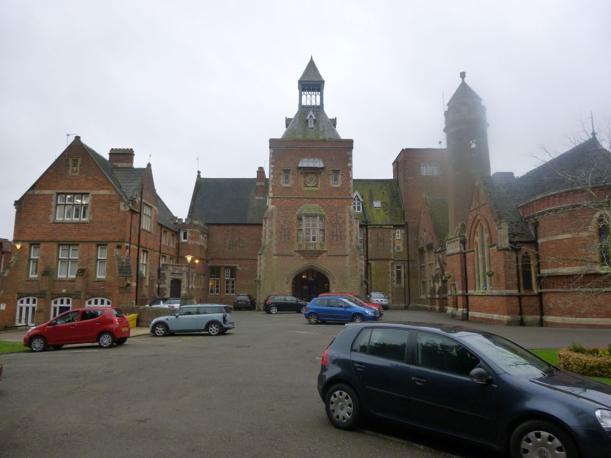
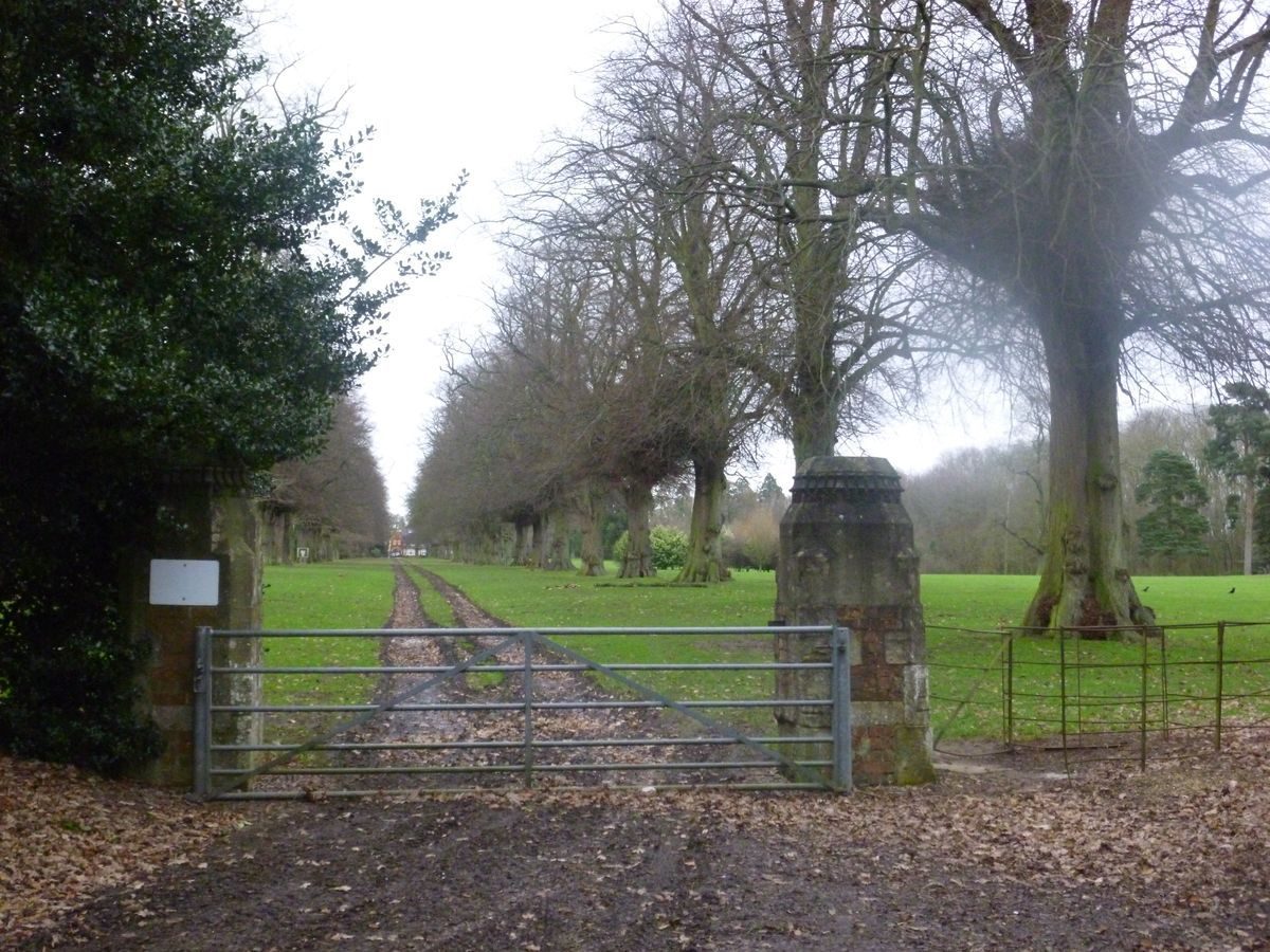
Today (1999) the site is approached from the A426 Rugby Road at its junction with Northampton Lane, c 400m north-west of the house. The entrance is flanked by low, late C20 reconstituted stone wing walls, and a two-storey lodge (listed grade II), dated 1883 and constructed in pale brick, stands within the site to the north of the drive. The mid C19 estate gas works which stood to the north-east of the lodge (sale particulars, 1861) do not survive. The tarmac drive passes south-east for c 130m through an avenue of limes, before reaching a small, late C19 red-brick inner lodge (not shown on the 1886 OS 6" map; listed grade II). The field to the south of the drive and outside the site here registered has (1999) permission for housing development. The inner lodge marks the boundary of the western park, and the point at which the drive is crossed by the public footpath which runs north from Dunchurch. The drive continues through an avenue of limes for c 160m to reach the mid C19 stable court and mid and late C20 school buildings and sports facilities which lie to the west of the house. The present drive was constructed in the late C19 by John Lancaster, and replaced an earlier approach from the north. This drive, which is shown on the OS 1" map (1834), left the A426 road at the south-west end of Cock Robin Plantation, c 400m north-west of the house, and swept east and south across the northern park. Some 260m north-east of the house the drive entered an avenue of limes which was planted prior to 1855 (plan annexed to indenture of that date). The lime avenue runs c 700m north-east across the park to North Lodge (listed grade II), a two-storey, brick, gabled structure which was built after 1861, possibly to designs by E W Pugin for John Lancaster, and which gives access to the site from the B4429 Ashlawn Road. The drive running through the avenue, today (1999) a grassy track, was created after 1861. Both the early C19 drive and the mid C19 drive turn south-west and pass through a pair of brick and stone gate piers (listed grade II) designed by A W N Pugin to enter the 'shrubbery avenue' (sale particulars, 1861), which today survives as evergreen shrubbery and mature trees. The shrubbery frames a vista of the tower, porte-cochère and front door, which are aligned on the axis of the avenue. The walled forecourt with entrance gates to the north shown in sale particulars of 1861 was replaced c 1890 when the school chapel was built to the west, and a classroom block to the east; the north side of the forecourt was left open. Today (1999) the forecourt is used for car parking and the semicircular lawn below the entrance tower shown in 1861 has been removed.
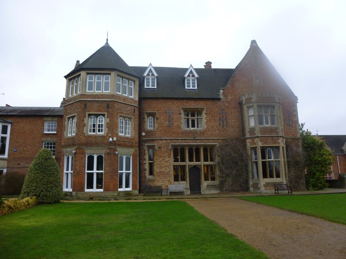
PRINCIPAL BUILDING
Bilton Grange (listed grade II*) stands to the south of the centre of the site. A W N Pugin was initially called in by Capt John Washington Hibbert in 1841 to design a modest extension to the existing C18 farmhouse (lithograph of elevation, V&A Museum); this plan remained unexecuted. Following his purchase of the estate in 1846, Hibbert recalled Pugin and commissioned a more ambitious scheme for a substantial two- and three-storey, red-brick country house. The C18 house was retained to the west of Pugin's building, adjacent to a new stable court, while a conservatory with a gothic timber roof was built against the south wall of the stables overlooking the gardens. Pugin's house is roughly L-shaped on plan and contains the principal reception rooms which overlook the gardens and park to the east and south. A gallery runs the full length of the building and connects with the older house to the south-west. Pugin and his builder, George Myers, found Hibbert a difficult patron, and it is possible that the general plan was due to their client (Illustrated London News 1855; Atterbury and Wainwright 1994). The chapel forming the west side of the forecourt was rebuilt in 1889 by Garlick and Sykes, and the east wing containing school rooms was built for the Rev Earle in 1891. To the west of the house stand several brick outbuildings converted to school use, and a variety of mid and late C20 school classrooms and sports facilities. Some 190m west of the house, Homefield, an early C20 house with late C20 additions, is now (1999) a nursery school.
GARDENS AND PLEASURE GROUNDS
Lying to the south and east of the house, the gardens comprise formal lawns, avenues and an area of informal walks adjacent to the southern boundary of the site. To the east of the house, below the windows of the former Library and Drawing Room, and reached by a door in the south facade leading from the Gallery, is a stone-flagged terrace enclosed by a 'noble open-work stone terrace wall, formed by a Register of the date of the House [1846], beautifully and quaintly cut in Old Letter' (sale particulars, 1861). The terrace overlooks a level lawn approached by stone steps at the south-east corner of the terrace, which is enclosed to the north by the late C19 east wing and a mid C20 school hall, while to the south a grass bank rises to the level of the formal gardens to the south of the house. In the C19 and early C20 this lawn was dominated by a mature tree, which an aerial photograph of c 1930 shows to have been removed and replaced by a simple formal garden.
A gravel walk extends below the south facade of the house, separating it from level lawns which are contained by raised walks along the west and south sides. The 1861 sale catalogue indicates that the lawns were then laid out with an arrangement of formal geometric beds. Parallel to, and c 10m from the south facade, is a cross walk aligned on a sunken circular pool at its eastern end, and widened as a circular feature at the midway point across the formal lawns. Some 60m south of the house a second cross walk, now (1999) partially levelled at its eastern end, divides the formal lawns from a bowling green, which is in turn enclosed to the south by a further raised cross walk c 100m from the house. This outline, with the two paths joining the west and east ends of the two surviving cross walks, is the earliest part of the Victorian layout, predating 1855 (indenture plan). The retaining walls, balustrades and urns shown in the 1861 sale catalogue do not survive, but C19 specimen conifers remain to the east of the lawns, with specimen Irish yews adjacent to the northern cross walk. A late C20 swimming pool has been constructed c 100m south of the house, in an area of informal lawns and shrubbery to the east of the formal garden.
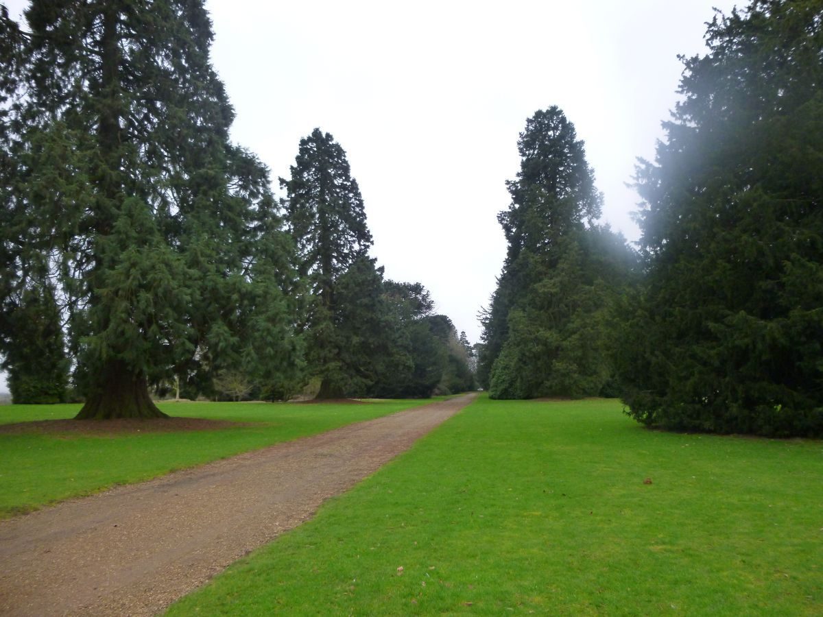
Aligned on the door on the south facade leading from the Gallery, and projecting the axis of that room into the gardens, a straight walk extends southwards for c 100m across the lawns, and continues for c 190m as the central path through an avenue of monkey puzzles, which are planted on raised earth mounds and alternate with specimen yews. At the southern end of the avenue, beyond a late C20 painted timber seat, stands a single central monkey puzzle flanked by a pair of western hemlocks. A row of yews, at some date headed at c 2m, line a subsidiary path which runs parallel to the avenue on its east side. To the west, a similar path is lined by mature copper beech and a variety of specimen trees underplanted with holly and specimen shrubs. Walks leading south-west and south-east from the monkey puzzle avenue enter an area of winding paths which weave through a complex of undulating banks, on which are planted a variety of C19 and C20 ornamental trees, underplanted with laurel and a range of hollies. Parallel, and to the west of the beech walk and monkey puzzle avenue, forming the western boundary of the pleasure grounds, is a second north/south axial walk which is marked by an avenue of Deodar cedars. This walk is aligned to the north on the mid C19 conservatory to the west of the house. The line of the walk, but not the avenue trees, is shown on the 1861 sale plan, at which date the western boundary still had to assume its present straight line; both the boundary realignment and planting were completed by 1886 (OS). The southern extension of the pleasure grounds, including the avenues, post-dates 1855 (indenture plan) but was laid out within a framework of boundaries which had been established by that date, and which included a narrow plantation of oak along the southern boundary.
PARK
The main area of parkland lies to the north of the house, and is bisected unequally by the lime avenue leading from the house to North Lodge. The park is screened from the public road to the north and north-west by Cock Robin Plantation, which incorporates a closely planted screen of Wellingtonia. Within the Plantation, well screened from the park by a dense under-planting of evergreen shrubs, stand Cock Robin Buildings (listed grade II), formerly an inn but today (1999) private residences. The Buildings and their associated gardens are not included in the area here registered. The Plantation post-dates 1855 (indenture plan), prior to which the park boundary ran parallel to, but c 150m south-east of the public road, but predates 1861 (sale particulars). The western or larger section of the north park is laid out with sports pitches among a light distribution of specimen trees, several of which are boundary oaks retained from the earlier field system. Two sports pavilions accompany the pitches, while a miniature golf course has been constructed parallel to the western boundary of the park (1998).
East of the lime avenue the park remains mown grass with scattered specimen trees, and is divided from fields which fall away to the east by fencing which joins three small areas of woodland. At the southern end of Fox Covert, also known as Bath Wood, c 270m north-east of the house, is an early C20 open-air swimming pool and associated timber changing rooms (disused 1999), formed from an earlier pool.
The parkland on the east-facing slope below the house is today (1999) in arable cultivation, but retains scattered groups of Wellingtonia, together with oaks from hedgerows which were removed in the course of mid C19 improvements. Some 350m south-east of the house, and immediately outside the area here registered, are the buildings of Dunchurch Lodge Farm, which until 1887 formed part of the Bilton Grange estate.
KITCHEN GARDEN
Lying some 200m south-west of the house, the brick-walled kitchen garden (listed grade II) occupies the south-west corner of the site, to the west and parallel to the southern end of the Deodar cedar avenue. The kitchen garden has four entrances, one in the centre of each wall, those to the north, east and west being closed by an oak double door set in a stone gothic arch, with a small, fish-scale-tiled porch roof above on the inner face of the wall. The entrance in the south wall has been removed; when in existence it led to glasshouses constructed against the outer face of this wall (no longer surviving, 1999), a slip garden, and a path leading to the informal walks to the south of the cedar and monkey puzzle avenues. The garden is today laid to grass, with late C20 ornamental planting against the inner face of the north and west walls. A central, sunken, octagonal dipping pool surrounded by stone kerbs and a paved walk was originally approached by four flights of stone steps, only two of which survive today. These were aligned on the four doors set in the garden walls. Walks dividing the garden into quarters do not survive. The internal arrangement of the kitchen garden is shown on an aerial photograph of 1947, at which date it remained in full cultivation.
A 20m deep slip garden which runs parallel to the eastern wall is divided from the pleasure grounds by a hedge of Portugese laurel. Adjoining the outer north-west corner, and at the end of a holly-hedged slip garden beyond the north wall which remains (1999) in cultivation as a vegetable and flower garden, stands a mid C19 two-storey brick gardener's house (listed grade II). A ground-floor window in the south facade allows oversight of the walled garden.
The walled garden and the gardener's house formed part of A W N Pugin's mid C19 scheme for Capt Hibbert (indenture plan, 1855; sale particulars, 1861).
REFERENCES Used by English Heritage
F Smith, Warwickshire Delineated (1819), p 107
J C Loudon, Encyclopaedia of Gardening (1822), p 84
J Burke, A Visitation of the Seats ... i, (2), (1852), p 157
Illustrated London News, 27 January 1855, p 93 [engraving]
M H Bloxam, Bilton Grange (1887)
W O Waite, Rugby Past and Present (1893), p 279
Victoria History of the County of Warwick VI, (1951), pp 31-2
N Pevsner and A Wedgewood, The Buildings of England: Warwickshire (1966), pp 94-5
P Stanton, Pugin (1971), pp 176-7, 200
A Wedgewood, A W N Pugin and the Pugin Family (1985)
G Tyack, The Country Houses of Warwickshire 1800-1939 (1989), pp 31-7
P Atterbury and C Wainwright, Pugin A Gothic Passion (1994), pp 53-4, 119, 122, 137, 149, 178-9, 204-5, 295
G Tyack, Warwickshire Country Houses (1994), pp 35-7
M Edwards, The History of Bilton Grange before 1887 (1996)
Bilton Grange, Register Review Report, (Hazel Fryer Associates 1996)
Bilton Grange near Rugby, A Brief History, (Warwickshire Gardens Trust 1997)
Maps [all held at Warwickshire County Record Office]
W Yates and Sons, Map of Warwickshire, surveyed 1787-9, published 1793
C Oakley, Tithe map for Bilton parish, 1840 (CR569/34)
Tithe map for Dunchurch parish, no date (around 1842) (CR569/92)
Plan annexed to indenture dated 3 April 1855 (CR1091/151)
Plan of house, offices and conservatory, Sale particulars, 1861 (EAC 411/4)
OS Maps
OS Old Series 1" to 1 mile, 1834
OS 6" to 1 mile: 1st edition published 1886; 2nd edition published 1900; 3rd edition published 1926; 1938 edition
OS 25" to 1 mile: 1st edition published 1886; 2nd edition published 1905; 3rd edition published 1925
Illustrations
A W N Pugin, Perspective view of proposed addition to Bilton Grange, 1844 (Victoria and Albert Museum, London)
Augustus Butler, Bilton Grange, Co Warwick The Seat of Captain Washington Hibbert, 1852 (Warwickshire County Record Office)
Thomas Way, Bilton Grange, no date (around 1855), (Warwickshire County Record Office)
Engraving, Bilton Grange - General View, from Sale particulars, 1861 (EAC 411/1), (Warwickshire County Record Office)
Photograph, Bilton Grange from the south-east, around 1880 (Rugby Library collection)
Pan-Aero pictures, aerial photograph postcard view, around 1930 (private collection)
Aerial photograph, 1947 (Warwickshire SMR)
Archival items
Deeds and leases for Bilton Grange estate, 1703-1871 (1091/75-155), (Warwickshire County Record Office)
J G Crace papers, including material relating to construction and decoration of Bilton Grange, mid-19th century (Crace MSS/PUG 3), (RIBA)
Sale particulars, 1861 (EAC 411/1), (Warwickshire County Record Office)
Sale particulars, around 1887 (Rugby Library Collection)
Description written: December 1999
Amended: May 2000
Edited: December 2000
- Visitor Access, Directions & Contacts
Directions
South of Rugby on the A426
Owners
Bilton Grange School
- History
The following is from the Register of Parks and Gardens of Special Historic Interest. For the most up-to-date Register entry, please visit the The National Heritage List for England (NHLE):
www.historicengland.org.uk/listing/the-list
HISTORIC DEVELOPMENT
In the mid-12th century Pipewell Abbey, Northamptonshire, acquired a grange in the parish of Bilton. At the Dissolution in 1539, the grange was bought by its tenant, Edward Boughton, in whose family it remained until 1768, when it formed part of the marriage settlement of Anna Boughton and Alexander Hume. By 1780 a farmhouse accompanied by gardens, outbuildings and orchards stood on the site of the present mansion. Abraham Hume inherited Bilton Grange from his father in 1794, and in 1819 Francis Smith referred to it as a 'handsome house'. Hume was, however, forced to take a series of mortgages on the estate in the early 19th century, and in 1839 it was let to Captain John Washington Hibbert, his widowed mother, and his elder brother Thomas, described as 'lunatic' (Edwards 1996). Hibbert (1805-75) was the son of a Jamaican plantation owner, and cousin of George Hibbert, MP (1757-1837), described by J C Loudon as an encourager 'of exotic botany' (Loudon 1822). Hibbert married in 1839 Julia Talbot (nee Titchbourne), widow of Lt Col Charles Talbot, brother of the fifteenth Earl of Shrewsbury whose son by this marriage, Bertram (born 1832), in 1852 succeeded as seventeenth Earl. In 1841 Hibbert commissioned plans for a modest extension to Bilton Grange from Augustus Welby Northmore Pugin (1812-52). Following the death of his brother Thomas in 1845, Hibbert purchased the estate from Abraham Hume in April 1846, and the same year commissioned fresh plans from Pugin. The choice by Hibbert of Pugin may have resulted from the architect's connections with the sixteenth Earl of Shrewsbury, for whom he built Alton Towers, Staffordshire (see description of this site elsewhere in the Register) at a similar date, there working alongside W A Nesfield (1793-1881). In 1861, five years after the seventeenth Earl's death at the age of twenty-four, Bilton Grange was offered for sale, and was purchased by John Lancaster (died 1884), an iron and coal magnate and MP for Wigan. Lancaster's heirs sold Bilton Grange in 1887 to the Rev Walter Earle, but retained neighbouring Dunchurch Lodge (see description of this site elsewhere in the Register). The Rev Earle opened the house as a preparatory school, in which use it continues (1999).
- Associated People
- Features & Designations
Designations
The National Heritage List for England: Register of Parks and Gardens
- Reference: GD4036
- Grade: II
Features
- Lawn
- Topiary
- Terrace
- Mixed Border
- Key Information
Type
Park
Purpose
Ornamental
Principal Building
Education
Survival
Part: ground/below ground level remains
Hectares
64
Open to the public
Yes
Civil Parish
Dunchurch
- References
References
- {English Heritage Register of Parks and Gardens of Special Historic Interest}, (Swindon: English Heritage, 2008) [on CD-ROM] Historic England Register of Parks and Gardens of Special Historic Interest
- {Victoria History of the County of Warwickshire Volume 6} ([n.p.]: [n.pub], 1951), pp. 31-2 Victoria County History: Warwick, Volume 1
- Pevsner, N. and A. Wedgwood, {The Buildings of England: Warwickshire} (Harmondsworth: Penguin Books, 1966), pp. 94-5 The Buildings of England: Warwickshire
- Tyack, G., {Warwickshire Country Houses} (Chichester: Phillimore, 1994), pp. 35-7 Warwickshire Country Houses