Introduction
Newnham Paddox has a mid-18th-century landscape park occupying about 115 hectares, with 19th-century formal gardens of some 20 hectares which are now (late-20th century) largely abandoned. The park was landscaped by Lancelot Brown between 1745 and 1753. A 12 hectare sculpture park was laid out in the early-21st century.
Terrain
The site is generally quite level, with a gentle slope rising to the north.www.historicengland.org.uk/listing/the-list
A mid C18 landscape laid out by Lancelot Brown from 1746, with early C19 alterations by John Webb and late C19 gardens by John Fleming.
DESCRIPTION
LOCATION, AREA, BOUNDARIES, LANDFORM, SETTING
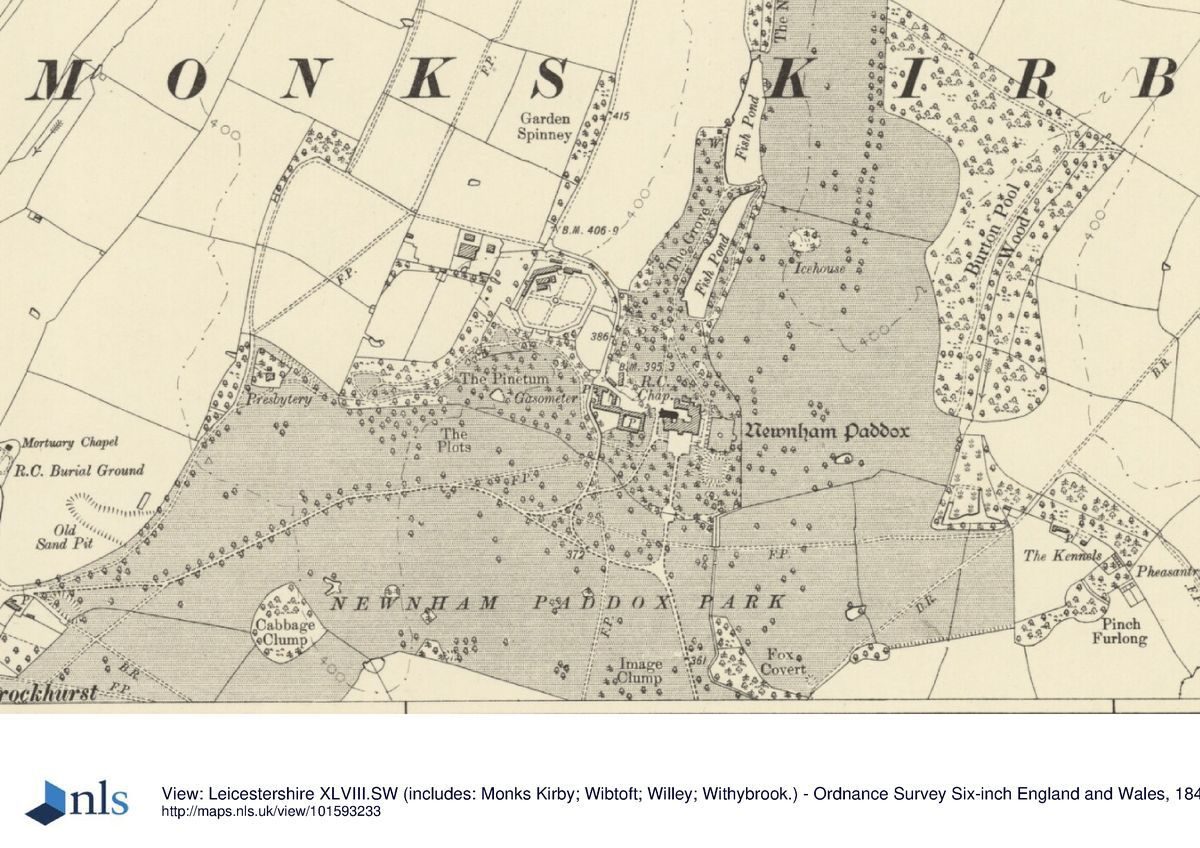
Newnham Paddox is situated c 0.75km east of the village of Monks Kirby and c 1.75km north-east of the village of Pailton, some 1.25km south-west of the A5 Watling Street, which here forms the boundary between Warwickshire and Leicestershire. The c 135ha site comprises some 20ha of gardens, pleasure grounds and ponds, and c 115ha of park and woodland. To the south-east the site is bounded by A427 Lutterworth Road, while to the west the site adjoins domestic premises in Brockhurst, a hamlet immediately to the east of Monks Kirby. To the north, east and south the site adjoins agricultural land, and is enclosed by hedges and fences. The site is generally quite level, with a gentle slope rising to the north. A ridge of slightly higher ground extends south into the park to the west of the site of the house, while to the east a small stream flows south through a shallow valley. A further stream, the Smite Brook, crosses the south park from east to west in a shallow valley c 700m south-east of the house site. Some 1km north of the house site a shallow plantation, Long Spinney, extends c 5km from north-west to south-east along Coal Pit Lane and closes views to the north. Long Spinney was enclosed in 1743 and planted with elm and ash in 1745 (Building Book). Further areas of woodland, including Garden Spinney, are significant in views to the north-west.
ENTRANCES AND APPROACHES
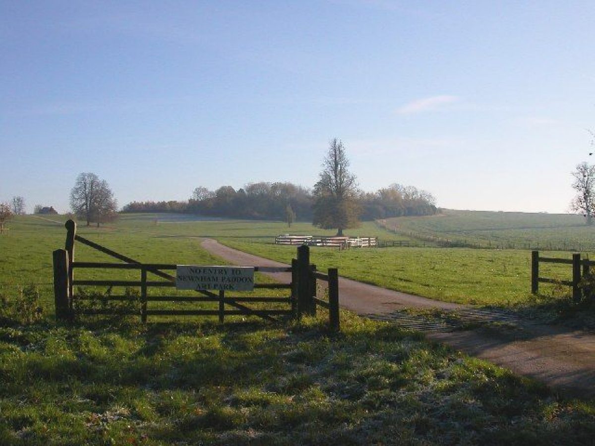
Newnham Paddox is approached from Monks Kirby to the west. Some 700m north-east of the parish church a simple gate leads east from Brockhurst Lane. The tarmac drive leads c 240m east through the park, before sweeping north-east for c 300m and ascending a slight ridge which extends south into the park. A C20 drive leads north to Park House, a late C19 brick house constructed for the eighth Earl in the shelter belt north of the park as a presbytery for the Roman Catholic church in Brockhurst. Descending, the principal drive continues east-north-east for c 270m before turning south-east for c 100m and joining the south drive. A triangular area of grass planted with specimen trees is enclosed by drives, one of which leads c 160m north to reach the west side of the C18 stable court. A service drive leads north from the stables to the kitchen garden and park.
The south drive leads north-west from the A427 Lutterworth Road, passing for c 800m through a late C19 avenue of limes (VCH) which descends into a shallow valley. A lodge shown to the west of the entrance on the late C19 OS map does not survive. Crossing the Smite Brook on Folly Bridge, the drive climbs gently north-west and north-north-west for c 550m through the south park to join the west drive to approach the stables. Folly Bridge may be the bridge to which Walpole referred in 1755 (Toynbee 1927-8). Today (2000) the south drive survives as a track. It was altered to its present form as part of the improvements undertaken by John Webb for the seventh Earl of Denbigh in 1818-21 (Clwyd RO). Webb appears to have developed an existing drive, and a formal avenue and approach from the south is shown in Kip's view of Newnham published in 1707.
The C18 and C19 course of the drive continues for c 100m through a late C19 avenue, and thence c 80m north to enter a forecourt south of the site of the house through monumental early or mid C18 wrought- and cast-iron gates (all listed grade I). The central pair of gates is surmounted by an elaborate overthrow and flanked by a pair of screens incorporating a decorative circular motif. The side screens are flanked by a pair of lower, arch-topped gates which are supported to east and west by a pair of late C19 brick and stone piers. The central gates and screens are supported on C18 open-work, square-section, cast-iron piers surmounted by vase finials ornamented with flowers and foliage. The gates and screens were brought to Newnham Paddox c 1870 by the eighth Earl of Denbigh from Berwick House, Shropshire, an estate which he had inherited from an uncle and which he sold to redeem mortgages on the Newnham estate. The gates were made by the Davies brothers in the 1720s (Stamper 1996). The C19 forecourt was enclosed to east and west by low stone balustrades, with ornamental trees and shrubs planted on banks beyond the drive and on lawns to the west of the house. Today the outline of the forecourt is indicated by surviving C19 planting and the outer grass banks, and yew hedges to the south. Kip's early C18 view indicates walled gardens to the south of the house entered through gates aligned with the south avenue and the principal door of the house. A pair of pavilions flanked a gate leading from the outer court to a middle court laid out with four lawns divided by cruciform walks, while further gates set in a pale fence led to an inner court enclosed on three sides by the C17 house (Kip, 1707).
PRINCIPAL BUILDING
Newnham Paddox was demolished in 1952, and today (2000) the principal building to which the site relates is the C18 stable court which was converted to domestic use in the mid C20. The stables lie c 50m west of the site of the mansion, while a late C20, two-storey, square-plan house of timber construction has been built on the site of the forecourt.
The mansion demolished in 1952 incorporated the house constructed by Lancelot Brown for the fifth and sixth Earls in 1754-68; this house was in turn on the site of that built in the early C17, and may have incorporated some of its fabric (Tyack 1994). Brown's new, Palladian-inspired south facade comprised two storeys under a pitched roof, with a projecting central pediment and a pair of low, pyramid-roofed towers to east and west. The principal rooms were arranged on the first floor. Wings extended north behind the east and west towers, with a chapel in the west wing, echoing the 'H' plan of the C17 house. A further wing to the north occupied the site of the principal wing of the C17 house. The mid C18 house was constructed in brick with stone dressings, and is shown in a watercolour view of c 1800 in the Aylesford Collection. In the early C19 the seventh Earl added a third storey to Brown's house, and covered the exterior with stucco (ibid). By the late C19 the house required extensive repairs, and the eighth Earl commissioned T H Wyatt to remodel it in a French Renaissance style with pavilion roofs over the mid C18 corner towers and new towers at the north ends of the wings. Mansard roofs, a projecting porch and exposed brickwork with stone ornaments were also added to the house. The chapel was rebuilt in Gothic style in 1888 for the eighth Earl who was a convert to Roman Catholicism.
GARDENS AND PLEASURE GROUNDS
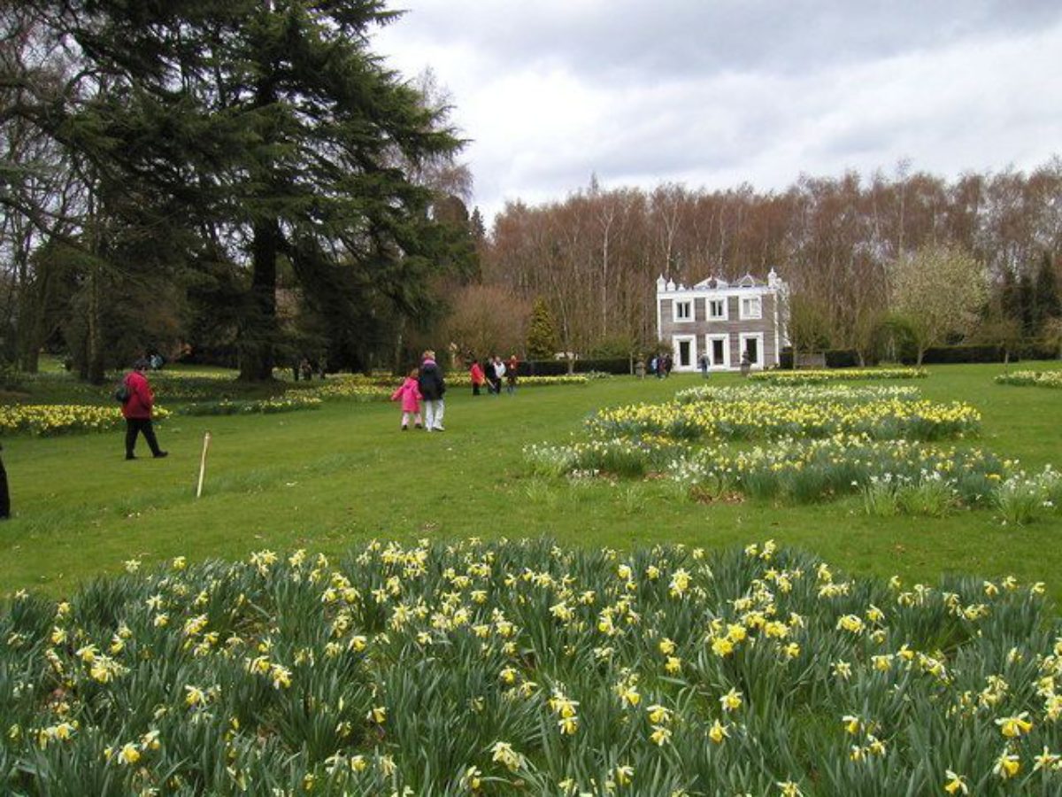
Formal terraced gardens lie to the east of the site of the mansion, with areas of informal pleasure grounds to the north and west.
A shallow flight of stone steps descends from the site of the forecourt to a wide grass terrace which extends c 60m south to an area of lawns and specimen trees, and c 60m north to a flight of stone steps which descends to the pleasure grounds. To the south-east an east-facing grass slope descends to a sunken rectangular lawn. Today this lawn is enclosed to the east and south by evergreen shrubbery. Early C20 photographs show the lawn planted with specimen conifers and topiary yews (Rugby Library Collection). To the north of the sunken lawn and below the site of the east facade of the house, a further sunken lawn is approached from the upper terrace by a flight of stone steps. This area is now enclosed by mature conifers to the north and east and is entirely laid to grass, with a central, circular, stone-kerbed fountain basin (dry, 2000). This northern sunken lawn was a late C19 formal flower garden with perimeter walks enclosing lawns and geometric flower beds; semicircular bastions projected from the centre of the north, south and east sides of the garden, which appears to have been enclosed by hedges (OS 1886; photograph, Rugby Library). The formal gardens to the east of the house were laid out c 1870, and are attributed to John Fleming, gardener at Cliveden, Buckinghamshire (qv) (DNB 1993); they replaced the southern end of Lancelot Brown's serpentine artificial river which had itself been formed from the late C17 or early C18 formal Great Canal in 1746 (Building Book). The serpentine river was partially drained c 1870 when it was found that the foundations of the east wing required extensive repair (Tyack 1994). The formal gardens and the pleasure grounds to the north are separated from the park to the east by a brick channel through which runs the stream which formerly fed the serpentine water.
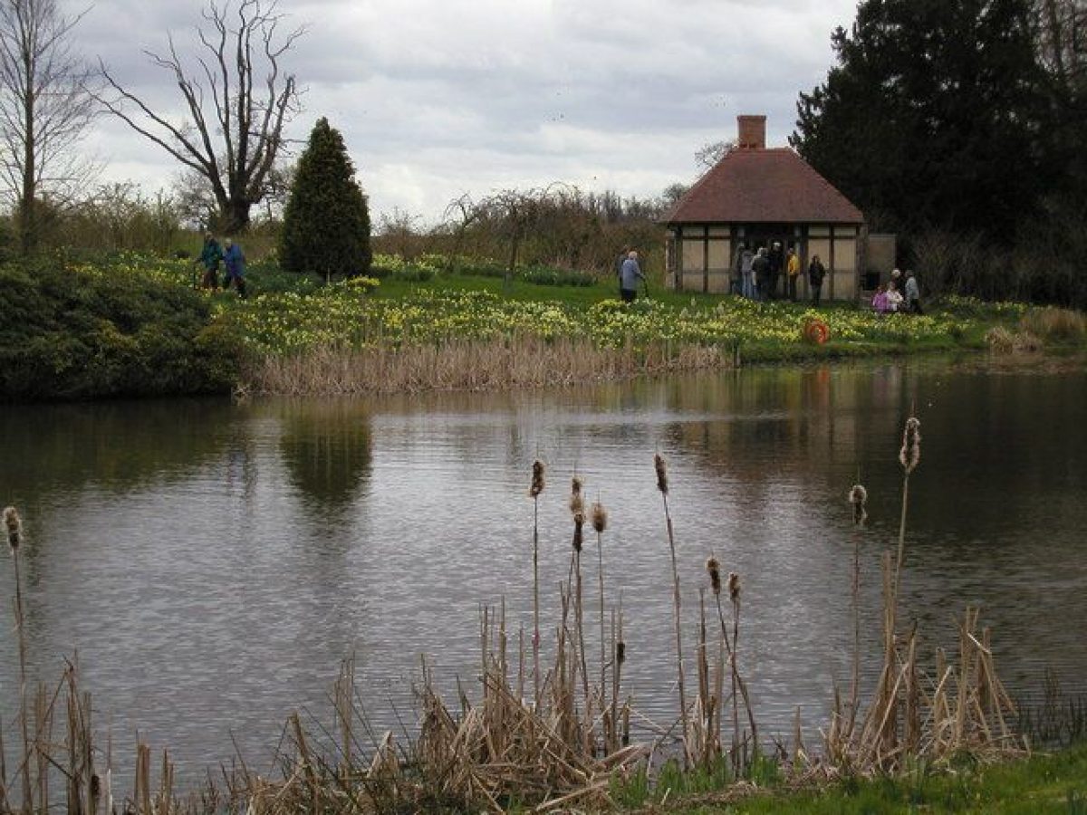
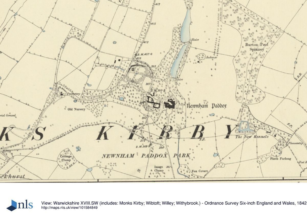
A walk leads north-west from the steps at the north end of the east terrace. To the north-east a gently sloping lawn on the site of the upper section of the mid C18 serpentine water is planted with specimen trees and groups of ornamental shrubs. Some 140m north-west of the terrace, the walk joins a formal walk which led north from the west side of the house. There is a further area of lawns, specimen trees and shrubs to the west of the formal walk. To the north of the junction the walk continues as an informal path, passing for c 250m through an ornamental plantation, The Grove, to the west of an informal lake. The Grove, today characterised by C19 ornamental planting, was planted with home-grown ash and elm from Lutterworth in 1743 (Building Book). The lake originated as a rectangular pond in the park which is shown in Kip's early C18 engraving. Modified by Brown in the mid C18 and planted with 'hanging slopes' in 1748 (ibid), in 1770 the 'Middle Pond' was incorporated into the serpentine water (WCRO). This arrangement is reflected on the 1842 Tithe map.
An informal walk leads north-east along a dam which retains a further informal lake, the Middle Pond, which extends north into the park; this lake is also shown as a rectangular pool in Kip's engraving (1707). The walk continues along the east bank of the Middle Pond which is planted with specimen trees and ornamental shrubs. At the south-east corner of the Middle Pond a mid C20 summerhouse is constructed on the site of a C19 structure (OS 1886). The walk returns west across the dam which retains the Middle Pond, to rejoin the principal walk through The Grove.
A walk extending west across an area of informal lawns south of the stables which replace the formal parterres shown by Kip (1707) leads to the western pleasure grounds. Here a wide, mown grass walk extends west-north-west parallel to the boundary between the pleasure grounds and the park to the south, which is here formed by metal estate fencing. This walk is partly lined by mature trees which survive from a more regular avenue shown on the late C19 OS map. To the north of this walk a south-facing sloping area of grass planted with C19 specimen conifers was laid out c 1870 as a pinetum. A curvilinear walk sweeps north-west and west around the Pinetum, leading through dense evergreen shrubberies to the remains of a small conservatory constructed against the outer face of the south wall of the kitchen garden, c 260m north-west of the site of the house. Low brick walls survive from this structure, together with scoriae attached to the rear wall. In the vicinity of the conservatory are the remains of a C19 or early C20 wrought-iron pergola or arched supports for climbing plants. The perimeter walk continues south-west from the conservatory, passing through further areas of evergreen shrubbery. Some 60m south-west of the site of the conservatory are the remains of a mid or late C19 Jacobean-style sundial base. The walk continues c 80m south-west to reach the western end of the south perimeter walk. To the west a further area of pleasure ground is today densely planted with evergreen shrubbery and C19 specimen trees; the C19 circuit of curvilinear walks in this area is largely lost. The western pleasure grounds were developed in the late 1860s and early 1870s, possibly with the advice of John Fleming. Accounts record payments to Messrs Veitch and Sons and to Batley of Rugby for plants in 1869(70 (WCRO). An account of 1864(5 for the reconstruction of the conservatory (WCRO) suggests that the existing building replaced an earlier structure; however the 1842 Tithe map does not indicate the Pinetum as an area of garden.
PARK
The park lies to the north, east, south and south-west of the site of the house. The northern and eastern areas of park remain (2000) as pasture with scattered deciduous trees on ground which slopes up to the north and north-east. In the late C19 the park was noted for its mature elms, some of which survived from the late C17 or early C18 formal avenues illustrated by Kip (1707), but many have succumbed to disease in the mid and late C20 (VCH). To the north-east the park is bounded by Burton Pool Wood, to the south of which a marshy area is the remains of a triangular-shaped pond which is shown on the Tithe map (1842). Some 300m north-east of the site of the house, a late C18 or early C19 icehouse (listed grade II) of domed, brick construction is covered by a mound. The mid C19 Tithe map indicates that the northern park formerly extended up to Long Spinney, which formed a boundary plantation screening Coal Pit Lane. This land had been disparked by 1906 (OS), and is now in arable cultivation. The late C19 OS map (1886) shows remnants of an avenue extending north-north-east across the park to join Coal Pit Lane c 1.2km north-east of the house. A ride, possibly that cut in the 'New Plantation' in 1781, extends the length of Long Spinney; a further ride passes through Burton Pool Wood to join the remnant avenue c 670m north-east of the house site.
The southern area of park is largely in arable cultivation, but boundary plantations survive on the A427 Lutterworth Road. Mid and late C20 commercial plantations have been made to the south of the site of the house. The south-west park remains pasture with scattered mature trees to the north and south of the west drive. A further area of plantation, Cabbage Clump, is planted on a west-facing slope c 670m south-west of the site of the house.
KITCHEN GARDEN
The kitchen garden lies c 130m north-west of the stables and c 200m north-west of the site of the house, immediately to the west of the northern pleasure grounds. Octagonal on plan, the garden is enclosed by brick walls c 3m high with entrances set at the centre of the east, north and west walls. The garden, which is no longer in cultivation, was constructed in 1770-2, possibly to the design of Brown (Building Book). The late C19 OS map shows extensive ranges of glass built against the inner face of the north-west and north walls; these do not survive. A valuation of 1871 refers to a peach house, vineries, fig house, melon pits and a mushroom house in the garden (WCRO); the construction of a melon pit in 1782 is recorded in the Building Book. The slip gardens shown on the 1886 OS map to the north, east and south-east of the garden are no longer in cultivation.
REFERENCES
J Beeverell, Les delices de la Grande Britagne V, (1707), p 872
L Knyff and J Kip, Britannia Illustrata I, (1707)
W Dugdale, The Antiquities of Warwickshire (2nd edn 1730), pp 85-9
Gardeners' Chronicle, ii (1884), p 491
J Horticulture and Cottage Gardener 27, (1893), p 268; 43, (1901), pp 154-5
P Toynbee (ed), Horace Walpole's Journals of Visits to Country Seats 1751-84, Walpole Society VII, (1927-8), p 63
Victoria History of the County of Warwickshire VI, (1951), pp 173-5
N Pevsner and A Wedgewood, The Buildings of England: Warwickshire (1966), p 357
Warwickshire History, I (1969), pp 3-17
G Tyack, Warwickshire Country Houses (1994), pp 148-51
P Stamper, Historic Parks and Gardens of Shropshire (1996), pp 28-9
Maps
H Beighton, A Mapp of Warwickshire, 1" to 1 mile, surveyed 1722-5, published 1729
H Beighton, A Map of Knightlow Hundred, surveyed 1725, published 1730
W Yates and Sons, Map of Warwickshire, surveyed 1787-9, published 1793
Tithe map for Monks Kirby parish, 1842 (CR2026/76), (Warwickshire County Record Office)
OS Old Series 1" to 1 mile, published 1835
OS 6" to 1 mile:
1st edition published 1886
2nd edition published 1905
OS 25" to 1 mile:
1st edition published 1886
2nd edition published 1904
Illustrations
J Kip, Newnham Padox in Warwickshire, 1707
Watercolour, Newnham Paddox from the south-east, c 1800, (Aylesford Collection, Birmingham Reference Library Archive)
Engraving, Reception of the Hon Major Feilding, at Newnham Hall, on his return from the Crimea (Illustrated London News) [coy at NMR: BB76/7762]
Photographs, mid C19 (Z372/1(2), (Warwickshire County Record Office)
Photographs, late C19 and early C20, (Rugby Library photographic collection)
Archival items [all held at Warwickshire County Record Office unless indicated otherwise]
Feilding family collection, including accounts, estate papers and surveys (CR2017)
James Fish, A Survey Book containing the Survey of the Manours and Lordships of Newnham Paddox ... in the County of Warwick (no plan), 1724 (CR2017/E46)
An Account of Fish put in the Waters At and About Newnham, 1747-c 1777 (CR2017/E106/1)
Newnham Paddox Building Book, 1743-1830 (MI416)
W Hitchcock, Particular of the Estate of the Right Hon William Bazil Percy, Earl of Denbigh and Desmond, in the Parishes of Monks Kirby and Willey ... (no plan), 1805 (CR2017/E47)
Accounts, including garden accounts, C18 and C19 (CR2017/A232)
Correspondence between Thomas Lloyd, agent to the Earl of Denbigh, and John Webb, 1818-21 (D/BC382), (Clwyd County Record Office)
Description written: April 2000 Amended: May 2000, September 2000
Register Inspector: JML
Edited: January 2001
- Visitor Access, Directions & Contacts
Directions
North of the B4027, west of the A5 at Lutterworth.
- History
The following is from the Register of Parks and Gardens of Special Historic Interest. For the most up-to-date Register entry, please visit the The National Heritage List for England (NHLE):
www.historicengland.org.uk/listing/the-list
HISTORIC DEVELOPMENT
Newnham Paddox was acquired by the Feilding family in 1433. In the late C16 or early C17 they built a large, probably timber-framed house, which in 1666 contained thirty-four hearths (Tyack 1994). In 1620, Sir William Feilding, who was married to the Duke of Buckingham's sister, was raised to the peerage as a baron, and in 1622 was created Earl of Denbigh. The family was divided by the Civil War, the Earl adhering to the Crown and his son, Viscount Feilding, fighting with Essex at Edge Hill. The first Earl died as a result of wounds sustained in a skirmish near Birmingham in 1643, and was succeeded by his son, who was in turn succeeded as third Earl in 1675 by his nephew, William, second Earl of Desmond. Alterations were made to the gardens in the late C17, probably under the fourth Earl who inherited in 1685; these elaborate formal gardens were illustrated by Knyff and Kip in an engraving published in 1707. The fourth Earl died in 1717 and was succeeded by his eldest son who continued to live abroad. On his return to Newnham Paddox in 1741, the fifth Earl began a major programme of improvement which is recorded in a Building Book (WCRO). Work began in the gardens and park in 1741, and in 1746 the 'great canal' was altered 'by a Plan and the direction of Mr Brown, Gardiner to Lord Cobham'; Lancelot Brown (1716-83) continued to supervise improvements in the grounds until c 1770. In 1754 Brown undertook the first phase of the rebuilding of the C17 house. Despite the death of the fifth Earl in 1755, work on the house and grounds continued intermittently under his son, Basil, sixth Earl, until the 1770s when the kitchen garden was constructed. Viscount Feilding, the sixth Earl's eldest son, died in 1799, a year before his father. The sixth Earl was succeeded as seventh Earl by his grandson, William Basil, who in 1818-21 employed John Webb (1754-1828) to make alterations to the grounds. Further changes to the gardens were made by John Fleming (d 1883) for the eighth Earl, who inherited Newnham Paddox in 1865. Wrought-iron gates from Berwick House, Shropshire were introduced, and the house was radically remodelled by T H Wyatt in 1876-9. The eighth Earl died in 1892 and was succeeded by his eldest son, the ninth Earl, who lived until 1939. Rudolph, Viscount Feilding, son of the ninth Earl, died during his father's lifetime in 1937. During the First World War the house was used as a convalescent home, but in 1938 it was closed. Between 1940 and 1946 the house was let to a convent school. After 1946 the house remained unoccupied and was demolished in 1952. The stables were retained and converted to domestic use, and today (2000), the estate remains private property.
Newnham Paddox was the first of a group of sites in Warwickshire at which Lancelot Brown advised in the mid and late C18. These include Charlecote Park (qv), Combe Abbey (qv), Compton Verney (qv), Packington Hall (qv), Ragley Hall (qv) and Warwick Castle (qv).
- Associated People
- Features & Designations
Designations
The National Heritage List for England: Register of Parks and Gardens
- Reference: GD2196
- Grade: II
Features
- Lake
- Specimen Tree
- Walk
- Sculpture
- House (featured building)
- Now Demolished
- Description: The late-16th century house was re-built and re-modelled a number of times, before being demolished in 1952.
- Earliest Date:
- Latest Date:
- Stream
- Plantation
- Description: A shallow plantation, Long Spinney.
- Key Information
Type
Park
Purpose
Ornamental
Principal Building
Domestic / Residential
Survival
Extant
Hectares
135
Civil Parish
Monks Kirby
- References
References
- {English Heritage Register of Parks and Gardens of Special Historic Interest}, (Swindon: English Heritage, 2008) [on CD-ROM] Historic England Register of Parks and Gardens of Special Historic Interest
- Pevsner, N. and A. Wedgwood, {The Buildings of England: Warwickshire} (Harmondsworth: Penguin Books, 1966), p. 357 The Buildings of England: Warwickshire
- Tyack, G., {Warwickshire Country Houses} (Chichester: Phillimore, 1994), pp. 148-51 Warwickshire Country Houses
- Saltzman, L.F. {Victoria County History: Warwick, Volume 6} (London: Oxford University Press, 1951), pp. 173-5 Victoria County History: Warwick, Volume 6