Introduction
Combe Abbey lies within a 20th-century country park covering about 200 hectares. The site incorporates 17th, 18th and 19th-century park and garden features around 12th-century monastic and later buildings. The park was landscaped in 1771 by Lancelot Brown. Between 1861 and 1865 the gardens were re-designed by William Andrew Nesfield (the west side) and William Miller, the head gardener, who was responsible for the east gardens including the walled kitchen garden, now no longer extant. The house is now a hotel.
Terrain
The land to the north, west and south of the house is generally level. The Smite Brook flows from north-east to south-west through a shallow valley to the north and west of the house.www.historicengland.org.uk/listing/the-list
Late C18 park landscaped by Lancelot Brown with structures designed by Henry Holland, together with mid and late C19 formal gardens laid out by William Andrews Nesfield and William Miller which incorporate elements of late C16 and early C17 formal gardens.
DESCRIPTION
LOCATION, AREA, BOUNDARIES, LANDFORM, SETTING
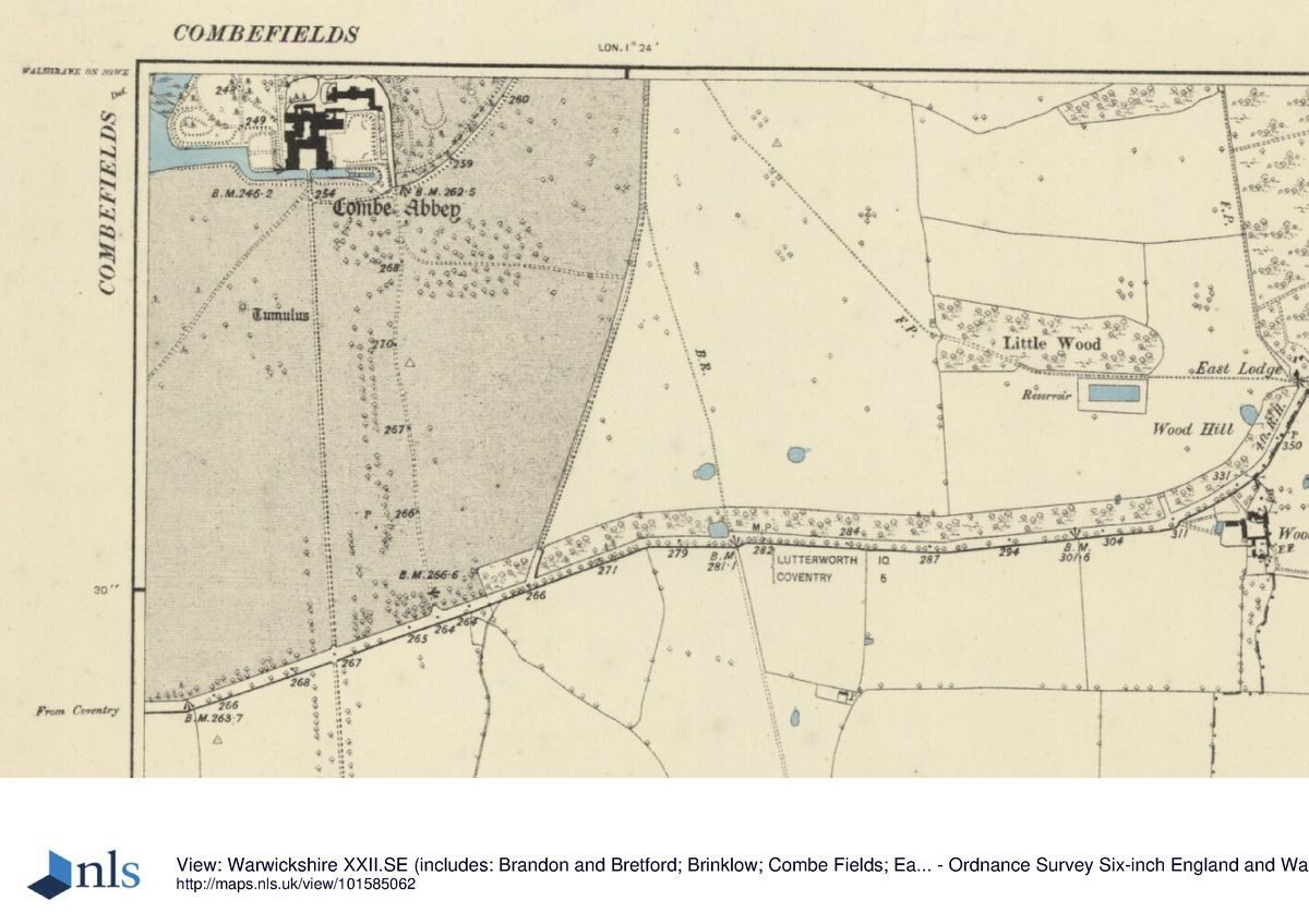
Combe Abbey is situated c 7km north-west of Rugby and c 4km east of Coventry, to the north of the A427 road. The c 270ha site comprises some 6ha of formal gardens and informal pleasure grounds, c 2ha of walled gardens, and c 262ha of parkland, lakes and avenues. The site is bounded to the south by the A427 road which runs west from the village of Brinklow to Coventry, while two avenues extend to the south of this road to the south and south-west of the house. To the west, north and north-east the site adjoins agricultural land, with the Rolls Royce engineering works c 1km north of the house, while to the east the site adjoins High Wood. A minor road leads north through the site from the A427 road towards Peter Hall and the site of the medieval villages of Upper and Lower Smite c 1.25km north-east of the house. The land to the north, west and south of the house is generally level. The Smite Brook flows from north-east to south-west through a shallow valley to the north and west of the house; this was dammed in the late C18 to form an extensive lake. To the east of the house the ground rises to East Lodge at the south-east corner of the park. There are views across surrounding agricultural land to the north and north-east from within the site, while to the south there are views across the A427 road towards Birchley Wood, The Grove and New Close Wood, areas of predominantly deciduous woodland through which the two avenues extend south towards the village of Brandon.
ENTRANCES AND APPROACHES
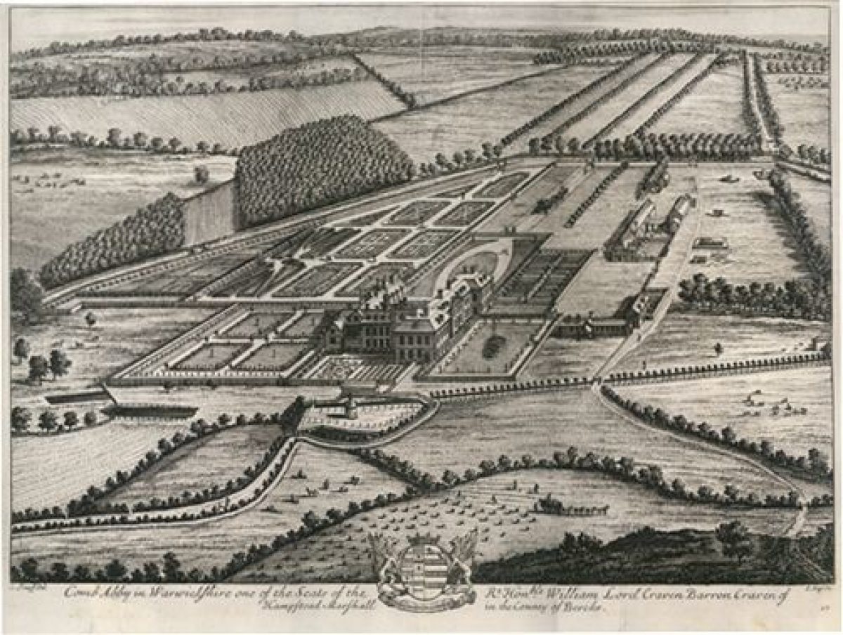
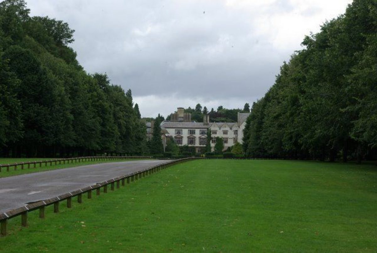
Combe Abbey is approached from the A427 to the south. The entrance is marked by a pair of late C18 rusticated stone piers (listed grade II) of rectangular section with carved swagged ornaments, and leads to a double avenue of limes and horse chestnuts through which the tarmac drive extends c 670m north to approach the south front of the house. The avenue is bordered by wide grass verges with mid and late C20 car-parking areas to the east, c 250m south-east of the house. The south drive assumed its present form in the mid C18 when a public road c 250m south of the house was diverted to the course of the present A427 road (Demidowicz and Fryer 1994). The axis of the south drive is projected beyond the A427 road by an avenue, the Twelve O'Clock Ride, which extends c 800m across agricultural land to The Grove. An avenue is shown on this alignment in Kip's engraving of c 1707. A service drive runs parallel to and c 100m east of the south drive, passing immediately to the east of the Great Garden and sweeping north-west round the gardens to reach the stables north of the house. The stables (listed grade II) comprise a late C18 brick range with mid C19 additions, including a picturesque clock turret by W E Nesfield.
A mid C19 stone bridge (listed grade I) supported by two unequally sized gothic arches carries the cobbled drive across the mid C19 moat to enter a courtyard enclosed by the west, north and east ranges of the house. The courtyard is today (2000) laid out with a stone-flagged carriage circle enclosing a circular formal garden comprising box-edged panels of grass, flower beds with seasonal planting and a circular pool with a simple fountain rising from a stone pinnacle. The present arrangement of the courtyard echoes W A Nesfield's scheme which is shown in early C20 photographs (Hall 1994); the bridge and moat also formed part of Nesfield's mid C19 alterations. A late C18 or early C19 view (Aylesford Collection) shows a carriage circle comprising a simple circular panel of grass within the courtyard and a drive approaching from the south across lawns. This arrangement formed part of Lancelot Brown's late C18 scheme, which in turn replaced formal gardens with statues, topiary and wrought-iron gates leading to the courtyard which are shown in an early C18 view engraved by S and N Buck. These details correspond broadly to the large forecourt and carriage circle shown in Kip's engraving of c 1707.
Further late C18 drives (disused, 2000) approach the house from the south-west and south-east. The late C18 West Lodge (listed grade II) is situated c 1km south-west of the house and comprises a central block containing a triumphal arched entrance flanked by single-storey wings. Of stone construction with classical ornaments and a pair of down-swept wrought-iron gates within the arch, West Lodge was designed by Henry Holland as part of Brown's scheme of improvements for the sixth Lord Craven. The Lodge originally contained two dwellings separated by the arch, but was converted to a single property in the late C20. West Lodge formerly led to a drive which led north-east across the deer park for c 980m to join the south drive c 50m south of the house; this drive was removed in the mid C20. The west drive was constructed by Brown for the sixth Lord Craven, partly following the course of the public road from Brinklow to Coventry which was diverted to the south c 1775. The late C18 East Lodge (listed grade II) stands on high ground c 1.3km south-east of the house and comprises a rendered octagonal range flanked by a pair of two-storey wings. The Lodge has ogee-headed gothic arched openings, blind arrow-slit motifs and a machicolated parapet to the central range. Designed by either Lancelot Brown or Henry Holland, East Lodge formed part of Brown's improvements for the sixth Lord Craven, and formerly led to a drive which extended west-north-west across agricultural land and parkland to reach the house. This drive had been removed by the late C19 (OS).
PRINCIPAL BUILDING
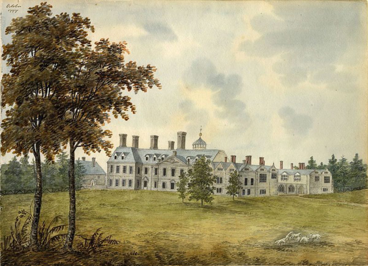
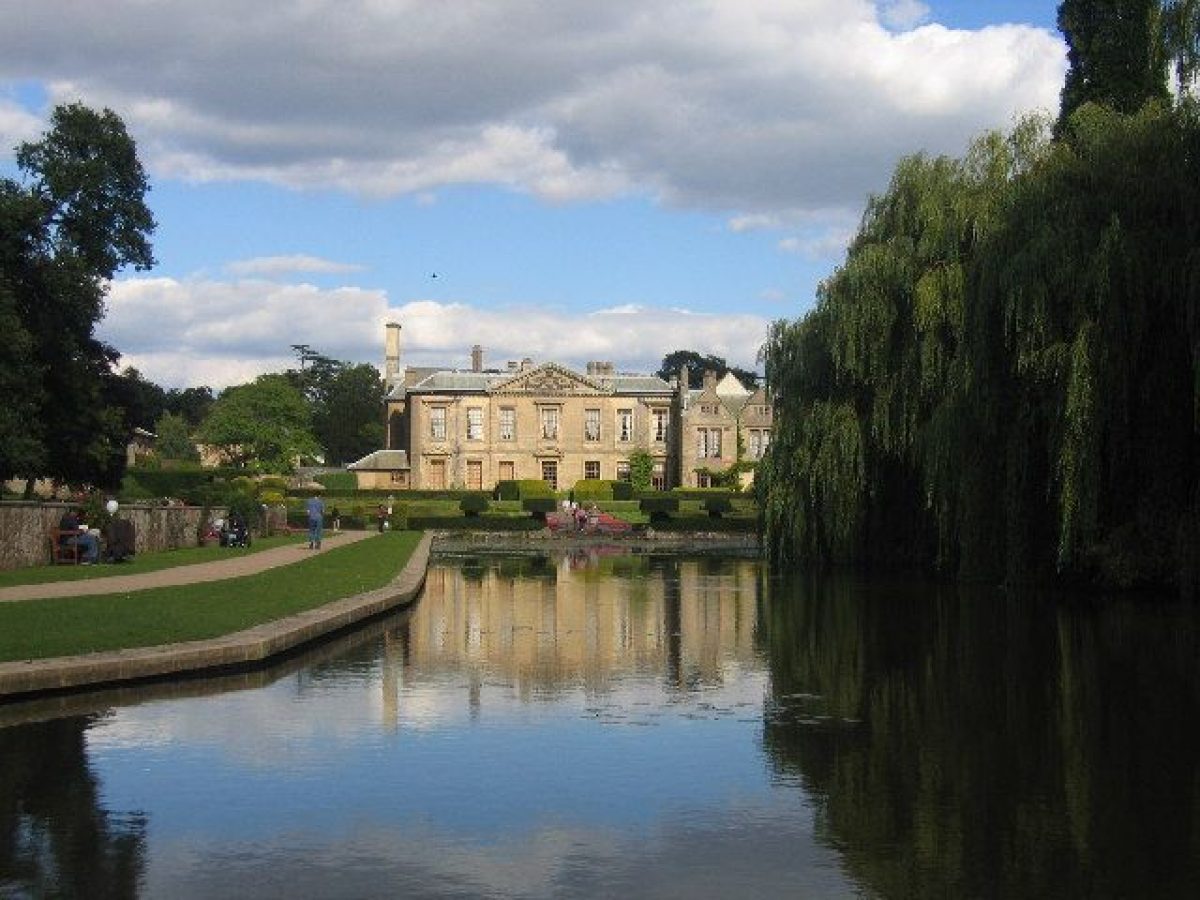
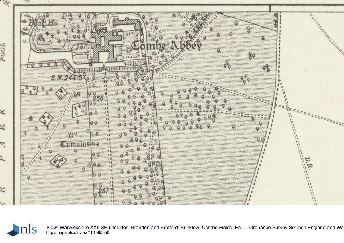
Combe Abbey (listed grade I) stands near the centre of the site on level ground and comprises three ranges constructed to the west, north and east of a courtyard which is enclosed to the south by a mid C19 stone parapet above a mid C19 moat constructed to the design of W A Nesfield. The present mansion incorporates elements of the C12 and C15 monastic buildings including the cloisters to the west and north-west of the courtyard, and the C12 warming room (rebuilt mid C19 by W E Nesfield) to the south-east. The ogee-headed cloister arches are filled with C16 windows; above, the first floor is lit by seven wooden-framed oriel windows. The west or garden facade was rebuilt in the late C17 to designs by William Winde and comprises a two-storey range under a hipped roof (rebuilt early C20) with a central pediment ornamented with an armorial achievement. A pavilion to the north-west was demolished after the sale of the Abbey by Lord Craven in 1923, while to the south-west a two-storey gabled range survives from a building constructed by Sir Isaac Gibson in 1667-9. Kip's early C18 engraving shows a matching pavilion at the south-west corner of the building, but Winde's late C17 elevation (Bodleian Library) indicates that this was never executed. The C16 north range was altered in the late C17, and again in the mid C19 when a new east range was constructed to designs by W E Nesfield. The three-storey east range was constructed with high pitched roofs, turrets and other gothic details, and a ground-floor arcade facing gardens to the east. Nesfield's east wing, completed in 1872, replaced a two-storey C16 wing to which a gallery had been added in the early C17 for the use of Princess Elizabeth. An elaborately carved stone first-floor porch at the south-east corner of the east wing led to raised walks surrounding the Great Garden; the porch is shown in the Bucks' engraving (1729) and a drawing by J G Jackson (1846). Nesfield's east range was in turn demolished after 1923, leaving only the ground-floor arches and elements of the C12 monastic structure. A late C20 wing has been built on the site of Nesfield's building, recalling his structure in some of its detail. Combe Abbey was disused from 1964 until the late C20, when it was let for use as an hotel.
GARDENS AND PLEASURE GROUNDS
The formal gardens are situated to the east and west of the house, with further areas of informal pleasure grounds to the north. Immediately to the east of the house an approximately rectangular area of lawn is enclosed to the north, east and south by raised banks, that to the east being retained by a low stone wall (listed grade II) of late C16 or early C17 origin. This sunken lawn corresponds to the early C17 Great Garden which was enclosed by raised walks connected to the house by the elaborate first-floor porch built by Lord Harington for Princess Elizabeth c 1603. In his engraving of c 1707 Kip shows the Great Garden enclosed to the north, east and south by raised walks, and divided into quarters by further walks. A plan (1897) by the third Earl's head gardener, William Miller, shows a quartered parterre on the site of the Great Garden; this does not survive. To the south, on the site of mid and late C20 car parks, Kip indicates a further garden comprising seven rectangular parterres and other formal features. These late C17 gardens, the design of which has been attributed to George London (d 1714) (Tyack 1994) do not survive. The gardens are today (2000) bounded to the south by a mid C19 moat which flows below the south facade of the east and west wings of the house. To the east the moat is terminated by a rocky cascade, while its south bank is planted with mixed ornamental trees and shrubs. The moat flows into the lake to the west, and to the north-west is bounded by a stone wall which retains the west terraces. Above the retaining wall a yew hedge is clipped into topiary 'mushroom' shapes. The moat and associated features formed part of W A Nesfield's improvements undertaken for the first Earl of Craven c 1850.
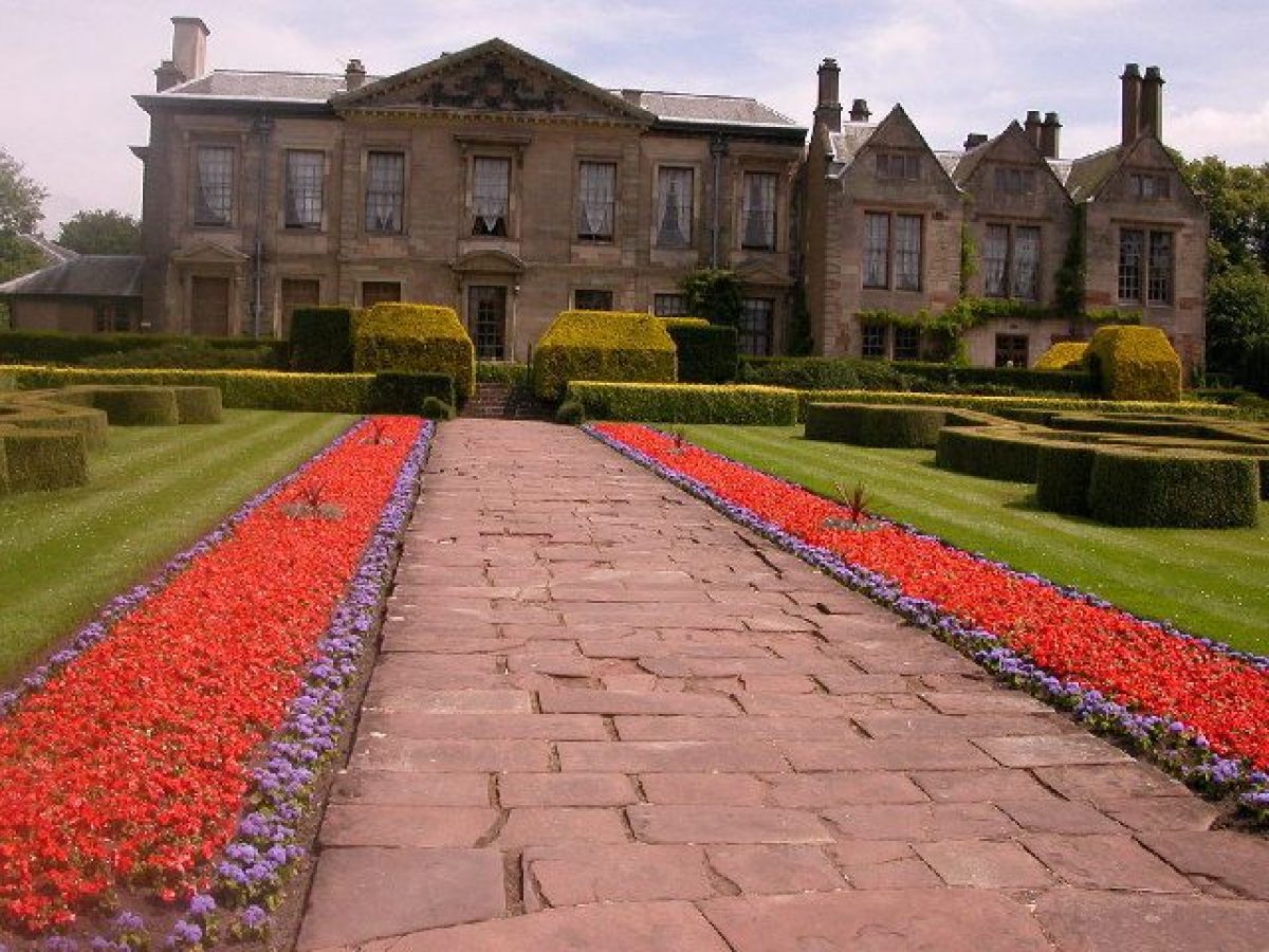
To the west of the house a series of formal terraces descend to the lake. The upper terrace below the west facade comprises a wide panel of grass, to the west of which a wide stone-flagged walk leads south to steps which descend to the moat, and north to a wrought-iron gate flanked by low stone piers surmounted by carved stone fishes which provides access to the pleasure grounds. The upper terrace is enclosed to the west by a clipped yew hedge, below which narrow borders are planted with seasonal subjects. A flight of stone steps aligned on the centre of the west facade descends to the lower terrace which is laid out with two symmetrical parterres formed by low box hedges set on lawns. The pattern of the parterres broadly reflects that shown on the plan of 1897 by William Miller; a pair of stone eagles on stone pedestals replaces late C19 central fountains (OS). The parterre lawns are divided by a central stone-flagged walk which leads west from the east steps to a further wide flight of steps which descends to the lake. To the north, west and south the parterre lawn is enclosed by yew hedges surmounted by further topiary 'mushrooms', while to the north, outside the hedge, a stone-flagged walk is adjoined by an area of lawn with panel beds containing seasonal planting. Stone steps flanked by repositioned mid C19 stone-carved winged griffins ascend to the informal pleasure grounds which are retained by a mid C19 stone wall (listed grade II). Ornamental fragments of the early C17 south-east porch are set into this wall, which extends c 130m west and north-west of the parterre, parallel to the eastern arm of the lake. The western extension of the wall retains a wide rectangular lawn with a herbaceous border to the north below a further buttressed retaining wall. The eastern arm of the lake is separated from the main body of water by a mid C19 stone balustrade, which today (2000) screens a late C20 tarmac visitors' walkway linking the north and south sides of the lake.
The informal pleasure grounds to the north-west of the Abbey comprise areas of lawn planted with C19 and C20 specimen trees and shrubs, with larger groups of ornamental trees and conifers to the north-west. A gravel walk continues the axis of the upper terrace north through the pleasure grounds, passing, c 50m north of the house, a late C19 dogs' cemetery set beneath a weeping ash, before curving north-west to pass to the north-east of a raised bank planted with evergreen shrubs and specimen conifers including a collection of Wellingtonias. A walk returns to the west of this mound, parallel to the canalised Smite Brook which feeds the lake to the south-west. At the southern end of this bank a circular arrangement of staddle stones support a late C19 or early C20 wrought-iron circle planted with wisteria. On the opposite side of the north-west lawn, c 130m west of the house, a late C19 aviary of timber and stone construction stands against a background planting of evergreen shrubs.
The pleasure grounds are today (2000) significantly simplified and reduced in area from that shown on William Miller's plan (1897), which in turn agrees in outline with the late C19 and early C20 OS maps. The extent of the pleasure grounds is marked to the north and south-east by a mid C18 ha-ha (Demidowicz and Fryer 1994). A circular flower garden to the north of the stables does not survive, and areas of ornamental garden to the north-west and south-east of the kitchen garden have reverted to paddock. Other ornamental features including a fountain on the axis of the principal north walk, a further circular flower garden and glades planted with specific species have been removed, while a grove of late C19 ornamental conifers c 320m north-north-west of the house now lies in a paddock. Similarly, the network of curvilinear gravel walks has been significantly reduced throughout the pleasure grounds. The late C19 gardens were developed from an initial scheme by W A Nesfield by the third Earl's gardener, William Miller. The appearance of the gardens ten years after Miller's retirement is recorded in photographs published by Country Life (1909). The mid and late C19 gardens replaced lawns planted with specimen trees which Brown laid out in the 1770s for the sixth Lord Craven (Stroud 1975). Brown's scheme in turn replaced a walled garden with a central oval fountain pool below the west facade, a walled parterre below the north facade, and a series of yards to the north-west and south-west with a dovecote to the north-west of the house. These features are shown on Kip's early C18 engraving.
PARK
Areas of park lie to the north-west and south-west of the house, with paddocks to the north-east and south-east. Today (2000), these areas remain pasture with scattered trees and more extensive areas of plantation, known as Little Wrautam, to the north-west, c 650m north-west of the house. A belt of woodland extends from Little Wrautam along the north and west sides of the lake, and the southern boundary of the park as far as East Lodge. This boundary plantation formed part of Brown's late C18 improvements. Further parkland to the east of the minor road which crosses the site from north to south c 450m east of the house is today in mixed agricultural use.
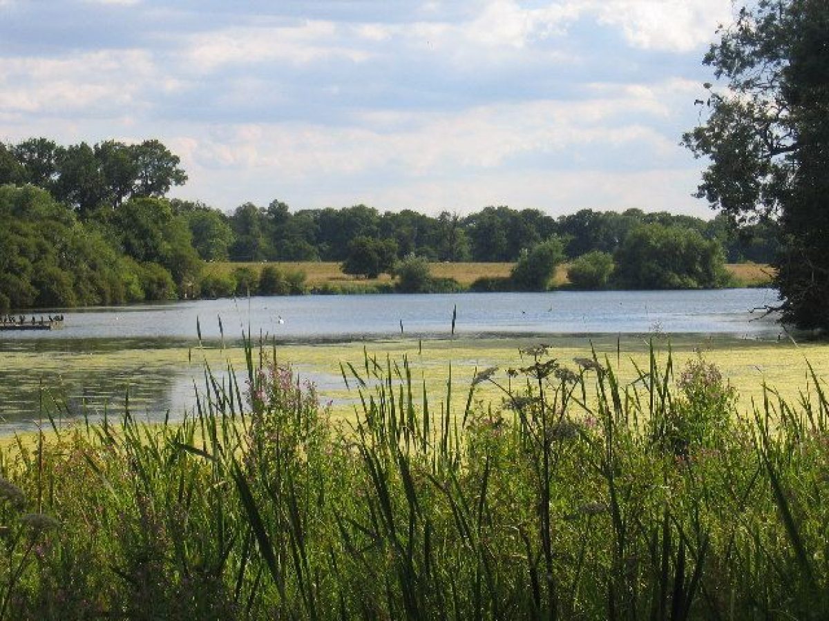
The west park is dominated by a serpentine lake created in the late C18 by Lancelot Brown, which flows west from the house towards the western boundary of the park where it sweeps south and south-east enclosing a broad promontory c 1.5km south-west of the house, on which stands the late C18 Menagerie (listed grade II). This stone structure comprises a polygonal two-storey range under a leaded dome flanked by a centre range and cross wing to the north. The Menagerie overlooks an area of grass and scrub woodland which is enclosed to the north-west and south-east by late C18 brick walls (both listed grade II), and to the west by the lake. An old quarry within the enclosure is utilised as an ornamental feature, while c 50m north of the Menagerie a group of one- and two-storey brick farm buildings (listed grade II) provided storage for feed and winter shelter for exotic animals. The Menagerie was constructed c 1770-8 to designs by Brown which were inspired by the Royal Menagerie at the Palace of Versailles, France; it is marked as the Menagerie on a plan of 1778. The Menagerie and its associated structures are a rare survival of a late C18 complex devoted to keeping rare and exotic animals. In the C20 the structure was converted to domestic use, at which time it was known as The Woodlands. A further early C20 house, Highfield, stands in the park c 160m north of the Menagerie. Some 500m north-east of the Menagerie a single-storey, late C18 brick boathouse (listed grade II), also to the designs of Brown, stands on the south side of the lake. The park to the south of the lake is predominantly level and open, with scattered specimen trees, some of which survive from early C18 formal avenues which were partly removed in the course of Brown's late C18 improvements (Andrews 1954). The kennels, designed by Brown in a gothic style, stood to the west of the south drive, c 500m south of the house; this structure had been removed by 1886 (OS). A late C20 brick visitors' centre designed with monumental classical porticoes to the north and south stands in the park c 130m south-west of the house.
The park to the north-east of the house is today (2000) divided into paddocks bounded to the north by the Smite Brook, and to the east by the minor road leading to Ansty. A series of earthwork remains of monastic fishponds survive in this area. To the north-west the Smite Brook is dammed to form a lake, Top Pool, while c 400m north-west of the house a star-shaped decoy pond is today overgrown and crossed by board walks used for bird-watching. A carriage drive leads north-west from the pleasure grounds, crossing the dam of Top Pool to pass through mixed woodland to reach Little Wrautam. To the south, an area known as Wrautam, today an extensive grassy glade enclosed to the north, west and south by woodland, accommodates late C20 children's play equipment. The carriage drive continues through the plantations on the north and west sides of the lake before joining a drive which leads north from the A427 road to the Menagerie; the return route from the Menagerie to the Abbey does not survive.
The carriage drive forms part of a late C18 circuit of drives through the park created by Brown for the sixth Lord Craven.
A park comprising 650 acres (c 270ha) was first enclosed at Combe by the first Lord Craven in 1634 (Tyack 1994). Kip's early C18 view indicates that a park lay to the south-west of the house, but its boundaries are unknown. The C17 park was extended to some 2000 acres (833ha) from the mid C18, when in 1754 the old road to the south of the house was removed to the course of the present A427 (Demidowicz and Fryer 1994).
KITCHEN GARDEN
The kitchen garden is situated c 130m north-east of the house and is enclosed by brick walls c 3m high. Rectangular on plan, the garden is today laid to grass. The centre of the south-west wall is formed into a short arcade of late C19 gothic arches supported by squat stone columns (altered, C20). The kitchen garden was constructed in the mid C18 (ibid), replacing areas of productive garden to the south-east and south-west of the house shown in Kip's early C18 engraving. This garden was remodelled in the late C19 by William Miller, who inserted the south-west arcade to allow views into the garden from the pleasure grounds which, in the late C19, surrounded the garden to the north-west, south-west and south-east. Miller's plan of 1897 shows the garden laid out in two parallel rows of five rectangular beds divided by walks, with a circular basin at the centre aligned on a walk leading south-east into the pleasure grounds; this arrangement does not survive. Glasshouses constructed against the inner face of the north-west wall and at the north-east end of the garden do not survive. A two-storey, late C19 brick gardener's house and a range of bothies and sheds stand to the north-west end of the garden.
REFERENCES
L Knyff and J Kip, Britannia Illustrata i, (1707), pl 47
J Beeverell, Les delices de la Grande Bretagne V, (1707), p 872
J Horticulture and Cottage Gardener, 33 (1865), pp 441-2; 42 (1869), pp 126-7; 50 (1873), pp 420-2
The Garden 1, (1872), pp 559-60
Gardeners' Chronicle, ii (1898), pp 229-31
C Holme, Gardens of England in the Midland and Eastern Counties (1908), pls 45, 46
Country Life, 26 (4 December 1909), pp 794-805; (11 December 1909), pp 840-9
Victoria History of the County of Warwickshire VI, (1951), pp 72-4
C B Andrews (ed), The Torrington Diaries (1954), pp 210-11
N Pevsner and A Wedgewood, The Buildings of England: Warwickshire (1966), pp 236-8
D Stroud, Capability Brown (1975), pp 143-4, 219
B Elliott, Victorian Gardens (1986), pp 112, 144, 146, 209
J Brown, The Art and Architecture of English Gardens (1989), pp 110-11
M Hall, The English Country House (1994), pp 53-9
Lancelot (Capability) Brown: Warwickshire Commissions, (Warwickshire Gardens Trust 1994), pp 14-18
G Tyack, Warwickshire Country Houses (1994), pp 57-63
'Gateway to Heaven', The Daily Telegraph, 16 October 1999, p 2
Maps
H Beighton, A Mapp of Warwickshire, surveyed 1722-5, published 1729
H Beighton, A Map of Knightlow Hundred, surveyed 1725, published 1730
Survey of Combe Abbey, 1778 (Bodleian Library, Oxford)
W Yates and Sons, Map of Warwickshire, surveyed 1787-9, published 1793
W Miller, The Gardens of the Earl of Craven - Coombe Abbey, Warwickshire, 1897 (RIBA)
OS Old Series 1" to 1 mile, published 1834
OS 6" to 1 mile:
1st edition published 1886
2nd edition published 1905-6
3rd edition published 1926
1938 edition
OS 25" to 1 mile:
1st edition published 1886
2nd edition published 1905
3rd edition published 1925
Illustrations
W Winde, The Upright of the new building at Comb Abbey, c 1682 (Bodleian Library, Oxford, MS Gough drawings a2, f81)
S and N Buck, The South View of Combe-Abbey in the County of Warwick, 1729 (Warwickshire County Record Office)
Maria Johnson, Watercolour views of Combe Abbey including The Menagerie, West Lodge and Kennels, 1797 (Herbert Art Gallery, Coventry)
Watercolour, Combe Abbey from the south-east, c 1800 (Aylesford Collection, Birmingham Reference Library Archive)
W E Nesfield, drawings for Combe Abbey, mid C19 (D1381-1400-1907), (Victoria & Albert Museum)
Photograph, Combe Abbey from the north-west, c 1860 (private collection)
Photographs for Country Life, 1909 (NMR)
Description written: June 2000
Amended: July 2000, September 2000
Register Inspector: JML
Edited: December 2000
- Visitor Access, Directions & Contacts
Telephone
024 7645 0450Website
https://www.coombeabbey.comAccess contact details
02476 453720 Country park open daily, 7.30 to dusk.
Directions
5 miles east of Coventry, off the B4027 south of the M6.
Owners
City of Coventry
Council House, Earl Street, Coventry,, CV1 5RR
- History
The following is from the Register of Parks and Gardens of Special Historic Interest. For the most up-to-date Register entry, please visit the The National Heritage List for England (NHLE):
www.historicengland.org.uk/listing/the-list
HISTORIC DEVELOPMENT
The Cistercian monastery of Combe was founded by Richard de Camville in 1150 (VCH). In the C13 the monks enclosed the adjacent villages of Upper and Lower Smite to create sheep pasture, and in the C15 the monastic buildings were improved. The monastery was dissolved in 1539 and the site granted to Mary, Duchess of Somerset and Richmond, who in turn conveyed it to John Dudley, later Duke of Northumberland. In 1557 the estate was sold to Robert Kelway, Surveyor of the Court of Wards and Liveries, who until 1578 let it to a Leicester merchant, Sir William Wigston. At Kelway's death in 1581 Combe passed to his daughter, Elizabeth, who was married to John Harington of Exton, Rutland (qv). Harington converted the former monastic buildings into one of the most substantial houses in the county (Tyack 1994). John Harington was created a baron in 1603, and from 1603 to 1608 served as guardian to James I's daughter, Princess Elizabeth, who was accommodated at Combe. Lord Harington died in 1613 leaving Combe to his sister, Lucy, Countess of Bedford, who in turn sold it in 1622 to Elizabeth, widow of a former Lord Mayor of London, Sir William Craven. Lady Craven built up a group of estates for her son in Berkshire, where until 1714 the family had its principal residence at Hampstead Marshall (today known as Hamstead Gardens, Berkshire, qv). Sir William's son, also William, was a soldier fighting for the Protestant powers during the Thirty Years War; this led to his elevation to the peerage as Lord Craven of Hampstead Marshall in 1627. Lord Craven acted as Protector to Princess Elizabeth, now the widow of the Elector Palatine and former King of Bohemia. Craven's estates were sequestrated under the Commonwealth, but following their restoration in 1662 Lord Craven was created an earl. An ambitious programme of rebuilding at Ashdown (qv), Caversham Park (qv) and Hampstead Marshall then followed in the mid C17. Combe was occupied by the Earl of Craven's godson and agent, Sir Isaac Gibson, and subsequently by the Earl's cousin and heir, Sir William Craven. In 1682-9 William Winde rebuilt portions of the house for Lord Craven, and modifications were made to existing formal gardens; this work is shown in a bird's-eye engraving of c 1707 by J Kip. The Earl of Craven died in 1697 and was succeeded by his cousin's son as second Baron Craven. The third Baron Craven died childless in 1734 and was succeeded by his brother, Fulwar, who in turn died unmarried in 1764. A cousin, William Craven, inherited the title and estate, and died without issue in 1769, when he was succeeded as sixth baron by his nephew, also William. In 1771-7 the sixth Lord Craven commissioned Lancelot Brown (1716-83) to landscape the C17 park surrounding Combe Abbey, and a series of landscape structures including lodges, kennels and a menagerie were built to designs either by Brown, or his son-in-law, Henry Holland (1745-1806). The sixth Baron's wife gained notoriety by absconding to Europe with the Margrave of Anspach, whom she married in 1791. The sixth Lord Craven died in 1791 and was succeeded by his son, William, seventh Baron Craven, who in 1801 was created Earl of Craven. The second Earl, who inherited Combe in 1825, commissioned William Eden Nesfield (1835-88) to build a new east wing in 1866-72, while at the same period his father, William Andrews Nesfield (1793-1881), designed formal gardens around the house. These were further developed by the third Earl's gardener, William Miller (1828-1909), who after his retirement in 1899 set up in practice as a landscape gardener at Berkswell, Warwickshire. The third Earl, who had inherited in 1866, died in 1883 and was succeeded by his son, William, fourth Earl of Craven, who was drowned in a yachting accident in 1921. Combe Abbey and 120 acres (50ha) were sold by the fifth Earl in 1923 to John Gray, a Coventry builder, who demolished and altered parts of the house. In 1952 Gray leased the house to the General Electric Company for use as a hostel. At Gray's death in 1964 the property was sold to Coventry City Council. Today (2000) the house and formal gardens are leased for use as an hotel, while the park is a country park run by the City Council; other areas of the site are in divided private ownership.
Combe Abbey is one of a group of sites in Warwickshire at which Lancelot Brown advised in the mid and late C18. These include Charlecote Park (qv), Compton Verney (qv), Newnham Paddox (qv), Packington Hall (qv), Ragley Hall (qv) and Warwick Castle (qv).
Period
- 18th Century (1701 to 1800)
- Late 18th Century (1767 to 1800)
- Associated People
- Features & Designations
Designations
The National Heritage List for England: Register of Parks and Gardens
- Reference: GD1374
- Grade: II*
Style
English Landscape Garden
Features
- Ornamental Lake
- Moat
- Ornamental Bridge
- Lawn
- Topiary
- Parterre
- Lawn
- Sculpture
- House (featured building)
- Description: The former monastic buildings were converted into a house from 1581 onwards. It has since been re-built and re-modelled a number of times.
- Earliest Date:
- Key Information
Type
Park
Purpose
Recreational/sport
Principal Building
Commercial
Period
18th Century (1701 to 1800)
Survival
Extant
Hectares
270
Open to the public
Yes
Civil Parish
Combe Fields
- References
References
- {English Heritage Register of Parks and Gardens of Special Historic Interest}, (Swindon: English Heritage, 2008) [on CD-ROM] Historic England Register of Parks and Gardens of Special Historic Interest
- Elliott, B., {Victorian Gardens} (London: Batsford, 1986), pp. 112, 144, 146, 209 Victorian Gardens
- Pevsner, N. and A. Wedgwood, {The Buildings of England: Warwickshire} (Harmondsworth: Penguin Books, 1966), pp. 236-8 The Buildings of England: Warwickshire
- Tyack, G., {Warwickshire Country Houses} (Chichester: Phillimore, 1994), p. 57-63 Warwickshire Country Houses
- Holme, C G, {The Gardens of England in the Midland and Eastern Counties} ([n.p]: Studio, 1908), plates 45 and 46 The Gardens of England in the Midland and Eastern Counties
- {Victoria History of the County of Warwickshire Volume 6} ([n.p.]: [n.pub], 1951), pp. 72-4 Victoria County History: Warwick, Volume 6